
Heho
Encyclopedia
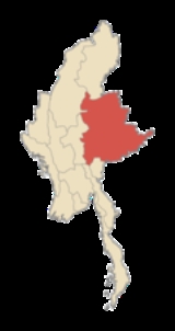
Heho is a small town in Kalaw Township
, Taunggyi District
, Shan State
of Myanmar
(formerly Burma). It is the primary air gateway to tourist areas such as Inle Lake
.
Heho is connected by NH4
to Sakangyi
and Taunggyi
, the capital of the Shan State in the east. A dirt road northwest from Heho leads to the old silver-lead mines of Maw Son (Baw Zaing).
. The village grew into a town in the 1920s when the single-line railway line was extended from Aungban
to Shwenyaung, and Heho was determined to be a convenient intermediate stop and transfer point. Later an airport
was built, 2.5 miles northwest of the town. The airport
served as an airbase both for the Allies and the Japanese
during World War II
. The airbase was heavily bombed by the Allies
. Evidence of aircraft bunker revetments and bomb craters can still be seen on the southern end of the airfield, especially noticeable from the air.
Kalaw Township
Kalaw Township is a township of Taunggyi District in the Shan State of Myanmar. The principal town is Kalaw. This township contains Kalaw , Aungban and Heho....
, Taunggyi District
Taunggyi District
Taunggyi District is a district of Shan State in Burma. The principal town and administrative center is Taunggyi. This district has 12 towns and 3001 villages.-Townships:The district contains the following townships:*Taunggyi Township*Nyaungshwe Township...
, Shan State
Shan State
Shan State is a state of Burma . Shan State borders China to the north, Laos to the east, and Thailand to the south, and five administrative divisions of Burma in the west. Largest of the 14 administrative divisions by land area, Shan State covers 155,800 km², almost a quarter of the total...
of Myanmar
Myanmar
Burma , officially the Republic of the Union of Myanmar , is a country in Southeast Asia. Burma is bordered by China on the northeast, Laos on the east, Thailand on the southeast, Bangladesh on the west, India on the northwest, the Bay of Bengal to the southwest, and the Andaman Sea on the south....
(formerly Burma). It is the primary air gateway to tourist areas such as Inle Lake
Inle Lake
Inle Lake is a freshwater lake located in the Nyaungshwe Township of Taunggyi District of Shan State, part of Shan Hills in Myanmar . It is the second largest lake in Myanmar with an estimated surface area of , and one of the highest at an altitude of...
.
Heho is connected by NH4
National Highway 4 (Burma)
National Highway 4 is an important west-east flowing highway of central Burma. It connects the town of Meiktila in the Mandalay Division to Tachileik in Shan State in the east on the border with Thailand...
to Sakangyi
Sakangyi, Taunggyi
Sakangyi is a town in Taunggyi Township in Taunggyi District in the Shan State of eastern Burma. It is located west along National Highway 4 from Aye Thar Yar and Taunggyi. The National Road 43 begins in the eastern part of the town and connects National Highway 4 to National Highway 3 in the north...
and Taunggyi
Taunggyi
-Transportation:The main access to Taunggyi is by road. A railway line that passes through Taunggyi was recently built in 1995, but at the moment it offers no passenger service. Regular railway passenger service to the rest of the country is through the town of Shwenyaung, twelve miles to the...
, the capital of the Shan State in the east. A dirt road northwest from Heho leads to the old silver-lead mines of Maw Son (Baw Zaing).
History
It was a small village of Danu peopleDanu people
The Danu people are a sub-ethnic group of the Bamar, predominantly populating the areas near Pindaya Caves, in Shan State of Burma. They speak an archaic dialect of Burmese.-External links:*...
. The village grew into a town in the 1920s when the single-line railway line was extended from Aungban
Aungban
Aungban is a town in the Shan State of eastern Burma. It is located in Kalaw Township in Taunggyi District.It is the junction for a branch railway to Loikaw constructed in 1992.-External links:*...
to Shwenyaung, and Heho was determined to be a convenient intermediate stop and transfer point. Later an airport
Heho Airport
-History:The airport served as an airbase both for the Allies and the Japanese during World War II. The airbase was heavily bombed by the Allies. Evidence of aircraft bunker revetments and bomb craters can still be seen on the southern end of the airfield, especially noticeable from the...
was built, 2.5 miles northwest of the town. The airport
Airport
An airport is a location where aircraft such as fixed-wing aircraft, helicopters, and blimps take off and land. Aircraft may be stored or maintained at an airport...
served as an airbase both for the Allies and the Japanese
Empire of Japan
The Empire of Japan is the name of the state of Japan that existed from the Meiji Restoration on 3 January 1868 to the enactment of the post-World War II Constitution of...
during World War II
World War II
World War II, or the Second World War , was a global conflict lasting from 1939 to 1945, involving most of the world's nations—including all of the great powers—eventually forming two opposing military alliances: the Allies and the Axis...
. The airbase was heavily bombed by the Allies
Allies of World War II
The Allies of World War II were the countries that opposed the Axis powers during the Second World War . Former Axis states contributing to the Allied victory are not considered Allied states...
. Evidence of aircraft bunker revetments and bomb craters can still be seen on the southern end of the airfield, especially noticeable from the air.