

List of North Carolina rivers
Encyclopedia
By drainage basinDrainage basinA drainage basin is an extent or an area of land where surface water from rain and melting snow or ice converges to a single point, usually the exit of the basin, where the waters join another waterbody, such as a river, lake, reservoir, estuary, wetland, sea, or ocean...
This list is arranged by drainage basin, with respective tributaries alphabetically indented under each larger stream's name. Atlantic OceanAtlantic OceanThe Atlantic Ocean is the second-largest of the world's oceanic divisions. With a total area of about , it covers approximately 20% of the Earth's surface and about 26% of its water surface area...
- North Landing RiverNorth Landing RiverThe North Landing River is a river in the United States state of Virginia.-References:**USGS Hydrologic Unit Map - State of Virginia...
- Northwest River
- Pasquotank RiverPasquotank RiverThe Pasquotank River is a coastal water-body in Northeastern North Carolina in the United States. Located between Camden and Pasquotank counties, the Pasquotank connects directly to the Albemarle Sound and is part of the Intracoastal Waterway via Elizabeth City.-History:The name "Pasquotank" is...
- Little River
- Perquimans RiverPerquimans RiverThe Perquimans River is a coastal waterway in Northeastern North Carolina in the United States. Located entirely within Perquimans county, the river drains directly to the Albemarle Sound between Durant's Neck on the north and Harvey Neck on the south. It is a tidal estuary to just north of the...
- Yeopim River
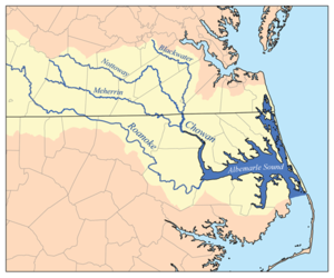
- Chowan RiverChowan RiverThe Chowan River is a blackwater river formed with the merging of Virginia's Blackwater and Nottoway rivers near the stateline between Virginia and North Carolina. According to the USGS a variant name is Choan River....
- Wiccacon River
- Meherrin RiverMeherrin RiverThe Meherrin River is a long river in the U.S. states of Virginia and North Carolina. It begins in central Virginia, about northwest of Emporia, and flows roughly east-southeast into North Carolina, where it joins the larger Chowan River....
- Roanoke RiverRoanoke RiverThe Roanoke River is a river in southern Virginia and northeastern North Carolina in the United States, 410 mi long. A major river of the southeastern United States, it drains a largely rural area of the coastal plain from the eastern edge of the Appalachian Mountains southeast across the Piedmont...
- Cashie River
- Dan RiverDan RiverThe Dan River flows in the U.S. states of North Carolina and Virginia. It originates in Patrick County, Virginia, and crosses the state border into Stokes County, North Carolina. It then flows into Rockingham County. From there it goes back into Virginia. It reenters North Carolina near the...
- Hyco RiverHyco RiverThe Hyco River is a tributary of the Dan River, which is a tributary of the Roanoke River. All three rivers flow through the U.S. states of North Carolina and Virginia. In Person County, North Carolina the Hyco River is impounded by a dam, forming Hyco Lake...
- Mayo RiverMayo River (Dan River)The Mayo River is a tributary of the Dan River, which in turn is a tributary of the Roanoke River. All three rivers flow through the U.S. states of Virginia and North Carolina. It is named for Major William Mayo .-Course:...
- Hyco River
- Scuppernong RiverScuppernong River (North Carolina)The Scuppernong River is a blackwater river that flows through Tyrrell County and Washington County, North Carolina into the Albemarle Sound. It is a tributary of the Pasquotank River Basin...
- Alligator RiverAlligator River (North Carolina)The Alligator River is a small river in eastern North Carolina, USA, separating Dare County with Tyrrell County. It is a tributary of the Albemarle Sound and is part of the Alligator River National Wildlife Refuge. The Lindsey C. Warren Bridge of U.S. Route 64 crosses the river.A 21-mile canal...
- Long Shoal River
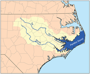
- Pamlico RiverPamlico RiverThe Pamlico River is a tidal river that flows into Pamlico Sound, in North Carolina in the United States of America. It is formed by the confluence of the Tar River and Tranters Creek....
- Pungo RiverPungo RiverThe Pungo River is a river in eastern North Carolina, USA. It originally began in the Great Dismal Swamp in Washington County, North Carolina; the upper part of the river has since been supplanted by the Pungo River Canal, dug in the 1950s to improve drainage of local farmland. The river flows...
- Tar RiverTar RiverThe Tar River is a river that is approximately long, of northeast North Carolina flowing generally southeast to an estuary of Pamlico Sound. The Tar River becomes the tidal Pamlico River once it underpasses the U.S...
- Fishing Creek
- Pungo River
- Bay RiverBay RiverThe Bay River , also known as the Sapang River or the San Nicolas River, is a river system in Bay, Laguna. It is one of 21 major tributaries of Laguna de Bay and is the more southern of two small rivers that hem the town proper of Bay.The other is the Calo River , another Laguna de Bay tributary,...
- Neuse RiverNeuse RiverThe Neuse River is a river rising in the Piedmont of North Carolina and emptying into Pamlico Sound below New Bern. Its total length is approximately , making it the longest river entirely contained in North Carolina. The Trent River joins it at New Bern. Its drainage basin, measuring in area,...
- South RiverSouth River (Neuse River estuary)The South River is a tidal estuary, approximately 8 mi long long in Carteret County, North Carolina in the United States.It flows NNE and empties into the estuary of the Neuse River near its entrance into Pamlico Sound. The town of South River sits on western side near its mouth.-See...
- Trent River
- Contentnea Creek
- Little River
- Crabtree Creek
- Ellerbe CreekEllerbe CreekThe Ellerbe Creek is tributary of the Neuse River in North Carolina, USA. It is part of the Neuse River Basin, and flows for more than twenty miles through North Durham....
- Eno RiverEno RiverThe Eno River, named for the Eno Indians who once lived along its banks, is the initial tributary of the Neuse River in North Carolina, USA.The Eno rises in Orange County. The river's watershed occupies most of Orange and Durham counties...
- Little River
- Flat RiverFlat River (North Carolina)The Flat River is a river in southern Person County, North Carolina and a portion of Durham County, North Carolina.The river flows from Person County to combine with the Little and Eno rivers to flow into the Neuse River...
- South River
- North RiverNorth River (North Carolina)The North River is a tidal river, approximately 18 miles long, in eastern North Carolina, the United States. It forms the boundary between Currituck and Camden counties....
- Newport RiverNewport RiverThe Newport River is a small river in North Carolina that runs approximately twenty kilometers southeast through the town of Newport with its mouth opening into Bogue Sound, between Morehead City and Beaufort. It is popular for flatwater paddling and canoeing....
- White Oak RiverWhite Oak RiverThe White Oak River is a blackwater river, approximately 40 mi long, on the coastal plain of southeast North Carolina in the United States. It empties in the Atlantic Ocean.-Course:...
- New RiverNew River (North Carolina)The New River is a 50-mile long river in southeastern North Carolina in the United States. It empties into the Atlantic Ocean.It rises in northwestern Onslow County and flows east-southeast past Jacksonville, where it widens into a tidal estuary approximately two miles wide...
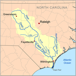
- Cape Fear RiverCape Fear RiverThe Cape Fear River is a long blackwater river in east central North Carolina in the United States. It flows into the Atlantic Ocean near Cape Fear, from which it takes its name. The overall water quality of the river is continuously measured and monitored by and conducted by the , , and the...
- Northeast Cape Fear RiverNortheast Cape Fear RiverThe Northeast Cape Fear River is a blackwater river tributary of the Cape Fear River, approximately 130 mi long, in southeastern North Carolina in the United States....
- Black RiverBlack River (North Carolina)The Black River is a tributary of the Cape Fear River, approximately 50 mi long, in southeastern North Carolina in the United States....
- South RiverSouth River (North Carolina)For other places named South River, see South River .The South River is a tributary of the Black River, approximately 75 mi long, in southeastern North Carolina in the United States....
- Black River
- Great Coharie Creek
- Little Coharie Creek
- Six Runs Creek
- South River
- Little River
- Upper Little River
- Deep RiverDeep River (North Carolina)The Deep River is a tributary of the Cape Fear River, approximately 125 miles long, in north central North Carolina in the United States.- Course :...
- Rocky River
- Haw RiverHaw RiverThe Haw River is a tributary of the Cape Fear River, approximately 110 mi long, that is entirely contained in north central North Carolina in the United States...
- New Hope River (submerged)
- New Hope CreekNew Hope CreekNew Hope Creek is a watercourse that rises in rural Orange County, North Carolina, in the United States. It drains the western portion of Orange County and the southern half of Durham County and flows into the northern end of Jordan Lake reservoir. The drainage area encompasses urban, suburban and...
- New Hope Creek
- Big Alamance Creek
- Little Alamance Creek
- New Hope River (submerged)
- Northeast Cape Fear River
- Lockwood Folly RiverLockwood Folly RiverLockwood Folly River or Lockwood's Folly River is a short tidal river in Brunswick County, North Carolina, USA. Waters from the Green Swamp drain into the river near Supply and flow southward to empty into the Atlantic Intracoastal Waterway near Sunset Harbor...
- Shallotte RiverShallotte RiverThe Shallotte River is a tidal river in Brunswick County, North Carolina, USA. Waters drain from the tributaries of the Green Swamp near the town of Shallotte and flow south down the river to empty into the Atlantic Intracoastal Waterway....
- Little River
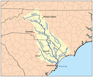
- Pee Dee RiverPee Dee RiverThe Pee Dee River, also known as the Great Pee Dee River, is a river in North Carolina and South Carolina. It originates in the Appalachian Mountains in North Carolina, where its upper course above the mouth of the Uwharrie River is known as the Yadkin River. It is extensively dammed for flood...
- Waccamaw RiverWaccamaw RiverThe Waccamaw River is a river, approximately 140 miles long, in southeastern North Carolina and eastern South Carolina in the United States. It drains an area of approximately 1110 square miles in the coastal plain along the eastern border between the two states into the Atlantic Ocean...
- Little Pee Dee River (SC)
- Lumber RiverLumber RiverThe Lumber River is a river in south-central North Carolina in the flat Coastal Plain. European settlers first called the river Drowning Creek, which still is the name of its headwater. The waterway known as the Lumber River extends downstream from the Scotland County-Hoke County border to the...
- Lumber River
- Lynches RiverLynches RiverLynches River, named for Thomas Lynch, Jr., signer of the Declaration of Independence, rises in North Carolina near Waxhaw, North Carolina, at about 700 feet elevation, flowing only a short distance to the South Carolina border, and thence to join the Pee Dee River nearJohnsonville...
- Little River
- Rocky RiverRocky River (North Carolina)The Rocky River is a river in the Piedmont region of North Carolina. It begins in Iredell County near Mooresville and flows south into Cabarrus County, where it is the principal waterway in the county. The river continues southeastward to form the line between Stanly, Union, and Anson counties...
- Coddle CreekCoddle CreekCoddle Creek is a stream/river that rises near Mooresville in Iredell County, North Carolina. It flows through most of northwestern Cabarrus County, North Carolina where it empties into Rocky River near Harrisburg, North Carolina....
- Coddle Creek
- Uwharrie RiverUwharrie RiverThe Uwharrie River is a river, about 60 mi long, in the Piedmont region of central North Carolina in the United States. It is a tributary of the Pee Dee River, which flows to the Atlantic Ocean.- Course :...
- Little Uwharrie River
- Yadkin RiverYadkin RiverThe Yadkin River is one of the longest rivers in North Carolina, flowing . It rises in the northwestern portion of the state near the Blue Ridge Parkway's Thunder Hill Overlook. Several parts of the river are impounded by dams for water, power, and flood control. The river becomes the Pee Dee...
- Abbotts CreekAbbotts Creek, North CarolinaAbbotts Creek starts in Winston-Salem, NC in Forsyth County and becomes High Rock Lake near Lexington, NC in Davidson County just north of Hwy 47. The section of High Rock Lake that is officially Abbotts Creeks ends near the Hwy 8 causeway, in Southmont, NC....
- South Yadkin River
- Little Yadkin River
- Ararat RiverArarat RiverThe Ararat River is a tributary of the Yadkin River in southwestern Virginia and northwestern North Carolina in the United States. Via the Yadkin it is part of the watershed of the Pee Dee River, which flows to the Atlantic Ocean....
- Elkin River
- Fisher RiverFisher River (North Carolina)The Fisher River is a tributary of the Yadkin River in northwestern North Carolina in the United States, also draining a very small portion of southwestern Virginia. Via the Yadkin it is part of the watershed of the Pee Dee River, which flows to the Atlantic Ocean...
- Little Fisher River
- Mitchell RiverMitchell River (North Carolina)The Mitchell River is a tributary of the Yadkin River in northwestern North Carolina in the United States. Via the Yadkin it is part of the watershed of the Pee Dee River, which flows to the Atlantic Ocean...
- Mulberry River
- Roaring RiverRoaring River (North Carolina)The Roaring River is a tributary of the Yadkin River in northwestern North Carolina in the United States. Via the Yadkin it is part of the watershed of the Pee Dee River, which flows to the Atlantic Ocean...
- Reddies RiverReddies RiverThe Reddies River is a tributary of the Yadkin River in northwestern North Carolina in the United States. Via the Yadkin it is part of the watershed of the Pee Dee River, which flows to the Atlantic Ocean...
- Abbotts Creek
- Waccamaw River
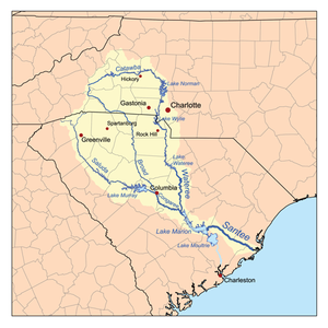
- Santee River (SC)
- Wateree River (SC)
- Catawba RiverCatawba RiverThe Catawba River is a tributary of the Wateree River in the U.S. states of North Carolina and South Carolina. The river is approximately 220 miles long...
- Lower Little River
- Middle Little River
- Upper Little River
- Johns River
- Linville RiverLinville RiverThe Linville River is a river in western North Carolina. The river begins in the slopes of Peak Mountain, Sugar Mountain and Flattop Mountain, in the Linville Gap . As it goes south through Avery County, it passes through the communities of Grandfather, Linville, Pineola, Crossnore and finally at...
- Catawba River
- Congaree River (SC)
- Broad RiverBroad River (Carolinas)The Broad River is a principal tributary of the Congaree River, about 150 miles long, in western North Carolina and northern South Carolina in the United States. Via the Congaree, it is part of the watershed of the Santee River, which flows to the Atlantic Ocean...
- Pacolet River (SC)
- North Pacolet RiverPacolet RiverThe Pacolet River is a tributary of the Broad River, about 50 miles long, in northwestern South Carolina in the United States . One of its principal headwaters tributaries also drains a small portion of western North Carolina. Via the Broad and Congaree Rivers, it is part of the watershed of the...
- North Pacolet River
- First Broad RiverFirst Broad RiverThe First Broad River is a tributary of the Broad River, about 60 mi long in western North Carolina in the United States . Via the Broad and Congaree Rivers, it is part of the watershed of the Santee River, which flows to the Atlantic Ocean ....
- Second Broad RiverSecond Broad RiverThe Second Broad River is a tributary of the Broad River in western North Carolina in the United States. Via the Broad and Congaree rivers, it is part of the watershed of the Santee River, which flows to the Atlantic Ocean....
- Green RiverGreen River (North Carolina)The Green River in North Carolina, United States, is perhaps best known as one of the extreme whitewater kayaking challenges in North America that is run on a regular basis....
- Hungry RiverHungry RiverThe Hungry River flows in western North Carolina, USA. It flows its entire course within Henderson County. It arises in eastern Henderson County and flows southwesterly before it empties into the Green River....
- Little Hungry River
- Hungry River
- Pacolet River (SC)
- Broad River
- Wateree River (SC)
- Savannah River (SC)
- Seneca River (SC)
- Keowee River (SC)
- Toxaway RiverToxaway RiverThe Toxaway River is a waterway that flows south from headwaters in Transylvania County, North Carolina, into Lake Toxaway and over Toxaway Falls, after which it crosses into South Carolina and enters Lake Jocassee, the reservoir behind Lake Jocassee Dam....
- Horsepasture RiverHorsepasture RiverThe Horsepasture River is an National Wild and Scenic river in the U.S. states of North Carolina and South Carolina. The river rises in Jackson County, North Carolina, and flows through the Jocassee Gorges area and ends at Lake Jocassee in South Carolina...
- Horsepasture River
- Whitewater RiverWhitewater River (Keowee River)The Whitewater River is a river that flows south from headwaters in Transylvania County, North Carolina, over Upper Whitewater Falls and Lower Whitewater Falls before crossing into South Carolina and entering Lake Jocassee, the reservoir behind Lake Jocassee Dam.In Lake Jocassee the Whitewater...
- Thompson River
- Toxaway River
- Keowee River (SC)
- Tugaloo River (SC)
- Chattooga RiverChattooga RiverThe Chattooga River is the main tributary of the Tugaloo River. Its headwaters are located southwest of Cashiers, North Carolina, and it stretches to where it has its confluence with the Tallulah River within Lake Tugalo, held back by the Tugalo Dam...
- Tallulah RiverTallulah RiverThe Tallulah River is a river in Georgia and North Carolina. It begins in Clay County, North Carolina, near Standing Indian Mountain in the Southern Nantahala Wilderness and flows south into Georgia, crossing the state line into Towns County. The river then travels through Rabun County and ends in...
- Coleman RiverColeman RiverColeman River is a stream that is located in the Blue Ridge Mountains, mostly within Rabun County, Georgia. It is one of the main tributaries of the Tallulah River. The headwaters of Coleman River are located in Clay County, North Carolina, and the river travels a short distance before crossing...
- Coleman River
- Chattooga River
- Seneca River (SC)
Gulf of MexicoGulf of MexicoThe Gulf of Mexico is a partially landlocked ocean basin largely surrounded by the North American continent and the island of Cuba. It is bounded on the northeast, north and northwest by the Gulf Coast of the United States, on the southwest and south by Mexico, and on the southeast by Cuba. In...
- Mississippi River
- Ohio River (KY, WV)
- Tennessee River (KY,TN)
- Hiwassee RiverHiwassee RiverThe Hiwassee River has its headwaters on the north slope of Rocky Mountain in Towns County in northern Georgia and flows northward into North Carolina before turning westward into Tennessee, flowing into the Tennessee River a few miles west of State Route 58 in Meigs County, Tennessee...
- Nottely RiverNottely RiverThe Nottely River is a river in the United States. The river originates in the Blue Ridge Mountains in northern Georgia. The river flows for into the artificial Hiwassee Reservoir in North Carolina...
- Valley River
- Nottely River
- Little Tennessee RiverLittle Tennessee RiverThe Little Tennessee River is a tributary of the Tennessee River, approximately 135 miles long, in the Appalachian Mountains in the southeastern United States.-Geography:...
- Cheoah RiverCheoah RiverThe Cheoah River is a tributary of the Little Tennessee River in North Carolina in the United States.It is located in Graham County in far western North Carolina, near Robbinsville, and is approximately 20 miles in length...
- Tuckasegee River
- Oconaluftee River
- Nantahala RiverNantahala RiverThe Nantahala River is a river in western North Carolina in the United States, within the Nantahala National Forest, and near the Great Smoky Mountains National Park. Two-lane U.S...
- Cullasaja RiverCullasaja RiverThe Cullasaja River is a short river located entirely in Macon County, North Carolina. It is a tributary of the Little Tennessee River , into which it flows near the county seat of Franklin. It originates to the southeast, near Highlands, the county's only other town...
- Cheoah River
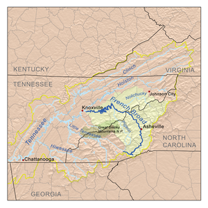
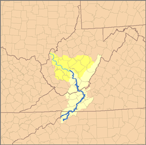
- French Broad RiverFrench Broad RiverThe French Broad River flows from near the village of Rosman in Transylvania County, North Carolina, into the state of Tennessee. Its confluence with the Holston River at Knoxville is the beginning of the Tennessee River....
- Nolichucky RiverNolichucky RiverThe Nolichucky River is a major stream draining the Blue Ridge Mountains of western North Carolina and east Tennessee. The river is long.-Hydrography:...
- Cane River
- North Toe RiverNorth Toe RiverThe North Toe River is a large stream in the North Carolina High Country. The headwaters begin between Bald Mountain and Sugar Mountain, what is known as Sugar Gap, in Avery County. The river proceeds to go southwest till it ends with a confluence with the Cane River, forming the Nolichucky River...
- South Toe RiverSouth Toe RiverThe South Toe River , is a stream in Yancey County...
- South Toe River
- Pigeon RiverPigeon River (Tennessee - North Carolina)The Pigeon River of western North Carolina and east Tennessee rises above Canton, North Carolina. Below this, it flows roughly parallel to Interstate 40 for many miles and is impounded by a dam -- Walters Dam -- belonging to Progress Energy before entering Tennessee, where it flows into the French...
- Swannanoa RiverSwannanoa RiverThe Swannanoa River flows through the Swannanoa Valley of western North Carolina, and is a major tributary to the French Broad River. It begins at its headwaters in Black Mountain, NC, however, it also has a major tributary near its headwaters: Flat Creek, which begins on the slopes of Mount...
- Mills RiverMills River (North Carolina)The Mills River is located in Transylvania and Henderson counties, North Carolina, USA is a tributary of the French Broad River. The river flows out of the Pisgah Ranger District of the Pisgah National Forest in two forks: the North Fork, which drains the slopes just south of the Blue Ridge...
- Little River
- Davidson River
- Ivy River (Creek)
- Nolichucky River
- Hiwassee River
- Tennessee River (KY,TN)
- Ohio River (KY, WV)
-
-
-
- Holston River (TN)
- South Fork Holston River (TN)
- Watauga RiverWatauga RiverThe Watauga River is a large stream of western North Carolina and East Tennessee. It is 60 miles long with its headwaters on the slopes of Grandfather Mountain and Peak Mountain in Watauga County, North Carolina.-Hydrography:...
- Elk RiverElk River (North Carolina)The Elk River is a large stream in the North Carolina High Country and East Tennessee. The headwaters begin from the Northwestern slopes of Peak Mountain in Avery County, North Carolina and end at the Watauga River in Carter County, Tennessee.-Hydrography:...
- Elk River
- Watauga River
- South Fork Holston River (TN)
- Holston River (TN)
- Kanawha River (WV)
- New River
- Little River
- North Fork New RiverNorth Fork New RiverThe North Fork New River is a river in the U.S. state of North Carolina. It rises in Northern Watauga County, and flows northeast to Ashe County where it joins with the South Fork New River to form the New River....
- South Fork New RiverSouth Fork New RiverThe South Fork New River is a river in the U.S. state of North Carolina.It stretches from its headwaters at a spring near Blowing Rock and the Eastern Continental Divide and meanders northward along the northwestern face of the Blue Ridge Mountains through the eastern and central portions of...
- New River
-
-
Alphabetically
- Alligator RiverAlligator River (North Carolina)The Alligator River is a small river in eastern North Carolina, USA, separating Dare County with Tyrrell County. It is a tributary of the Albemarle Sound and is part of the Alligator River National Wildlife Refuge. The Lindsey C. Warren Bridge of U.S. Route 64 crosses the river.A 21-mile canal...
- Ararat RiverArarat RiverThe Ararat River is a tributary of the Yadkin River in southwestern Virginia and northwestern North Carolina in the United States. Via the Yadkin it is part of the watershed of the Pee Dee River, which flows to the Atlantic Ocean....
- Black RiverBlack River (North Carolina)The Black River is a tributary of the Cape Fear River, approximately 50 mi long, in southeastern North Carolina in the United States....
- Broad RiverBroad River (Carolinas)The Broad River is a principal tributary of the Congaree River, about 150 miles long, in western North Carolina and northern South Carolina in the United States. Via the Congaree, it is part of the watershed of the Santee River, which flows to the Atlantic Ocean...
- Cane River
- Cape Fear RiverCape Fear RiverThe Cape Fear River is a long blackwater river in east central North Carolina in the United States. It flows into the Atlantic Ocean near Cape Fear, from which it takes its name. The overall water quality of the river is continuously measured and monitored by and conducted by the , , and the...
- Cashie River
- Catawba RiverCatawba RiverThe Catawba River is a tributary of the Wateree River in the U.S. states of North Carolina and South Carolina. The river is approximately 220 miles long...
- Cheoah RiverCheoah RiverThe Cheoah River is a tributary of the Little Tennessee River in North Carolina in the United States.It is located in Graham County in far western North Carolina, near Robbinsville, and is approximately 20 miles in length...
- Chowan RiverChowan RiverThe Chowan River is a blackwater river formed with the merging of Virginia's Blackwater and Nottoway rivers near the stateline between Virginia and North Carolina. According to the USGS a variant name is Choan River....
- Coleman RiverColeman RiverColeman River is a stream that is located in the Blue Ridge Mountains, mostly within Rabun County, Georgia. It is one of the main tributaries of the Tallulah River. The headwaters of Coleman River are located in Clay County, North Carolina, and the river travels a short distance before crossing...
- Cullasaja RiverCullasaja RiverThe Cullasaja River is a short river located entirely in Macon County, North Carolina. It is a tributary of the Little Tennessee River , into which it flows near the county seat of Franklin. It originates to the southeast, near Highlands, the county's only other town...
- Dan RiverDan RiverThe Dan River flows in the U.S. states of North Carolina and Virginia. It originates in Patrick County, Virginia, and crosses the state border into Stokes County, North Carolina. It then flows into Rockingham County. From there it goes back into Virginia. It reenters North Carolina near the...
- Davidson River
- Deep RiverDeep River (North Carolina)The Deep River is a tributary of the Cape Fear River, approximately 125 miles long, in north central North Carolina in the United States.- Course :...
- Elk RiverElk River (North Carolina)The Elk River is a large stream in the North Carolina High Country and East Tennessee. The headwaters begin from the Northwestern slopes of Peak Mountain in Avery County, North Carolina and end at the Watauga River in Carter County, Tennessee.-Hydrography:...
- Eno RiverEno RiverThe Eno River, named for the Eno Indians who once lived along its banks, is the initial tributary of the Neuse River in North Carolina, USA.The Eno rises in Orange County. The river's watershed occupies most of Orange and Durham counties...
- First Broad RiverFirst Broad RiverThe First Broad River is a tributary of the Broad River, about 60 mi long in western North Carolina in the United States . Via the Broad and Congaree Rivers, it is part of the watershed of the Santee River, which flows to the Atlantic Ocean ....
- Fisher RiverFisher River (North Carolina)The Fisher River is a tributary of the Yadkin River in northwestern North Carolina in the United States, also draining a very small portion of southwestern Virginia. Via the Yadkin it is part of the watershed of the Pee Dee River, which flows to the Atlantic Ocean...
- French Broad RiverFrench Broad RiverThe French Broad River flows from near the village of Rosman in Transylvania County, North Carolina, into the state of Tennessee. Its confluence with the Holston River at Knoxville is the beginning of the Tennessee River....
- Great Pee Dee RiverPee Dee RiverThe Pee Dee River, also known as the Great Pee Dee River, is a river in North Carolina and South Carolina. It originates in the Appalachian Mountains in North Carolina, where its upper course above the mouth of the Uwharrie River is known as the Yadkin River. It is extensively dammed for flood...
- Green RiverGreen River (North Carolina)The Green River in North Carolina, United States, is perhaps best known as one of the extreme whitewater kayaking challenges in North America that is run on a regular basis....
- Haw RiverHaw RiverThe Haw River is a tributary of the Cape Fear River, approximately 110 mi long, that is entirely contained in north central North Carolina in the United States...
- Hungry RiverHungry RiverThe Hungry River flows in western North Carolina, USA. It flows its entire course within Henderson County. It arises in eastern Henderson County and flows southwesterly before it empties into the Green River....
- Hyco RiverHyco RiverThe Hyco River is a tributary of the Dan River, which is a tributary of the Roanoke River. All three rivers flow through the U.S. states of North Carolina and Virginia. In Person County, North Carolina the Hyco River is impounded by a dam, forming Hyco Lake...
- Johns River
- Linville RiverLinville RiverThe Linville River is a river in western North Carolina. The river begins in the slopes of Peak Mountain, Sugar Mountain and Flattop Mountain, in the Linville Gap . As it goes south through Avery County, it passes through the communities of Grandfather, Linville, Pineola, Crossnore and finally at...
- Little River (Albemarle Sound)
- Little River (Cape Fear River)
- Little River (Eno River)
- Little River (French Broad River)
- Little River (Horry County, South Carolina)
- Little River (Jacob Fork)
- Little River (Neuse River)
- Little River (North Carolina-Virginia)
- Little River (Pee Dee River)
- Little River (Roanoke River)
- Little Fisher River
- Little Hungry River
- Little Tennessee RiverLittle Tennessee RiverThe Little Tennessee River is a tributary of the Tennessee River, approximately 135 miles long, in the Appalachian Mountains in the southeastern United States.-Geography:...
- Little Uwharrie River
- Lockwood Folly RiverLockwood Folly RiverLockwood Folly River or Lockwood's Folly River is a short tidal river in Brunswick County, North Carolina, USA. Waters from the Green Swamp drain into the river near Supply and flow southward to empty into the Atlantic Intracoastal Waterway near Sunset Harbor...
- Lower Little River
- Lumber RiverLumber RiverThe Lumber River is a river in south-central North Carolina in the flat Coastal Plain. European settlers first called the river Drowning Creek, which still is the name of its headwater. The waterway known as the Lumber River extends downstream from the Scotland County-Hoke County border to the...
- Lynches RiverLynches RiverLynches River, named for Thomas Lynch, Jr., signer of the Declaration of Independence, rises in North Carolina near Waxhaw, North Carolina, at about 700 feet elevation, flowing only a short distance to the South Carolina border, and thence to join the Pee Dee River nearJohnsonville...
- Mayo RiverMayo River (Dan River)The Mayo River is a tributary of the Dan River, which in turn is a tributary of the Roanoke River. All three rivers flow through the U.S. states of Virginia and North Carolina. It is named for Major William Mayo .-Course:...
- Meherrin RiverMeherrin RiverThe Meherrin River is a long river in the U.S. states of Virginia and North Carolina. It begins in central Virginia, about northwest of Emporia, and flows roughly east-southeast into North Carolina, where it joins the larger Chowan River....
- Middle Little River
- Mills RiverMills River (North Carolina)The Mills River is located in Transylvania and Henderson counties, North Carolina, USA is a tributary of the French Broad River. The river flows out of the Pisgah Ranger District of the Pisgah National Forest in two forks: the North Fork, which drains the slopes just south of the Blue Ridge...
- Mitchell RiverMitchell River (North Carolina)The Mitchell River is a tributary of the Yadkin River in northwestern North Carolina in the United States. Via the Yadkin it is part of the watershed of the Pee Dee River, which flows to the Atlantic Ocean...
- Nantahala RiverNantahala RiverThe Nantahala River is a river in western North Carolina in the United States, within the Nantahala National Forest, and near the Great Smoky Mountains National Park. Two-lane U.S...
- Neuse RiverNeuse RiverThe Neuse River is a river rising in the Piedmont of North Carolina and emptying into Pamlico Sound below New Bern. Its total length is approximately , making it the longest river entirely contained in North Carolina. The Trent River joins it at New Bern. Its drainage basin, measuring in area,...
- New Hope River
- New River - western North Carolina
- New RiverNew River (North Carolina)The New River is a 50-mile long river in southeastern North Carolina in the United States. It empties into the Atlantic Ocean.It rises in northwestern Onslow County and flows east-southeast past Jacksonville, where it widens into a tidal estuary approximately two miles wide...
- southeastern North Carolina - Nolichucky RiverNolichucky RiverThe Nolichucky River is a major stream draining the Blue Ridge Mountains of western North Carolina and east Tennessee. The river is long.-Hydrography:...
- North Toe RiverNorth Toe RiverThe North Toe River is a large stream in the North Carolina High Country. The headwaters begin between Bald Mountain and Sugar Mountain, what is known as Sugar Gap, in Avery County. The river proceeds to go southwest till it ends with a confluence with the Cane River, forming the Nolichucky River...
- North Pacolet RiverPacolet RiverThe Pacolet River is a tributary of the Broad River, about 50 miles long, in northwestern South Carolina in the United States . One of its principal headwaters tributaries also drains a small portion of western North Carolina. Via the Broad and Congaree Rivers, it is part of the watershed of the...
- North RiverNorth River (North Carolina)The North River is a tidal river, approximately 18 miles long, in eastern North Carolina, the United States. It forms the boundary between Currituck and Camden counties....
- Northeast Cape Fear RiverNortheast Cape Fear RiverThe Northeast Cape Fear River is a blackwater river tributary of the Cape Fear River, approximately 130 mi long, in southeastern North Carolina in the United States....
- Pamlico RiverPamlico RiverThe Pamlico River is a tidal river that flows into Pamlico Sound, in North Carolina in the United States of America. It is formed by the confluence of the Tar River and Tranters Creek....
- Pasquotank RiverPasquotank RiverThe Pasquotank River is a coastal water-body in Northeastern North Carolina in the United States. Located between Camden and Pasquotank counties, the Pasquotank connects directly to the Albemarle Sound and is part of the Intracoastal Waterway via Elizabeth City.-History:The name "Pasquotank" is...
- Pee Dee RiverPee Dee RiverThe Pee Dee River, also known as the Great Pee Dee River, is a river in North Carolina and South Carolina. It originates in the Appalachian Mountains in North Carolina, where its upper course above the mouth of the Uwharrie River is known as the Yadkin River. It is extensively dammed for flood...
- Perquimans RiverPerquimans RiverThe Perquimans River is a coastal waterway in Northeastern North Carolina in the United States. Located entirely within Perquimans county, the river drains directly to the Albemarle Sound between Durant's Neck on the north and Harvey Neck on the south. It is a tidal estuary to just north of the...
- Pigeon RiverPigeon River (Tennessee - North Carolina)The Pigeon River of western North Carolina and east Tennessee rises above Canton, North Carolina. Below this, it flows roughly parallel to Interstate 40 for many miles and is impounded by a dam -- Walters Dam -- belonging to Progress Energy before entering Tennessee, where it flows into the French...
- Reddies RiverReddies RiverThe Reddies River is a tributary of the Yadkin River in northwestern North Carolina in the United States. Via the Yadkin it is part of the watershed of the Pee Dee River, which flows to the Atlantic Ocean...
- Roanoke RiverRoanoke RiverThe Roanoke River is a river in southern Virginia and northeastern North Carolina in the United States, 410 mi long. A major river of the southeastern United States, it drains a largely rural area of the coastal plain from the eastern edge of the Appalachian Mountains southeast across the Piedmont...
(Staunton River) - Roaring RiverRoaring River (North Carolina)The Roaring River is a tributary of the Yadkin River in northwestern North Carolina in the United States. Via the Yadkin it is part of the watershed of the Pee Dee River, which flows to the Atlantic Ocean...
- Rocky RiverRocky River (North Carolina)The Rocky River is a river in the Piedmont region of North Carolina. It begins in Iredell County near Mooresville and flows south into Cabarrus County, where it is the principal waterway in the county. The river continues southeastward to form the line between Stanly, Union, and Anson counties...
- Scuppernong RiverScuppernong River (North Carolina)The Scuppernong River is a blackwater river that flows through Tyrrell County and Washington County, North Carolina into the Albemarle Sound. It is a tributary of the Pasquotank River Basin...
- Second Broad RiverSecond Broad RiverThe Second Broad River is a tributary of the Broad River in western North Carolina in the United States. Via the Broad and Congaree rivers, it is part of the watershed of the Santee River, which flows to the Atlantic Ocean....
- Shallotte RiverShallotte RiverThe Shallotte River is a tidal river in Brunswick County, North Carolina, USA. Waters drain from the tributaries of the Green Swamp near the town of Shallotte and flow south down the river to empty into the Atlantic Intracoastal Waterway....
- Six Run CreekSix Run CreekSix Run Creek is a tributary of the Black River, approximately long, in southeastern North Carolina in the United States.It rises in northeastern Sampson County, approximately north of Clinton and flows generally south. In southern Sampson County, approximately south of Clinton, it joins Great...
- South RiverSouth River (North Carolina)For other places named South River, see South River .The South River is a tributary of the Black River, approximately 75 mi long, in southeastern North Carolina in the United States....
- South River (Neuse River estuary)South River (Neuse River estuary)The South River is a tidal estuary, approximately 8 mi long long in Carteret County, North Carolina in the United States.It flows NNE and empties into the estuary of the Neuse River near its entrance into Pamlico Sound. The town of South River sits on western side near its mouth.-See...
- South Toe RiverSouth Toe RiverThe South Toe River , is a stream in Yancey County...
- South Yadkin River
- Swannanoa RiverSwannanoa RiverThe Swannanoa River flows through the Swannanoa Valley of western North Carolina, and is a major tributary to the French Broad River. It begins at its headwaters in Black Mountain, NC, however, it also has a major tributary near its headwaters: Flat Creek, which begins on the slopes of Mount...
- Tar RiverTar RiverThe Tar River is a river that is approximately long, of northeast North Carolina flowing generally southeast to an estuary of Pamlico Sound. The Tar River becomes the tidal Pamlico River once it underpasses the U.S...
- Trent River
- Tuckasegee River
- Upper Little River
- Uwharrie RiverUwharrie RiverThe Uwharrie River is a river, about 60 mi long, in the Piedmont region of central North Carolina in the United States. It is a tributary of the Pee Dee River, which flows to the Atlantic Ocean.- Course :...
- Waccamaw RiverWaccamaw RiverThe Waccamaw River is a river, approximately 140 miles long, in southeastern North Carolina and eastern South Carolina in the United States. It drains an area of approximately 1110 square miles in the coastal plain along the eastern border between the two states into the Atlantic Ocean...
- Watauga RiverWatauga RiverThe Watauga River is a large stream of western North Carolina and East Tennessee. It is 60 miles long with its headwaters on the slopes of Grandfather Mountain and Peak Mountain in Watauga County, North Carolina.-Hydrography:...
- White Oak RiverWhite Oak RiverThe White Oak River is a blackwater river, approximately 40 mi long, on the coastal plain of southeast North Carolina in the United States. It empties in the Atlantic Ocean.-Course:...
- Whitewater RiverWhitewater River (Keowee River)The Whitewater River is a river that flows south from headwaters in Transylvania County, North Carolina, over Upper Whitewater Falls and Lower Whitewater Falls before crossing into South Carolina and entering Lake Jocassee, the reservoir behind Lake Jocassee Dam.In Lake Jocassee the Whitewater...
- Wiccacon River
- Yadkin RiverYadkin RiverThe Yadkin River is one of the longest rivers in North Carolina, flowing . It rises in the northwestern portion of the state near the Blue Ridge Parkway's Thunder Hill Overlook. Several parts of the river are impounded by dams for water, power, and flood control. The river becomes the Pee Dee...