

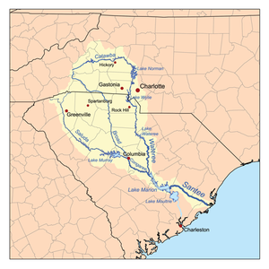
Catawba River
Encyclopedia
Tributary
A tributary or affluent is a stream or river that flows into a main stem river or a lake. A tributary does not flow directly into a sea or ocean...
of the Wateree River
Wateree River
The Wateree River, about 75 mi long, is a tributary of the Santee River in central South Carolina in the United States, which flows to the Atlantic Ocean...
in the U.S. state
U.S. state
A U.S. state is any one of the 50 federated states of the United States of America that share sovereignty with the federal government. Because of this shared sovereignty, an American is a citizen both of the federal entity and of his or her state of domicile. Four states use the official title of...
s of North Carolina
North Carolina
North Carolina is a state located in the southeastern United States. The state borders South Carolina and Georgia to the south, Tennessee to the west and Virginia to the north. North Carolina contains 100 counties. Its capital is Raleigh, and its largest city is Charlotte...
and South Carolina
South Carolina
South Carolina is a state in the Deep South of the United States that borders Georgia to the south, North Carolina to the north, and the Atlantic Ocean to the east. Originally part of the Province of Carolina, the Province of South Carolina was one of the 13 colonies that declared independence...
. The river is approximately 220 miles (350 km) long. It rises in the Appalachian Mountains
Appalachian Mountains
The Appalachian Mountains #Whether the stressed vowel is or ,#Whether the "ch" is pronounced as a fricative or an affricate , and#Whether the final vowel is the monophthong or the diphthong .), often called the Appalachians, are a system of mountains in eastern North America. The Appalachians...
and drains into Piedmont
Piedmont (United States)
The Piedmont is a plateau region located in the eastern United States between the Atlantic Coastal Plain and the main Appalachian Mountains, stretching from New Jersey in the north to central Alabama in the south. The Piedmont province is a physiographic province of the larger Appalachian division...
, and is impounded through a series of reservoirs for flood control and hydroelectricity
Hydroelectricity
Hydroelectricity is the term referring to electricity generated by hydropower; the production of electrical power through the use of the gravitational force of falling or flowing water. It is the most widely used form of renewable energy...
. The river is named after the Catawba
Catawba (tribe)
The Catawba are a federally recognized tribe of Native Americans, known as the Catawba Indian Nation. They live in the Southeast United States, along the border between North and South Carolina near the city of Rock Hill...
tribe of Native Americans
Native Americans in the United States
Native Americans in the United States are the indigenous peoples in North America within the boundaries of the present-day continental United States, parts of Alaska, and the island state of Hawaii. They are composed of numerous, distinct tribes, states, and ethnic groups, many of which survive as...
. They were known in their own language as the Kawahcatawbas, "the people of the river".
It rises in the Blue Ridge Mountains
Blue Ridge Mountains
The Blue Ridge Mountains are a physiographic province of the larger Appalachian Mountains range. This province consists of northern and southern physiographic regions, which divide near the Roanoke River gap. The mountain range is located in the eastern United States, starting at its southern-most...
in western McDowell County, North Carolina
McDowell County, North Carolina
-Cities and towns:*Marion *Old Fort-Unincorporated places:*West Marion*Little Switzerland*Nebo*Glenwood*Pleasant Gardens*North Cove-Education:The following is a list of schools located in McDowell County:*Marion Elementary School...
, approximately 20 miles (30 km) east of Asheville
Asheville, North Carolina
Asheville is a city in and the county seat of Buncombe County, North Carolina, United States. It is the largest city in Western North Carolina, and the 11th largest city in North Carolina. The City is home to the United States National Climatic Data Center , which is the world's largest active...
. It flows ENE, forming, along with the Linville River, Lake James. It then passes north of Morganton
Morganton, North Carolina
Morganton is a city in Burke County, North Carolina, United States. Reader's Digest included Morganton in its list of top ten places to raise a family. The town was recently profiled in The 50 Best Small Southern Towns. The population was 17,310 at the 2000 census...
, then southeast through the Lake Norman
Lake Norman
Lake Norman, created between 1959 and 1964 as part of the construction of the Cowans Ford Dam by Duke Energy, is the largest manmade body of fresh water located in North Carolina.-General Information:...
reservoir. From Lake Norman it flows south, passing west of Charlotte
Charlotte, North Carolina
Charlotte is the largest city in the U.S. state of North Carolina and the seat of Mecklenburg County. In 2010, Charlotte's population according to the US Census Bureau was 731,424, making it the 17th largest city in the United States based on population. The Charlotte metropolitan area had a 2009...
, then flowing through the Mountain Island Lake
Mountain Island Lake
Mountain Island Lake was created in 1924 to coincide with the building of Mountain Island Hydroelectric Station. It is named after the mountain which appears as an island in the lake. Full pond elevation is approximately...
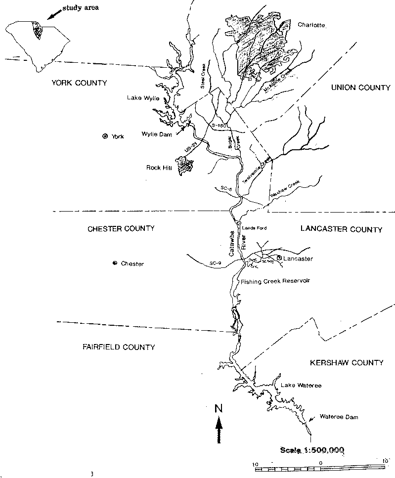
and Lake Wylie
Lake Wylie
Lake Wylie is a reservoir, or man-made lake in the U.S. states of both South Carolina and North Carolina. The lake has a surface area of and features of shore line.-History:...
reservoirs, where it forms approximately 10 miles (15 km) of the border between North Carolina and South Carolina. It flows into northern South Carolina, passing Rock Hill
Rock Hill, South Carolina
Rock Hill is the largest city in York County, South Carolina and the fourth-largest city in the state. It is also the third-largest city of the Charlotte metropolitan area, behind Charlotte and Concord, North Carolina. The population was 71,459 as of . Rock Hill has undergone rapid growth between...
, then through Fishing Creek Reservoir near Great Falls
Great Falls, South Carolina
Great Falls is a town in Chester County, South Carolina, United States. The population was 2,194 at the 2000 census.-Geography and climate:Great Falls is located at ....
, and then into the Lake Wateree
Lake Wateree
Lake Wateree is a reservoir in Kershaw, Fairfield, and Lancaster counties, South Carolina, in the United States. It is one of South Carolina's oldest man-made lakes. It has of shoreline and includes Lake Wateree State Recreation Area, a bird refuge, and Shaw Air Force Base Recreation center...
reservoir, approximately 30 miles (50 km) northeast of Columbia
Columbia, South Carolina
Columbia is the state capital and largest city in the U.S. state of South Carolina. The population was 129,272 according to the 2010 census. Columbia is the county seat of Richland County, but a portion of the city extends into neighboring Lexington County. The city is the center of a metropolitan...
. At the now-submerged confluence with Wateree Creek, it becomes the Wateree River
Wateree River
The Wateree River, about 75 mi long, is a tributary of the Santee River in central South Carolina in the United States, which flows to the Atlantic Ocean...
.
Dams
North Carolina
- Lake JamesLake JamesLake James is a large reservoir in the mountains of Western North Carolina which straddles the border between Burke and McDowell Counties. It is named for tobacco tycoon and benefactor of Duke University, James Buchanan Duke. The lake lies behind a series of 4 earthen dams, and was created by...
Dam - RhodhissRhodhiss, North CarolinaRhodhiss is a town in Caldwell and Burke counties in the U.S. state of North Carolina. The population was 366 at the 2000 census. It is part of the Hickory–Lenoir–Morganton Metropolitan Statistical Area.-Geography:...
Dam - Oxford Dam
- Lookout Shoals Dam
- Cowans Ford DamCowans Ford DamThe Cowans Ford Dam is a dam completed in 1963 along the Catawba River on the border between Lincoln and Mecklenburg counties in North Carolina. The dam holds back Lake Norman and is an important source of hydroelectric power.-See also:...
, creating Lake NormanLake NormanLake Norman, created between 1959 and 1964 as part of the construction of the Cowans Ford Dam by Duke Energy, is the largest manmade body of fresh water located in North Carolina.-General Information:... - Mountain Island Lake Dam
South Carolina
- Lake WylieLake WylieLake Wylie is a reservoir, or man-made lake in the U.S. states of both South Carolina and North Carolina. The lake has a surface area of and features of shore line.-History:...
Dam in India HookIndia Hook, South CarolinaIndia Hook is a census-designated place in York County, South Carolina, United States and is considered to be a suburb of the city of Rock Hill and one of the three communities on Lake Wylie.The population was 2,051 at the 2010 census.-Geography:... - Fishing Creek Reservoir in Great FallsGreat Falls, South CarolinaGreat Falls is a town in Chester County, South Carolina, United States. The population was 2,194 at the 2000 census.-Geography and climate:Great Falls is located at ....
- Dearborn-Great Falls Dam
- Cedar Creek Reservoir Dam
- Lake WatereeLake WatereeLake Wateree is a reservoir in Kershaw, Fairfield, and Lancaster counties, South Carolina, in the United States. It is one of South Carolina's oldest man-made lakes. It has of shoreline and includes Lake Wateree State Recreation Area, a bird refuge, and Shaw Air Force Base Recreation center...
Dam
Controversy
In 2006 the river became the center of a water use controversy between the residents of the Catawba watershed and Cabarrus County, North CarolinaCabarrus County, North Carolina
-Demographics:As of the census of 2000, there were 131,063 people, 49,519 households, and 36,545 families residing in the county. The population density was 360 people per square mile . There were 52,848 housing units at an average density of 145 per square mile...
. The cities of Concord
Concord, North Carolina
Concord is a city in the U.S. state of North Carolina. According to Census 2010, the city has a current population of 79,066. It is the largest city in Cabarrus County and is the county seat. In terms of population, the city of Concord is the second largest city in the Charlotte Metropolitan Area...
and Kannapolis
Kannapolis, North Carolina
Kannapolis is a city in Cabarrus and Rowan counties in the U.S. state of North Carolina, northwest of Concord and northeast of Charlotte. The population was 42,625 at the 2010 census, which makes Kannapolis the 20th largest city in North Carolina...
are expecting a daily shortfall of 22 million USgals (83,279.1 m³) of water a day by 2035 and want to pump up to 36 million USgals (136,274.8 m³) of water daily from the Catawba. The Concord/Kannapolis Interbasin Transfer (IBT) proposal calls for water to be permanently transferred from one river basin to another river basin. Such a transfer is unlike the more common water usage, in which municipalities within the Catawba basin pump water from the river and treat it for residential use. Much of that treated water eventually returns to the Catawba River.
Though neither Concord nor Kannapolis are located in the Catawba River basin (both are located in the Pee Dee River
Pee Dee River
The Pee Dee River, also known as the Great Pee Dee River, is a river in North Carolina and South Carolina. It originates in the Appalachian Mountains in North Carolina, where its upper course above the mouth of the Uwharrie River is known as the Yadkin River. It is extensively dammed for flood...
basin), the cities said the Catawba River is a regional resource. Opponents of the IBT argued that towns and cities along the Catawba River basin are growing as well, and that the cities' request is too large.
On January 10, 2007, the North Carolina
North Carolina
North Carolina is a state located in the southeastern United States. The state borders South Carolina and Georgia to the south, Tennessee to the west and Virginia to the north. North Carolina contains 100 counties. Its capital is Raleigh, and its largest city is Charlotte...
state environmental panel authorized Concord and Kannapolis to pump up to 10 million USgals (37,854.1 m³) a day from the Catawba River. This decision represented a compromise recommended by hearing officers for the Environmental Management Commission. The mayors of Morganton
Morganton, North Carolina
Morganton is a city in Burke County, North Carolina, United States. Reader's Digest included Morganton in its list of top ten places to raise a family. The town was recently profiled in The 50 Best Small Southern Towns. The population was 17,310 at the 2000 census...
and Valdese
Valdese, North Carolina
Valdese is a town in Burke County, North Carolina, United States. The population was 4,485 at the 2000 census. It is part of the Hickory–Lenoir–Morganton Metropolitan Statistical Area.-Geography:Valdese is located at ....
stated they were adamantly against the transfer and that the panel's ruling was skewed and biased. Concord's city manager stated the approval of the water transfer was "bittersweet", since the panel authorized an amount much lower than was originally requested and is likely to be delayed by lawsuits. “Well, (officials from) Hickory are going to file an appeal,” said Concord Mayor Scott Padgett, who spoke briefly with Hickory Mayor Rudy Wright after the EMC meeting. “His major concern is changing the (interbasin transfer) process. My appeal to him is that there should be a truce. To file an appeal is just going to prolong something we deserve, is less than what we asked for and is going to further hard feelings this has already created.”
The controversy ended in early 2010 when all the parties reached a settlement that further limits the amount of water available to Concord and Kannapolis under drought conditions.
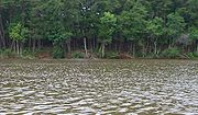
A river at risk
Starting in the early autumn months of 2007 the Catawba basin, along with large swaths of the Southern United StatesSouthern United States
The Southern United States—commonly referred to as the American South, Dixie, or simply the South—constitutes a large distinctive area in the southeastern and south-central United States...
, began to feel the effects of an extreme drought. On October 15, 2007, the Morganton News Herald reported that North Carolina
North Carolina
North Carolina is a state located in the southeastern United States. The state borders South Carolina and Georgia to the south, Tennessee to the west and Virginia to the north. North Carolina contains 100 counties. Its capital is Raleigh, and its largest city is Charlotte...
Governor Mike Easley
Mike Easley
Michael Francis "Mike" Easley is an American politician who served as the 72nd Governor of the U.S. state of North Carolina, from 2001 to 2009. He is member of the North Carolina Democratic Party and became the first North Carolina governor to admit to a felony in a deal that halted a lengthy...
described the drought as "the worst in recorded history".
On January 29, 2008, Duke Energy, the utility responsible for managing the Catawba River, extended its estimated time frame for Stage 4 water restrictions to August. The extension was possible because of conservation measures and the 6 inches of rain the basin received in December. However, area leaders converged on Valdese to hear presentations from Representatives of the N.C. Rural Center, N.C. Department of Commerce, N.C. Department of Environment and Natural Resources and the Appalachian Regional Commission about grants and loans that are available to help pay for solutions to the drought.
In April 2008 the environmental group American Rivers named the Catawba-Wateree River
Wateree River
The Wateree River, about 75 mi long, is a tributary of the Santee River in central South Carolina in the United States, which flows to the Atlantic Ocean...
"the most endangered river in America." The group's reasons cited for the river's condition are the drought, the presence of 11 hydroelectric dams, global warming
Global warming
Global warming refers to the rising average temperature of Earth's atmosphere and oceans and its projected continuation. In the last 100 years, Earth's average surface temperature increased by about with about two thirds of the increase occurring over just the last three decades...
, and unchecked development along its banks.
On June 11, 2008, South Carolina Governor Mark Sanford signed legislation denoting the Catawba as a state scenic river. The designation carries no land-use restrictions, but it does allow the state to convene an advisory group to address river-related concerns.
On June 29, 2009, the EPA announced that four of the top 44 "High Hazard Ash Ponds" in the United States are on the Catawba River. Two ash ponds are adjacent to and discharge into Mountain Island Lake
Mountain Island Lake
Mountain Island Lake was created in 1924 to coincide with the building of Mountain Island Hydroelectric Station. It is named after the mountain which appears as an island in the lake. Full pond elevation is approximately...
, and the EPA High Hazard list also includes ash ponds on Lake Wylie
Lake Wylie
Lake Wylie is a reservoir, or man-made lake in the U.S. states of both South Carolina and North Carolina. The lake has a surface area of and features of shore line.-History:...
and Lake Norman
Lake Norman
Lake Norman, created between 1959 and 1964 as part of the construction of the Cowans Ford Dam by Duke Energy, is the largest manmade body of fresh water located in North Carolina.-General Information:...
.
Crossings
The Catawba River is crossed by many highways over its course. (Note: this list may be incomplete)North Carolina
- Lake James to Lake Norman
- Power House Road
- Watermill Glen Alpine Road
- Independence Blvd in MorgantonMorganton, North CarolinaMorganton is a city in Burke County, North Carolina, United States. Reader's Digest included Morganton in its list of top ten places to raise a family. The town was recently profiled in The 50 Best Small Southern Towns. The population was 17,310 at the 2000 census...
- N Green Street (N.C. 181) in Morganton
- U.S. 64 in Morganton
- Huffman Bridge
- Castle Bridge near Rutherford CollegeRutherford College, North CarolinaRutherford College is a town in Burke County, North Carolina, in the United States. As of the 2000 census, the town population was 1,293. It is part of the Hickory–Lenoir–Morganton Metropolitan Statistical Area....
- Rhodhiss Road in RhodhissRhodhiss, North CarolinaRhodhiss is a town in Caldwell and Burke counties in the U.S. state of North Carolina. The population was 366 at the 2000 census. It is part of the Hickory–Lenoir–Morganton Metropolitan Statistical Area.-Geography:...
- U.S. 321 in HickoryHickory, North CarolinaHickory is a city in Catawba County, North Carolina. Hickory has the 162nd largest urban area in the United States. As of the 2000 census, the Metropolitan Statistical Area had a population of 341,851, making it the 4th largest metropolitan area in North Carolina. The city's population was 37,222...
- N.C. 127 near Hickory
- N.C. 16 below Oxford Dam
- Interstate 40Interstate 40Interstate 40 is the third-longest major east–west Interstate Highway in the United States, after I-90 and I-80. Its western end is at Interstate 15 in Barstow, California; its eastern end is at a concurrency of U.S. Route 117 and North Carolina Highway 132 in Wilmington, North Carolina...
- Hudson Chapel Road in CatawbaCatawbaCatawba may refer to several things:*Catawba , a Native American tribe*Catawban languages-Botany:*Catalpa, a genus of trees, based on the name used by the Catawba and other Native American tribes*Catawba , a variety of grape...
- US 70 in CatawbaCatawbaCatawba may refer to several things:*Catawba , a Native American tribe*Catawban languages-Botany:*Catalpa, a genus of trees, based on the name used by the Catawba and other Native American tribes*Catawba , a variety of grape...
- Buffalo Shoals Road over Lake NormanLake NormanLake Norman, created between 1959 and 1964 as part of the construction of the Cowans Ford Dam by Duke Energy, is the largest manmade body of fresh water located in North Carolina.-General Information:...
- N.C. 150 over Lake Norman
- Lake Norman to the SC border
- N.C. 73 bridge at Cowans Ford Dam
- Rozzelle Bridge on Brookshire Blvd (N.C. 16) over Mountain Island LakeMountain Island LakeMountain Island Lake was created in 1924 to coincide with the building of Mountain Island Hydroelectric Station. It is named after the mountain which appears as an island in the lake. Full pond elevation is approximately...
- E. Charlotte Avenue in Mount HollyMount Holly, North CarolinaMount Holly is a small suburban city in northeastern Gaston County, North Carolina, United States. The city is situated on the western bank of the Catawba River in the Southern Piedmont area of North Carolina, north of Interstate 85, south of North Carolina State Highway 16, and west of Charlotte....
- Interstate 85Interstate 85Interstate 85 is a major interstate highway in the Southeastern United States. Its current southern terminus is at an interchange with Interstate 65 in Montgomery, Alabama; its northern terminus interchanges with Interstate 95 in Petersburg, Virginia, near Richmond...
- Wilkinson Blvd U.S. 29 and U.S. 74 in BelmontBelmont, North CarolinaBelmont is a small suburban city in Gaston County, North Carolina, United States, located about west of uptown Charlotte, North Carolina and east of Gastonia. The population was 8,705 at the 2000 census. Once known as Garibaldi, the city named in honor of August Belmont, a prominent New York banker...
- Buster Boyd BridgeBuster Boyd BridgeThe Buster Boyd Bridge is a four-lane automobile bridge spanning Lake Wylie between Steele Creek in Mecklenburg County, North Carolina and the town of Lake Wylie in York County, South Carolina....
over Lake Wylie
South Carolina
- Lake Wylie to Lake Wateree
- Interstate 77Interstate 77Interstate 77 is an Interstate Highway in the eastern United States. It traverses diverse terrain, from the mountainous state of West Virginia to the rolling farmlands of North Carolina and Ohio. It largely supplants the old U.S...
between Rock HillRock Hill, South CarolinaRock Hill is the largest city in York County, South Carolina and the fourth-largest city in the state. It is also the third-largest city of the Charlotte metropolitan area, behind Charlotte and Concord, North Carolina. The population was 71,459 as of . Rock Hill has undergone rapid growth between...
and Ft. MillFort Mill, South CarolinaFort Mill is a fast-growing suburban town in both York and Lancaster counties in the U.S. state of South Carolina, and a suburb of the city of Charlotte, North Carolina, and Rock Hill... - Cherry Road U.S. 21 between Rock HillRock Hill, South CarolinaRock Hill is the largest city in York County, South Carolina and the fourth-largest city in the state. It is also the third-largest city of the Charlotte metropolitan area, behind Charlotte and Concord, North Carolina. The population was 71,459 as of . Rock Hill has undergone rapid growth between...
and Ft. MillFort Mill, South CarolinaFort Mill is a fast-growing suburban town in both York and Lancaster counties in the U.S. state of South Carolina, and a suburb of the city of Charlotte, North Carolina, and Rock Hill... - (Future) Dave Lyle Boulevard in Rock HillRock Hill, South CarolinaRock Hill is the largest city in York County, South Carolina and the fourth-largest city in the state. It is also the third-largest city of the Charlotte metropolitan area, behind Charlotte and Concord, North Carolina. The population was 71,459 as of . Rock Hill has undergone rapid growth between...
- Rock Hill Highway (S.C. 5) in CatawbaCatawba, South CarolinaCatawba is an unincorporated community in York County, South Carolina, United States along the Catawba River. The elevation of Catawba is 587 ft. and the Zip Code of Catawba is 29704.-References:*...
- Lancaster-Chester Highway (S.C. 9)
- Francis Avenue in Great FallsGreat Falls, South CarolinaGreat Falls is a town in Chester County, South Carolina, United States. The population was 2,194 at the 2000 census.-Geography and climate:Great Falls is located at ....
- Interstate 77