
List of National Natural Landmarks in New York
Encyclopedia
From List of National Natural Landmarks, these are the National Natural Landmark
s in New York State. There are 26 in total, X are lakes or pond, Y are forests, Z are other.
National Natural Landmark
The National Natural Landmark program recognizes and encourages the conservation of outstanding examples of the natural history of the United States. It is the only natural areas program of national scope that identifies and recognizes the best examples of biological and geological features in...
s in New York State. There are 26 in total, X are lakes or pond, Y are forests, Z are other.
| Name | Image | Date | Location | Description | |
|---|---|---|---|---|---|
| 1 | Bergen-Byron Swamp Bergen-Byron Swamp The Bergen-Byron Swamp is a protected swamp and nature preserve located in the towns of Byron and Bergen, New York. It is 400 million years old... |
Bergen Bergen (town), New York Bergen is a town in Genesee County, New York, United States. The town is in the northeast corner of the county. There is also a village of Bergen in the town... 43.091456°N 78.026533 °W |
A 2000 acres (8.1 km²) swamp that was the first National Natural Landmark National Natural Landmark The National Natural Landmark program recognizes and encourages the conservation of outstanding examples of the natural history of the United States. It is the only natural areas program of national scope that identifies and recognizes the best examples of biological and geological features in... to be designated. It is managed by the Bergen Swamp Preservation Society |
||
| 2 | Big Reed Pond Big Reed Pond Big Reed Pond in Montauk, Long Island in New York State is a freshwater pond that is mostly undeveloped. It was where the Montaukett tribe lived until the mid-19th century. It is a National Natural Landmark and is connected to Theodore Roosevelt County Park.There is a hiking trail open to the... |
Montauk Montauk, New York Montauk [ˈmɒntɒk] is a census-designated place that roughly corresponds to the hamlet with the same name located in the town of East Hampton in Suffolk County, New York, United States on the South Shore of Long Island. As of the United States 2000 Census, the CDP population was 3,851 as of 2000... 41.077701°N 71.910539°W |
An undeveloped fresh water lake where the Montaukett Montaukett The Montaukett is an Algonquian-speaking Native American group native to the eastern end of Long Island, New York and one of the thirteen historical indigenous centers... tribe lived until the mid-19th century. It is connected to Theodore Roosevelt County Park Theodore Roosevelt County Park Theodore Roosevelt County Park is located approximately east of Montauk, New York. The park is in size, running from Montauk Highway north to Block Island Sound and is bordered on the east by Montauk Point State Park... |
||
| 3 | Bear Swamp Preserve | Westerlo Westerlo, New York Westerlo is a town in Albany County, New York, United States. The population was 3,361 at the 2010 census.The town is on the south border of Albany County.- History :... 42.4742°N 74.0594°W |
A 310 acres (1.3 km²) Nature Conservancy The Nature Conservancy The Nature Conservancy is a US charitable environmental organization that works to preserve the plants, animals, and natural communities that represent the diversity of life on Earth by protecting the lands and waters they need to survive.... preserve including a pond and surrounding swamp and woodland. It is recognized for its Great Laurel tree population. |
||
| 4 | Deer Lick Nature Sanctuary Deer Lick Nature Sanctuary Deer Lick Nature Sanctuary in Cattaraugus County, New York is a protected forest and gorge in the Zoar Valley near Gowanda, New York. It was created by a donation from Miss Evelyn Alverson to the Nature Conservancy in 1960 with a further donation by Herbert F. Darling of Deer Lick Falls... |
Gowanda Gowanda, New York Gowanda is a village in New York in the United States and lies partly in Erie County and partly in Cattaraugus County. The population was 2,842 at the 2000 census. The name is a local native term meaning "almost surrounded by hills" or "beautiful place among the hills... 42.421045°N 78.905675°W |
A 398 acres (1.6 km²) Nature Conservancy preserve, 80 of which contain old growth forest. It is known for its wildlife and its gorges which highlight the Onondaga Escarpment. | ||
| 5 | Dexter Marsh Dexter Marsh Dexter Marsh is a wetland marsh located at the eastern end of Lake Ontario in Dexter, New York, and is a Wildlife Management Area. It is a popular fishing and trapping area as well as a migratory bird layover. Lacking barrier beaches, it is directly exposed to Lake Ontario's winds and waves. It... |
Dexter Dexter, New York Dexter is a village in Jefferson County, New York, United States. The population was 1,120 at the 2000 census. The name is derived from Simon Newton Dexter, one of the village's stockholders.... 43.98454°N 76.068478°W |
A 1350 acres (5.5 km²) wetland marsh located at the Eastern end of Lake Ontario Lake Ontario Lake Ontario is one of the five Great Lakes of North America. It is bounded on the north and southwest by the Canadian province of Ontario, and on the south by the American state of New York. Ontario, Canada's most populous province, was named for the lake. In the Wyandot language, ontarío means... . It is a popular fishing and trapping area as well as a migratory bird layover |
||
| 6 | Ellenville Fault-Ice Caves | Ellenville Ellenville, New York Ellenville is a village in Ulster County, New York, United States. The population was 4,135 at the 2010 census. The postal ZIP code is 12428. The telephone exchange is predominantly 647 and an overlaid 210 in the 845 area code.- Geography :... 41.671822°N 74.347486°W |
The largest open fault system in the United States results in ice caves which keeps ice year round and creates a cooler microclimate for more northern plants. Now part of Sam's Point Preserve Sam's Point Preserve Sam's Point Preserve, or Sam's Point Dwarf Pine Ridge Preserve, is a 4,600-acre preserve in Ulster County on the highest point of the Shawangunk Ridge in New York. It is owned by the Open Space Institute and managed by The Nature Conservancy. Its unique environment features dwarf pine trees... , run by the Nature Conservancy. |
||
| 7 | Fall Brook Gorge Fall Brook Gorge Fall Brook Gorge located in the Town of Geneseo, in Livingston County, New York, outside the Village of Geneseo, New York is an excellent example of Upper and Middle Devonian rock formations.... |
Geneseo Geneseo, New York Geneseo is the name of a town and its village in Livingston County in the Finger Lakes region of New York, USA, outside of Rochester, New York. The town's population is approximately 9,600, of which about 7,600 live in the village... 42.775456°N 77.82864°W |
An excellent example of Upper and Middle Devonian rock formations | ||
| 8 | Fossil Coral Reef Fossil Coral Reef Fossil Coral Reef, also known locally as Bradbury Quarry is a abandoned limestone quarry in Le Roy, New York. It contains a well preserved Middle Devonian coral reef along with rare tabulate and rugose corals, crinoids, gastropods, and trilobites.... |
Le Roy Le Roy (town), New York Le Roy, or more commonly LeRoy, is a town in Genesee County, New York, United States. The population was 7,790 at the 2000 census. The town is named after one of the original land owners, Herman Le Roy.... |
An abandoned limestone quarry, it contains a well preserved Middle Devonian coral reef Coral reef Coral reefs are underwater structures made from calcium carbonate secreted by corals. Coral reefs are colonies of tiny living animals found in marine waters that contain few nutrients. Most coral reefs are built from stony corals, which in turn consist of polyps that cluster in groups. The polyps... along with rare tabulate and rugose Rugose Rugose means "wrinkled". It may refer to:*Idiosoma nigrum, more commonly, a black rugose trapdoor spider*Rugosa, an extinct order of coral, whose rugose shape earned it the name... corals, crinoid Crinoid Crinoids are marine animals that make up the class Crinoidea of the echinoderms . Crinoidea comes from the Greek word krinon, "a lily", and eidos, "form". They live both in shallow water and in depths as great as 6,000 meters. Sea lilies refer to the crinoids which, in their adult form, are... s, gastropods, and trilobite Trilobite Trilobites are a well-known fossil group of extinct marine arthropods that form the class Trilobita. The first appearance of trilobites in the fossil record defines the base of the Atdabanian stage of the Early Cambrian period , and they flourished throughout the lower Paleozoic era before... s. |
||
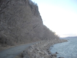
| 9 | Hook Mountain and Nyack Beach State Park |  |
Upper Nyack Upper Nyack, New York Upper Nyack is a village in the town of Clarkstown Rockland County, New York, United States located north of the village of Nyack; east of West Nyack; south of Rockland Lake State Park and west of the Hudson River. The population was 1,863 at the 2000 census.... 41.124°N 73.912°W |
A small state park known for its portion of the Palisades Sill Palisades Sill The Palisades Sill is a Triassic, 200 Ma diabase intrusion. It extends through portions of New York and New Jersey. It is most noteworthy for The Palisades, the cliffs that rise steeply above the western bank of the Hudson River... and its proximity to the Hudson River Hudson River The Hudson is a river that flows from north to south through eastern New York. The highest official source is at Lake Tear of the Clouds, on the slopes of Mount Marcy in the Adirondack Mountains. The river itself officially begins in Henderson Lake in Newcomb, New York... |
|
| 10 | Hart's Woods Hart's Woods Hart's Woods possibly also known as Beechwoods Park, is located in Perinton, New York. It contains a pristine stand of beech-maple forest, which covered 47% of Perinton prior to settlement... |
Perinton Perinton, New York Perinton is a town in Monroe County, New York, United States. The population was 46,090 at the 2000 census.The Village of Fairport, New York is within the town on the Erie Canal. Perinton is adjacent to the village of East Rochester , and the towns of Victor , Macedon , Pittsford , and Penfield... 43.097693°N 77.4119°W |
It contains a pristine stand of beech-maple forest Beech-maple forest A beech-maple forest is a climax mesic closed canopy hardwood forest. It is primarily composed of American Beech and Sugar Maple trees which co-dominate the forest and which are the pinnacle of plant succession in their range... , a climax Climax community In ecology, a climax community, or climatic climax community, is a biological community of plants and animals which, through the process of ecological succession — the development of vegetation in an area over time — has reached a steady state. This equilibrium occurs because the climax community... forest dominated by the American Beech American Beech Fagus grandifolia, also known as American Beech or North american beech, is a species of beech native to eastern North America, from Nova Scotia west to southern Ontario in southeastern Canada, west to Wisconsin and south to eastern Texas and northern Florida in the United States. Trees in the... and Sugar Maple Sugar Maple Acer saccharum is a species of maple native to the hardwood forests of northeastern North America, from Nova Scotia west to southern Ontario, and south to Georgia and Texas... which covered most of the Northeastern United States when it was settled. |
||
| 11 | Ironsides Island Ironsides Island Ironsides Island is a rocky island in the Saint Lawrence River, and part of the Thousand Islands region near Alexandria Bay, New York. It is in both Jefferson and St. Lawrence counties. It was donated by William Browning to the Nature Conservancy in the 1960s to serve as a rookery for Great blue... |
Alexandria Bay Alexandria Bay, New York Alexandria Bay is a village in Jefferson County, New York, United States. The population was 1,080 at the 2010 census.The Village of Alexandria Bay is in the Town of Alexandria.Keewaydin State Park is southeast of the village... 44.396111°N 75.850556°W |
This rocky island in the St Lawrence river is managed by the Nature Conservancy and serves as a rookery for Great blue herons | ||
| 12 | Iona Island Marsh | 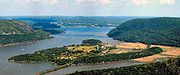 |
Stony Point Stony Point, New York Stony Point is a triangle-shaped town in Rockland County, United States. Rockland County is part of the New York Metropolitan Area. The town is located north of the town of Haverstraw, east and south of Orange County, New York, and west of the Hudson River and Westchester County. The population... 41.304°N 73.9773°W |
An island and marsh in the Hudson River Hudson River The Hudson is a river that flows from north to south through eastern New York. The highest official source is at Lake Tear of the Clouds, on the slopes of Mount Marcy in the Adirondack Mountains. The river itself officially begins in Henderson Lake in Newcomb, New York... which is a bird sanctuary and part of Bear Mountain State Park Bear Mountain State Park Bear Mountain State Park is located on the west side of the Hudson River in Orange and Rockland counties of New York. The park offers biking, hiking, boating, picnicking, swimming, cross-country skiing, cross-country running, sledding and ice skating... |
|
| 13 | Long Beach, Orient State Park |  |
Southold Southold, New York Southold is one of ten towns in Suffolk County, New York, United States. It is located in the northeastern tip of the county, on the North Fork of Long Island. The population was 20,599 at the 2000 census... 41.12937°N 72.2664°W |
This state park at the end of Long Island has a 2.5 miles (4 km) sand spit beach demonstrating plant succession from salt marsh Salt marsh A salt marsh is an environment in the upper coastal intertidal zone between land and salt water or brackish water, it is dominated by dense stands of halophytic plants such as herbs, grasses, or low shrubs. These plants are terrestrial in origin and are essential to the stability of the salt marsh... to maritime red cedar Juniperus virginiana Juniperus virginiana is a species of juniper native to eastern North America, from southeastern Canada to the Gulf of Mexico, east of the Great Plains... forest. |
|
| 14 | Lakeview Marsh and Barrier Beach | 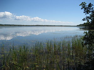 |
Ellisburg Ellisburg (town), New York Ellisburg is a town in Jefferson County, New York, United States. The population was 3,474 at the 2010 census. The town is in the southwestern corner of the county and is south of Watertown. Ellisburg is named after early landowners... 43.769°N 76.204°W |
Adjacent to Southwick Beach State Park Southwick Beach State Park Southwick Beach State Park is a New York State park that lies along an unusual stretch of sandy beach on the eastern shore of Lake Ontario. The park is in size with a length of beach, and is visited annually by about 100,000 people. Immediately to the south is the Lakeview Wildlife Management... , this 3461 acres (14 km²) marsh is protected by a barrier beach from Lake Ontario Lake Ontario Lake Ontario is one of the five Great Lakes of North America. It is bounded on the north and southwest by the Canadian province of Ontario, and on the south by the American state of New York. Ontario, Canada's most populous province, was named for the lake. In the Wyandot language, ontarío means... , unlike nearby Dexter Marsh Dexter Marsh Dexter Marsh is a wetland marsh located at the eastern end of Lake Ontario in Dexter, New York, and is a Wildlife Management Area. It is a popular fishing and trapping area as well as a migratory bird layover. Lacking barrier beaches, it is directly exposed to Lake Ontario's winds and waves. It... . |
|
| 15 | McLean Bogs McLean Bogs McLean Bogs is a small acidic kettle bog located in Dryden, New York. It contains several species of sphagnum moss and is approximately 70 meters wide and has a peat depth of 8 meters. It was donated to Cornell University by Curtis G. Lloyd in the 1930s. There are over 66 species of lichens in... |
Dryden Dryden, New York Dryden, New York can refer to:* Dryden , New York* Dryden , New York... |
A small acidic kettle bog managed by Cornell Plantations Cornell Plantations The Cornell Plantations are botanical gardens located adjacent to the Cornell University campus in Ithaca, New York. The Plantations proper consist of of botanical gardens and of the F.R. Newman Arboretum... which is part of Cornell University Cornell University Cornell University is an Ivy League university located in Ithaca, New York, United States. It is a private land-grant university, receiving annual funding from the State of New York for certain educational missions... . It is used for scientific research on the lichens and their methane gas production. |
||
| 16 | Mendon Ponds Park Mendon Ponds Park Mendon Ponds Park is a county park located southeast of Rochester, New York, within the suburban towns of Mendon and Pittsford. At over 2500 acres , it is the largest park in Monroe County... |
Mendon Mendon, New York Mendon is a town in Monroe County, New York, United States, and an affluent suburb of Rochester, New York. The population was 9,152 at the 2010 census.The Town of Mendon is on the south border of the county... 43.033333°N 77.566667°W |
A 2,500 acre (10 km²) county park known for its birdwatching and its unusual glacial geology, including kettle holes, esker Esker An esker is a long winding ridge of stratified sand and gravel, examples of which occur in glaciated and formerly glaciated regions of Europe and North America... s, kame Kame A kame is a geological feature, an irregularly shaped hill or mound composed of sand, gravel and till that accumulates in a depression on a retreating glacier, and is then deposited on the land surface with further melting of the glacier... s, and a floating sphagnum moss peat bog known as the Devils Bathtub. |
||
| 17 | Mianus River Gorge Mianus River Gorge The Mianus River Gorge is a nature preserve jointly owned by the Nature Conservancy and the Mianus River Gorge Preserve. It is located in Bedford, New York. The first were purchased by the Preserve, with help from the Conservancy, their first land preservation deal. It has grown over the... |
Bedford Bedford (town), New York Bedford is a town in Westchester County, New York, USA. The population was 17,335 at the 2010 census.The Town of Bedford is located in the northeastern part of Westchester County, and contains the three hamlets of Bedford Hills, Bedford Village, and Katonah... 41.185951°N 73.621394°W |
This preserve, known for its old growth climax Climax community In ecology, a climax community, or climatic climax community, is a biological community of plants and animals which, through the process of ecological succession — the development of vegetation in an area over time — has reached a steady state. This equilibrium occurs because the climax community... hemlock Eastern Hemlock Tsuga canadensis, also known as eastern or Canadian hemlock, and in the French-speaking regions of Canada as pruche du Canada, is a coniferous tree native to eastern North America. It ranges from northeastern Minnesota eastward through southern Quebec to Nova Scotia, and south in the Appalachian... forest and the Mianus River Mianus River The Mianus River is a river in Westchester County, New York and Fairfield County, Connecticut, in the United States. It begins in the town of North Castle, New York in a series of ponds at about altitude... was the first land purchase deal by the Nature Conservancy. |
||
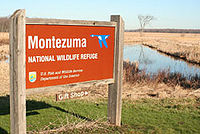
| 18 | Montezuma Marshes Montezuma National Wildlife Refuge Montezuma National Wildlife Refuge is a wildlife preserve operated by the United States Fish and Wildlife Service, encompassing part of the Montezuma Swamp at the north end of Cayuga Lake... |
 |
Seneca Falls Seneca Falls (town), New York Seneca Falls is a town in Seneca County, New York, United States. The population was 9,347 at the 2000 census.The Town of Seneca Falls contains a village also called Seneca Falls... 42.97°N 76.74°W |
A 7,000 acre (28 km²) wildlife preserve containing one of the best examples of undisturbed swamp woodlands in New York or New England. It is a major stop for migratory birds. | |
| 19 | Moss Island Moss Island Moss Island in Little Falls, New York is an igneous intrusion of Syenite in the Mohawk Valley with the Little Falls at one end. It became an island when locks were built so boats could avoid the 40 ft falls. It is known for its extremely large potholes as well as being popular with local rock... |
Little Falls Little Falls (city), New York Little Falls is a city in Herkimer County, New York, USA. The population was 5,188 at the 2000 census. The name is derived from a small cataract near the city.... 43.039771°N 74.848244°W |
An igneous intrusion Intrusion An intrusion is liquid rock that forms under Earth's surface. Magma from under the surface is slowly pushed up from deep within the earth into any cracks or spaces it can find, sometimes pushing existing country rock out of the way, a process that can take millions of years. As the rock slowly... in the Erie Canal Erie Canal The Erie Canal is a waterway in New York that runs about from Albany, New York, on the Hudson River to Buffalo, New York, at Lake Erie, completing a navigable water route from the Atlantic Ocean to the Great Lakes. The canal contains 36 locks and encompasses a total elevation differential of... with the Little Falls at one end. It became an island when locks were built so boats could avoid the 40 ft (12.2 m) falls. It is known for its extremely large (40–50 ft) glacial potholes created by retreating glaciers as well as being popular with local rock climbers. |
||
| 20 | Moss Lake Bogs | Houghton Houghton, New York Houghton is a hamlet located in the Town of Caneadea in Allegany County, New York. The population was 1,748 at the 2000 census.Houghton College is a private, coeducational college next to the hamlet.-Geography:... 42.398599°N 78.184687°W |
An 83 acres (335,889.4 m²) glacial kettle lake which filled with melt water and rain. Over time, sphagnum moss has grown over the open water, turning it into an acidic bog Bog A bog, quagmire or mire is a wetland that accumulates acidic peat, a deposit of dead plant material—often mosses or, in Arctic climates, lichens.... . It is managed by the Nature Conservancy. |
||
| 21 | Oak Orchard Creek Marsh | Medina Medina, New York Medina is a village in the towns of Shelby and Ridgeway in Orleans County, New York, United States. The population was 6,415 at the 2000 census, making it the second most populous municipality in the county after Albion, the county seat. The village was named by its surveyor... 43.135003°N 78.370886°W |
The marsh contains a state reserve, Oak Orchard Wildlife Management Area Oak Orchard Wildlife Management Area The Oak Orchard Wildlife Management Area is a conservation area located in western New York, USA. Most of this wildlife area is in the northwest part of Genesee County, but a small northern portion is in Orleans County.... , and a national reserve, the Iroquois National Wildlife Refuge Iroquois National Wildlife Refuge The Iroquois National Wildlife Refuge is a wildlife refuge operated by the United States Fish and Wildlife Service in Genesee and Orleans Counties in the western part of New York. The refuge is between the cities of Buffalo and Rochester.... , both of which are known as major stopover points for migratory birds. It was created by a partial blockage of the Oak Orchard River Oak Orchard River Oak Orchard Creek is a tributary of Lake Ontario in Orleans County, New York in the United States.Oak Orchard Creek rises south of Oak Orchard Creek Marsh at the border of Orleans and Genesee Counties... by glacial drift and an outcrop of limestone Limestone Limestone is a sedimentary rock composed largely of the minerals calcite and aragonite, which are different crystal forms of calcium carbonate . Many limestones are composed from skeletal fragments of marine organisms such as coral or foraminifera.... and dolostone Dolostone Dolostone or dolomite rock is a sedimentary carbonate rock that contains a high percentage of the mineral dolomite. In old U.S.G.S. publications it was referred to as magnesian limestone. Most dolostone formed as a magnesium replacement of limestone or lime mud prior to lithification. It is... known as the Lockport formation which forms the Niagara Escarpment Niagara Escarpment The Niagara Escarpment is a long escarpment, or cuesta, in the United States and Canada that runs westward from New York State, through Ontario, Michigan, Wisconsin and Illinois... . |
||
| 22 | Palisades of the Hudson |  |
Hudson River Hudson River The Hudson is a river that flows from north to south through eastern New York. The highest official source is at Lake Tear of the Clouds, on the slopes of Mount Marcy in the Adirondack Mountains. The river itself officially begins in Henderson Lake in Newcomb, New York... 40.964507°N 73.908591°W |
The line of dramatic 350 feet (106.7 m) cliffs of the Palisades Sill Palisades Sill The Palisades Sill is a Triassic, 200 Ma diabase intrusion. It extends through portions of New York and New Jersey. It is most noteworthy for The Palisades, the cliffs that rise steeply above the western bank of the Hudson River... along the west side of the lower Hudson River Hudson River The Hudson is a river that flows from north to south through eastern New York. The highest official source is at Lake Tear of the Clouds, on the slopes of Mount Marcy in the Adirondack Mountains. The river itself officially begins in Henderson Lake in Newcomb, New York... |
|
| 23 | Petrified Gardens |  |
Saratoga Springs Saratoga Springs, New York Saratoga Springs, also known as simply Saratoga, is a city in Saratoga County, New York, United States. The population was 26,586 at the 2010 census. The name reflects the presence of mineral springs in the area. While the word "Saratoga" is known to be a corruption of a Native American name, ... 43.083047°N 73.844489°W |
This private park preserves an area of ancient stromatolites in a fossilized ancient Cambrian Cambrian The Cambrian is the first geological period of the Paleozoic Era, lasting from Mya ; it is succeeded by the Ordovician. Its subdivisions, and indeed its base, are somewhat in flux. The period was established by Adam Sedgwick, who named it after Cambria, the Latin name for Wales, where Britain's... reef. Stromatolites "were first recognized, discovered, and interpreted in North America" here in 1922. The park, which is now closed, was a childhood inspiration for Stephen Jay Gould Stephen Jay Gould Stephen Jay Gould was an American paleontologist, evolutionary biologist, and historian of science. He was also one of the most influential and widely read writers of popular science of his generation.... . |
|
| 24 | Round Lake | _-_fayetteville_ny.jpg) |
Fayetteville Fayetteville, New York Fayetteville is a village located in Onondaga County, New York, United States. As of the 2000 U.S. Census, the village had a population of 4,190. The village is named after Lafayette, a national hero of both France and the United States... 43.049°N 75.973°W |
Part of Green Lakes State Park Green Lakes State Park Green Lakes State Park is a New York State Park located east of Syracuse in the Town of Manlius. The park is strikingly scenic, and has a "masterpiece" golf course designed by Robert Trent Jones very early in his career. Green Lake itself is perhaps the most studied meromictic lake – one in... , this lake is a rare meromictic Meromictic A meromictic lake has layers of water that do not intermix. In ordinary, "holomictic" lakes, at least once each year there is a physical mixing of the surface and the deep waters... lake is surrounded by a well preserved mesophytic forest Mesophyte Mesophytes are terrestrial plants which are adapted to neither a particularly dry nor particularly wet environment. An example of a mesophytic habitat would be a rural temperate meadow, which might contain Goldenrod, Clover, Oxeye Daisy, and Rosa multiflora.Mesophytes make up the largest ecological... |
|
| 25 | Thompson Pond Thompson Pond Thompson Pond in Pine Plains, New York is a 15,000-year-old glacial kettle pond at the foot of Stissing Mountain. It is the source of Wappingers Creek, a tributary of the Hudson River that drains much of Dutchess County.... |
Pine Plains 41.961118°N 73.678737 °W | A 75 acres (303,514.5 m²) glacial kettle pond and surrounding 507 acres (2.1 km²) nature preserve managed by the Nature Conservancy. It is the source of Wappingers Creek, a tributary of the Hudson River that drains much of Dutchess County.. It is known for its calcareous Calcareous Calcareous is an adjective meaning mostly or partly composed of calcium carbonate, in other words, containing lime or being chalky. The term is used in a wide variety of scientific disciplines.-In zoology:... bog Bog A bog, quagmire or mire is a wetland that accumulates acidic peat, a deposit of dead plant material—often mosses or, in Arctic climates, lichens.... , unlike other acidic bogs in the Northeast. |
||
| 26 | Zurich Bog Zurich Bog Zurich Bog is a sphagnum bog in Arcadia, New York. Lyman Stuart and the Newark School District donated the land on 10 December 1957 to the Bergen Swamp Preservation Society which had been created in 1935 to preserve the similar Bergen-Byron Swamp. The bog has had scientific interest since the... |
Arcadia Arcadia, New York Arcadia is a town in Wayne County, New York, United States. The population was 14,889 at the 2000 census.The Town of Arcadia is on the south border of the county and is east of Rochester NY.- History :The town was first settled around 1791.... 43.144648°N 77.050467°W |
A sphagnum Sphagnum Sphagnum is a genus of between 151 and 350 species of mosses commonly called peat moss, due to its prevalence in peat bogs and mires. A distinction is made between sphagnum moss, the live moss growing on top of a peat bog on one hand, and sphagnum peat moss or sphagnum peat on the other, the... bog Bog A bog, quagmire or mire is a wetland that accumulates acidic peat, a deposit of dead plant material—often mosses or, in Arctic climates, lichens.... managed by the Bergen Swamp Preservation Society |
||