

Southwick Beach State Park
Encyclopedia
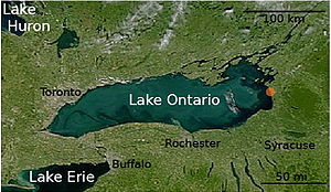
Lake Ontario
Lake Ontario is one of the five Great Lakes of North America. It is bounded on the north and southwest by the Canadian province of Ontario, and on the south by the American state of New York. Ontario, Canada's most populous province, was named for the lake. In the Wyandot language, ontarío means...
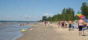
. The park is 464 acres (187.8 ha) in size with a 3500 feet (1,066.8 m) length of beach, and is visited annually by about 100,000 people. Immediately to the south is the Lakeview Wildlife Management Area
New York State Wildlife Management Areas
New York State owns and maintains more than 85 Wildlife Management Areas , with a total area of more than .The Wildlife Management Areas Program is administered by the Division of Fish, Wildlife and Marine Resources of the Department of Environmental Conservation...
(3461 acres (1,400.6 ha)), which extends the publicly accessible beach by several miles. They are in the Town of Ellisburg
Ellisburg (town), New York
Ellisburg is a town in Jefferson County, New York, United States. The population was 3,474 at the 2010 census. The town is in the southwestern corner of the county and is south of Watertown. Ellisburg is named after early landowners...
in Jefferson County, New York
Jefferson County, New York
Jefferson County is a county located in the U.S. state of New York. As of the 2010 census, the population was 116,229. It is named after Thomas Jefferson, third President of the United States of America, and president at the time the county was created in 1805...
south of the lakeside community of Jefferson Park.
The park offers an extensive campground with tent and trailer sites, picnic facilities, playing fields and a playground. In summer, the swimming area has lifeguards and the park store is open. In winter, snowmobiles are permitted in the park. The park has an accessible nature trail. There are hiking trails from the park that extend into the Lakeview Wildlife Management Area. Lakeview itself has several access points for launching boats, as well as a second nature trail along South Sandy Creek. The hiking trails and boat routes are described at several websites, and in guidebooks by William P. Ehling and by Susan Peterson Gateley.
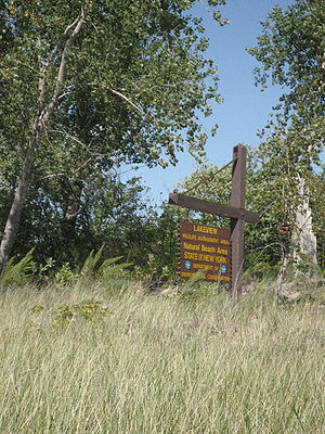
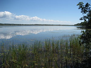
The park and wildlife management area lie within a rare, freshwater coastal barrier environment that consists of beaches, sand dunes, embayments and marsh
Marsh
In geography, a marsh, or morass, is a type of wetland that is subject to frequent or continuous flood. Typically the water is shallow and features grasses, rushes, reeds, typhas, sedges, other herbaceous plants, and moss....
es. The wildlife management area is also the Lakeview Marsh and Barrier Beach National Natural Landmark
National Natural Landmark
The National Natural Landmark program recognizes and encourages the conservation of outstanding examples of the natural history of the United States. It is the only natural areas program of national scope that identifies and recognizes the best examples of biological and geological features in...
, which was cited in 1973 as, "One of the best and most extensive marshlands that lie in protected bays and behind barrier beaches along eastern Lake Ontario." Southwick Beach State Park and Lakeview Wildlife Management Area are included as parts of a proposed New York State Natural Heritage Area entitled "Eastern Lake Ontario Barrier Beach and Wetland Complex".
Beachgrass & the dunes
Ammophila breviligulata
Ammophila breviligulata is a species of grass that is native to eastern North America, where it grows on sand dunes along the Atlantic Ocean and Great Lakes coasts...
. The beachgrass grows runners under the surface of the sand that interlock into a ropelike network, and actually builds the dune by trapping sand. Some tall wormwood
Artemisia campestris
Artemisia campestris L. is a species of herbaceous biennial or perennial plants in the genus Artemisia that grows in open sites on dry sandy soils throughout the Boreal Kingdom.-External links:** in Flora of North America...
plants grow amidst the beachgrass, as do cottonwood trees and sand dune willow
Salix cordata
Salix cordata is a perennial shrub that grows tall; plants taller than are rare. The plant is native to the northeast regions of the North American continent; it is found on sand dunes, river banks, and lake shores in sandy, silty or gravelly soils....
s. Cottonwood is the only dune-forming tree in the area. Sand dune willows are fairly rare in New York State, but are a common woody plant in these dunes. This "beachgrass plant community" stabilizes the dunes against erosion by wind and storm, and enables the growth of a more complex, "poison ivy
Poison ivy
Toxicodendron radicans, better known as poison ivy , is a poisonous North American plant that is well known for its production of urushiol, a clear liquid compound found within the sap of the plant that causes an itching rash in most people who touch it...
-dune grape
Vitis riparia
Vitis riparia Michx, also commonly known as River Bank Grape or Frost Grape, is a native American climbing or trailing vine, widely distributed from Quebec to Texas, and Montana to New England. It is long-lived and capable of reaching into the upper canopy of the tallest trees...
-cottonwood plant community" deeper in the dunes.
Beachgrass growth is disrupted by human and animal traffic. In heavily used regions of the eastern Lake Ontario dunes, foot traffic has eliminated this plant community entirely. Without the beachgrass, the sand dunes are blown away by wind. Starting in the early 1990s, there has been extensive restoration of the beachgrass along eastern Lake Ontario. Wooden "walkovers" have been constructed to manage traffic across the dunes between the beach and interior trails and waterways. The restoration has been accompanied by education and outreach programs intended to reduce traffic across the dunes. The improvement in beachgrass growth has been documented by a "photomonitoring project" from 1995-2005.
Until the 20th Century, the beachgrass in this region would have been the type now known as "Champlain beachgrass", which is found only along eastern Lake Ontario and along Lake Champlain
Lake Champlain
Lake Champlain is a natural, freshwater lake in North America, located mainly within the borders of the United States but partially situated across the Canada—United States border in the Canadian province of Quebec.The New York portion of the Champlain Valley includes the eastern portions of...
. It is very similar to the common American beachgrass native to the Atlantic coasts of North America, but blooms in July instead of September. "Cape variety" American beachgrass was introduced into the area, and is now mixed with Champlain.
Boogie, baseball, and beaches: the Southwick history
Southwick Beach State Park was named after the Southwick family, who owned the property for nearly a century (1870 to 1960); the park is referred to as "Southwick's Beach State Park" on some maps. Starting in the 1920s, several promoters built entertainment facilities on the property. The most notable was Albert Ellis, who leased the beach from the Southwick family for about 15 years, and developed it as the "Coney Island" of Northern New York. In time, the beach boasted a roller coaster, bathhouses, a dance pavilion, merry go-round, and midway. Ellis also organized the Jefferson County Amateur Baseball League. A baseball diamond was built at Southwick Beach, and for several years there was a Southwick Beach team. These businesses failed during the Great DepressionGreat Depression
The Great Depression was a severe worldwide economic depression in the decade preceding World War II. The timing of the Great Depression varied across nations, but in most countries it started in about 1929 and lasted until the late 1930s or early 1940s...
.
By the 1950s, the value of the eastern Lake Ontario shoreline for recreation and conservation was becoming clear, although little of this land was publicly owned. In 1960, the Leesi Management Corporation of Syracuse purchased the beach property from the Southwick family and operated the beach as a recreational facility for five years. The New York State Office of Parks, Recreation and Historic Preservation purchased the property in 1965 for $150,000; Southwick Beach State Park opened in May, 1966.
Lagoons and sand: geology of eastern Lake Ontario
Sandbanks Provincial Park
Sandbanks Provincial Park is a provincial park located on Lake Ontario in Prince Edward County near Picton, Ontario, Canada. It is noted for its picturesque sand dunes and beaches. It also has the world's largest fresh water sand bar and dune system.Sandbanks is run...
in Prince Edward County, Ontario
Prince Edward County, Ontario
Prince Edward County is a single-tier municipality and a census division of the Canadian province of Ontario.-Geography:Prince Edward County is located in Southern Ontario on a large irregular headland or littoral at the eastern end of Lake Ontario, just west of the head of the St. Lawrence River...
, Canada, which is along the northeastern shore of the lake. These are the main areas with sandy beaches on Lake Ontario.
Bradford B. van Diver has described the eastern Lake Ontario dunes as "similar in many details to the south shore of Long Island, with drowned river mouths forming lagoons behind a smooth curving line of barrier bars." The lagoons to which van Diver refers are the notable ponds of this region, including (from north to south) Black, Lakeview, North Sandy, and South Sandy. Both the rivers themselves, and their mouths, are no longer evident. Shortly after the cessation of the last ice age about 10,000 years ago, the water level of Lake Ontario was much lower than it is today; one needs to envision large rivers flowing into a lake some tens of meters lower than today's level. The river mouths were then "drowned" by the rise of the water level of Lake Ontario above this low point. Similarly, sand itself is no longer being formed in abundance; the sand present on today's beaches was probably formed long ago, and transported down from higher elevations during the post-glacial period of low water levels in the lake.
External links (including park contact information)
Official webpage for Southwich Beach State Park that includes a link for camping reservations as well as contact information for the park. Official webpage for Lakeview Wildlife Management Area.- New York State Department of Environmental Conservation (2005). "Map of Southwick Beach State Park and Lakeview Wildlife Management Area", archived at WebCite from this original URL 2008-04-22.