
,_new_york.gif)
Bergen (town), New York
Encyclopedia
Bergen is a town in Genesee County
, New York
, United States
. The town is in the northeast corner of the county. There is also a village of Bergen
in the town. The population was 3,182 at the 2000 census.
The town of Bergen was part of the Triangle Tract and the 100,000 Acre Tract (or the Connecticut Tract) in the Morris Reserve. It is a portion of the triangular tract sold to Le Roy and others from the Morris Reserve; and it contains two tiers of lots from the Connecticut tract. The latter are in the western part of the town. The community was named for the city in Norway.
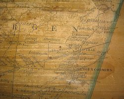
 The Bergen area was opened up in 1801 when a road was hacked through the thick "Northwoods" (In its early days of settlement, Bergen was called Northwoods.) from LeRoy to Lake Ontario. Bergen was first settled in 1801 by Samuel Lincoln. In the same year George Letson, William Letson, Benajah Worden, Richard Abbey, Solomon Levi, Jesse Leach, James Letson, Gideon Elliott and David Scott settled in town. A colony of 60 families from the State of Connecticut settled the area along Route 19 from Fort Hill (near Parmalee Rd) to Black Creek from 1805-1810. The first store was a mile south of Route 33 on Route 19 on the east side of the road. The first group of stores was located from the intersection of Lake Rd. (rt. 19) and Route 262 to the intersection of Rt. 19 and the Scottsville Road (Rt.33A). This area was called Buell's Corner, later Bergen Corners or High Bergen. The first church organization was established in December, 1807. The Congregational church was founded January 25, 1808. Harry Kelsey, a graduate of Yale college, taught the first school. The first frame house in the town was erected by Dr. Levi Ward, the pioneer physician. Jared Merritt built the first saw mill. Dr. Ward was also proprietor of the first store, in 1808. The first inn was opened in 1809 by Samuel Butler. Colonel W. H. Ward was the first postmaster.
Bergen was erected from the town of Murray (which was divided into three towns) on April 2, 1813. It was also part of the town of Northampton. Byron was part of Bergen until 1820.
In 1820, part of Bergen was used to form the town of Byron
.
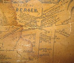
After the railroad came through in 1836, an area was laid out around the intersection of Lake Road (Route 19) and the railroad for businesses and houses. It was called Wardville after the Levi Ward family who laid it out. It was also called Cork, after the Irish who settled there while and after the building of the railroad, and Lower Bergen. The two areas were soon connected by residences and churches.
Fire initially destroyed the business area around the railroad tracks in 1866.
This area, along with the surrounding residences was incorporated in on March 5, 1877 as the village of Bergen. The village of Bergen is located near the center of the eastern boundary line, on the New York Central and Hudson River Railroad.
Fire destroyed the business area around the railroad tracks again in 1880. The Village Board passed an ordinance requiring that all structures in this area should be built of brick or stone or wrought iron.
The west side of the district south of the railroad is on the National Register due to its 1880 wrought iron store fronts, transom windows and probably, also, because of the famous family who founded "Wardville". Some of the family went on from Bergen to the Rochester area and were also primary developers of that area.
Due to the building material and better fire fighting equipment, another in 1906 destroyed only some of the buildings on the west side of the street. A fire in 1932 leveled some of the buildings on the east side of the street. Since then fires in individual buildings have caused some alteration of the facade of the buildings.
When glaciers of the fourth ice age retreated from the northeast corner of New York State 125,000 years ago, they left behind 2000 acres (8.1 km²) of forested wetlands now known as the Bergen Swamp. The three-mile (5 km) long wildlife area is home to dozens of species of unusual birds, reptiles and rare flowers that thrive in an undisturbed, natural environment.
, the town has a total area of 27.6 square miles (71.6 km²), of which, 27.6 square miles (71.6 km²) of it is land and 0.04% is water.
Bergen Swamp, a glacial
feature now kept as a wildlife preserve, is home to a small endangered rattlesnake
, the Eastern Massasauga, as well as a large diversity
of other species.
The eastern town line is the border of Monroe County
, New York and the northern town line is the border of both Monroe County and Orleans County
, New York.
Interstate 490
passes through the southeast part of the town.
of 2000, there were 3,182 people, 1,196 households, and 857 families residing in the town. The population density
was 115.2 people per square mile (44.5/km²). There were 1,240 housing units at an average density of 44.9 per square mile (17.3/km²). The racial makeup of the town was 97.27% White, 0.31% Black or African American
, 0.25% Native American, 0.50% Asian, 0.79% from other races
, and 0.88% from two or more races. Hispanic or Latino of any race were 1.01% of the population.
There were 1,196 households out of which 34.2% had children under the age of 18 living with them, 61.8% were married couples
living together, 5.6% had a female householder with no husband present, and 28.3% were non-families. 21.8% of all households were made up of individuals and 9.7% had someone living alone who was 65 years of age or older. The average household size was 2.66 and the average family size was 3.14.
In the town the population was spread out with 26.6% under the age of 18, 7.3% from 18 to 24, 30.7% from 25 to 44, 23.6% from 45 to 64, and 11.8% who were 65 years of age or older. The median age was 37 years. For every 100 females there were 102.9 males. For every 100 females age 18 and over, there were 101.6 males.
The median income for a household in the town was $49,412, and the median income for a family was $54,012. Males had a median income of $36,913 versus $26,571 for females. The per capita income
for the town was $20,932. About 1.6% of families and 4.1% of the population were below the poverty line, including 2.8% of those under age 18 and 7.3% of those age 65 or over.
Genesee County, New York
Genesee County is a county located in Western New York, United States. As of the 2010 census, the population was 60,079. Its name is from the Seneca Indian word Gen-nis'-hee-yo meaning "The Beautiful Valley." Its county seat is Batavia.- History :...
, New York
New York
New York is a state in the Northeastern region of the United States. It is the nation's third most populous state. New York is bordered by New Jersey and Pennsylvania to the south, and by Connecticut, Massachusetts and Vermont to the east...
, United States
United States
The United States of America is a federal constitutional republic comprising fifty states and a federal district...
. The town is in the northeast corner of the county. There is also a village of Bergen
Bergen (village), New York
Bergen is a village in Genesee County, New York, United States. The population was 1,240 at the 2000 census.The village lies on the eastern edge of the Town of Bergen. The village is north of the junction of Routes 19 and 33.-History:...
in the town. The population was 3,182 at the 2000 census.
History
Bergen is the second smallest town in Genesee County, New York.The town of Bergen was part of the Triangle Tract and the 100,000 Acre Tract (or the Connecticut Tract) in the Morris Reserve. It is a portion of the triangular tract sold to Le Roy and others from the Morris Reserve; and it contains two tiers of lots from the Connecticut tract. The latter are in the western part of the town. The community was named for the city in Norway.
Bergen was erected from the town of Murray (which was divided into three towns) on April 2, 1813. It was also part of the town of Northampton. Byron was part of Bergen until 1820.
In 1820, part of Bergen was used to form the town of Byron
Byron, New York
Byron is a town in Genesee County, New York, United States. It was named in honor of Lord Byron. The town is on the northern border of the county, and lies northeast of the city of Batavia. The population was 2,493 at the 2000 census. The local school district, Byron-Bergen Central School District...
.
After the railroad came through in 1836, an area was laid out around the intersection of Lake Road (Route 19) and the railroad for businesses and houses. It was called Wardville after the Levi Ward family who laid it out. It was also called Cork, after the Irish who settled there while and after the building of the railroad, and Lower Bergen. The two areas were soon connected by residences and churches.
Fire initially destroyed the business area around the railroad tracks in 1866.
This area, along with the surrounding residences was incorporated in on March 5, 1877 as the village of Bergen. The village of Bergen is located near the center of the eastern boundary line, on the New York Central and Hudson River Railroad.
Fire destroyed the business area around the railroad tracks again in 1880. The Village Board passed an ordinance requiring that all structures in this area should be built of brick or stone or wrought iron.
The west side of the district south of the railroad is on the National Register due to its 1880 wrought iron store fronts, transom windows and probably, also, because of the famous family who founded "Wardville". Some of the family went on from Bergen to the Rochester area and were also primary developers of that area.
Due to the building material and better fire fighting equipment, another in 1906 destroyed only some of the buildings on the west side of the street. A fire in 1932 leveled some of the buildings on the east side of the street. Since then fires in individual buildings have caused some alteration of the facade of the buildings.
When glaciers of the fourth ice age retreated from the northeast corner of New York State 125,000 years ago, they left behind 2000 acres (8.1 km²) of forested wetlands now known as the Bergen Swamp. The three-mile (5 km) long wildlife area is home to dozens of species of unusual birds, reptiles and rare flowers that thrive in an undisturbed, natural environment.
Geography
According to the United States Census BureauUnited States Census Bureau
The United States Census Bureau is the government agency that is responsible for the United States Census. It also gathers other national demographic and economic data...
, the town has a total area of 27.6 square miles (71.6 km²), of which, 27.6 square miles (71.6 km²) of it is land and 0.04% is water.
Bergen Swamp, a glacial
Ice age
An ice age or, more precisely, glacial age, is a generic geological period of long-term reduction in the temperature of the Earth's surface and atmosphere, resulting in the presence or expansion of continental ice sheets, polar ice sheets and alpine glaciers...
feature now kept as a wildlife preserve, is home to a small endangered rattlesnake
Rattlesnake
Rattlesnakes are a group of venomous snakes of the genera Crotalus and Sistrurus of the subfamily Crotalinae . There are 32 known species of rattlesnake, with between 65-70 subspecies, all native to the Americas, ranging from southern Alberta and southern British Columbia in Canada to Central...
, the Eastern Massasauga, as well as a large diversity
Biodiversity
Biodiversity is the degree of variation of life forms within a given ecosystem, biome, or an entire planet. Biodiversity is a measure of the health of ecosystems. Biodiversity is in part a function of climate. In terrestrial habitats, tropical regions are typically rich whereas polar regions...
of other species.
The eastern town line is the border of Monroe County
Monroe County, New York
Monroe County is a county located in the U.S. state of New York. As of the 2010 census, the population was 744,344. It is named after James Monroe, fifth President of the United States of America. Its county seat is the city of Rochester....
, New York and the northern town line is the border of both Monroe County and Orleans County
Orleans County, New York
As of the census of 2000, there were 44,171 people, 15,363 households, and 10,846 families residing in the county. The population density was 113 people per square mile . There were 17,347 housing units at an average density of 44 per square mile...
, New York.
Interstate 490
Interstate 490 (New York)
Interstate 490 is an auxiliary Interstate Highway that serves the city of Rochester, New York, in the United States. It acts as a northerly alternate route to the New York State Thruway , leaving it at exit 47 in the town of Le Roy and rejoining the highway at exit 45 in the town of...
passes through the southeast part of the town.
Demographics
As of the censusCensus
A census is the procedure of systematically acquiring and recording information about the members of a given population. It is a regularly occurring and official count of a particular population. The term is used mostly in connection with national population and housing censuses; other common...
of 2000, there were 3,182 people, 1,196 households, and 857 families residing in the town. The population density
Population density
Population density is a measurement of population per unit area or unit volume. It is frequently applied to living organisms, and particularly to humans...
was 115.2 people per square mile (44.5/km²). There were 1,240 housing units at an average density of 44.9 per square mile (17.3/km²). The racial makeup of the town was 97.27% White, 0.31% Black or African American
Race (United States Census)
Race and ethnicity in the United States Census, as defined by the Federal Office of Management and Budget and the United States Census Bureau, are self-identification data items in which residents choose the race or races with which they most closely identify, and indicate whether or not they are...
, 0.25% Native American, 0.50% Asian, 0.79% from other races
Race (United States Census)
Race and ethnicity in the United States Census, as defined by the Federal Office of Management and Budget and the United States Census Bureau, are self-identification data items in which residents choose the race or races with which they most closely identify, and indicate whether or not they are...
, and 0.88% from two or more races. Hispanic or Latino of any race were 1.01% of the population.
There were 1,196 households out of which 34.2% had children under the age of 18 living with them, 61.8% were married couples
Marriage
Marriage is a social union or legal contract between people that creates kinship. It is an institution in which interpersonal relationships, usually intimate and sexual, are acknowledged in a variety of ways, depending on the culture or subculture in which it is found...
living together, 5.6% had a female householder with no husband present, and 28.3% were non-families. 21.8% of all households were made up of individuals and 9.7% had someone living alone who was 65 years of age or older. The average household size was 2.66 and the average family size was 3.14.
In the town the population was spread out with 26.6% under the age of 18, 7.3% from 18 to 24, 30.7% from 25 to 44, 23.6% from 45 to 64, and 11.8% who were 65 years of age or older. The median age was 37 years. For every 100 females there were 102.9 males. For every 100 females age 18 and over, there were 101.6 males.
The median income for a household in the town was $49,412, and the median income for a family was $54,012. Males had a median income of $36,913 versus $26,571 for females. The per capita income
Per capita income
Per capita income or income per person is a measure of mean income within an economic aggregate, such as a country or city. It is calculated by taking a measure of all sources of income in the aggregate and dividing it by the total population...
for the town was $20,932. About 1.6% of families and 4.1% of the population were below the poverty line, including 2.8% of those under age 18 and 7.3% of those age 65 or over.
Communities and locations in the Town of Bergen
- BergenBergen (village), New YorkBergen is a village in Genesee County, New York, United States. The population was 1,240 at the 2000 census.The village lies on the eastern edge of the Town of Bergen. The village is north of the junction of Routes 19 and 33.-History:...
– A village in the eastern part of the town on Route 19. - East Bergen – A hamlet on Route 19 in the northeast corner of the town.
- Jerico Corners – A location at the intersection of Jerico and Swamp Roads.
- Little Boston
- North BergenNorth Bergen, New YorkNorth Bergen, New York is an unincorporated hamlet in the town of Bergen in Genesee County, New York, USA.-References:...
– A hamlet in the northwest corner of the town. - Sheepskin Corners
- Stone Church – A hamlet south of Bergen village on Route 19.
- West Bergen – A hamlet near the western town line.
- West Sweden