
List of National Historic Landmarks in Arizona
Encyclopedia
This is a List of National Historic Landmarks in Arizona. There are 41 National Historic Landmarks (NHLs) in Arizona, counting Hoover Dam
which spans from Nevada and is listed in Nevada by the National Park Service
(NPS), and Yuma Crossing and Associated Sites
, which is listed by the NPS in Arizona, but also overlaps into California. The first designated was San Xavier del Bac Mission, in October, 1960. The most recently designated is Sage Memorial Hospital School of Nursing
, in January, 2009.
Following is a complete list:
Hohokam Pima National Monument
, Fort Bowie National Historic Site, and Hubbell Trading Post National Historic Site
are also NHLs and are listed above. The other 11 are:
Hoover Dam
Hoover Dam, once known as Boulder Dam, is a concrete arch-gravity dam in the Black Canyon of the Colorado River, on the border between the US states of Arizona and Nevada. It was constructed between 1931 and 1936 during the Great Depression and was dedicated on September 30, 1935, by President...
which spans from Nevada and is listed in Nevada by the National Park Service
National Park Service
The National Park Service is the U.S. federal agency that manages all national parks, many national monuments, and other conservation and historical properties with various title designations...
(NPS), and Yuma Crossing and Associated Sites
Yuma Crossing and Associated Sites
Yuma Crossing is a site in Arizona and California that is significant for its association with transportation and communication across the Colorado River. It connected New Spain and Las Californias in the Spanish Colonial period in and also during the Western expansion of the United States. ...
, which is listed by the NPS in Arizona, but also overlaps into California. The first designated was San Xavier del Bac Mission, in October, 1960. The most recently designated is Sage Memorial Hospital School of Nursing
Sage Memorial Hospital School of Nursing
Sage Memorial Hospital School of Nursing in Ganado, Arizona was designated a U.S. National Historic Landmark on January 16, 2008.The press release read:...
, in January, 2009.
Following is a complete list:
Current NHLs
| Landmark name | Image | Date designated | Locality | County | Description | |
|---|---|---|---|---|---|---|
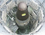
| Air Force Facility Missile Site 8 | 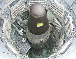 |
Green Valley Green Valley, Arizona Green Valley is a census-designated place in Pima County, Arizona, United States. The population was 17,283 at the 2000 census.-Geography:Green Valley is located at .... 31.901339435°N 110.998413644°W |
Pima Pima County, Arizona -2010:Whereas according to the 2010 U.S. Census Bureau:*74.3% White*3.5% Black*3.3% Native American*2.6% Asian*0.2% Native Hawaiian or Pacific Islander*3.7% Two or more races*12.4% Other races*34.6% Hispanic or Latino -2000:... |
Last surviving Titan II missile launch facility; inactive | ||
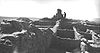
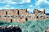
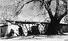
| Awatovi Ruins Awatovi Ruins Awatovi Ruins is a National Historic Landmark in Navajo County, Arizona, United States, designated in 1964. In 1540, Coronado's men visited this village. What remains are the ruins of a five hundred year old pueblo. There are also ruins from a Spanish mission built in the 17th century... |
 |
Keams Canyon Keams Canyon, Arizona Keams Canyon is a census-designated place in Navajo County, Arizona, United States. The population was 260 at the 2000 census.-Geography:Keams Canyon is located at .... |
Navajo Navajo County, Arizona -2010:Whereas according to the 2010 U.S. Census Bureau:*49.3% White*0.9% Black*43.4% Native American*0.5% Asian*0.1% Native Hawaiian or Pacific Islander*2.5% Two or more races*3.3% Other races*10.8% Hispanic or Latino -2000:... |
Ruins of a 500 year old pueblo visited by Coronado's men in 1540 | ||
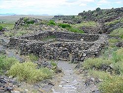
| Casa Malpais Site Casa Malpais Casa Malpaís is an ancient pueblo people archaeological site located near the town of Springerville, Arizona. The site is a nationally recognized archaeological site and was declared a National Historic Landmark in 1964.-Description:... |
 |
Springerville Springerville, Arizona Springerville is a town in Apache County, Arizona, United States within the White Mountains. Its postal ZIP code is 85938. According to 2006 Census Bureau estimates, the population of the town is 1,956.Springerville sits at an elevation of 6,974 feet... |
Apache Apache County, Arizona -2010:Whereas according to the 2010 U.S. Census Bureau:*23.3% White*0.2% Black*72.9% Native American*0.3% Asian*0.0% Native Hawaiian or Pacific Islander*2.0% Two or more races*1.3% Other races*5.8% Hispanic or Latino -2000:... |
Ruin built around 1250 A.D.; inhabited until about 1440 A.D | ||
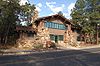
| Mary Jane Colter Buildings Mary Jane Colter Buildings The Mary Jane Colter Buildings are four structures at Grand Canyon National Park designed by Mary Colter:* Hermit's Rest* Desert View Watchtower* Lookout Studio, also known as The Lookout* Hopi House... |
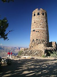 |
South Rim locations in Grand Canyon National Park Grand Canyon National Park Grand Canyon National Park is the United States' 15th oldest national park and is located in Arizona. Within the park lies the Grand Canyon, a gorge of the Colorado River, considered to be one of the Wonders of the World. The park covers of unincorporated area in Coconino and Mohave counties.Most... |
Coconino Coconino County, Arizona -2010:Whereas according to the 2010 U.S. Census Bureau:*61.7% White*1.2% Black*27.3% Native American*1.4% Asian*0.1% Native Hawaiian or Pacific Islander*3.1% Two or more races*5.2% Other races*13.5% Hispanic or Latino -2000:... |
Includes:
|
||
| Desert Laboratory Desert Laboratory The Desert Laboratory at 1675 West Anklam Road, Tucson, Arizona was founded by the Carnegie Institution in 1903 to better understand how plants adapted to arid desert environments. Numerous long term ecological experiments were created on the around Tumamoc Hill... |
 |
Tucson Tucson, Arizona Tucson is a city in and the county seat of Pima County, Arizona, United States. The city is located 118 miles southeast of Phoenix and 60 miles north of the U.S.-Mexico border. The 2010 United States Census puts the city's population at 520,116 with a metropolitan area population at 1,020,200... 32.225278°N 111.0025°W |
Pima Pima County, Arizona -2010:Whereas according to the 2010 U.S. Census Bureau:*74.3% White*3.5% Black*3.3% Native American*2.6% Asian*0.2% Native Hawaiian or Pacific Islander*3.7% Two or more races*12.4% Other races*34.6% Hispanic or Latino -2000:... |
Founded in 1903 to study plant adaptation to an arid desert environment with long term experiments, this laboratory contributed significantly to the formation of Ecology Ecology Ecology is the scientific study of the relations that living organisms have with respect to each other and their natural environment. Variables of interest to ecologists include the composition, distribution, amount , number, and changing states of organisms within and among ecosystems... as a science. Part of the University of Arizona University of Arizona The University of Arizona is a land-grant and space-grant public institution of higher education and research located in Tucson, Arizona, United States. The University of Arizona was the first university in the state of Arizona, founded in 1885... |
||
| Double Adobe Site Double Adobe Site The Double Adobe Site is an archaeological site in southern Arizona, twelve miles northwest of Douglas in the Whitewater Draw area. In October 1926, just three months after the first human artifact was uncovered at the Folsom Site, Byron Cummings, first Head of the Archaeology Department at the... |
image pending | Douglas Douglas, Arizona Douglas is a city in Cochise County, Arizona, United States. Douglas has a border crossing with Mexico and a history of mining.The population was 14,312 at the 2000 census... |
Cochise Cochise County, Arizona -2010:Whereas according to the 2010 U.S. Census Bureau:*78.5% White*4.2% Black*1.2% Native American*1.9% Asian*0.3% Native Hawaiian or Pacific Islander*4.0% Two or more races*9.6% Other races*32.4% Hispanic or Latino -2000:... |
Archaeological site where development of the Cochise Culture occurred | ||
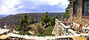
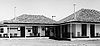
| El Tovar Hotel El Tovar Hotel The El Tovar Hotel, also known simply as El Tovar, is a former Harvey House hotel situated directly on the south rim of the Grand Canyon in Arizona, USA... |
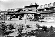 |
Grand Canyon Village Grand Canyon Village, Arizona Grand Canyon Village is a census-designated place located on the South Rim of the Grand Canyon, in Coconino County, Arizona. Its population was 1,460 at the 2000 Census. Located in Grand Canyon National Park, it is wholly focused on accommodating tourists visiting the canyon... 36.0557044314°N 112.136999169°W |
Coconino Coconino County, Arizona -2010:Whereas according to the 2010 U.S. Census Bureau:*61.7% White*1.2% Black*27.3% Native American*1.4% Asian*0.1% Native Hawaiian or Pacific Islander*3.1% Two or more races*5.2% Other races*13.5% Hispanic or Latino -2000:... |
Classic lodge at South Rim of Grand Canyon | ||
| Fort Bowie National Historic Site | Bowie Bowie, Arizona Bowie is an unincorporated community in Cochise County, Arizona. The community lies on Interstate 10 in eastern Arizona close to the western New Mexico border... |
Cochise Cochise County, Arizona -2010:Whereas according to the 2010 U.S. Census Bureau:*78.5% White*4.2% Black*1.2% Native American*1.9% Asian*0.3% Native Hawaiian or Pacific Islander*4.0% Two or more races*9.6% Other races*32.4% Hispanic or Latino -2000:... |
Commemorates the conflict between the Chiricahua Apaches and the United States military; preserves the ruins of Fort Bowie | |||
| Fort Huachuca Fort Huachuca Fort Huachuca is a United States Army installation under the command of the United States Army Installation Management Command. It is located in Cochise County, in southeast Arizona, about north of the border with Mexico. Beginning in 1913, for 20 years the fort was the base for the "Buffalo... |
 |
Sierra Vista Sierra Vista, Arizona Sierra Vista is a city in Cochise County, Arizona, United States. According to 2007 Census Bureau estimates, the population of the city is 43,044.... |
Cochise Cochise County, Arizona -2010:Whereas according to the 2010 U.S. Census Bureau:*78.5% White*4.2% Black*1.2% Native American*1.9% Asian*0.3% Native Hawaiian or Pacific Islander*4.0% Two or more races*9.6% Other races*32.4% Hispanic or Latino -2000:... |
Commemorates "Buffalo Soldiers" | ||
| Gatlin Site Gatlin Site The Gatlin Site is an archaeological site in Arizona that preserves one of the few documented Hohokam platform mounds. Associated with the mound are pit houses, ball courts, middens, and prehistoric canals. Between AD 800 and 1200 it was an important Hohokam settlement at the great bend of the Gila... |
Gila Bend Gila Bend, Arizona Gila Bend , founded in 1872, is a town in Maricopa County, Arizona, United States. The town is named for an approximately 90-degree bend in the Gila River, which is close to but not precisely at the community's current location... |
Maricopa Maricopa County, Arizona -2010:Whereas according to the 2010 U.S. Census Bureau:*73.0% White*5.0% Black*2.1% Native American*3.5% Asian*0.2% Native Hawaiian or Pacific Islander*3.5% Two or more races*12.7% Other races*29.6% Hispanic or Latino -2000:... |
Preserves a Hohokam platform mound, pit houses, ball courts, middens, and prehistoric canals | |||
| Grand Canyon Depot Grand Canyon Depot Grand Canyon Depot, also known as Grand Canyon Railroad Station, was constructed in 1909-10 for the Atchison, Topeka and Santa Fe Railway at the South Rim of the Grand Canyon, in what is now Grand Canyon National Park. It is one of three remaining railroad depots in the United States built with... |
.jpg) |
Grand Canyon Village Grand Canyon Village, Arizona Grand Canyon Village is a census-designated place located on the South Rim of the Grand Canyon, in Coconino County, Arizona. Its population was 1,460 at the 2000 Census. Located in Grand Canyon National Park, it is wholly focused on accommodating tourists visiting the canyon... 36.0542952206°N 112.136346065°W |
Coconino Coconino County, Arizona -2010:Whereas according to the 2010 U.S. Census Bureau:*61.7% White*1.2% Black*27.3% Native American*1.4% Asian*0.1% Native Hawaiian or Pacific Islander*3.1% Two or more races*5.2% Other races*13.5% Hispanic or Latino -2000:... |
Railway station constructed in 1909-10 for the Atchison, Topeka and Santa Fe Railroad | ||
| Grand Canyon Lodge Grand Canyon Lodge Grand Canyon Lodge is a hotel and cabins complex at Bright Angel Point on the North Rim of the Grand Canyon. It was designed by Gilbert Stanley Underwood who also designed The Ahwahnee, Bryce Canyon Lodge, and Zion Lodge.... |
 |
North Rim, Grand Canyon National Park Grand Canyon National Park Grand Canyon National Park is the United States' 15th oldest national park and is located in Arizona. Within the park lies the Grand Canyon, a gorge of the Colorado River, considered to be one of the Wonders of the World. The park covers of unincorporated area in Coconino and Mohave counties.Most... |
Coconino Coconino County, Arizona -2010:Whereas according to the 2010 U.S. Census Bureau:*61.7% White*1.2% Black*27.3% Native American*1.4% Asian*0.1% Native Hawaiian or Pacific Islander*3.1% Two or more races*5.2% Other races*13.5% Hispanic or Latino -2000:... |
Lodge at Bright Angel Point, on North Rim of Grand Canyon | ||
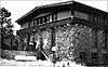
| Grand Canyon Park Operations Building Grand Canyon Park Operations Building Grand Canyon Park Operations Building, was built 1929 on the South Rim of the Grand Canyon in Grand Canyon National Park. It is significant as an example of a National Park Service building designed to blend harmoniously with the natural surroundings, in the National Park Service Rustic style... |
 |
Grand Canyon Village Grand Canyon Village, Arizona Grand Canyon Village is a census-designated place located on the South Rim of the Grand Canyon, in Coconino County, Arizona. Its population was 1,460 at the 2000 Census. Located in Grand Canyon National Park, it is wholly focused on accommodating tourists visiting the canyon... 36.0532260853°N 112.136908007°W |
Coconino Coconino County, Arizona -2010:Whereas according to the 2010 U.S. Census Bureau:*61.7% White*1.2% Black*27.3% Native American*1.4% Asian*0.1% Native Hawaiian or Pacific Islander*3.1% Two or more races*5.2% Other races*13.5% Hispanic or Latino -2000:... |
National Park Service building; built in 1929; designed to blend with the natural surroundings | ||
| Grand Canyon Power House Grand Canyon Power House Grand Canyon Power House is a former electric power plant that served National Park Service and concessioner facilities at the South Rim of the Grand Canyon in Grand Canyon National Park. It is significant for its architecture, which masks the building's industrial function behind a veneer of... |
 |
Grand Canyon Village Grand Canyon Village, Arizona Grand Canyon Village is a census-designated place located on the South Rim of the Grand Canyon, in Coconino County, Arizona. Its population was 1,460 at the 2000 Census. Located in Grand Canyon National Park, it is wholly focused on accommodating tourists visiting the canyon... 36.0538731493°N 112.139970434°W |
Coconino Coconino County, Arizona -2010:Whereas according to the 2010 U.S. Census Bureau:*61.7% White*1.2% Black*27.3% Native American*1.4% Asian*0.1% Native Hawaiian or Pacific Islander*3.1% Two or more races*5.2% Other races*13.5% Hispanic or Latino -2000:... |
Form disguises function. | ||
| Grand Canyon Village Grand Canyon Village Historic District Grand Canyon Village Historic District comprises the historic center of Grand Canyon Village, on the South Rim of the Grand Canyon in Grand Canyon National Park, Arizona. The district includes numerous landmark park structures, many of which are National Historic Landmarks themselves, or are... |
 |
Grand Canyon Village Grand Canyon Village, Arizona Grand Canyon Village is a census-designated place located on the South Rim of the Grand Canyon, in Coconino County, Arizona. Its population was 1,460 at the 2000 Census. Located in Grand Canyon National Park, it is wholly focused on accommodating tourists visiting the canyon... |
Coconino Coconino County, Arizona -2010:Whereas according to the 2010 U.S. Census Bureau:*61.7% White*1.2% Black*27.3% Native American*1.4% Asian*0.1% Native Hawaiian or Pacific Islander*3.1% Two or more races*5.2% Other races*13.5% Hispanic or Latino -2000:... |
Planned town significant for its urban planning and ecological sensitivity | ||
| Hoover Dam Hoover Dam Hoover Dam, once known as Boulder Dam, is a concrete arch-gravity dam in the Black Canyon of the Colorado River, on the border between the US states of Arizona and Nevada. It was constructed between 1931 and 1936 during the Great Depression and was dedicated on September 30, 1935, by President... |
 |
Lake Mead National Recreation Area Lake Mead National Recreation Area Lake Mead National Recreation Area is located in southern Nevada and northwestern Arizona. The centerpieces of the National Recreation Area are its two large reservoirs: Lake Mead and Lake Mohave. These lakes cater to boaters, swimmers, sunbathers, and fishermen while the surrounding desert rewards... |
Mohave, AZ Mohave County, Arizona Mohave County is located in the northwestern corner of the U.S. state of Arizona. As of the 2010 census, its population was 200,186, an increase of 45,154 people since the 2000 census count of 155,032. The county seat is Kingman... and Clark, NV Clark County, Nevada -Demographics:As of the census of 2000, there were 1,375,765 people, 512,253 households, and 339,693 families residing within the MSA. The racial makeup of the MSA was 71.6% White , 9.1% Black, 5.7% Asian, 0.8% American Indian and 12.8% of other or mixed race. 22.0% were Hispanic of any race... |
Historic dam, power plant and water-storage facility | ||
| Hubbell Trading Post National Historic Site Hubbell Trading Post National Historic Site Hubbell Trading Post National Historic Site is a meeting ground of two cultures, the Navajo and settlers who came to the area to settle in what is now northeastern Arizona in the late 19th century. These settlers came from Mexico from the south and eastern United States... |
|
Ganado Ganado, Arizona Ganado is a census-designated place in Apache County, Arizona, United States. The population was 1,505 at the 2000 census.Ganado is part of the Navajo Nation... |
Apache Apache County, Arizona -2010:Whereas according to the 2010 U.S. Census Bureau:*23.3% White*0.2% Black*72.9% Native American*0.3% Asian*0.0% Native Hawaiian or Pacific Islander*2.0% Two or more races*1.3% Other races*5.8% Hispanic or Latino -2000:... |
Meeting ground of two cultures, the Navajo and the settlers | ||
| Jerome Historic District Jerome Historic District Jerome Historic District, in Jerome, Arizona, is a historic district that is significant for its association with copper mining.It was declared a National Historic Landmark in 1966.-References:... |
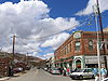 |
Jerome Jerome, Arizona Jerome is a town in Yavapai County, Arizona, United States. According to 2006 Census Bureau estimates, the population of the town is 353.-History:... |
Yavapai Yavapai County, Arizona -2010:Whereas according to the 2010 U.S. Census Bureau:*89.3% White*0.6% Black*1.7% Native American*0.8% Asian*0.1% Native Hawaiian or Pacific Islander*2.5% Two or more races*5.0% Other races*13.6% Hispanic or Latino -2000:... |
Copper mining town | ||
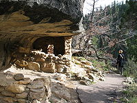
| Kinishba Ruins Kinishba Ruins Kinishba Ruins is a sprawling, 600-room great house archaeological site in eastern Arizona and is administered by the Southern Athabaskan-speaking White Mountain Apache Tribe of the nearby Fort Apache Indian Reservation... |
 |
Whiteriver Whiteriver, Arizona Whiteriver is a census-designated place in Navajo County, Arizona, United States. The population was 5,220 at the 2000 census.-Geography:Whiteriver is located at .... |
Gila Gila County, Arizona -2010:Whereas according to the 2010 U.S. Census Bureau:*76.8% White*0.4% Black*14.8% Native American*0.5% Asian*0.1% Native Hawaiian or Pacific Islander*2.0% Two or more races*5.4% Other races*17.9% Hispanic or Latino -2000:... |
Large pueblo ruin | ||
| Lehner Mammoth-Kill Site Lehner Mammoth-Kill Site The Lehner Mammoth-Kill Site is a site in southern Arizona that is significant for its association with evidence that mammoths were killed here by Paleo-Indians 9000 years BCE.... |
 |
Hereford Hereford, Arizona Hereford is an unincorporated community in Cochise County along the San Pedro Riparian National Conservation Area in the southern part of the U.S. state of Arizona. It is south of Sierra Vista and is a part of the Sierra Vista-Douglas micropolitan area... |
Cochise Cochise County, Arizona -2010:Whereas according to the 2010 U.S. Census Bureau:*78.5% White*4.2% Black*1.2% Native American*1.9% Asian*0.3% Native Hawaiian or Pacific Islander*4.0% Two or more races*9.6% Other races*32.4% Hispanic or Latino -2000:... |
Clovis culture Clovis culture The Clovis culture is a prehistoric Paleo-Indian culture that first appears 11,500 RCYBP , at the end of the last glacial period, characterized by the manufacture of "Clovis points" and distinctive bone and ivory tools... mammoth Mammoth A mammoth is any species of the extinct genus Mammuthus. These proboscideans are members of Elephantidae, the family of elephants and mammoths, and close relatives of modern elephants. They were often equipped with long curved tusks and, in northern species, a covering of long hair... butchering site |
||
| Los Santos Ángeles de Guevavi Mission Los Santos Ángeles de Guevavi Mission Los Santos Ángeles de Guevavi was founded by Jesuit missionary Fathers Kino and Salvatierra in 1691 as La Misión de San Gabriel de Guevavi, a district headquarters in what is now Arizona, near Tumacácori... |
 |
Nogales Nogales, Arizona Nogales is a city in Santa Cruz County, Arizona, United States. The population was 21,017 at the 2010 census. According to 2005 Census Bureau estimates, the population of the city is 20,833. The city is the county seat of Santa Cruz County.... |
Santa Cruz Santa Cruz County, Arizona -2010:Whereas according to the 2010 U.S. Census Bureau:*73.5% White*0.4% Black*0.7% Native American*0.5% Asian*0.0% Native Hawaiian or Pacific Islander*2.0% Two or more races*22.9% Other races*82.8% Hispanic or Latino -2000:... |
Ruins of Spanish mission church; founded 1691 | ||
| Lowell Observatory Lowell Observatory Lowell Observatory is an astronomical observatory in Flagstaff, Arizona. Lowell Observatory was established in 1894, placing it among the oldest observatories in the United States, and was designated a National Historic Landmark in 1965.... |
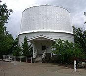 |
Flagstaff Flagstaff, Arizona Flagstaff is a city located in northern Arizona, in the southwestern United States. In 2010, the city's population was 65,870. The population of the Metropolitan Statistical Area was at 134,421 in 2010. It is the county seat of Coconino County... |
Coconino Coconino County, Arizona -2010:Whereas according to the 2010 U.S. Census Bureau:*61.7% White*1.2% Black*27.3% Native American*1.4% Asian*0.1% Native Hawaiian or Pacific Islander*3.1% Two or more races*5.2% Other races*13.5% Hispanic or Latino -2000:... |
Observatory where Pluto was discovered | ||
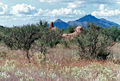
| C. Hart Merriam Base Camp Site C. Hart Merriam Base Camp Site C. Hart Merriam Base Camp Site is significant for its association with Clinton Hart Merriam, the United States' first eco-biologist. The site became a National Historic Landmark in 1965.... |
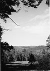 |
Flagstaff Flagstaff, Arizona Flagstaff is a city located in northern Arizona, in the southwestern United States. In 2010, the city's population was 65,870. The population of the Metropolitan Statistical Area was at 134,421 in 2010. It is the county seat of Coconino County... |
Coconino Coconino County, Arizona -2010:Whereas according to the 2010 U.S. Census Bureau:*61.7% White*1.2% Black*27.3% Native American*1.4% Asian*0.1% Native Hawaiian or Pacific Islander*3.1% Two or more races*5.2% Other races*13.5% Hispanic or Latino -2000:... |
Work site of C. Hart Merriam, path-breaking eco-biologist | ||
| Navajo Nation Council Chamber Navajo Nation Council Chamber Navajo Nation Council Chambers is the center of government for the Navajo Nation. The landmark building, in Window Rock, Arizona, is significant for its association with the 1930s New Deal, and its change in Federal policy for relations with Native Americans, as established in the Indian... |
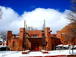 |
Window Rock Window Rock, Arizona Window Rock is the seat of government and capital of the Navajo Nation, the largest territory of a sovereign Native American nation in North America. Window Rock contains the Navajo Nation Council, the Navajo Nation Zoological and Botanical Park, as well as the Navajo Nation World War II Memorial... |
Apache Apache County, Arizona -2010:Whereas according to the 2010 U.S. Census Bureau:*23.3% White*0.2% Black*72.9% Native American*0.3% Asian*0.0% Native Hawaiian or Pacific Islander*2.0% Two or more races*1.3% Other races*5.8% Hispanic or Latino -2000:... |
Center of government for Navajo Nation Navajo Nation The Navajo Nation is a semi-autonomous Native American-governed territory covering , occupying all of northeastern Arizona, the southeastern portion of Utah, and northwestern New Mexico... . |
||
| Old Oraibi | 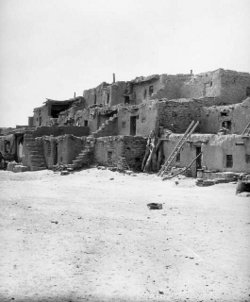 |
Oraibi |
Navajo Navajo County, Arizona -2010:Whereas according to the 2010 U.S. Census Bureau:*49.3% White*0.9% Black*43.4% Native American*0.5% Asian*0.1% Native Hawaiian or Pacific Islander*2.5% Two or more races*3.3% Other races*10.8% Hispanic or Latino -2000:... |
Historic Hopi village | ||
| Painted Desert Inn Painted Desert Inn Painted Desert Inn is a lodge in Petrified Forest National Park in Arizona. It was built in 1937–1940, on the site of an earlier lodge, the Stone Tree House. It was designed in 1937 by National Park Service architect Lyle E. Bennett and others from the Park Service Branch of Plans and Design.... |
 |
Petrified Forest National Park 35.0837366507°N 109.788845035°W |
Apache Apache County, Arizona -2010:Whereas according to the 2010 U.S. Census Bureau:*23.3% White*0.2% Black*72.9% Native American*0.3% Asian*0.0% Native Hawaiian or Pacific Islander*2.0% Two or more races*1.3% Other races*5.8% Hispanic or Latino -2000:... |
Lodge in the Petrified Forest National Park | ||
| Phelps Dodge General Office Building Phelps Dodge General Office Building Phelps Dodge General Office Building is a National Historic Landmark in Bisbee, Arizona. It was declared a National Historic Landmark in 1983.The building was the headquarters of the Phelps Dodge mining company from 1896 to 1961. It is located at Copper Queen Plaza on Main Street at Brewery Gulch.... |
 |
Bisbee Bisbee, Arizona Bisbee is a city in Cochise County, Arizona, United States, 82 miles southeast of Tucson. According to 2005 Census Bureau estimates, the population of the city was 6,177... 31.4401856866°N 109.911260835°W |
Cochise Cochise County, Arizona -2010:Whereas according to the 2010 U.S. Census Bureau:*78.5% White*4.2% Black*1.2% Native American*1.9% Asian*0.3% Native Hawaiian or Pacific Islander*4.0% Two or more races*9.6% Other races*32.4% Hispanic or Latino -2000:... |
Phelps Dodge mining company headquarters from 1896 to 1961 | ||
| Point of Pines Sites Point of Pines Sites Point of Pines Sites is a set of archaeological sites in the U.S. state of Arizona that are significant for associations with Anasazi, Mogollon and Hohokam cultures. The sites were chosen as a field school location by Dr... |
 |
Morenci Morenci, Arizona Morenci is a census-designated place in Greenlee County, Arizona, United States. The population was 1,879 at the 2000 census. It is part of the Safford Micropolitan Statistical Area... |
Graham Graham County, Arizona -2010:Whereas according to the 2010 U.S. Census Bureau:*72.1% White*1.8% Black*14.4% Native American*0.5% Asian*0.1% Native Hawaiian or Pacific Islander*2.8% Two or more races*8.3% Other races*30.4% Hispanic or Latino -2000:... |
Set of archaeological sites associated with Anasazi, Mogollon and Hohokam cultures | ||
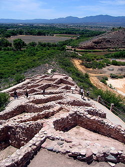
| Pueblo Grande Ruin and Irrigation Sites Pueblo Grande Ruin and Irrigation Sites Pueblo Grande Ruin and Irrigation Sites is a site in Arizona that is significant for its association with Native American history. It is believed that this area was settled around 450 AD... |
 |
Phoenix Phoenix, Arizona Phoenix is the capital, and largest city, of the U.S. state of Arizona, as well as the sixth most populated city in the United States. Phoenix is home to 1,445,632 people according to the official 2010 U.S. Census Bureau data... |
Maricopa Maricopa County, Arizona -2010:Whereas according to the 2010 U.S. Census Bureau:*73.0% White*5.0% Black*2.1% Native American*3.5% Asian*0.2% Native Hawaiian or Pacific Islander*3.5% Two or more races*12.7% Other races*29.6% Hispanic or Latino -2000:... |
Pueblo Grande Ruin and adjacent Hohokam-Pima Irrigation Sites | ||
| Sage Memorial Hospital School of Nursing Sage Memorial Hospital School of Nursing Sage Memorial Hospital School of Nursing in Ganado, Arizona was designated a U.S. National Historic Landmark on January 16, 2008.The press release read:... |
image pending | Ganodo Ganado, Arizona Ganado is a census-designated place in Apache County, Arizona, United States. The population was 1,505 at the 2000 census.Ganado is part of the Navajo Nation... |
Apache Apache County, Arizona -2010:Whereas according to the 2010 U.S. Census Bureau:*23.3% White*0.2% Black*72.9% Native American*0.3% Asian*0.0% Native Hawaiian or Pacific Islander*2.0% Two or more races*1.3% Other races*5.8% Hispanic or Latino -2000:... |
|||
| San Bernardino Ranch San Bernardino Ranch San Bernardino Ranch is a site in the southern San Bernardino Valley in the region of the San Bernardino National Wildlife Refuge in extreme southeast Cochise County, Arizona that is significant for its association with the beginning of cattle ranching in southern Arizona and northern Mexico. The... |
 |
Douglas Douglas, Arizona Douglas is a city in Cochise County, Arizona, United States. Douglas has a border crossing with Mexico and a history of mining.The population was 14,312 at the 2000 census... |
Cochise Cochise County, Arizona -2010:Whereas according to the 2010 U.S. Census Bureau:*78.5% White*4.2% Black*1.2% Native American*1.9% Asian*0.3% Native Hawaiian or Pacific Islander*4.0% Two or more races*9.6% Other races*32.4% Hispanic or Latino -2000:... |
Historic cattle ranch | ||
| San Cayetano de Calabazas Mission San Cayetano de Calabazas Mission San Cayetano de Calabazas, also known as Calabasas, was founded by Jesuit missionary Father Francisco Xavier Pauer in 1756 when he relocated at least seventy-eight Pima Indians to the site from their village of Toacuquita in what is now Arizona, near Tumacácori... |
 |
Nogales Nogales, Arizona Nogales is a city in Santa Cruz County, Arizona, United States. The population was 21,017 at the 2010 census. According to 2005 Census Bureau estimates, the population of the city is 20,833. The city is the county seat of Santa Cruz County.... |
Santa Cruz Santa Cruz County, Arizona -2010:Whereas according to the 2010 U.S. Census Bureau:*73.5% White*0.4% Black*0.7% Native American*0.5% Asian*0.0% Native Hawaiian or Pacific Islander*2.0% Two or more races*22.9% Other races*82.8% Hispanic or Latino -2000:... |
Spanish mission, also known as Calabasas | ||
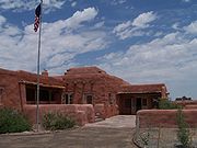
| San Xavier del Bac Mission Mission San Xavier del Bac Mission San Xavier del Bac is a historic Spanish Catholic mission located about 10 miles south of downtown Tucson, Arizona, on the Tohono O'odham San Xavier Indian Reservation... |
 |
Tucson Tucson, Arizona Tucson is a city in and the county seat of Pima County, Arizona, United States. The city is located 118 miles southeast of Phoenix and 60 miles north of the U.S.-Mexico border. The 2010 United States Census puts the city's population at 520,116 with a metropolitan area population at 1,020,200... |
Pima Pima County, Arizona -2010:Whereas according to the 2010 U.S. Census Bureau:*74.3% White*3.5% Black*3.3% Native American*2.6% Asian*0.2% Native Hawaiian or Pacific Islander*3.7% Two or more races*12.4% Other races*34.6% Hispanic or Latino -2000:... |
Spanish mission founded in 1699 | ||
| Sierra Bonita Ranch Sierra Bonita Ranch Sierra Bonita Ranch is a site in Arizona that is significant for its association with Colonel Henry C. Hooker's cattle ranch, the first permanent American cattle ranch in Arizona, located near present-day Willcox, Arizona overlooking the Sulphur Springs Valley... |
 |
Bonita 32.583333°N 109.966667°W |
Cochise Cochise County, Arizona -2010:Whereas according to the 2010 U.S. Census Bureau:*78.5% White*4.2% Black*1.2% Native American*1.9% Asian*0.3% Native Hawaiian or Pacific Islander*4.0% Two or more races*9.6% Other races*32.4% Hispanic or Latino -2000:... and Graham Graham County, Arizona -2010:Whereas according to the 2010 U.S. Census Bureau:*72.1% White*1.8% Black*14.4% Native American*0.5% Asian*0.1% Native Hawaiian or Pacific Islander*2.8% Two or more races*8.3% Other races*30.4% Hispanic or Latino -2000:... |
First permanent American cattle ranch in Arizona | ||
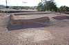
| Snaketown Hohokam Pima National Monument The Hohokam Pima National Monument, which includes the archaeological site known as Snaketown, is an ancient Hohokam village within the Gila River Indian Community, near present day Sacaton, Arizona. Snaketown was designated a National Historic Landmark in 1964... |
 |
Pinal Pinal County, Arizona -2010:Whereas according to the 2010 U.S. Census Bureau:*72.4% White*4.6% Black*5.6% Native American*1.7% Asian*0.4% Native Hawaiian or Pacific Islander*3.8% Two or more races*11.5% Other races*28.5% Hispanic or Latino -2000:... |
Archaeological remains of the Hohokam culture | |||
| Taliesin West Taliesin West Taliesin West was architect Frank Lloyd Wright's winter home and school in the desert from 1937 until his death in 1959 at the age of 91. Today it is the main campus of the Frank Lloyd Wright School of Architecture and houses the Frank Lloyd Wright Foundation.Open to the public for tours, Taliesin... |
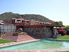 |
Scottsdale Scottsdale, Arizona Scottsdale is a city in the eastern part of Maricopa County, Arizona, United States, adjacent to Phoenix. According to the U.S. Census Bureau, as of 2010 the population of the city was 217,385... 33.603111°N 111.843781°W |
Maricopa Maricopa County, Arizona -2010:Whereas according to the 2010 U.S. Census Bureau:*73.0% White*5.0% Black*2.1% Native American*3.5% Asian*0.2% Native Hawaiian or Pacific Islander*3.5% Two or more races*12.7% Other races*29.6% Hispanic or Latino -2000:... |
Winter home of architect Frank Lloyd Wright Frank Lloyd Wright Frank Lloyd Wright was an American architect, interior designer, writer and educator, who designed more than 1,000 structures and completed 500 works. Wright believed in designing structures which were in harmony with humanity and its environment, a philosophy he called organic architecture... |
||
| Tombstone Historic District Tombstone Historic District Tombstone Historic District is a historic district in Tombstone, Arizona that is significant for its association with the struggle between lawlessness and civility in frontier towns of the wild west. Located within the historical district is the legendary O.K. Corral associated with the famous... |
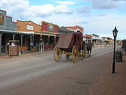 |
Tombstone Tombstone, Arizona Tombstone is a city in Cochise County, Arizona, United States, founded in 1879 by Ed Schieffelin in what was then Pima County, Arizona Territory. It was one of the last wide-open frontier boomtowns in the American Old West. From about 1877 to 1890, the town's mines produced USD $40 to $85 million... |
Cochise Cochise County, Arizona -2010:Whereas according to the 2010 U.S. Census Bureau:*78.5% White*4.2% Black*1.2% Native American*1.9% Asian*0.3% Native Hawaiian or Pacific Islander*4.0% Two or more races*9.6% Other races*32.4% Hispanic or Latino -2000:... |
Classic Western mining boomtown; location of the OK Corral | ||
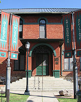
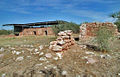
| Tumacacori Museum | 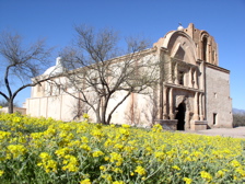 |
Tumacacori 31.5660648509°N 111.050401755°W |
Santa Cruz Santa Cruz County, Arizona -2010:Whereas according to the 2010 U.S. Census Bureau:*73.5% White*0.4% Black*0.7% Native American*0.5% Asian*0.0% Native Hawaiian or Pacific Islander*2.0% Two or more races*22.9% Other races*82.8% Hispanic or Latino -2000:... |
Museum to Spanish missions that itself is an architectural landmark | ||
| Ventana Cave Ventana Cave Ventana Cave is an archaeological site in southern Arizona. It is located on the Tohono O'odham Indian Reservation. The cave was excavated by Emil Haury and Julian Hayden in 1941-42. The deepest artifacts from Ventana Cave were recovered from a layer of volcanic debris that also contained... |
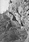 |
Santa Rosa |
Pima Pima County, Arizona -2010:Whereas according to the 2010 U.S. Census Bureau:*74.3% White*3.5% Black*3.3% Native American*2.6% Asian*0.2% Native Hawaiian or Pacific Islander*3.7% Two or more races*12.4% Other races*34.6% Hispanic or Latino -2000:... |
Archaeological site; has evidence of Native American occupation of the area for the last 4,000 years | ||
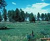
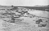
| Winona Site Winona Site Winona Site is an archaeological site. It is located near Sunset Crater, which erupted in 1066. Cultural changes following this eruption are evidenced by findings at this site.It was declared a National Historic Landmark in 1964.... |
image pending | Winona Winona, Arizona Winona is a small unincorporated community in Coconino County in the northern part of the U.S. state of Arizona.It is located along U.S. Route 66 and was made famous in the song " Route 66"... |
Coconino Coconino County, Arizona -2010:Whereas according to the 2010 U.S. Census Bureau:*61.7% White*1.2% Black*27.3% Native American*1.4% Asian*0.1% Native Hawaiian or Pacific Islander*3.1% Two or more races*5.2% Other races*13.5% Hispanic or Latino -2000:... |
Archaeological site; evidence of cultural change following eruption of Sunset Crater | ||
| Yuma Crossing and Associated Sites Yuma Crossing and Associated Sites Yuma Crossing is a site in Arizona and California that is significant for its association with transportation and communication across the Colorado River. It connected New Spain and Las Californias in the Spanish Colonial period in and also during the Western expansion of the United States. ... |
 |
Yuma, AZ Yuma, Arizona Yuma is a city in and the county seat of Yuma County, Arizona, United States. It is located in the southwestern corner of the state, and the population of the city was 77,515 at the 2000 census, with a 2008 Census Bureau estimated population of 90,041.... and Winterhaven, CA Winterhaven, California Winterhaven is a census-designated place in Imperial County, California. Winterhaven is located east of Pilot Knob, The population was 394 at the 2010 census, down from 529 at the 2000 census. It is part of the 'El Centro, California Metropolitan Statistical Area'... |
Yuma County, AZ Yuma County, Arizona -2010:Whereas according to the 2010 U.S. Census Bureau:*70.4% White*2.0% Black*1.6% Native American*1.2% Asian*0.2% Native Hawaiian or Pacific Islander*3.8% Two or more races*20.8% Other races*59.7% Hispanic or Latino -2000:... and Imperial County, CA Imperial County, California Imperial County is a county located in the Imperial Valley, in the far southeast of the U.S. state of California, bordering both Arizona and Mexico. It is part of the El Centro Metropolitan Area, which encompasses all of Imperial County. The population as of 2000 was 142,361. The county seat is the... |
Archaeological and historical sites including Yuma Quartermaster Depot and Arizona Territorial Prison |
Historic areas of the NPS in Arizona
National Historic Sites, National Historical Parks, some National Monuments, and certain other areas listed in the National Park system are historic landmarks of national importance that are highly protected already, often before the inauguration of the NHL program in 1960, and are then often not also named NHLs per se. There are fourteen of these in Arizona. The National Park Service lists these fourteen together with the NHLs in the state,Hohokam Pima National Monument
Hohokam Pima National Monument
The Hohokam Pima National Monument, which includes the archaeological site known as Snaketown, is an ancient Hohokam village within the Gila River Indian Community, near present day Sacaton, Arizona. Snaketown was designated a National Historic Landmark in 1964...
, Fort Bowie National Historic Site, and Hubbell Trading Post National Historic Site
Hubbell Trading Post National Historic Site
Hubbell Trading Post National Historic Site is a meeting ground of two cultures, the Navajo and settlers who came to the area to settle in what is now northeastern Arizona in the late 19th century. These settlers came from Mexico from the south and eastern United States...
are also NHLs and are listed above. The other 11 are:
| Landmark name |
Image | Date established | Location | County | Description | |
|---|---|---|---|---|---|---|
| Canyon de Chelly National Monument Canyon de Chelly National Monument Canyon de Chelly National Monument was established on April 1, 1931 as a unit of the National Park Service. It is located in northeastern Arizona within the boundaries of the Navajo Nation... |
 |
Chinle Chinle, Arizona Chinle is a census-designated place in Apache County, Arizona, United States. The population was 5,366 at the 2000 census.-Geography:Chinle is located at .... |
Apache Apache County, Arizona -2010:Whereas according to the 2010 U.S. Census Bureau:*23.3% White*0.2% Black*72.9% Native American*0.3% Asian*0.0% Native Hawaiian or Pacific Islander*2.0% Two or more races*1.3% Other races*5.8% Hispanic or Latino -2000:... |
Navajo Tribal Trust Land preserving artifacts of indigenous peoples. | ||
| Casa Grande Ruins National Monument Casa Grande Ruins National Monument Casa Grande Ruins National Monument, in Coolidge, Arizona, just northeast of the city of Casa Grande, preserves a group of Ancient Pueblo Peoples Hohokam structures of the Pueblo III and Pueblo IV Eras.-Ancient pueblos:... |
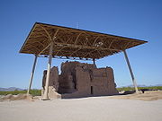 |
Coolidge Coolidge, Arizona Coolidge is a city in Pinal County, Arizona, United States. According to 2005 Census Bureau estimates, the population of the city is 8,154.Arizona Highway 87 and Arizona Highway 287 pass through the town. Coolidge is 56 miles southeast of Phoenix, and 69 miles northwest of Tucson. It is 21 miles... |
Pinal Pinal County, Arizona -2010:Whereas according to the 2010 U.S. Census Bureau:*72.4% White*4.6% Black*5.6% Native American*1.7% Asian*0.4% Native Hawaiian or Pacific Islander*3.8% Two or more races*11.5% Other races*28.5% Hispanic or Latino -2000:... |
Ruins of Hohokam structures. A four story structure is the "casa grande" or "big house". Sheltered since 1932 under a large pavilion built to preserve the ruins. | ||
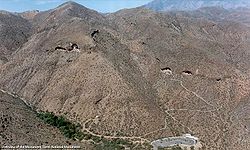
| Coronado National Memorial Coronado National Memorial The Coronado National Memorial commemorates the first organized expedition into the Southwest by conquistador Francisco Vásquez de Coronado. The memorial is located in a natural setting on the international border on the southeast flank of the Huachuca Mountains south of Sierra Vista, Arizona... |
 |
Sierra Vista Sierra Vista, Arizona Sierra Vista is a city in Cochise County, Arizona, United States. According to 2007 Census Bureau estimates, the population of the city is 43,044.... |
Cochise Cochise County, Arizona -2010:Whereas according to the 2010 U.S. Census Bureau:*78.5% White*4.2% Black*1.2% Native American*1.9% Asian*0.3% Native Hawaiian or Pacific Islander*4.0% Two or more races*9.6% Other races*32.4% Hispanic or Latino -2000:... |
Commemorates the first organized expedition into the Southwest by conquistador Francisco Vásquez de Coronado. | ||
| Montezuma Castle National Monument Montezuma Castle National Monument Montezuma Castle National Monument, located near Camp Verde, Arizona, in the Southwestern United States, features well-preserved cliff-dwellings. They were built and used by the Pre-Columbian Sinagua people, northern cousins of the Hohokam, around 700 AD. Several Hopi clans trace their roots to... |
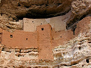 |
Camp Verde Camp Verde, Arizona Camp Verde is a town in Yavapai County, Arizona, United States. According to 2006 Census Bureau estimates, the population of the town is 10,610.... |
Yavapai Yavapai County, Arizona -2010:Whereas according to the 2010 U.S. Census Bureau:*89.3% White*0.6% Black*1.7% Native American*0.8% Asian*0.1% Native Hawaiian or Pacific Islander*2.5% Two or more races*5.0% Other races*13.6% Hispanic or Latino -2000:... |
Well-preserved cliff dwellings built and used by the Pre-Columbian Sinagua people around 1400 AD. | ||
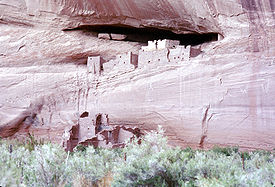
| Navajo National Monument Navajo National Monument Navajo National Monument is located within the northwest portion of the Navajo Reservation in northern Arizona.Navajo National Monument preserves three of the most intact cliff dwellings of the ancestral puebloan people . The Navajo people who live here today call these ancient ones Anasazi... |
 |
Window Rock Window Rock, Arizona Window Rock is the seat of government and capital of the Navajo Nation, the largest territory of a sovereign Native American nation in North America. Window Rock contains the Navajo Nation Council, the Navajo Nation Zoological and Botanical Park, as well as the Navajo Nation World War II Memorial... |
Navajo Navajo County, Arizona -2010:Whereas according to the 2010 U.S. Census Bureau:*49.3% White*0.9% Black*43.4% Native American*0.5% Asian*0.1% Native Hawaiian or Pacific Islander*2.5% Two or more races*3.3% Other races*10.8% Hispanic or Latino -2000:... |
Preserves three of the most intact cliff dwellings of the ancestral puebloan people (Hisatsinom). | ||
| Pipe Spring National Monument Pipe Spring National Monument Pipe Spring National Monument is located in the U.S. state of Arizona, and is rich with American Indian, early explorer, and Mormon pioneer history... |
Fredonia, Arizona Fredonia, Arizona Fredonia is a town in Coconino County, Arizona, United States. Fredonia is Arizona's northernmost town and the gateway to the North Rim of the Grand Canyon. Visitors enjoy seeing the Grand Canyon from the North Rim because they can experience the wonder and beauty without large crowds and high... 36.8625°N 112.729444°W |
Mohave Mohave County, Arizona Mohave County is located in the northwestern corner of the U.S. state of Arizona. As of the 2010 census, its population was 200,186, an increase of 45,154 people since the 2000 census count of 155,032. The county seat is Kingman... |
Discovered and named in 1856 by Latter-day Saint missionaries. Mormon cattle ranching operation established in 1860's. Protective fort was built in 1872. Way station for travellers. Refuge for polygamist wives. | |||
| Tonto National Monument Tonto National Monument Tonto National Monument is a National Monument in central Arizona, United States. The area lies on the northeastern edge of the Sonoran Desert, which is generally arid land with annual rainfall of about 16 inches here... |
 |
Roosevelt Roosevelt, Arizona Roosevelt is an unincorporated community in Gila County in the U.S. State of Arizona, located on the south shore of Theodore Roosevelt Lake. Roosevelt has a ZIP Code of 85545; in 2000, the population of the 85545 ZCTA was 616.... |
Gila Gila County, Arizona -2010:Whereas according to the 2010 U.S. Census Bureau:*76.8% White*0.4% Black*14.8% Native American*0.5% Asian*0.1% Native Hawaiian or Pacific Islander*2.0% Two or more races*5.4% Other races*17.9% Hispanic or Latino -2000:... |
Well-preserved cliff dwellings were occupied by the Salado culture during the 13th, 14th, and early 15th centuries. | ||
| Tumacacori National Historical Park Tumacácori National Historical Park Tumacácori National Historical Park is located in the upper Santa Cruz River Valley of southern Arizona. The park protects the ruins of three Spanish mission communities, two of which are National Historic Landmark sites, and it also contains the Tumacácori Museum, a historic landmark building... |
|
Nogales Nogales, Arizona Nogales is a city in Santa Cruz County, Arizona, United States. The population was 21,017 at the 2010 census. According to 2005 Census Bureau estimates, the population of the city is 20,833. The city is the county seat of Santa Cruz County.... |
Santa Cruz Santa Cruz County, Arizona -2010:Whereas according to the 2010 U.S. Census Bureau:*73.5% White*0.4% Black*0.7% Native American*0.5% Asian*0.0% Native Hawaiian or Pacific Islander*2.0% Two or more races*22.9% Other races*82.8% Hispanic or Latino -2000:... |
Includes 2 missions and a museum that are NHLs listed above, plus a mission that is not an NHL. | ||
| Tuzigoot National Monument Tuzigoot National Monument Tuzigoot National Monument preserves a 2 to 3 story pueblo ruin on the summit of a limestone and sandstone ridge just east of Clarkdale, Arizona, 120 feet above the Verde River floodplain. The pueblo has 110 rooms... |
 |
Clarkdale Clarkdale, Arizona Clarkdale is a town in Yavapai County, Arizona, United States. According to 2006 Census Bureau estimates, the population of the town is 3,836.Clarkdale, formerly a mining town, is now largely a retirement community with an eye for the arts.-History:... |
Yavapai Yavapai County, Arizona -2010:Whereas according to the 2010 U.S. Census Bureau:*89.3% White*0.6% Black*1.7% Native American*0.8% Asian*0.1% Native Hawaiian or Pacific Islander*2.5% Two or more races*5.0% Other races*13.6% Hispanic or Latino -2000:... |
Preserves a 2 to 3 story pueblo ruin | ||
| Walnut Canyon National Monument Walnut Canyon National Monument Walnut Canyon National Monument is a United States National Monument located about southeast of downtown Flagstaff, Arizona, just off Interstate 40. The canyon rim lies at ; the canyon's floor is 350 ft lower... |
 |
Flagstaff Flagstaff, Arizona Flagstaff is a city located in northern Arizona, in the southwestern United States. In 2010, the city's population was 65,870. The population of the Metropolitan Statistical Area was at 134,421 in 2010. It is the county seat of Coconino County... |
Coconino Coconino County, Arizona -2010:Whereas according to the 2010 U.S. Census Bureau:*61.7% White*1.2% Black*27.3% Native American*1.4% Asian*0.1% Native Hawaiian or Pacific Islander*3.1% Two or more races*5.2% Other races*13.5% Hispanic or Latino -2000:... |
Includes twenty-five cliff dwelling rooms constructed by the Sinagua people | ||
| Wupatki National Monument Wupatki National Monument The Wupatki National Monument is a National Monument located in north-central Arizona, near Flagstaff. Rich in Native American ruins, the monument is administered by the National Park Service in close conjunction with the nearby Sunset Crater Volcano National Monument.Wupatki was listed on the... |
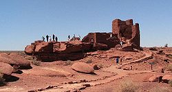 |
Flagstaff Flagstaff, Arizona Flagstaff is a city located in northern Arizona, in the southwestern United States. In 2010, the city's population was 65,870. The population of the Metropolitan Statistical Area was at 134,421 in 2010. It is the county seat of Coconino County... |
Coconino Coconino County, Arizona -2010:Whereas according to the 2010 U.S. Census Bureau:*61.7% White*1.2% Black*27.3% Native American*1.4% Asian*0.1% Native Hawaiian or Pacific Islander*3.1% Two or more races*5.2% Other races*13.5% Hispanic or Latino -2000:... |
Settlement sites built by the Ancient Pueblo Peoples; Sinagua, Cohonina, and Kayenta Anasazi | ||
See also
- National Register of Historic Places listings in Arizona
- List of National Historic Landmarks by state