

Springerville, Arizona
Encyclopedia
Springerville is a town in Apache County, Arizona
, United States within the White Mountains
. Its postal ZIP code
is 85938. According to 2006 Census Bureau estimates, the population of the town is 1,956.
Springerville sits at an elevation of 6,974 feet. Along with its neighbor Eagar
, both communities make up the place known as Round Valley which is in the northeastern part of Arizona close to the New Mexico
border.
, Milligan Settlement, and Valle Redondo (Round Valley).
Outlaw Cowboy
Ike Clanton
, who was present at the Gunfight at the O.K. Corral
, was shot dead in Springerville by detective Jonas V. Brighton when he resisted arrest on charges of cattle-rustling
on June 1, 1887.
The town was incorporated in 1948.
In June 2011, the entire town was evacuated due to a nearby wildfire
.
According to the United States Census Bureau
, the town has a total area of 11.7 square miles (30.3 km²), of which, 11.6 square miles (30 km²) of it is land and 0.1 square mile (0.258998811 km²) of it (1.20%) is water.
, 0.20% Black
or African American
, 6.54% Native American
, 0.41% Asian
, 0.10% Pacific Islander
, 10.24% from other races
, and 3.04% from two or more races. 25.20% of the population were Hispanic
or Latino
of any race.
There were 753 households out of which 34.3% had children under the age of 18 living with them, 50.6% were married couples living together, 11.2% had a female householder with no husband present, and 33.7% were non-families. 30.1% of all households were made up of individuals and 14.7% had someone living alone who was 65 years of age or older. The average household size was 2.55 and the average family size was 3.18.
In the town the age distribution of the population shows 29.2% under the age of 18, 7.6% from 18 to 24, 25.2% from 25 to 44, 23.4% from 45 to 64, and 14.6% who were 65 years of age or older. The median age was 37 years. For every 100 females there were 94.9 males. For every 100 females age 18 and over, there were 88.4 males.
The median income for a household in the town was $30,769, and the median income for a family was $36,331. Males had a median income of $32,313 versus $19,519 for females. The per capita income
for the town was $13,830. About 14.7% of families and 21.0% of the population were below the poverty line, including 25.4% of those under age 18 and 26.1% of those age 65 or over.
. The school's mascot is the elk
and its school colors are black and gold. The St. Johns Redskins are the school's biggest rival.
Round Valley Primary School is located in the town and serves the town.
Round Valley Intermediate School, Round Valley Middle School, and Round Valley High School
serve the town are in nearby Eagar
. In addition, White Mountain Academy, a K-12 charter school, is located in Eagar.
The high school's football stadium, The Round Valley Ensphere located in Eagar, is the eighth biggest geodesic dome
in the world with a diameter of 440 feet / 134 m. The school board voted to give the Dome a pinkish looking color, and it was completed in 1992. It was used as a shelter for evacuees from the Rodeo-Chediski fire
in 2002. Round Valley is the only high school in the world to have a domed stadium.
The first Springerville School House was dedicated September 3, 1884.
In 1969—the Springerville, Eagar, Vernon
, Nutrioso
, Greer
, and Colter Schools consolidated with each other to form the Round Valley Unified School District.
is a town-owned public-use airport located one nautical mile
(1.85 km) west of the central business district
of Springerville.
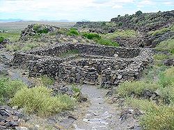 Casa Malpais
is located near Springerville. It is a nationally recognized archeological site.
The name Casa Malpais means House of the Badlands, which was given to the site by early Basque
sheepherders who referred to the surrounding volcanic lava field as "badlands." The Springerville volcanic field
contains over 400 volcanoes within a fifty mile radius of Springerville, making it the third largest volcanic field in the continental United States.
The first visit to Casa Malpais by a professional anthropologist was in 1883, when Frank Cushing, an anthropologist living at Zuni, visited a site at "El Valle Redondo on the Colorado Chiquito", and was impressed by what he termed "the fissure type pueblo
" he found there. In his journal he sketched dry masonry, bridging fissures, upon which the pueblo is constructed.
Unique and unusual features characterize the site. The Great Kiva
, painstakingly constructed of volcanic rock, is the centerpiece. A steep basalt
staircase set into a crevice of the high red cliff wall leads to the top of the mesa.
Both the Hopi
and Zuni Indian tribes still consider Casa Malpais a sacred ancestral place.
The town contains one of the twelve Madonna of the Trail
monuments created by sculptor
The town is close to the Apache-Sitgreaves National Forest
, which runs along the Mogollon Rim
. It is also close to the Sunrise Ski Resort
.
Apache County, Arizona
-2010:Whereas according to the 2010 U.S. Census Bureau:*23.3% White*0.2% Black*72.9% Native American*0.3% Asian*0.0% Native Hawaiian or Pacific Islander*2.0% Two or more races*1.3% Other races*5.8% Hispanic or Latino -2000:...
, United States within the White Mountains
White Mountains (Arizona)
The White Mountains of Arizona are a mountain range and mountainous region in the eastern part of the state, near the border with New Mexico; it is a continuation from the west of the Arizona transition zone–Mogollon Rim, with the Rim ending in western New Mexico...
. Its postal ZIP code
ZIP Code
ZIP codes are a system of postal codes used by the United States Postal Service since 1963. The term ZIP, an acronym for Zone Improvement Plan, is properly written in capital letters and was chosen to suggest that the mail travels more efficiently, and therefore more quickly, when senders use the...
is 85938. According to 2006 Census Bureau estimates, the population of the town is 1,956.
Springerville sits at an elevation of 6,974 feet. Along with its neighbor Eagar
Eagar, Arizona
Eagar is a town in Apache County, Arizona, United States. According to 2006 Census Bureau estimates, the population of the town is 4,126.Eagar was first settled in 1871.-Geography:Eagar is located at ....
, both communities make up the place known as Round Valley which is in the northeastern part of Arizona close to the New Mexico
New Mexico
New Mexico is a state located in the southwest and western regions of the United States. New Mexico is also usually considered one of the Mountain States. With a population density of 16 per square mile, New Mexico is the sixth-most sparsely inhabited U.S...
border.
History
The town that grew around Henry Springer's trading post was officially given its name on May 10, 1876. Before that time it had gone by names such as Colorado ChiquitoLittle Colorado River
The Little Colorado River is a river in the U.S. state of Arizona, providing the principal drainage from the Painted Desert region. Together with its major tributary, the Puerco River, it drains an area of about in eastern Arizona and western New Mexico...
, Milligan Settlement, and Valle Redondo (Round Valley).
Outlaw Cowboy
The Cowboys (Cochise County)
The Cowboys were a loosely associated group of outlaw cowboys in Pima and Cochise County, Arizona Territory in the late 19th century. They were cattle rustlers and robbers who rode across the border into Mexico and rounded up cattle that they then sold in the United States...
Ike Clanton
Ike Clanton
Joseph Isaac Clanton was born in Callaway County, Missouri. He is best known for being a member of group of outlaw Cowboys that had ongoing conflicts with lawmen Wyatt, Virgil, Morgan Earp and Wyatt's friend Doc Holliday. The Clantons repeatedly threatened the Earps because they interfered with...
, who was present at the Gunfight at the O.K. Corral
Gunfight at the O.K. Corral
The Gunfight at the O.K. Corral was a roughly 30-second gunfight that took place at about 3:00 p.m. on Wednesday, October 26, 1881, in Tombstone, Cochise County, Arizona Territory, of the United States. Outlaw Cowboys Ike Clanton and Billy Claiborne ran from the fight, unharmed, but Ike's brother...
, was shot dead in Springerville by detective Jonas V. Brighton when he resisted arrest on charges of cattle-rustling
Cattle raiding
Cattle raiding is the act of stealing cattle.In Australia, such stealing is often referred to as duffing, and the person as a duffer...
on June 1, 1887.
The town was incorporated in 1948.
In June 2011, the entire town was evacuated due to a nearby wildfire
Wallow Fire
-External links:* - InciWeb Incident Information System* at University of Maryland* by the U.S. Forest Service at Flickr.com*...
.
Geography
Springerville is located at 34°8′11"N 109°16′45"W (34.136342, -109.279227).According to the United States Census Bureau
United States Census Bureau
The United States Census Bureau is the government agency that is responsible for the United States Census. It also gathers other national demographic and economic data...
, the town has a total area of 11.7 square miles (30.3 km²), of which, 11.6 square miles (30 km²) of it is land and 0.1 square mile (0.258998811 km²) of it (1.20%) is water.
Demographics
As of the census of 2000, there were 1,972 people, 753 households, and 499 families residing in the town. The population density was 170.8 people per square mile (65.9/km²). There were 896 housing units at an average density of 77.6 per square mile (30.0/km²). The racial makeup of the town was 79.46% WhiteRace (United States Census)
Race and ethnicity in the United States Census, as defined by the Federal Office of Management and Budget and the United States Census Bureau, are self-identification data items in which residents choose the race or races with which they most closely identify, and indicate whether or not they are...
, 0.20% Black
Race (United States Census)
Race and ethnicity in the United States Census, as defined by the Federal Office of Management and Budget and the United States Census Bureau, are self-identification data items in which residents choose the race or races with which they most closely identify, and indicate whether or not they are...
or African American
Race (United States Census)
Race and ethnicity in the United States Census, as defined by the Federal Office of Management and Budget and the United States Census Bureau, are self-identification data items in which residents choose the race or races with which they most closely identify, and indicate whether or not they are...
, 6.54% Native American
Race (United States Census)
Race and ethnicity in the United States Census, as defined by the Federal Office of Management and Budget and the United States Census Bureau, are self-identification data items in which residents choose the race or races with which they most closely identify, and indicate whether or not they are...
, 0.41% Asian
Race (United States Census)
Race and ethnicity in the United States Census, as defined by the Federal Office of Management and Budget and the United States Census Bureau, are self-identification data items in which residents choose the race or races with which they most closely identify, and indicate whether or not they are...
, 0.10% Pacific Islander
Race (United States Census)
Race and ethnicity in the United States Census, as defined by the Federal Office of Management and Budget and the United States Census Bureau, are self-identification data items in which residents choose the race or races with which they most closely identify, and indicate whether or not they are...
, 10.24% from other races
Race (United States Census)
Race and ethnicity in the United States Census, as defined by the Federal Office of Management and Budget and the United States Census Bureau, are self-identification data items in which residents choose the race or races with which they most closely identify, and indicate whether or not they are...
, and 3.04% from two or more races. 25.20% of the population were Hispanic
Race (United States Census)
Race and ethnicity in the United States Census, as defined by the Federal Office of Management and Budget and the United States Census Bureau, are self-identification data items in which residents choose the race or races with which they most closely identify, and indicate whether or not they are...
or Latino
Race (United States Census)
Race and ethnicity in the United States Census, as defined by the Federal Office of Management and Budget and the United States Census Bureau, are self-identification data items in which residents choose the race or races with which they most closely identify, and indicate whether or not they are...
of any race.
There were 753 households out of which 34.3% had children under the age of 18 living with them, 50.6% were married couples living together, 11.2% had a female householder with no husband present, and 33.7% were non-families. 30.1% of all households were made up of individuals and 14.7% had someone living alone who was 65 years of age or older. The average household size was 2.55 and the average family size was 3.18.
In the town the age distribution of the population shows 29.2% under the age of 18, 7.6% from 18 to 24, 25.2% from 25 to 44, 23.4% from 45 to 64, and 14.6% who were 65 years of age or older. The median age was 37 years. For every 100 females there were 94.9 males. For every 100 females age 18 and over, there were 88.4 males.
The median income for a household in the town was $30,769, and the median income for a family was $36,331. Males had a median income of $32,313 versus $19,519 for females. The per capita income
Per capita income
Per capita income or income per person is a measure of mean income within an economic aggregate, such as a country or city. It is calculated by taking a measure of all sources of income in the aggregate and dividing it by the total population...
for the town was $13,830. About 14.7% of families and 21.0% of the population were below the poverty line, including 25.4% of those under age 18 and 26.1% of those age 65 or over.
Education
The town is served by the Round Valley Unified School DistrictRound Valley Unified School District
The Round Valley Unified School District is an Arizona school district comprising five schools in Apache County, Arizona. The towns that house the schools of RVUSD include Eagar and Springerville, Arizona. As of 2006, RVUSD has 1610 students...
. The school's mascot is the elk
Elk
The Elk is the large deer, also called Cervus canadensis or wapiti, of North America and eastern Asia.Elk may also refer to:Other antlered mammals:...
and its school colors are black and gold. The St. Johns Redskins are the school's biggest rival.
Round Valley Primary School is located in the town and serves the town.
Round Valley Intermediate School, Round Valley Middle School, and Round Valley High School
Round Valley High School
Round Valley High School is a high school serving 445 students in Eagar, Arizona. It is the only high school in the Round Valley Unified School District.-History:...
serve the town are in nearby Eagar
Eagar, Arizona
Eagar is a town in Apache County, Arizona, United States. According to 2006 Census Bureau estimates, the population of the town is 4,126.Eagar was first settled in 1871.-Geography:Eagar is located at ....
. In addition, White Mountain Academy, a K-12 charter school, is located in Eagar.
The high school's football stadium, The Round Valley Ensphere located in Eagar, is the eighth biggest geodesic dome
Geodesic dome
A geodesic dome is a spherical or partial-spherical shell structure or lattice shell based on a network of great circles on the surface of a sphere. The geodesics intersect to form triangular elements that have local triangular rigidity and also distribute the stress across the structure. When...
in the world with a diameter of 440 feet / 134 m. The school board voted to give the Dome a pinkish looking color, and it was completed in 1992. It was used as a shelter for evacuees from the Rodeo-Chediski fire
Rodeo-Chediski fire
The Rodeo–Chediski Fire was a wildfire that burned in east-central Arizona beginning on June 18, 2002, and was not controlled until July 7. It was the worst forest fire in Arizona's recorded history until June 14th, 2011 when the Wallow Fire surpassed Rodeo-Chediski as the largest fire in Arizona...
in 2002. Round Valley is the only high school in the world to have a domed stadium.
The first Springerville School House was dedicated September 3, 1884.
In 1969—the Springerville, Eagar, Vernon
Vernon, Arizona
Vernon is an unincorporated community in Apache County, Arizona, United States. Vernon is east of Show Low. Vernon has a post office with ZIP code 85940....
, Nutrioso
Nutrioso, Arizona
Nutrioso is an unincorporated community in Apache County, Arizona, United States. Nutrioso is located on U.S. Route 180 and U.S. Route 191 south-southeast of Eagar. Nutrioso has a post office with ZIP code 85932....
, Greer
Greer, Arizona
Greer is an unincorporated community in Apache County, Arizona, United States. It lies at an elevation of approximately 8,500 feet in the White Mountains of Arizona, and is surrounded by the Apache-Sitgreaves National Forest. Greer was founded around 1879 by Mormon settlers from Utah...
, and Colter Schools consolidated with each other to form the Round Valley Unified School District.
Transportation
The Springerville Municipal AirportSpringerville Municipal Airport
Springerville Municipal Airport is a town-owned public-use airport located one nautical mile west of the central business district of Springerville, a town in Apache County, Arizona, United States...
is a town-owned public-use airport located one nautical mile
Nautical mile
The nautical mile is a unit of length that is about one minute of arc of latitude along any meridian, but is approximately one minute of arc of longitude only at the equator...
(1.85 km) west of the central business district
Central business district
A central business district is the commercial and often geographic heart of a city. In North America this part of a city is commonly referred to as "downtown" or "city center"...
of Springerville.
Attractions
Casa Malpais
Casa Malpaís is an ancient pueblo people archaeological site located near the town of Springerville, Arizona. The site is a nationally recognized archaeological site and was declared a National Historic Landmark in 1964.-Description:...
is located near Springerville. It is a nationally recognized archeological site.
The name Casa Malpais means House of the Badlands, which was given to the site by early Basque
Basque people
The Basques as an ethnic group, primarily inhabit an area traditionally known as the Basque Country , a region that is located around the western end of the Pyrenees on the coast of the Bay of Biscay and straddles parts of north-central Spain and south-western France.The Basques are known in the...
sheepherders who referred to the surrounding volcanic lava field as "badlands." The Springerville volcanic field
Springerville volcanic field
Springerville volcanic field is a monogenetic volcanic field located in east-central Arizona, USA. The field consists of 405 discrete vents covering approximately and is the third largest such field in the continental United States, only the San Francisco volcanic field and Medicine Lake volcanic...
contains over 400 volcanoes within a fifty mile radius of Springerville, making it the third largest volcanic field in the continental United States.
The first visit to Casa Malpais by a professional anthropologist was in 1883, when Frank Cushing, an anthropologist living at Zuni, visited a site at "El Valle Redondo on the Colorado Chiquito", and was impressed by what he termed "the fissure type pueblo
Pueblo
Pueblo is a term used to describe modern communities of Native Americans in the Southwestern United States of America. The first Spanish explorers of the Southwest used this term to describe the communities housed in apartment-like structures built of stone, adobe mud, and other local material...
" he found there. In his journal he sketched dry masonry, bridging fissures, upon which the pueblo is constructed.
Unique and unusual features characterize the site. The Great Kiva
Kiva
A kiva is a room used by modern Puebloans for religious rituals, many of them associated with the kachina belief system. Among the modern Hopi and most other Pueblo peoples, kivas are square-walled and underground, and are used for spiritual ceremonies....
, painstakingly constructed of volcanic rock, is the centerpiece. A steep basalt
Basalt
Basalt is a common extrusive volcanic rock. It is usually grey to black and fine-grained due to rapid cooling of lava at the surface of a planet. It may be porphyritic containing larger crystals in a fine matrix, or vesicular, or frothy scoria. Unweathered basalt is black or grey...
staircase set into a crevice of the high red cliff wall leads to the top of the mesa.
Both the Hopi
Hopi
The Hopi are a federally recognized tribe of indigenous Native American people, who primarily live on the Hopi Reservation in northeastern Arizona. The Hopi area according to the 2000 census has a population of 6,946 people. Their Hopi language is one of the 30 of the Uto-Aztecan language...
and Zuni Indian tribes still consider Casa Malpais a sacred ancestral place.
The town contains one of the twelve Madonna of the Trail
Madonna of the Trail
Madonna of the Trail is a series of 12 monuments dedicated to the spirit of pioneer women in the United States. The monuments were commissioned by the National Society of Daughters of the American Revolution...
monuments created by sculptor
The town is close to the Apache-Sitgreaves National Forest
Apache-Sitgreaves National Forest
The Apache-Sitgreaves National Forest is a United States National Forest which runs along the Mogollon Rim and the White Mountains in east-central Arizona and extending into New Mexico, USA. Both forests are managed as one unit by USDA Forest Service from the forest headquarters in Springerville,...
, which runs along the Mogollon Rim
Mogollon Rim
The Mogollon Rim is a topographical and geological feature running across the U.S. state of Arizona. It extends approximately from northern Yavapai County eastward to near the border with New Mexico.-Description:...
. It is also close to the Sunrise Ski Resort
Sunrise Park Resort
Sunrise Park Resort is a ski resort located near Greer, Arizona, close to the border with New Mexico. The resort consists of three mountains named Sunrise Peak, Cyclone Peak, and Apache Peak...
.
Notable natives and residents
- Mark GastineauMark GastineauMarcus Dell Gastineau is a former American football player who was a leading defensive end for the New York Jets from 1979 to 1988. A five-time Pro Bowler, his 100½ quarterback sacks in only his first 100 starts in the NFL made him one of the quickest and most feared pass rushers of his generation...
, former footballAmerican footballAmerican football is a sport played between two teams of eleven with the objective of scoring points by advancing the ball into the opposing team's end zone. Known in the United States simply as football, it may also be referred to informally as gridiron football. The ball can be advanced by...
player for the New York JetsNew York JetsThe New York Jets are a professional football team headquartered in Florham Park, New Jersey, representing the New York metropolitan area. The team is a member of the Eastern Division of the American Football Conference in the National Football League... - Alex MadridAlex MadridAlexander Madrid is a former right-handed Major League Baseball pitcher who played from 1987 to 1989 for the Milwaukee Brewers and Philadelphia Phillies...
, baseball player for the Milwaukee BrewersMilwaukee BrewersThe Milwaukee Brewers are a professional baseball team based in Milwaukee, Wisconsin, currently playing in the Central Division of Major League Baseball's National League...
and Philadelphia PhilliesPhiladelphia PhilliesThe Philadelphia Phillies are a Major League Baseball team. They are the oldest continuous, one-name, one-city franchise in all of professional American sports, dating to 1883. The Phillies are a member of the Eastern Division of Major League Baseball's National League... - Jerry D. ThompsonJerry D. ThompsonJerry Don Thompson is Regents Professor of History at Texas A&M International University in Laredo, Texas. He is a prolific author of books on a variety of related topics, specializing in the American Civil War, the history of the Southwestern United States, and Texas History...
, historianHistorianA historian is a person who studies and writes about the past and is regarded as an authority on it. Historians are concerned with the continuous, methodical narrative and research of past events as relating to the human race; as well as the study of all history in time. If the individual is...
of the American Southwest, was born in Springerville but reared in western New MexicoNew MexicoNew Mexico is a state located in the southwest and western regions of the United States. New Mexico is also usually considered one of the Mountain States. With a population density of 16 per square mile, New Mexico is the sixth-most sparsely inhabited U.S...
.
Quotes
- I was the one who had Apache county separated from Yavapai. Everything was very high at that time, and I used to haul my goods from Albuquerque to live on. I was hauling goods one time from Henry Springer's store in Albuquerque, and I told Henry Springer he had better come into Round Valley, as it was called then, and put in a store; that the people were coming in and we would name the postoffice and little village after him, Springerville, and that was old Henry Springer.
- ——James G. H. Colter from History of Arizona, Volume VI
External links
- Town website
- Round Valley History
- Springerville News
- Springerville Stats
- Springerville Attractions
- Madonna of the Trail | August Leimbach website