

Window Rock, Arizona
Encyclopedia
Window Rock is the seat of government and capital of the Navajo Nation
, the largest territory of a sovereign Native American nation in North America. Window Rock contains the Navajo Nation Council, the Navajo Nation Zoological and Botanical Park, as well as the Navajo Nation World War II
Memorial. Window Rock's population was 3,059 at the 2000 census.
 Until 1936, the area was sparsely populated and known only by its ceremonial name ("Center of the World"). John Collier
, Commissioner of Indian Affairs, chose the site to establish the seat of the Navajo Central Agency. His proposal to make the ceremonial name the official name met with resistance and Navajos soon ridiculed it as "" (~ "into your middle (parts)").
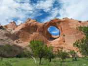
Due to this, the name of the major local landmark, the rock-with-hole-through-it was chosen and rendered in English as "Window Rock."
According to the United States Census Bureau
, the CDP has a total area of 5.2 square miles (13.5 km²), all land.
, and 0.69% from two or more races. Hispanic or Latino of any race were 1.44% of the population.
There were 876 households out of which 51.0% had children under the age of 18 living with them, 43.7% were married couples living together, 29.7% had a female householder with no husband present, and 18.6% were non-families. 15.6% of all households were made up of individuals and 2.4% had someone living alone who was 65 years of age or older. The average household size was 3.42 and the average family size was 3.81.
In the CDP the age distribution of the population shows 36.3% under the age of 18, 10.9% from 18 to 24, 28.7% from 25 to 44, 19.6% from 45 to 64, and 4.5% who were 65 years of age or older. The median age was 27 years. For every 100 females there were 92.6 males. For every 100 females age 18 and over, there were 88.4 males.
The median income for a household in the CDP was $36,885, and the median income for a family was $36,500. Males had a median income of $27,266 versus $26,902 for females. The per capita income
for the CDP was $11,122. About 24.6% of families and 24.6% of the population were below the poverty line, including 28.6% of those under age 18 and 6.8% of those age 65 or over.
.
Window Rock is served by Window Rock Elementary School, Tse Ho Tso Middle School, Window Rock High School
.
Navajo Nation
The Navajo Nation is a semi-autonomous Native American-governed territory covering , occupying all of northeastern Arizona, the southeastern portion of Utah, and northwestern New Mexico...
, the largest territory of a sovereign Native American nation in North America. Window Rock contains the Navajo Nation Council, the Navajo Nation Zoological and Botanical Park, as well as the Navajo Nation World War II
World War II
World War II, or the Second World War , was a global conflict lasting from 1939 to 1945, involving most of the world's nations—including all of the great powers—eventually forming two opposing military alliances: the Allies and the Axis...
Memorial. Window Rock's population was 3,059 at the 2000 census.
Origin of name
John Collier (reformer)
John Collier was an American social reformer and Native American advocate. He served as Commissioner for the Bureau of Indian Affairs in the President Franklin D. Roosevelt administration, from 1933-1945...
, Commissioner of Indian Affairs, chose the site to establish the seat of the Navajo Central Agency. His proposal to make the ceremonial name the official name met with resistance and Navajos soon ridiculed it as "" (~ "into your middle (parts)").
Due to this, the name of the major local landmark, the rock-with-hole-through-it was chosen and rendered in English as "Window Rock."
Geography
Window Rock is located at 35°40′22"N 109°3′44"W (35.672752, -109.062097).According to the United States Census Bureau
United States Census Bureau
The United States Census Bureau is the government agency that is responsible for the United States Census. It also gathers other national demographic and economic data...
, the CDP has a total area of 5.2 square miles (13.5 km²), all land.
Demographics
As of the census of 2000, there were 3,059 people, 876 households, and 713 families residing in the CDP. The population density was 589.3 people per square mile (227.6/km²). There were 998 housing units at an average density of 192.3/sq mi (74.2/km²). The racial makeup of the CDP was 95.46% Native American, 3.17% White, 0.42% Asian, 0.16% African American, 0.03% Pacific Islander, 0.07% from other racesRace (United States Census)
Race and ethnicity in the United States Census, as defined by the Federal Office of Management and Budget and the United States Census Bureau, are self-identification data items in which residents choose the race or races with which they most closely identify, and indicate whether or not they are...
, and 0.69% from two or more races. Hispanic or Latino of any race were 1.44% of the population.
There were 876 households out of which 51.0% had children under the age of 18 living with them, 43.7% were married couples living together, 29.7% had a female householder with no husband present, and 18.6% were non-families. 15.6% of all households were made up of individuals and 2.4% had someone living alone who was 65 years of age or older. The average household size was 3.42 and the average family size was 3.81.
In the CDP the age distribution of the population shows 36.3% under the age of 18, 10.9% from 18 to 24, 28.7% from 25 to 44, 19.6% from 45 to 64, and 4.5% who were 65 years of age or older. The median age was 27 years. For every 100 females there were 92.6 males. For every 100 females age 18 and over, there were 88.4 males.
The median income for a household in the CDP was $36,885, and the median income for a family was $36,500. Males had a median income of $27,266 versus $26,902 for females. The per capita income
Per capita income
Per capita income or income per person is a measure of mean income within an economic aggregate, such as a country or city. It is calculated by taking a measure of all sources of income in the aggregate and dividing it by the total population...
for the CDP was $11,122. About 24.6% of families and 24.6% of the population were below the poverty line, including 28.6% of those under age 18 and 6.8% of those age 65 or over.
Education
Window Rock is a part of Window Rock Unified School DistrictWindow Rock Unified School District
Window Rock Unified School District is a school district within Apache County, Arizona, USA. WRUSD comprises seven schools within a 65-mile radius.WRUSD serves several unincorporated areas, including Fort Defiance, Sawmill, St...
.
Window Rock is served by Window Rock Elementary School, Tse Ho Tso Middle School, Window Rock High School
Window Rock High School
Window Rock High School is a public high school in Fort Defiance, Arizona. WRHS is the only high school in the Window Rock Unified School District.-History:The school district opened by the mid-1950s, with high school students two years later...
.