

Latah County, Idaho
Encyclopedia
Latah County is a county
located in the north central
region of the U.S. state
of Idaho
. The population was 37,244 at the 2010 census. The county seat
and largest city is Moscow
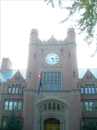
, which is the home of the University of Idaho
, the state's flagship and land-grant university
. The county comprises the majority of the eastern portion of the Palouse
, famous for its rolling hills and rich agriculture. Latah County is the only county in the U.S. established by an act of Congress
.
Latah County (pron. ' ) was created in 1888 and named for Latah Creek
in its northwest corner. The name is Nez Perce
and means "the place of pine trees and pestle", because the tribe found stones here suitable for pulverizing camas
roots and shade under the white pine
trees in which to work.
Latah County comprises the Moscow, ID, Micropolitan Statistical Area
.
, a wide and rolling portion of the middle Columbia basin
.
of 2000, there were 34,935 people, 13,059 households, and 7,770 families residing in the county. The population density
was 32 people per square mile (13/km²). There were 13,838 housing units at an average density of 13 per square mile (5/km²). The racial makeup of the county was 93.94% White
, 0.59% Black
or African American
, 0.75% Native American
, 2.10% Asian
, 0.09% Pacific Islander
, 0.77% from other races
, and 1.76% from two or more races. 2.12% of the population were Hispanic
or Latino
of any race. 20.4% were of German
, 13.5% English
, 8.7% Irish
, 7.8% American
and 5.9% Norwegian ancestry according to Census 2000.
There were 13,059 households out of which 27.90% had children under the age of 18 living with them, 50.50% were married couples
living together, 6.10% had a female householder with no husband present, and 40.50% were non-families. 26.30% of all households were made up of individuals and 6.30% had someone living alone who was 65 years of age or older. The average household size was 2.38 and the average family size was 2.93.
In the county the population was spread out with 20.30% under the age of 18, 24.50% from 18 to 24, 26.90% from 25 to 44, 18.90% from 45 to 64, and 9.50% who were 65 years of age or older. The median age was 28 years. For every 100 females there were 107.50 males. For every 100 females age 18 and over, there were 108.10 males.
The median income for a household in the county was $32,524, and the median income for a family was $46,303. Males had a median income of $34,734 versus $24,886 for females. The per capita income
for the county was $16,690. About 7.90% of families and 16.70% of the population were below the poverty line, including 10.20% of those under age 18 and 5.40% of those age 65 or over. Forty percent of all workers in Latah County work for the University of Idaho
or Washington State University
in nearby Pullman
.
. Faunal species include the Clay-colored sparrow
and Rough-Skinned Newt
.
.
Latah County residents voted in the 2000
and 2004
presidential elections for the Republican candidate at a lower rate than the rest of the state. In 2000, George W. Bush
carried Latah County with 53.3% of the vote; in 2004, this fell to 49.5% of the vote as the Democratic
vote share increased from 37.0% to 48.0%. Ralph Nader
, who received 6.5% of the vote in 2000, was not on the ballot in 2004. In 2008
, Barack Obama
carried the county over John McCain
51.9%-45.1%. In 2006, Latah County voted 55.05% against HJR 2, which amended the Idaho Constitution to outlaw same-sex marriage
; the measure passed with 63.35% of the statewide vote. Blaine County
, a very popular ski resort area and Idaho's one Democratic stronghold, was the one other county to reject HJR 2.
On the precinct level, Democrats generally carry the university city of Moscow
by moderate margins,
and the rural remainder of the county is strongly Republican.
According to the 2000 census, the population in the unincorporated areas of Latah County was 9,044,
which was 25.9% of the county's population.
County (United States)
In the United States, a county is a geographic subdivision of a state , usually assigned some governmental authority. The term "county" is used in 48 of the 50 states; Louisiana is divided into parishes and Alaska into boroughs. Parishes and boroughs are called "county-equivalents" by the U.S...
located in the north central
North Central Idaho
North Central Idaho is an area which spans the central part of the state of Idaho and borders Oregon, Montana, and Washington. It is the southern half of the Idaho Panhandle region and is rich in agriculture and natural resources. Lewis and Clark travelled throughout this area on their journey to...
region of the U.S. state
U.S. state
A U.S. state is any one of the 50 federated states of the United States of America that share sovereignty with the federal government. Because of this shared sovereignty, an American is a citizen both of the federal entity and of his or her state of domicile. Four states use the official title of...
of Idaho
Idaho
Idaho is a state in the Rocky Mountain area of the United States. The state's largest city and capital is Boise. Residents are called "Idahoans". Idaho was admitted to the Union on July 3, 1890, as the 43rd state....
. The population was 37,244 at the 2010 census. The county seat
County seat
A county seat is an administrative center, or seat of government, for a county or civil parish. The term is primarily used in the United States....
and largest city is Moscow
Moscow, Idaho
Moscow is a city in northern Idaho, situated along the Washington/Idaho border. It is the most populous city and county seat of Latah County and the home of the University of Idaho, the land grant institution and primary research university for the state...
, which is the home of the University of Idaho
University of Idaho
The University of Idaho is the State of Idaho's flagship and oldest public university, located in the rural city of Moscow in Latah County in the northern portion of the state...
, the state's flagship and land-grant university
Land-grant university
Land-grant universities are institutions of higher education in the United States designated by each state to receive the benefits of the Morrill Acts of 1862 and 1890....
. The county comprises the majority of the eastern portion of the Palouse
Palouse
The Palouse is a region of the northwestern United States, encompassing parts of southeastern Washington, north central Idaho and, in some definitions, extending south into northeast Oregon. It is a major agricultural area, primarily producing wheat and legumes...
, famous for its rolling hills and rich agriculture. Latah County is the only county in the U.S. established by an act of Congress
United States Congress
The United States Congress is the bicameral legislature of the federal government of the United States, consisting of the Senate and the House of Representatives. The Congress meets in the United States Capitol in Washington, D.C....
.
Latah County (pron. ' ) was created in 1888 and named for Latah Creek
Latah Creek
Latah Creek, also known as Hangman Creek, is a large stream in eastern Washington and north central Idaho in the United States. The creek flows northwest from the Rocky Mountains to Spokane, where it empties into the Spokane River...
in its northwest corner. The name is Nez Perce
Nez Perce language
Nez Perce , also spelled Nez Percé, is a Sahaptian language related to the several dialects of Sahaptin . The Sahaptian sub-family is one of the branches of the Plateau Penutian family...
and means "the place of pine trees and pestle", because the tribe found stones here suitable for pulverizing camas
Camassia
Camassia is a genus of six species native to western North America, from southern British Columbia to northern California, and east to Utah, Wyoming and Montana...
roots and shade under the white pine
Western White Pine
Western White Pine, Pinus monticola in the family Pinaceae, is a species of pine that occurs in the mountains of the western United States and Canada, specifically the Sierra Nevada, the Cascade Range, the Coast Range, and the northern Rocky Mountains. The tree extends down to sea level in many...
trees in which to work.
Latah County comprises the Moscow, ID, Micropolitan Statistical Area
United States micropolitan area
United States Micropolitan Statistical Areas , as defined by the United States Office of Management and Budget, are urban areas in the United States based around a core city or town with a population of 10,000 to 49,999. The micropolitan area designation was created in 2003...
.
Geography
According to the 2000 census, the county has a total area of 1076.89 square miles (2,789.1 km²), of which 1076.65 square miles (2,788.5 km²) (or 99.98%) is land and 0.24 square mile (0.6215971464 km²) (or 0.02%) is water. It is part of the PalousePalouse
The Palouse is a region of the northwestern United States, encompassing parts of southeastern Washington, north central Idaho and, in some definitions, extending south into northeast Oregon. It is a major agricultural area, primarily producing wheat and legumes...
, a wide and rolling portion of the middle Columbia basin
Columbia River
The Columbia River is the largest river in the Pacific Northwest region of North America. The river rises in the Rocky Mountains of British Columbia, Canada, flows northwest and then south into the U.S. state of Washington, then turns west to form most of the border between Washington and the state...
.
Adjacent counties
- Benewah CountyBenewah County, IdahoBenewah County is a county located in the U.S. state of Idaho. Established on January 23, 1915, from sections of Kootenai County, it was named for a chief of the Coeur d'Alene Tribe. As of the 2010 census the county had a population of 9,285. The county seat and largest city is St...
- north - Shoshone CountyShoshone County, IdahoShoshone County is a county located in the U.S. state of Idaho. The county was established in 1864, named for the Native American Shoshone tribe. The population was 12,765 at the 2010 census. Shoshone County is commonly referred to as the Silver Valley, due to its century-old mining history...
- northeast - Clearwater CountyClearwater County, IdahoClearwater County is a county located in the U.S. state of Idaho. Established in 1911, the county was named after the Clearwater River. As of the 2000 Census the county had a population of 8,930 . The county seat is Orofino....
- east - Nez Perce CountyNez Perce County, IdahoNez Perce County [Eng. pron. Nezz Purse] is a county located in the U.S. state of Idaho. The population was 39,265 at the 2010 Census. The county seat is Lewiston. The county is named for the Nez Percé tribe....
- south - Whitman CountyWhitman County, WashingtonWhitman County is a county located in the U.S. state of Washington. As of the 2010 census, the population was 44,776, with the majority living in its largest city, Pullman, home to Washington State University, the state's land-grant university. The county seat is at Colfax.Whitman County was...
, Washington - west
Highways
 - US 95U.S. Route 95 in IdahoIn the U.S. state of Idaho, U.S. Route 95 is a north–south highway near the western border of the state, stretching from Oregon to British Columbia for over .-Route description:...
 - SH-3Idaho State Highway 3Idaho State Highway 3 is a state highway in northern Idaho connecting US 12 near Spalding with I-90 near Rose Lake. It is long and runs north–south.-Route description:...
 - SH-6Idaho State Highway 6Idaho State Highway 6 is a state highway in northern Idaho running from the Washington state line near Potlatch to Santa. It is long and runs north-south.-Route description:...
 - SH-8Idaho State Highway 8State Highway 8 is an Idaho state highway in Latah and Clearwater counties, running from the Washington state line in Moscow to Elk River. It is in length, and runs primarily east–west.-Route description:...
 - SH-9Idaho State Highway 9State Highway 9 is a state highway in Latah County, in the U.S. state of Idaho. It runs from SH-8 near Deary, north to SH-6 near Harvard.-Route description:...
 - SH-99
Demographics
As of the censusCensus
A census is the procedure of systematically acquiring and recording information about the members of a given population. It is a regularly occurring and official count of a particular population. The term is used mostly in connection with national population and housing censuses; other common...
of 2000, there were 34,935 people, 13,059 households, and 7,770 families residing in the county. The population density
Population density
Population density is a measurement of population per unit area or unit volume. It is frequently applied to living organisms, and particularly to humans...
was 32 people per square mile (13/km²). There were 13,838 housing units at an average density of 13 per square mile (5/km²). The racial makeup of the county was 93.94% White
Race (United States Census)
Race and ethnicity in the United States Census, as defined by the Federal Office of Management and Budget and the United States Census Bureau, are self-identification data items in which residents choose the race or races with which they most closely identify, and indicate whether or not they are...
, 0.59% Black
Race (United States Census)
Race and ethnicity in the United States Census, as defined by the Federal Office of Management and Budget and the United States Census Bureau, are self-identification data items in which residents choose the race or races with which they most closely identify, and indicate whether or not they are...
or African American
Race (United States Census)
Race and ethnicity in the United States Census, as defined by the Federal Office of Management and Budget and the United States Census Bureau, are self-identification data items in which residents choose the race or races with which they most closely identify, and indicate whether or not they are...
, 0.75% Native American
Race (United States Census)
Race and ethnicity in the United States Census, as defined by the Federal Office of Management and Budget and the United States Census Bureau, are self-identification data items in which residents choose the race or races with which they most closely identify, and indicate whether or not they are...
, 2.10% Asian
Race (United States Census)
Race and ethnicity in the United States Census, as defined by the Federal Office of Management and Budget and the United States Census Bureau, are self-identification data items in which residents choose the race or races with which they most closely identify, and indicate whether or not they are...
, 0.09% Pacific Islander
Race (United States Census)
Race and ethnicity in the United States Census, as defined by the Federal Office of Management and Budget and the United States Census Bureau, are self-identification data items in which residents choose the race or races with which they most closely identify, and indicate whether or not they are...
, 0.77% from other races
Race (United States Census)
Race and ethnicity in the United States Census, as defined by the Federal Office of Management and Budget and the United States Census Bureau, are self-identification data items in which residents choose the race or races with which they most closely identify, and indicate whether or not they are...
, and 1.76% from two or more races. 2.12% of the population were Hispanic
Race (United States Census)
Race and ethnicity in the United States Census, as defined by the Federal Office of Management and Budget and the United States Census Bureau, are self-identification data items in which residents choose the race or races with which they most closely identify, and indicate whether or not they are...
or Latino
Race (United States Census)
Race and ethnicity in the United States Census, as defined by the Federal Office of Management and Budget and the United States Census Bureau, are self-identification data items in which residents choose the race or races with which they most closely identify, and indicate whether or not they are...
of any race. 20.4% were of German
Germans
The Germans are a Germanic ethnic group native to Central Europe. The English term Germans has referred to the German-speaking population of the Holy Roman Empire since the Late Middle Ages....
, 13.5% English
English people
The English are a nation and ethnic group native to England, who speak English. The English identity is of early mediaeval origin, when they were known in Old English as the Anglecynn. England is now a country of the United Kingdom, and the majority of English people in England are British Citizens...
, 8.7% Irish
Irish people
The Irish people are an ethnic group who originate in Ireland, an island in northwestern Europe. Ireland has been populated for around 9,000 years , with the Irish people's earliest ancestors recorded having legends of being descended from groups such as the Nemedians, Fomorians, Fir Bolg, Tuatha...
, 7.8% American
United States
The United States of America is a federal constitutional republic comprising fifty states and a federal district...
and 5.9% Norwegian ancestry according to Census 2000.
There were 13,059 households out of which 27.90% had children under the age of 18 living with them, 50.50% were married couples
Marriage
Marriage is a social union or legal contract between people that creates kinship. It is an institution in which interpersonal relationships, usually intimate and sexual, are acknowledged in a variety of ways, depending on the culture or subculture in which it is found...
living together, 6.10% had a female householder with no husband present, and 40.50% were non-families. 26.30% of all households were made up of individuals and 6.30% had someone living alone who was 65 years of age or older. The average household size was 2.38 and the average family size was 2.93.
In the county the population was spread out with 20.30% under the age of 18, 24.50% from 18 to 24, 26.90% from 25 to 44, 18.90% from 45 to 64, and 9.50% who were 65 years of age or older. The median age was 28 years. For every 100 females there were 107.50 males. For every 100 females age 18 and over, there were 108.10 males.
The median income for a household in the county was $32,524, and the median income for a family was $46,303. Males had a median income of $34,734 versus $24,886 for females. The per capita income
Per capita income
Per capita income or income per person is a measure of mean income within an economic aggregate, such as a country or city. It is calculated by taking a measure of all sources of income in the aggregate and dividing it by the total population...
for the county was $16,690. About 7.90% of families and 16.70% of the population were below the poverty line, including 10.20% of those under age 18 and 5.40% of those age 65 or over. Forty percent of all workers in Latah County work for the University of Idaho
University of Idaho
The University of Idaho is the State of Idaho's flagship and oldest public university, located in the rural city of Moscow in Latah County in the northern portion of the state...
or Washington State University
Washington State University
Washington State University is a public research university based in Pullman, Washington, in the Palouse region of the Pacific Northwest. Founded in 1890, WSU is the state's original and largest land-grant university...
in nearby Pullman
Pullman, Washington
Pullman is the largest city in Whitman County, Washington, United States. The population was 24,675 at the 2000 census and 29,799 according to the 2010 census...
.
Flora and fauna
There are numerous species of plants and animals within Latah County. There are a variety of tree species within the county including Western White PineWestern White Pine
Western White Pine, Pinus monticola in the family Pinaceae, is a species of pine that occurs in the mountains of the western United States and Canada, specifically the Sierra Nevada, the Cascade Range, the Coast Range, and the northern Rocky Mountains. The tree extends down to sea level in many...
. Faunal species include the Clay-colored sparrow
Clay-colored Sparrow
The Clay-colored Sparrow is a small sparrow of North America.-Overview:Adults have light brown upperparts and pale underparts, with darker streaks on the back. They have a pale crown stripe on a dark brown crown, a white line over the eyes, a dark line through the eyes, a light brown cheek patch...
and Rough-Skinned Newt
Rough-skinned Newt
The rough-skinned newt is a North American newt known for its strong poison.- Toxicity :Many newts produce toxins to avoid predation, but the toxins of the genus Taricha are particularly potent...
.
Government and politics
Latah County has long been one of the most politically competitive counties in Idaho, while the state as a whole is strongly RepublicanRepublican Party (United States)
The Republican Party is one of the two major contemporary political parties in the United States, along with the Democratic Party. Founded by anti-slavery expansion activists in 1854, it is often called the GOP . The party's platform generally reflects American conservatism in the U.S...
.
Latah County residents voted in the 2000
United States presidential election, 2000
The United States presidential election of 2000 was a contest between Republican candidate George W. Bush, then-governor of Texas and son of former president George H. W. Bush , and Democratic candidate Al Gore, then-Vice President....
and 2004
United States presidential election, 2004
The United States presidential election of 2004 was the United States' 55th quadrennial presidential election. It was held on Tuesday, November 2, 2004. Republican Party candidate and incumbent President George W. Bush defeated Democratic Party candidate John Kerry, the then-junior U.S. Senator...
presidential elections for the Republican candidate at a lower rate than the rest of the state. In 2000, George W. Bush
George W. Bush
George Walker Bush is an American politician who served as the 43rd President of the United States, from 2001 to 2009. Before that, he was the 46th Governor of Texas, having served from 1995 to 2000....
carried Latah County with 53.3% of the vote; in 2004, this fell to 49.5% of the vote as the Democratic
Democratic Party (United States)
The Democratic Party is one of two major contemporary political parties in the United States, along with the Republican Party. The party's socially liberal and progressive platform is largely considered center-left in the U.S. political spectrum. The party has the lengthiest record of continuous...
vote share increased from 37.0% to 48.0%. Ralph Nader
Ralph Nader
Ralph Nader is an American political activist, as well as an author, lecturer, and attorney. Areas of particular concern to Nader include consumer protection, humanitarianism, environmentalism, and democratic government....
, who received 6.5% of the vote in 2000, was not on the ballot in 2004. In 2008
United States presidential election, 2008
The United States presidential election of 2008 was the 56th quadrennial presidential election. It was held on November 4, 2008. Democrat Barack Obama, then the junior United States Senator from Illinois, defeated Republican John McCain, the senior U.S. Senator from Arizona. Obama received 365...
, Barack Obama
Barack Obama
Barack Hussein Obama II is the 44th and current President of the United States. He is the first African American to hold the office. Obama previously served as a United States Senator from Illinois, from January 2005 until he resigned following his victory in the 2008 presidential election.Born in...
carried the county over John McCain
John McCain
John Sidney McCain III is the senior United States Senator from Arizona. He was the Republican nominee for president in the 2008 United States election....
51.9%-45.1%. In 2006, Latah County voted 55.05% against HJR 2, which amended the Idaho Constitution to outlaw same-sex marriage
Same-sex marriage
Same-sex marriage is marriage between two persons of the same biological sex or social gender. Supporters of legal recognition for same-sex marriage typically refer to such recognition as marriage equality....
; the measure passed with 63.35% of the statewide vote. Blaine County
Blaine County, Idaho
Blaine County is a county located in the U.S. state of Idaho. As of the 2010 Census the county had a population of 21,376. The county seat and largest city is Hailey. The county is home to the Sun Valley ski resort....
, a very popular ski resort area and Idaho's one Democratic stronghold, was the one other county to reject HJR 2.
On the precinct level, Democrats generally carry the university city of Moscow
Moscow, Idaho
Moscow is a city in northern Idaho, situated along the Washington/Idaho border. It is the most populous city and county seat of Latah County and the home of the University of Idaho, the land grant institution and primary research university for the state...
by moderate margins,
and the rural remainder of the county is strongly Republican.
Cities
| Name | Population (2000) |
Elevation | Zip Code | Coordinates | Notes |
|---|---|---|---|---|---|
| Bovill Bovill, Idaho Bovill is a city in Latah County, Idaho, United States. The population was 305 at the 2000 census.-History:Bovill was named for a settler.The Bovill Opera House, at 2nd and Pine, was listed on the National Register of Historic Places in 2010.-Geography:... |
305 | 2874 ft - (876 m) | 83806 | 46°51′33"N 116°23′40"W | |
| Deary Deary, Idaho Deary is a city in Latah County, Idaho, United States. The population was 552 at the 2000 census.-Geography:Deary is located at .According to the United States Census Bureau, the city has a total area of , all of it land.... |
552 | 2874 ft - (876 m) | 83823 | 46°48′0"N 116°33′31"W | |
| Genesee Genesee, Idaho Genesee is a city in Latah County, Idaho, United States. The population was 955 at the 2010 census.-Geography:Genesee is located at ., in the Palouse region, approximately south of Moscow, about halfway to Lewiston... |
946 | 2680 ft - (817 m) | 83832 | 46°33′4"N 116°55′39"W | |
| Juliaetta Juliaetta, Idaho Juliaetta is a city in Latah County, Idaho, United States. The population was 609 at the 2000 census.-Geography:Juliaetta is located at and lies approximately 2 miles north of the Nez Perce Indian Reservation... |
609 | 1171 ft - (357 m) | 83535 | 46°34′40"N 116°42′28"W | |
| Kendrick Kendrick, Idaho Kendrick is a city in Latah County, Idaho, United States. The population was 369 at the 2000 census.-Geography:Kendrick is located at , near the Potlatch River.... |
369 | 1240 ft - (378 m) | 83537 | 46°36′52"N 116°39′1"W | |
| Moscow Moscow, Idaho Moscow is a city in northern Idaho, situated along the Washington/Idaho border. It is the most populous city and county seat of Latah County and the home of the University of Idaho, the land grant institution and primary research university for the state... |
21,291 | 2579 ft - (786 m) | 83843 | 46°43′54"N 116°59′50"W | county seat County seat A county seat is an administrative center, or seat of government, for a county or civil parish. The term is primarily used in the United States.... |
| Onaway Onaway, Idaho Onaway is a city in Latah County, Idaho, United States. The population was 230 at the 2000 census.The name sources from the mill works at Potlatch who would stop at the bars after work... |
230 | 2621 ft - (799 m) | 83855 | 46°55′43"N 116°53′21"W | |
| Potlatch Potlatch, Idaho Potlatch is a city in Latah County, Idaho, United States. The population was 791 at the 2000 census.-History:Potlatch was founded in 1905 as a company town by the Potlach Corporation. The townsite was chosen because of proximity to Potlatch Corporation's large holdings of western white pine on the... |
791 | 2546 ft - (776 m) | 83855 | 46°55′20"N 116°53′52"W | |
| Troy Troy, Idaho Troy is a city in Latah County, Idaho, United States. Located in the eastern part of the Palouse region, its population was 862 at the 2010 census.-Geography:Troy is located at ., east of Moscow on State Highway 8.... |
798 | 2487 ft - (758 m) | 83871 | 46°44′19"N 116°46′15"W | |
| TOTAL | 25,891 |
Unincorporated community
- ViolaViola, IdahoViola is an unincorporated community in Latah County, Idaho, United States. Viola has a post office with a ZIP code of 83872. Viola lies on U.S. Route 95 south of its intersection with Idaho State Highway 66 and north of Moscow.-References:...
According to the 2000 census, the population in the unincorporated areas of Latah County was 9,044,
which was 25.9% of the county's population.
External links
- Latah County - official site
- Access Idaho - Latah County
- Latah County Historical Society
- Latah Trail Project
- National Register of Historic Places - Latah County