

Shoshone County, Idaho
Encyclopedia
Shoshone County is a county located in the U.S. state
of Idaho
. The county was established in 1864, named for the Native American
Shoshone
tribe. The population was 12,765 at the 2010 census. Shoshone County is commonly referred to as the Silver Valley, due to its century-old mining history. The Silver Valley is famous nationwide for the vast amounts of silver
, lead
, and zinc
mined from it.
 Hard rock miners in Shoshone County protested wage cuts with a strike in 1892. After several lost their lives in a shooting war
provoked by discovery of a company spy
, the U.S. army forced an end to the strike. Hostilities erupted once again
in 1899 when, in response to the company firing seventeen men for joining the union
, the miners dynamited the Bunker Hill & Sullivan mill
. Again, lives were lost, and the army intervened.
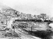
Much of the county was burned in the Great Fire of 1910
, including part of the town of Wallace
.
and Democratic Senatorial candidate Larry LaRocco
while voting against Barack Obama
by an eight point margin.
of 2000, there were 13,771 people, 5,906 households, and 3,856 families residing in the county. The population density
was 5 people per square mile (2/km²). There were 7,057 housing units at an average density of 3 per square mile (1/km²). The racial makeup of the county was 95.84% White
, 0.11% Black
or African American
, 1.52% Native American
, 0.23% Asian
, 0.07% Pacific Islander
, 0.49% from other races
, and 1.74% from two or more races. 1.93% of the population were Hispanic
or Latino
of any race. 22.1% were of German
, 14.0% American
, 11.3% English
, 9.7% Irish
and 5.9% Norwegian ancestry according to Census 2000.
There were 5,906 households out of which 26.70% had children under the age of 18 living with them, 52.70% were married couples
living together, 8.10% had a female householder with no husband present, and 34.70% were non-families. 29.40% of all households were made up of individuals and 13.60% had someone living alone who was 65 years of age or older. The average household size was 2.30 and the average family size was 2.82.
In the county the population was spread out with 22.90% under the age of 18, 6.70% from 18 to 24, 25.50% from 25 to 44, 27.40% from 45 to 64, and 17.40% who were 65 years of age or older. The median age was 42 years. For every 100 females there were 99.40 males. For every 100 females age 18 and over, there were 97.00 males.
The median income for a household in the county was $28,535, and the median income for a family was $35,694. Males had a median income of $30,439 versus $18,831 for females. The per capita income
for the county was $15,934. About 12.40% of families and 16.40% of the population were below the poverty line, including 21.80% of those under age 18 and 10.00% of those age 65 or over.
U.S. state
A U.S. state is any one of the 50 federated states of the United States of America that share sovereignty with the federal government. Because of this shared sovereignty, an American is a citizen both of the federal entity and of his or her state of domicile. Four states use the official title of...
of Idaho
Idaho
Idaho is a state in the Rocky Mountain area of the United States. The state's largest city and capital is Boise. Residents are called "Idahoans". Idaho was admitted to the Union on July 3, 1890, as the 43rd state....
. The county was established in 1864, named for the Native American
Native Americans in the United States
Native Americans in the United States are the indigenous peoples in North America within the boundaries of the present-day continental United States, parts of Alaska, and the island state of Hawaii. They are composed of numerous, distinct tribes, states, and ethnic groups, many of which survive as...
Shoshone
Shoshone
The Shoshone or Shoshoni are a Native American tribe in the United States with three large divisions: the Northern, the Western and the Eastern....
tribe. The population was 12,765 at the 2010 census. Shoshone County is commonly referred to as the Silver Valley, due to its century-old mining history. The Silver Valley is famous nationwide for the vast amounts of silver
Silver
Silver is a metallic chemical element with the chemical symbol Ag and atomic number 47. A soft, white, lustrous transition metal, it has the highest electrical conductivity of any element and the highest thermal conductivity of any metal...
, lead
Lead
Lead is a main-group element in the carbon group with the symbol Pb and atomic number 82. Lead is a soft, malleable poor metal. It is also counted as one of the heavy metals. Metallic lead has a bluish-white color after being freshly cut, but it soon tarnishes to a dull grayish color when exposed...
, and zinc
Zinc
Zinc , or spelter , is a metallic chemical element; it has the symbol Zn and atomic number 30. It is the first element in group 12 of the periodic table. Zinc is, in some respects, chemically similar to magnesium, because its ion is of similar size and its only common oxidation state is +2...
mined from it.
Geography
According to the 2000 census, the county has a total area of 2635.5 square miles (6,825.9 km²), of which 2633.91 square miles (6,821.8 km²) (or 99.94%) is land and 1.59 square miles (4.1 km²) (or 0.06%) is water.Adjacent counties
- Bonner CountyBonner County, IdahoBonner County is a county located in the northern part of the U.S. state of Idaho. Established in 1907, it was named for Edwin L. Bonner, a ferry operator. As of the 2010 census, the county had a population of 40,877. The county seat and largest city is Sandpoint.-History:Bonner County was formed...
- north - Kootenai CountyKootenai County, IdahoKootenai County is a county located in the U.S. state of Idaho. The county was established in 1864, named after Kootenai tribe. The entire county comprises the Coeur d'Alene, Idaho Metropolitan Statistical Area. The population was 138,494 at the 2010 census...
- west - Benewah CountyBenewah County, IdahoBenewah County is a county located in the U.S. state of Idaho. Established on January 23, 1915, from sections of Kootenai County, it was named for a chief of the Coeur d'Alene Tribe. As of the 2010 census the county had a population of 9,285. The county seat and largest city is St...
- west - Latah CountyLatah County, IdahoLatah County is a county located in the north central region of the U.S. state of Idaho. The population was 37,244 at the 2010 census. The county seat and largest city is Moscow, which is the home of the University of Idaho, the state's flagship and land-grant university...
- southwest - Clearwater CountyClearwater County, IdahoClearwater County is a county located in the U.S. state of Idaho. Established in 1911, the county was named after the Clearwater River. As of the 2000 Census the county had a population of 8,930 . The county seat is Orofino....
- south - Mineral CountyMineral County, Montana-Demographics:As of the census of 2000, there were 3,884 people, 1,584 households, and 1,067 families residing in the county. The population density was 3 people per square mile . There were 1,961 housing units at an average density of 2 per square mile...
, MontanaMontanaMontana is a state in the Western United States. The western third of Montana contains numerous mountain ranges. Smaller, "island ranges" are found in the central third of the state, for a total of 77 named ranges of the Rocky Mountains. This geographical fact is reflected in the state's name,...
- east - Sanders CountySanders County, MontanaSanders County is a county located in the U.S. state of Montana. As of 2010, the population was 11,413. Its county seat is Thompson Falls.-Geography:According to the U.S...
, MontanaMontanaMontana is a state in the Western United States. The western third of Montana contains numerous mountain ranges. Smaller, "island ranges" are found in the central third of the state, for a total of 77 named ranges of the Rocky Mountains. This geographical fact is reflected in the state's name,...
- east
National protected areas
- Clearwater National ForestClearwater National ForestClearwater National Forest is located in North Central Idaho in the northwestern United States. The forest is bounded on the east by the state of Montana, on the north by the Idaho Panhandle National Forest, and on the south and west by the Nez Perce National Forest and Palouse Prairie.]The forest...
(part) - Coeur d'Alene National ForestCoeur d'Alene National ForestThe Coeur d'Alene is a U.S. National Forest located in the Idaho panhandle and is one of three forests that are aggregated into the Idaho Panhandle National Forest . Coeur d'Alene National Forest is located in Shoshone, Kootenai, and Bonner counties in northern Idaho...
(part) - St. Joe National ForestSt. Joe National ForestThe St. Joe National Forest is a U.S. National Forest located in the Idaho panhandle and is one of three forests that are aggregated into the Idaho Panhandle National Forest . In descending order of land area St. Joe National Forest is located in parts of Shoshone, Latah, Clearwater, and Benewah...
(part)
History
Coeur d'Alene, Idaho labor strike of 1892
There were two related incidents between miners and mine owners in Coeur d'Alene, Idaho: the labor strike of 1892, and the labor confrontation of 1899....
provoked by discovery of a company spy
Labor spies
Labor spies are persons recruited or employed for the purpose of gathering intelligence, committing sabotage, sowing dissent, or engaging in other similar activities, typically within the context of an employer/labor organization relationship....
, the U.S. army forced an end to the strike. Hostilities erupted once again
Coeur d'Alene, Idaho labor confrontation of 1899
There were two related incidents between miners and mine owners in Coeur d'Alene: the Coeur d'Alene, Idaho labor strike of 1892, and the Coeur d'Alene, Idaho labor confrontation of 1899....
in 1899 when, in response to the company firing seventeen men for joining the union
Western Federation of Miners
The Western Federation of Miners was a radical labor union that gained a reputation for militancy in the mines of the western United States and British Columbia. Its efforts to organize both hard rock miners and smelter workers brought it into sharp conflicts – and often pitched battles...
, the miners dynamited the Bunker Hill & Sullivan mill
Bunker Hill Mining Company
The Bunker Hill Mining Company was a mining company with facilities in Wardner, Idaho and surrounding areas.-History:When the mining boom began in the Coeur d'Alene, Idaho mining district, the area was lightly inhabited...
. Again, lives were lost, and the army intervened.
Much of the county was burned in the Great Fire of 1910
Great Fire of 1910
The Great Fire of 1910 was a wildfire which burned about three million acres in northeast Washington, northern Idaho , and western Montana...
, including part of the town of Wallace
Wallace, Idaho
Wallace is a historic city in the Panhandle region of the U.S. state of Idaho and the county seat of Shoshone County in the Silver Valley mining district...
.
Law/Government and Politics
Shoshone County used to be a Democratic-leaning county in the past but in recent years has voted for Republican candidates federally, while still voting for Democratic candidates locally and state-wide. Shoshone County voted for Democratic Gubernatorial candidate Jerry BradyJerry Brady
Jerry Michael Brady is an Idaho politician and owns a newspaper that is distributed in southeast Idaho...
and Democratic Senatorial candidate Larry LaRocco
Larry LaRocco
Larry LaRocco is a Democratic politician from the US state of Idaho, who served two terms in the U.S. House of Representatives. LaRocco was defeated by Republican Jim Risch for the open U.S. Senate seat in Idaho in 2008....
while voting against Barack Obama
Barack Obama
Barack Hussein Obama II is the 44th and current President of the United States. He is the first African American to hold the office. Obama previously served as a United States Senator from Illinois, from January 2005 until he resigned following his victory in the 2008 presidential election.Born in...
by an eight point margin.
Demographics
As of the censusCensus
A census is the procedure of systematically acquiring and recording information about the members of a given population. It is a regularly occurring and official count of a particular population. The term is used mostly in connection with national population and housing censuses; other common...
of 2000, there were 13,771 people, 5,906 households, and 3,856 families residing in the county. The population density
Population density
Population density is a measurement of population per unit area or unit volume. It is frequently applied to living organisms, and particularly to humans...
was 5 people per square mile (2/km²). There were 7,057 housing units at an average density of 3 per square mile (1/km²). The racial makeup of the county was 95.84% White
Race (United States Census)
Race and ethnicity in the United States Census, as defined by the Federal Office of Management and Budget and the United States Census Bureau, are self-identification data items in which residents choose the race or races with which they most closely identify, and indicate whether or not they are...
, 0.11% Black
Race (United States Census)
Race and ethnicity in the United States Census, as defined by the Federal Office of Management and Budget and the United States Census Bureau, are self-identification data items in which residents choose the race or races with which they most closely identify, and indicate whether or not they are...
or African American
Race (United States Census)
Race and ethnicity in the United States Census, as defined by the Federal Office of Management and Budget and the United States Census Bureau, are self-identification data items in which residents choose the race or races with which they most closely identify, and indicate whether or not they are...
, 1.52% Native American
Race (United States Census)
Race and ethnicity in the United States Census, as defined by the Federal Office of Management and Budget and the United States Census Bureau, are self-identification data items in which residents choose the race or races with which they most closely identify, and indicate whether or not they are...
, 0.23% Asian
Race (United States Census)
Race and ethnicity in the United States Census, as defined by the Federal Office of Management and Budget and the United States Census Bureau, are self-identification data items in which residents choose the race or races with which they most closely identify, and indicate whether or not they are...
, 0.07% Pacific Islander
Race (United States Census)
Race and ethnicity in the United States Census, as defined by the Federal Office of Management and Budget and the United States Census Bureau, are self-identification data items in which residents choose the race or races with which they most closely identify, and indicate whether or not they are...
, 0.49% from other races
Race (United States Census)
Race and ethnicity in the United States Census, as defined by the Federal Office of Management and Budget and the United States Census Bureau, are self-identification data items in which residents choose the race or races with which they most closely identify, and indicate whether or not they are...
, and 1.74% from two or more races. 1.93% of the population were Hispanic
Race (United States Census)
Race and ethnicity in the United States Census, as defined by the Federal Office of Management and Budget and the United States Census Bureau, are self-identification data items in which residents choose the race or races with which they most closely identify, and indicate whether or not they are...
or Latino
Race (United States Census)
Race and ethnicity in the United States Census, as defined by the Federal Office of Management and Budget and the United States Census Bureau, are self-identification data items in which residents choose the race or races with which they most closely identify, and indicate whether or not they are...
of any race. 22.1% were of German
Germans
The Germans are a Germanic ethnic group native to Central Europe. The English term Germans has referred to the German-speaking population of the Holy Roman Empire since the Late Middle Ages....
, 14.0% American
United States
The United States of America is a federal constitutional republic comprising fifty states and a federal district...
, 11.3% English
English people
The English are a nation and ethnic group native to England, who speak English. The English identity is of early mediaeval origin, when they were known in Old English as the Anglecynn. England is now a country of the United Kingdom, and the majority of English people in England are British Citizens...
, 9.7% Irish
Irish people
The Irish people are an ethnic group who originate in Ireland, an island in northwestern Europe. Ireland has been populated for around 9,000 years , with the Irish people's earliest ancestors recorded having legends of being descended from groups such as the Nemedians, Fomorians, Fir Bolg, Tuatha...
and 5.9% Norwegian ancestry according to Census 2000.
There were 5,906 households out of which 26.70% had children under the age of 18 living with them, 52.70% were married couples
Marriage
Marriage is a social union or legal contract between people that creates kinship. It is an institution in which interpersonal relationships, usually intimate and sexual, are acknowledged in a variety of ways, depending on the culture or subculture in which it is found...
living together, 8.10% had a female householder with no husband present, and 34.70% were non-families. 29.40% of all households were made up of individuals and 13.60% had someone living alone who was 65 years of age or older. The average household size was 2.30 and the average family size was 2.82.
In the county the population was spread out with 22.90% under the age of 18, 6.70% from 18 to 24, 25.50% from 25 to 44, 27.40% from 45 to 64, and 17.40% who were 65 years of age or older. The median age was 42 years. For every 100 females there were 99.40 males. For every 100 females age 18 and over, there were 97.00 males.
The median income for a household in the county was $28,535, and the median income for a family was $35,694. Males had a median income of $30,439 versus $18,831 for females. The per capita income
Per capita income
Per capita income or income per person is a measure of mean income within an economic aggregate, such as a country or city. It is calculated by taking a measure of all sources of income in the aggregate and dividing it by the total population...
for the county was $15,934. About 12.40% of families and 16.40% of the population were below the poverty line, including 21.80% of those under age 18 and 10.00% of those age 65 or over.
Cities
- KelloggKellogg, IdahoKellogg is a city in the Silver Valley of Shoshone County, Idaho, United States, in the Idaho Panhandle region. The city lies near the Coeur d'Alene National Forest and about east-southeast of Coeur d'Alene along Interstate 90...
- MullanMullan, IdahoMullan is a city located in a sheltered canyon of the Coeur d'Alene Mountains in Shoshone County in the northern part of the U.S. state of Idaho. The population was 840 at the 2000 census and decreased to 692 at the 2010 census. The city is in the east end of the Silver Valley mining district; the...
- OsburnOsburn, IdahoOsburn is a city in Shoshone County, Idaho, United States. The population was 1,555 at the 2010 census.-Geography:Osburn is located at .According to the United States Census Bureau, the city has a total area of , all land....
- PinehurstPinehurst, IdahoPinehurst is a city in Shoshone County, Idaho, United States. The population was 1,619 at the 2010 census.-Geography:Pinehurst is located at ....
- SmeltervilleSmelterville, IdahoSmelterville is a city in Shoshone County, Idaho, United States. The population was 627 at the 2010 census. Smelterville has recently gained prominence in Shoshone County due to the addition of a Wal-Mart store.-Geography:...
- WallaceWallace, IdahoWallace is a historic city in the Panhandle region of the U.S. state of Idaho and the county seat of Shoshone County in the Silver Valley mining district...
- WardnerWardner, IdahoWardner is a city in Shoshone County, Idaho, United States. The population was 188 at the 2010 census.-Geography:Wardner is located at .According to the United States Census Bureau, the city has a total area of , all the land....
Unincorporated communities
- AveryAvery, IdahoAvery is a small unincorporated town nestled in the St. Joe River Valley in Shoshone County, Idaho, United States. Avery is located in the middle of the St. Joe District of the Idaho Panhandle National Forest...
- Big CreekBig Creek, IdahoBig Creek is an unincorporated community in Shoshone County, Idaho, United States, outside Kellogg. It is home to two large mines: the Crescent and Sunshine mines. The Sunshine mine is one of the largest producers of silver; in its history it produced more silver than the famous Comstock Lode in...
- BurkeBurke, IdahoBurke is a ghost town in Burke-Canyon in Shoshone County, Idaho, United States. Once a thriving silver and lead town, it is now far smaller than at its height. In 2002, about 300 people lived in or nearby Burke Canyon...
- CataldoCataldo, IdahoCataldo is an unincorporated community in Kootenai and Shoshone counties in the U.S. state of Idaho. It is located at , at an altitude of 2,139 feet ....
- ClarkiaClarkia, IdahoClarkia is a small unincorporated town in the southwestern corner of Shoshone County, Idaho United States. It is surrounded by publicly and privately managed forest lands of Douglas-fir, Ponderosa Pine, and Western Larch. Located just to the east of State Highway 3, the town is in the drainage...
- MurrayMurray, IdahoMurray is an unincorporated community in Shoshone County, Idaho, United States.Mines operated in the area from the 1880s to the 1950s. A Northern Pacific railroad line served the community for two years during the 1910s.-References:...
- Pine CreekPine Creek, IdahoPine Creek is an unincorporated community in Shoshone County, Idaho, United States, about 4 miles south of Pinehurst. At one point Pine Creek had several working mines including the Independence.-References:...
- KingstonKingston, IdahoKingston is an unincorporated community in Shoshone County, Idaho, United States. Kingston is located along Interstate 90 northwest of Pinehurst. Kingston has a post office with ZIP code 83839....
- SilvertonSilverton, IdahoSilverton is an unincorporated community in Shoshone County, Idaho, United States, located one mile west of Wallace....
Ski areas
- Silver Mountain
- Lookout PassLookout Pass Ski and Recreation AreaLookout Pass Ski and Recreation Area is a ski area at Lookout Pass in northern Idaho on the Montana border, 4 miles east of Mullan on Interstate 90. It has a summit elevation of 5650 feet on Runt Mountain with a vertical drop of 1150 feet on the northeast-facing slopes...