

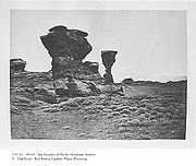
Laramie Plains
Encyclopedia
Wyoming
Wyoming is a state in the mountain region of the Western United States. The western two thirds of the state is covered mostly with the mountain ranges and rangelands in the foothills of the Eastern Rocky Mountains, while the eastern third of the state is high elevation prairie known as the High...
in the United States
United States
The United States of America is a federal constitutional republic comprising fifty states and a federal district...
. The plains extend along the upper basin of the Laramie River
Laramie River
The Laramie River is a tributary of the North Platte River, approximately long, in the U.S. states of Colorado and Wyoming.It rises in northern Colorado, in the Roosevelt National Forest in the Front Range, in western Larimer County...
on the east side of the Medicine Bow Range. The city of Laramie
Laramie, Wyoming
Laramie is a city in and the county seat of Albany County, Wyoming, United States. The population was 30,816 at the . Located on the Laramie River in southeastern Wyoming, the city is west of Cheyenne, at the junction of Interstate 80 and U.S. Route 287....
is the largest community in the valley. The plains are separated from the Great Plains
Great Plains
The Great Plains are a broad expanse of flat land, much of it covered in prairie, steppe and grassland, which lies west of the Mississippi River and east of the Rocky Mountains in the United States and Canada. This area covers parts of the U.S...
to the east by the Laramie Mountains
Laramie Mountains
The Laramie Mountains are a range of moderately high peaks on the eastern edge of the Rocky Mountains in the U.S states of Wyoming and Colorado. The range is the northernmost extension of the line of the ranges along the eastern side of the Rockies, and in particular of the higher peaks of the...
, spur of the Front Range
Front Range
The Front Range is a mountain range of the Southern Rocky Mountains of North America located in the north-central portion of the U.S. State of Colorado and southeastern portion of the U.S. State of Wyoming. It is the first mountain range encountered moving west along the 40th parallel north across...
that extends northward from Larimer County, Colorado
Larimer County, Colorado
Larimer County is the seventh most populous and the ninth most extensive of the 64 counties of the State of Colorado of the United States. The county is located at the northern end of the Front Range, at the edge of the Colorado Eastern Plains along the border with Wyoming...
west of Cheyenne
Cheyenne, Wyoming
Cheyenne is the capital and most populous city of the U.S. state of Wyoming and the county seat of Laramie County. It is the principal city of the Cheyenne, Wyoming, Metropolitan Statistical Area which encompasses all of Laramie County. The population is 59,466 at the 2010 census. Cheyenne is the...
. The high altitude of the plains makes for a cold climate and relatively short growing season. Unsuitable to most cultivation, the plains have historically been the site of livestock
Livestock
Livestock refers to one or more domesticated animals raised in an agricultural setting to produce commodities such as food, fiber and labor. The term "livestock" as used in this article does not include poultry or farmed fish; however the inclusion of these, especially poultry, within the meaning...
raising (primarily sheep and cattle
Cattle
Cattle are the most common type of large domesticated ungulates. They are a prominent modern member of the subfamily Bovinae, are the most widespread species of the genus Bos, and are most commonly classified collectively as Bos primigenius...
).
Geography
In 1842 and 1843 John Charles Fremont explored in Wyoming and submitted reports and maps to Congress afterward. He apparently followed local usage and labeled the plains surrounded by mountains in southeast Wyoming “Laramie Plains.” His 1842 map used the term twice at the northern and southern extremes: just south of the Laramie Mountains near Red Buttes (near present day CasperCasper, Wyoming
Casper is the county seat of Natrona County, Wyoming, United States.. Casper is the second-largest city in Wyoming , according to the 2010 census, with a population of 55,316...
) in the north and straddling the Laramie River
Laramie River
The Laramie River is a tributary of the North Platte River, approximately long, in the U.S. states of Colorado and Wyoming.It rises in northern Colorado, in the Roosevelt National Forest in the Front Range, in western Larimer County...
not far from the future site of Laramie in the south. In 1843 he camped on Laramie Plains, at the base of Elk Mountain
Elk Mountain (Carbon County, Wyoming)
Elk Mountain is a northern most of the Medicine Bow Mountains. It is southwest of the town of Elk Mountain, Wyoming and roughly from Rawlins, Wyoming. The mountain is the area's most visible feature. It is located south of Interstate 80 in Carbon County. Elk Mountain is the 8th most prominent...
. This usage was followed in subsequent commercial maps such as the 1876 Rand McNally, and finally the U.S. Geologic Survey’s Geographic Names Committee adopted the name in June 2004.
History
Laramie Plains in the 19th century was not occupied by any one tribe but instead utilized by the Northern ArapahoArapaho
The Arapaho are a tribe of Native Americans historically living on the eastern plains of Colorado and Wyoming. They were close allies of the Cheyenne tribe and loosely aligned with the Sioux. Arapaho is an Algonquian language closely related to Gros Ventre, whose people are seen as an early...
, Northern Cheyenne
Cheyenne
Cheyenne are a Native American people of the Great Plains, who are of the Algonquian language family. The Cheyenne Nation is composed of two united tribes, the Só'taeo'o and the Tsétsêhéstâhese .The Cheyenne are thought to have branched off other tribes of Algonquian stock inhabiting lands...
, Oglala
Oglala Lakota
The Oglala Lakota or Oglala Sioux are one of the seven subtribes of the Lakota people; along with the Nakota and Dakota, they make up the Great Sioux Nation. A majority of the Oglala live on the Pine Ridge Indian Reservation in South Dakota, the eighth-largest Native American reservation in the...
Sioux
Sioux
The Sioux are Native American and First Nations people in North America. The term can refer to any ethnic group within the Great Sioux Nation or any of the nation's many language dialects...
, Eastern Shoshone
Shoshone
The Shoshone or Shoshoni are a Native American tribe in the United States with three large divisions: the Northern, the Western and the Eastern....
, and White River Utes
Ute Tribe
The Ute are an American Indian people now living primarily in Utah and Colorado. There are three Ute tribal reservations: Uintah-Ouray in northeastern Utah ; Southern Ute in Colorado ; and Ute Mountain which primarily lies in Colorado, but extends to Utah and New Mexico . The name of the state of...
. Sources state that the Laramie Plains “fell outside what would be considered the home territories of the tribes that used it.”. The territories of these tribes abutted on the Plains. Francis Parkman relates in his book, The Oregon Trail, how he accompanied a band of Oglala on a buffalo hunt on The Plains in 1846, recording their fears of war parties. He was told that a ten man Oglala war party led by the son of the band chief was wiped out there near the Laramie Mountains in 1845 by a Shoshone war party ranging almost into Sioux territory.
The plains also furnished a convenient transportation route through the region for trails that ascended through the mountains along the Cache la Poudre River
Cache La Poudre River
The Cache la Poudre River is in the state of Colorado in the United States.Its headwaters are in the Front Range in Larimer County, in the northern part of Rocky Mountain National Park. The river descends eastward in the mountains through the Roosevelt National Forest in Poudre Canyon...
, such as the Cherokee Trail
Cherokee Trail
The Cherokee Trail was a historic overland trail through the present-day U.S. states of Oklahoma, Kansas, Colorado, and Wyoming that was used from the late 1840s up through the early 1890s. The route was established in 1849 by a wagon train headed to the gold fields in California...
, by which Cherokee from Indian Territory (Oklahoma) traveled to California.
Captain Howard Stansbury
Howard Stansbury
Howard Stansbury was a major in the U.S. Army Corps of Topographical Engineers. His most notable achievement was leading a two-year expedition to survey the Great Salt Lake and its surroundings...
, U.S. Army Topographical Engineer, was exploring a route back from the Great Salt Lake over Laramie Plains in the summer of 1849 when his party encountered stampeding buffalo near the present city of Laramie, which was taken to be a sign of Indian hunters. His guide, the celebrated mountain man Jim Bridger
Jim Bridger
James Felix "Jim" Bridger was among the foremost mountain men, trappers, scouts and guides who explored and trapped the Western United States during the decades of 1820-1850, as well as mediating between native tribes and encroaching whites...
, walked out to meet with them and negotiate in sign language, learning they were Sioux and feared Stansbury’s party might be a Crow warriors. The Sioux invited Bridger and Stansbury to their village camped nearby for a feast. At the end of his exploration, Stansbury recommended the route from Fort Bridger
Fort Bridger
Fort Bridger was originally a 19th century fur trading outpost established in 1842 on Blacks Fork of the Green River and later a vital resupply point for wagon trains on the Oregon Trail, California Trail and Mormon Trail. The Army established a military post here in 1858 during the Utah War until...
in western Wyoming through Laramie Plains to the forks of the Platte (just west of modern North Platte, Nebraska), which later became part of the Overland Trail
Overland Trail
The Overland Trail was a stagecoach and wagon trail in the American West during the 19th century. While portions of the route had been used by explorers and trappers since the 1820s, the Overland Trail was most heavily used in the 1860s as an alternative route to the Oregon, California and Mormon...
and Overland Stage Line.
East-West communications – the Pony Express
Pony Express
The Pony Express was a fast mail service crossing the Great Plains, the Rocky Mountains, and the High Sierra from St. Joseph, Missouri, to Sacramento, California, from April 3, 1860 to October 1861...
, transcontinental telegraph line, and the transcontinental stage line carrying the mails – followed the Oregon Trail
Oregon Trail
The Oregon Trail is a historic east-west wagon route that connected the Missouri River to valleys in Oregon and locations in between.After 1840 steam-powered riverboats and steamboats traversing up and down the Ohio, Mississippi and Missouri rivers sped settlement and development in the flat...
to Fort Laramie and over South Pass
South Pass
South Pass is two mountain passes on the Continental Divide in the Rocky Mountains in southwestern Wyoming. The passes are located in a broad low region, 35 miles broad, between the Wind River Range to the north and the Oregon Buttes and Great Divide Basin to the south, in southwestern Fremont...
until 1862, when Indian attacks forced the stage line to shift its line to the Overland Trail. A detachment of soldiers from Fort Laramie cut across The Plains and built Fort Halleck at the base of Elk Mountain to protect the line.
In 1868 the plains were traversed by the route of the Union Pacific Railroad as part of the First Transcontinental Railroad
First Transcontinental Railroad
The First Transcontinental Railroad was a railroad line built in the United States of America between 1863 and 1869 by the Central Pacific Railroad of California and the Union Pacific Railroad that connected its statutory Eastern terminus at Council Bluffs, Iowa/Omaha, Nebraska The First...
. The building of the railroad caused a boom in the valley population, with the establishment of "Laramie City", which later became the site of the University of Wyoming. U.S. Highway 30, an all-weather route from coast-to-coast, was built along the railroad and was known as the Lincoln Highway
Lincoln Highway
The Lincoln Highway was the first road across the United States of America.Conceived and promoted by entrepreneur Carl G. Fisher, the Lincoln Highway spanned coast-to-coast from Times Square in New York City to Lincoln Park in San Francisco, originally through 13 states: New York, New Jersey,...
. Today, Interstate 80
Interstate 80
Interstate 80 is the second-longest Interstate Highway in the United States, following Interstate 90. It is a transcontinental artery running from downtown San Francisco, California to Teaneck, New Jersey in the New York City Metropolitan Area...
also follows the Overland Trail, coming very close to the site of Fort Halleck (Wyoming)
Fort Halleck (Wyoming)
Fort Halleck was a military outpost that existed in the 1860s along the Overland Trail and stage route in what is now the U.S state of Wyoming. The fort was established in 1862 to protect emigrant travelers and stages transporting mail between Kansas and Salt Lake City, Utah and named for Major...
near Fremont’s 1843 campsite at the base of Elk Mountain.