

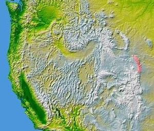
Laramie Mountains
Encyclopedia
Mountain range
A mountain range is a single, large mass consisting of a succession of mountains or narrowly spaced mountain ridges, with or without peaks, closely related in position, direction, formation, and age; a component part of a mountain system or of a mountain chain...
of moderately high peaks on the eastern edge of the Rocky Mountains
Rocky Mountains
The Rocky Mountains are a major mountain range in western North America. The Rocky Mountains stretch more than from the northernmost part of British Columbia, in western Canada, to New Mexico, in the southwestern United States...
in the U.S states
U.S. state
A U.S. state is any one of the 50 federated states of the United States of America that share sovereignty with the federal government. Because of this shared sovereignty, an American is a citizen both of the federal entity and of his or her state of domicile. Four states use the official title of...
of Wyoming
Wyoming
Wyoming is a state in the mountain region of the Western United States. The western two thirds of the state is covered mostly with the mountain ranges and rangelands in the foothills of the Eastern Rocky Mountains, while the eastern third of the state is high elevation prairie known as the High...
and Colorado
Colorado
Colorado is a U.S. state that encompasses much of the Rocky Mountains as well as the northeastern portion of the Colorado Plateau and the western edge of the Great Plains...
. The range is the northernmost extension of the line of the ranges along the eastern side of the Rockies, and in particular of the higher peaks of the Front Range
Front Range
The Front Range is a mountain range of the Southern Rocky Mountains of North America located in the north-central portion of the U.S. State of Colorado and southeastern portion of the U.S. State of Wyoming. It is the first mountain range encountered moving west along the 40th parallel north across...
directly to the south. North of the range, the gap between the Laramie range and the Bighorn Mountains provided the route for historical trails, such as the Oregon Trail
Oregon Trail
The Oregon Trail is a historic east-west wagon route that connected the Missouri River to valleys in Oregon and locations in between.After 1840 steam-powered riverboats and steamboats traversing up and down the Ohio, Mississippi and Missouri rivers sped settlement and development in the flat...
, the Mormon Trail
Mormon Trail
The Mormon Trail or Mormon Pioneer Trail is the 1,300 mile route that members of The Church of Jesus Christ of Latter-day Saints traveled from 1846 to 1868...
, and the Pony Express
Pony Express
The Pony Express was a fast mail service crossing the Great Plains, the Rocky Mountains, and the High Sierra from St. Joseph, Missouri, to Sacramento, California, from April 3, 1860 to October 1861...
.
The mountains extend northward from southeastern Wyoming between Cheyenne
Cheyenne, Wyoming
Cheyenne is the capital and most populous city of the U.S. state of Wyoming and the county seat of Laramie County. It is the principal city of the Cheyenne, Wyoming, Metropolitan Statistical Area which encompasses all of Laramie County. The population is 59,466 at the 2010 census. Cheyenne is the...
and Laramie
Laramie, Wyoming
Laramie is a city in and the county seat of Albany County, Wyoming, United States. The population was 30,816 at the . Located on the Laramie River in southeastern Wyoming, the city is west of Cheyenne, at the junction of Interstate 80 and U.S. Route 287....
, to Casper
Casper, Wyoming
Casper is the county seat of Natrona County, Wyoming, United States.. Casper is the second-largest city in Wyoming , according to the 2010 census, with a population of 55,316...
. They are named after the Laramie River
Laramie River
The Laramie River is a tributary of the North Platte River, approximately long, in the U.S. states of Colorado and Wyoming.It rises in northern Colorado, in the Roosevelt National Forest in the Front Range, in western Larimer County...
, which cuts through the range from southwest to northeast and joins the North Platte River
North Platte River
The North Platte River is a major tributary of the Platte River and is approximately long counting its many curves, It travels about distance. Its course lies in the U.S...
east of the range in eastern Wyoming. The mountains in turn give their name to the Laramide orogeny
Laramide orogeny
The Laramide orogeny was a period of mountain building in western North America, which started in the Late Cretaceous, 70 to 80 million years ago, and ended 35 to 55 million years ago. The exact duration and ages of beginning and end of the orogeny are in dispute, as is the cause. The Laramide...
, the uplift of the North American Plate
North American Plate
The North American Plate is a tectonic plate covering most of North America, Greenland, Cuba, Bahamas, and parts of Siberia, Japan and Iceland. It extends eastward to the Mid-Atlantic Ridge and westward to the Chersky Range in eastern Siberia. The plate includes both continental and oceanic crust...
approximately 70 million years ago that created the present Rocky Mountains.
Geology
The mountains consist of a series of PrecambrianPrecambrian
The Precambrian is the name which describes the large span of time in Earth's history before the current Phanerozoic Eon, and is a Supereon divided into several eons of the geologic time scale...
Sherman granite
Granite
Granite is a common and widely occurring type of intrusive, felsic, igneous rock. Granite usually has a medium- to coarse-grained texture. Occasionally some individual crystals are larger than the groundmass, in which case the texture is known as porphyritic. A granitic rock with a porphyritic...
monadnock
Monadnock
A monadnock or inselberg is an isolated rock hill, knob, ridge, or small mountain that rises abruptly from a gently sloping or virtually level surrounding plain...
s rising above a broad erosion surface that form extensive unwooded parks whose surfaces are generally at about 7000 feet (2,133.6 m) above sea level. The high peaks of the range, which are much lower than those commonly associated with the Rocky Mountains, rise abruptly above the surrounding peneplain
Peneplain
A peneplain is a low-relief plain representing the final stage of fluvial erosion during times of extended tectonic stability. The existence of peneplains, and peneplanation as a geomorphological process, is not without controversy, due to a lack of contemporary examples and uncertainty in...
to altitudes between 8000 feet (2,438.4 m) and 9500 feet (2,895.6 m) above sea level, with the single exception of Laramie Peak which tops out at 10274 feet (3,131.5 m). The granitic soils were formed from the erosion of the surrounding monadnocks and have an effective depth of less than 12 inches (30.5 cm).
Three principal Life Zones are represented in the Laramies: Upper Sonoran, Transition and Canadian. Some early sources indicated that the Hudsonian Zone occurs on Laramie Peak but there is nothing distinctive about either the flora or fauna on the top of this peak, for it consists of nothing but a large granite outcrop. On the eastern and north eastern slopes of the range the prairie/mountain transition is very gentle at the south end (between Cheyenne and Laramie) and much more abrupt and broken farther north. The elevation ranges from about 4500 feet (1,371.6 m) (1370 m) along the North Platte River
North Platte River
The North Platte River is a major tributary of the Platte River and is approximately long counting its many curves, It travels about distance. Its course lies in the U.S...
to 11007 feet (3,354.9 m) at the top of South Bald Mountain
South Bald Mountain
South Bald Mountain, elevation , is the highest point in the Laramie Mountains. The summit in Roosevelt National Forest southwest of Red Feather Lakes is the highest of five peaks forming Bald Mountain....
. On the western slopes the total relief is much less, as the floors of the three intermontane
Intermontane
Intermontane is a physiographic adjective formed from the prefix "inter-" and the adjective "montane" Usage includes intermontane basin such as New Zealand's Mackenzie Basin and intermontane...
basins
Sedimentary basin
The term sedimentary basin is used to refer to any geographical feature exhibiting subsidence and consequent infilling by sedimentation. As the sediments are buried, they are subjected to increasing pressure and begin the process of lithification...
that border the Laramies on this side (Shirley, Hanna and Laramie basins) rarely drop below 7000 feet (2,133.6 m). An extensive high plain and semi-desert extends from the Laramie Mountains south west as far as the Shirley Mountains. The Laramie Basin separates the Laramie Mountains from the Medicine Bow Mountains
Medicine Bow Mountains
The Medicine Bow Mountains are a mountain range in the Rocky Mountains that extend for from northern Colorado into southern Wyoming. The northern extent of this range is the sub-range the Snowy Range...
to the south and west, and its floor is above 7000 feet (2,133.6 m) except for a few depressions and blowout
Blowout (geology)
Blowouts are sandy depressions in a sand dune ecosystem caused by the removal of sediments by wind.Blowouts occur in partially vegetated dunefields or sandhills. A blowout forms when a patch of protective vegetation is lost, allowing strong winds to "blow out" sand and form a depression...
s (such as Cooper Lake).
The Laramie Mountains are bisected by the Laramie River
Laramie River
The Laramie River is a tributary of the North Platte River, approximately long, in the U.S. states of Colorado and Wyoming.It rises in northern Colorado, in the Roosevelt National Forest in the Front Range, in western Larimer County...
, which cuts a canyon through the mountains roughly due west of Wheatland
Wheatland, Wyoming
Wheatland is a town in and the county seat of Platte County in southeastern Wyoming, United States. The population was 3,548 at the 2000 census.-Geography:Wheatland is located at ....
, and then continues its generally eastward course to join the North Platte River
North Platte River
The North Platte River is a major tributary of the Platte River and is approximately long counting its many curves, It travels about distance. Its course lies in the U.S...
near the town of Fort Laramie. The division marks the southern end of the continuous coniferous forest in the range, and separates the range into two parts. The southern part is generally drier and much more open, with little or no forest except for the southern end at Pole Mountain and surrounding area, where the interesting granite outcrops at Vedauwoo
Vedauwoo
Vedauwoo is an area of rocky outcrops located in south-eastern Wyoming, United States, north of Interstate 80, between Laramie and Cheyenne. Its name is an anglicized version of the Arapaho word "bito'o'wu" meaning "earth-born"...
provide climbing practice and grand picnic scenery.
The range is prominently visible from Interstate 25
Interstate 25
Interstate 25 is an Interstate Highway in the western United States. It is primarily a north–south highway. I-25 stretches from Interstate 10 at Las Cruces, New Mexico, , to Interstate 90 in Buffalo, Wyoming, .Interstate 25 is the main north–south expressway through...
between Casper and Cheyenne. Interstate 80
Interstate 80
Interstate 80 is the second-longest Interstate Highway in the United States, following Interstate 90. It is a transcontinental artery running from downtown San Francisco, California to Teaneck, New Jersey in the New York City Metropolitan Area...
and the Union Pacific Railroad
Union Pacific Railroad
The Union Pacific Railroad , headquartered in Omaha, Nebraska, is the largest railroad network in the United States. James R. Young is president, CEO and Chairman....
cross the range between Cheyenne and Laramie on an outlying ramp of the High Plains called the "Gangplank".41°05′56"N 105°06′46"W
See also
- Geography of ColoradoGeography of ColoradoThe geography of the state of Colorado is diverse, encompassing both rugged mountainous terrain, vast plains, desert lands, desert canyons, and mesas. The state of Colorado is defined as the geospherical rectangle that stretches from 37°N to 41°N latitude and from 102°03'W to 109°03'W longitude . ...
- Mountain peaks of ColoradoMountain peaks of ColoradoThis article comprises three sortable tables of the major mountain peaks of the U.S. State of Colorado.Topographic elevation is the vertical distance above the reference geoid, a precise mathematical model of the Earth's sea level as an equipotential gravitational surface...
- Mountain ranges of ColoradoMountain ranges of ColoradoThe following table lists the major mountain ranges of the U.S. State of Colorado.-Mountain Ranges:-See also:*4000 meter peaks of Colorado*Colorado mountain passes*Geography of Colorado*Lists of mountains*Mountain peaks of Colorado...
- Rocky MountainsRocky MountainsThe Rocky Mountains are a major mountain range in western North America. The Rocky Mountains stretch more than from the northernmost part of British Columbia, in western Canada, to New Mexico, in the southwestern United States...
- State of Colorado
- State of Wyoming
Further reading
- Blackstone, D. L. 1971. Traveler's guide to the geology of Wyoming. Bulletin of the Geological Survey of Wyoming. 55:1-90.
- Cary, M., 1917. Life zone investigations in Wyoming. Bulletin USDA Biological Survey. 42: 1-95.
- Dunbar, C. O. 1960. Historical Geology. J. Wiley & Sons, NY. 2nd Ed., fig. 308.
- Hardesty, Richard L. and Groothuis, Dennis R. Butterflies of the Laramie Mountains, Wyoming (Lepidoptera: Rhopalocera.) The introduction provides additional information on the Laramie Mountains. A PDF version of this work may be downloaded at Butterflies of the Laramie Mountains, Wyoming (Lepidoptera: Rhopalocera.).
- Marshall, K. & Colbert, E. H. 1965. Stratigraphy and Life History. J. Wiley & Sons, NY.
- Porter, C. L. 1962. A flora of Wyoming. Part I. Bulletin of the University of Wyoming Agricultural Experimental Station. 402.