
Lake of the Ozarks
Encyclopedia
The Lake of the Ozarks is a large reservoir
created by impounding the Osage River
in the northern part of the Ozarks
in central Missouri
. Extents of three smaller tributaries to the Osage, the Niangua River
, Grandglaize Creek
, and Gravois Creek, are included in the impoundment. The lake has a surface area of 55,000 acres (223 km²), over 1150 miles (1,850.7 km) of shoreline, and the main channel of the Osage Arm stretches 92 miles (148 km) from end to end. The total drainage area is over 14000 square miles (36,259.8 km²). The lake's serpentine shape has earned it the nickname "The Magic Dragon," which has in turn inspired the names of local institutions such as The Magic Dragon Street Meet.
was first pursued by Kansas City
developer Ralph Street in 1912. Street put together the initial funding and began building roads, railroads and infrastructure necessary to begin construction of the dam, with a plan to impound a much smaller lake. In the mid-1920s, Street’s funding dried up and he abandoned the effort.
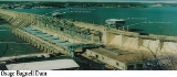
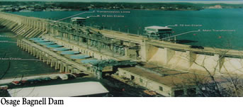 The lake was created by the construction of the 2543 feet (775.1 m) long Bagnell Dam
by Union Electric Company
of St. Louis, Missouri
. The principal engineering firm was Stone and Webster. Construction began August 6, 1929, and was completed in April 1931. The dam is operated and maintained by AmerenUE, the successor of Union Electric, under the authority of a permit issued by the Federal Energy Regulatory Commission
. The Lake of the Ozarks measures more than 90 miles (144.8 km) in length and has several tributaries supplying it. In total, it has over 1100 miles (1,770.3 km) of shoreline in four different Missouri counties. The massive body of water backed up behind Bagnell Dam is the largest manmade lake in the Midwestern United States
.
During construction the lake was referred to as Osage Reservoir or Lake Osage. The Missouri General Assembly
officially named it Lake Benton after the former Senator Thomas Hart Benton
. None of the names took as it was popularly referred to by its location in the Ozarks
. The electric generating station, however, is still referred to by the utility company as the "Osage Hydroelectric Plant."
At the time of construction it was one of the largest man-made lakes in the world and the largest in the United States
. Though built to provide hydroelectric power for customers of Union Electric, the lake quickly became a significant tourist destination for the Midwest. There are over 70,000 homes existing along the lake, many of which are vacation homes. Spectacular scenery characteristic of the Ozarks has also helped to transform the lake into a major resort area. More than 3 million people visit the lake annually.
The Lake of the Ozarks is unique in the fact that it is the largest man-made, non-flood control lake in the United States. The lake rarely varies in surface elevation by more than 5 feet (2 m), with normal pool elevation of 660 feet (201.2 m) above mean sea level. Unlike many flood-control lakes constructed by the Corps of Engineers
, most of the shoreline on the Lake of the Ozarks is privately owned, and the relatively stable surface elevation has created ideal conditions for private development within a few feet of the shoreline.
design occupies raised fingers of land that jut into the lake. Signature par-three 13th calls for a long carry over a cove to reach the green. One of the Midwest's prettiest, most challenging courses.
Osage National Golf Club. This Arnold Palmer
layout is a big-time test(7,150 yards from tips) nestled between Lake of the Ozarks and imposing bluffs of Osage River
. Creeks, lakes, and large, undulating bentgrass greens defend par.
 During the process of land acquisition for the lake during the 1920s, 17500 acres (71 km²) of land along the Grand Glaize Arm of the lake was set aside for a national park. In 1946, this land was acquired by the State of Missouri for Lake of the Ozarks State Park
, the largest State Park in Missouri.
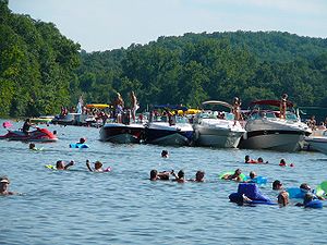
Lake of the Ozarks State Park is home to Party Cove
, a rowdy gathering spot that a travel writer for The New York Times
called the "oldest established permanent floating bacchanal in the country." The Missouri State Water Patrol has estimated that the cove
attracts up to 3000 boats during the Fourth of July weekend.
Another state park on the shores of the lake is Ha Ha Tonka State Park
on the Niangua Arm
of the lake.
, Lake Ozark
, Camdenton
, Gravois Mills
, Sunrise Beach
, Laurie
, Versailles
, Eldon
, Hurricane Deck
, Climax Springs
, and Stover
.
(FERC), in the process of renewing the lease for the power plant operated by Ameron, determined that numerous homes and structures were encroaching on utility land in violation of federal regulations. This issue "has triggered panic in the area's lakefront communities and led to a growing battle among regulators, a utility company, land attorneys and the state's congressional delegation."
Reservoir
A reservoir , artificial lake or dam is used to store water.Reservoirs may be created in river valleys by the construction of a dam or may be built by excavation in the ground or by conventional construction techniques such as brickwork or cast concrete.The term reservoir may also be used to...
created by impounding the Osage River
Osage River
The Osage River is a tributary of the Missouri River in central Missouri in the United States. The Osage River is one of the larger rivers in Missouri. The river drains a mostly rural area of . The watershed includes an area of east-central Kansas and a large portion of west-central and central...
in the northern part of the Ozarks
The Ozarks
The Ozarks are a physiographic and geologic highland region of the central United States. It covers much of the southern half of Missouri and an extensive portion of northwestern and north central Arkansas...
in central Missouri
Missouri
Missouri is a US state located in the Midwestern United States, bordered by Iowa, Illinois, Kentucky, Tennessee, Arkansas, Oklahoma, Kansas and Nebraska. With a 2010 population of 5,988,927, Missouri is the 18th most populous state in the nation and the fifth most populous in the Midwest. It...
. Extents of three smaller tributaries to the Osage, the Niangua River
Niangua River
The Niangua River is a tributary of the Osage River in the Ozarks region of southern and central Missouri in the United States. Via the Osage and Missouri rivers it is part of the watershed of the Mississippi River.-Course:...
, Grandglaize Creek
Grandglaize Creek
Grandglaize Creek is a creek and tributary to the Osage River that forms the Grand Glaize Arm of the Lake of the Ozarks in Missouri. The creek flows for before reaching the Lake of the Ozarks, and the Grand Glaize Arm extends another before reaching the Osage River within the lake.The creek as...
, and Gravois Creek, are included in the impoundment. The lake has a surface area of 55,000 acres (223 km²), over 1150 miles (1,850.7 km) of shoreline, and the main channel of the Osage Arm stretches 92 miles (148 km) from end to end. The total drainage area is over 14000 square miles (36,259.8 km²). The lake's serpentine shape has earned it the nickname "The Magic Dragon," which has in turn inspired the names of local institutions such as The Magic Dragon Street Meet.
History
A hydro-electric power plant on the Osage RiverOsage River
The Osage River is a tributary of the Missouri River in central Missouri in the United States. The Osage River is one of the larger rivers in Missouri. The river drains a mostly rural area of . The watershed includes an area of east-central Kansas and a large portion of west-central and central...
was first pursued by Kansas City
Kansas City, Missouri
Kansas City, Missouri is the largest city in the U.S. state of Missouri and is the anchor city of the Kansas City Metropolitan Area, the second largest metropolitan area in Missouri. It encompasses in parts of Jackson, Clay, Cass, and Platte counties...
developer Ralph Street in 1912. Street put together the initial funding and began building roads, railroads and infrastructure necessary to begin construction of the dam, with a plan to impound a much smaller lake. In the mid-1920s, Street’s funding dried up and he abandoned the effort.
Bagnell Dam
Bagnell Dam impounds the Osage River in the U.S. state of Missouri, creating the Lake of the Ozarks. The 148-foot tall concrete gravity dam was built by the Union Electric Company for the purpose of hydroelectric power generation as its Osage Powerplant. It is long, including a long spillway...
by Union Electric Company
Union Electric Company
The Union Electric Company of Missouri was an electric power utility first organized in 1902. As one of the S&P 500 largest companies in the United States, in 1997 its holding company merged with a smaller neighboring utility, Central Illinois Public Service Company through its holding company,...
of St. Louis, Missouri
St. Louis, Missouri
St. Louis is an independent city on the eastern border of Missouri, United States. With a population of 319,294, it was the 58th-largest U.S. city at the 2010 U.S. Census. The Greater St...
. The principal engineering firm was Stone and Webster. Construction began August 6, 1929, and was completed in April 1931. The dam is operated and maintained by AmerenUE, the successor of Union Electric, under the authority of a permit issued by the Federal Energy Regulatory Commission
Federal Energy Regulatory Commission
The Federal Energy Regulatory Commission is the United States federal agency with jurisdiction over interstate electricity sales, wholesale electric rates, hydroelectric licensing, natural gas pricing, and oil pipeline rates...
. The Lake of the Ozarks measures more than 90 miles (144.8 km) in length and has several tributaries supplying it. In total, it has over 1100 miles (1,770.3 km) of shoreline in four different Missouri counties. The massive body of water backed up behind Bagnell Dam is the largest manmade lake in the Midwestern United States
Midwestern United States
The Midwestern United States is one of the four U.S. geographic regions defined by the United States Census Bureau, providing an official definition of the American Midwest....
.
During construction the lake was referred to as Osage Reservoir or Lake Osage. The Missouri General Assembly
Missouri General Assembly
The Missouri General Assembly is the state legislature of the U.S. state of Missouri. The bicameral General Assembly is composed of a 34-member Senate, and a 163-member House of Representatives. Members of both houses of the General Assembly are subject to term limits...
officially named it Lake Benton after the former Senator Thomas Hart Benton
Thomas Hart Benton (senator)
Thomas Hart Benton , nicknamed "Old Bullion", was a U.S. Senator from Missouri and a staunch advocate of westward expansion of the United States. He served in the Senate from 1821 to 1851, becoming the first member of that body to serve five terms...
. None of the names took as it was popularly referred to by its location in the Ozarks
The Ozarks
The Ozarks are a physiographic and geologic highland region of the central United States. It covers much of the southern half of Missouri and an extensive portion of northwestern and north central Arkansas...
. The electric generating station, however, is still referred to by the utility company as the "Osage Hydroelectric Plant."
At the time of construction it was one of the largest man-made lakes in the world and the largest in the United States
United States
The United States of America is a federal constitutional republic comprising fifty states and a federal district...
. Though built to provide hydroelectric power for customers of Union Electric, the lake quickly became a significant tourist destination for the Midwest. There are over 70,000 homes existing along the lake, many of which are vacation homes. Spectacular scenery characteristic of the Ozarks has also helped to transform the lake into a major resort area. More than 3 million people visit the lake annually.
The Lake of the Ozarks is unique in the fact that it is the largest man-made, non-flood control lake in the United States. The lake rarely varies in surface elevation by more than 5 feet (2 m), with normal pool elevation of 660 feet (201.2 m) above mean sea level. Unlike many flood-control lakes constructed by the Corps of Engineers
United States Army Corps of Engineers
The United States Army Corps of Engineers is a federal agency and a major Army command made up of some 38,000 civilian and military personnel, making it the world's largest public engineering, design and construction management agency...
, most of the shoreline on the Lake of the Ozarks is privately owned, and the relatively stable surface elevation has created ideal conditions for private development within a few feet of the shoreline.
Golf
The Lodge of Four Seasons(Championship Course). Classic Robert Trent JonesRobert Trent Jones
Robert Trent Jones, Sr. was a golf course architect who designed about 500 golf courses in at least 40 US states and 35 other countries all around the world...
design occupies raised fingers of land that jut into the lake. Signature par-three 13th calls for a long carry over a cove to reach the green. One of the Midwest's prettiest, most challenging courses.
Osage National Golf Club. This Arnold Palmer
Arnold Palmer
Arnold Daniel Palmer is an American professional golfer, who is generally regarded as one of the greatest players in the history of men's professional golf. He has won numerous events on both the PGA Tour and Champions Tour, dating back to 1955...
layout is a big-time test(7,150 yards from tips) nestled between Lake of the Ozarks and imposing bluffs of Osage River
Osage River
The Osage River is a tributary of the Missouri River in central Missouri in the United States. The Osage River is one of the larger rivers in Missouri. The river drains a mostly rural area of . The watershed includes an area of east-central Kansas and a large portion of west-central and central...
. Creeks, lakes, and large, undulating bentgrass greens defend par.
Missouri State Parks
Lake of the Ozarks State Park
Lake of the Ozarks State Park is a park on the Grand Glaize Arm of the Lake of the Ozarks and is the largest state park in Missouri.Originally owned by the United States National Park Service as part of the Recreational Demonstration Areas when the lake was built in the 1930s it was donated to the...
, the largest State Park in Missouri.
Lake of the Ozarks State Park is home to Party Cove
Party Cove
Party Cove is the popular name given for Anderson Hollow Cove, a cove in Lake of the Ozarks in Missouri that according to The New York Times is the “oldest established permanent floating bacchanal in the country."...
, a rowdy gathering spot that a travel writer for The New York Times
The New York Times
The New York Times is an American daily newspaper founded and continuously published in New York City since 1851. The New York Times has won 106 Pulitzer Prizes, the most of any news organization...
called the "oldest established permanent floating bacchanal in the country." The Missouri State Water Patrol has estimated that the cove
Cove
A cove is a small type of bay or coastal inlet. They usually have narrow, restricted entrances, are often circular or oval, and are often inside a larger bay. Small, narrow, sheltered bays, inlets, creeks, or recesses in a coast are often considered coves...
attracts up to 3000 boats during the Fourth of July weekend.
Another state park on the shores of the lake is Ha Ha Tonka State Park
Ha Ha Tonka State Park
Ha Ha Tonka State Park is a state park in Missouri, United States, located near Camdenton on the Niangua arm of the Lake of the Ozarks. The area has several caves, sinkholes, and bluffs overlooking the lake. The most notable feature of the park is the stone ruins of a mansion, called "the...
on the Niangua Arm
Niangua River
The Niangua River is a tributary of the Osage River in the Ozarks region of southern and central Missouri in the United States. Via the Osage and Missouri rivers it is part of the watershed of the Mississippi River.-Course:...
of the lake.
Towns
Towns and communities in the area include Osage BeachOsage Beach, Missouri
Osage Beach is a city in Camden and Miller counties in the U.S. state of Missouri. The population was 3,662 at the 2000 census.-Geography:Osage Beach is located at ....
, Lake Ozark
Lake Ozark, Missouri
-Demographics:As of the census of 2000, there were 1,489 people, 649 households, and 427 families residing in the city. The population density was 211.6 people per square mile . There were 1,143 housing units at an average density of 162.4 per square mile...
, Camdenton
Camdenton, Missouri
Camdenton is a city in Camden County, Missouri, United States. The population was 2,779 at the 2000 census. It is the county seat of Camden County. The city is enveloped by the Lower Niangua arm of the Lake of the Ozarks and serves as a popular trade point for visitors to the...
, Gravois Mills
Gravois Mills, Missouri
Gravois Mills is a village in Morgan County, Missouri, United States. The population was 208 at the 2000 census, at which time it was a town.-Geography:Gravois Mills is located at ....
, Sunrise Beach
Sunrise Beach, Missouri
Sunrise Beach is a village in Camden and Morgan counties in the U.S. state of Missouri. The population was 368 as of the 2000 census.-Geography:Sunrise Beach is located at ....
, Laurie
Laurie, Missouri
Laurie is a village in Morgan County, Missouri, United States. The population was 663 at the 2000 census. It is near Camp Hohn, a Boy Scout reservation.-Geography:Laurie is located at ....
, Versailles
Versailles, Missouri
Versailles is a city in Morgan County, Missouri, United States. According to the 2000 census the population is 2,565. It is the county seat of Morgan County...
, Eldon
Eldon, Missouri
Eldon is a city in Miller County, Missouri, United States. It is thirty miles southwest from Jefferson City. The population was 4,895 at the 2000 census.-Geography:Eldon is located at...
, Hurricane Deck
Hurricane Deck, Missouri
Hurricane Deck is an unincorporated community in Camden County, Missouri, United States, on the Lake of the Ozarks. It is part of the lake's resort area, and according to one source is named for a tornado which struck the area, tornadoes once being called "hurricanes" locally.According to...
, Climax Springs
Climax Springs, Missouri
Climax Springs is a village in Camden County, Missouri, United States. The population was 80 at the 2000 census.- History :A large spring flowing out of the hillside was discovered when A.R. Jackson & W.W. Hockman were traveling from the then county seat of Linn Creek to Edwards, MO. In 1880, Mr....
, and Stover
Stover, Missouri
Stover is a city in Morgan County, Missouri, United States. The population was 968 at the 2000 census.-Geography:Stover is located at .According to the United States Census Bureau, the city has a total area of , all of it land....
.
Bridges
Here is a list of historic bridges that were on the lake.- Grand Glaize BridgeGrand Glaize BridgeThe Grand Glaize Bridge are two girder bridges on U.S. Route 54 over the Grand Glaize Arm of the Lake of the Ozarks between Osage Beach, Missouri and Laguna Beach, Missouri in Camden County, Missouri....
— Replaced by two girder bridges. - Hurricane Deck BridgeHurricane Deck BridgeHurricane Deck Bridge is a truss arch bridge located on Lake of the Ozarks in Camden County, Missouri. It carries Missouri Route 5 across the Osage Arm of the lake. It is perhaps one of the most distinctive features on the lake. It is the only truss-type bridge remaining on the lake...
— Still used and is in good condition. - Niangua BridgeNiangua BridgeThe Niangua Bridge is a truss arch bridge located on Lake of the Ozarks in Camden County, Missouri. It carries Route 5 and Route 7 across the Niangua Arm. The construction was similar to the Hurricane Deck Bridge and the I-35W Bridge....
— Replaced by a girder bridge. - Niangua Arm US 54 BridgeNiangua Arm US 54 BridgeThe Niangua Arm US 54 Bridge was a truss-type bridge located on the Niangua Arm of the Lake of the Ozarks in Camden County, Missouri. It was the first bridge to span the completed Lake of the Ozarks. The bridge was similar to the Grand Glaize Bridge except that the steel framework was located on...
— Replaced by a girder bridge.
FERC Controversy
The Federal Energy Regulatory CommissionFederal Energy Regulatory Commission
The Federal Energy Regulatory Commission is the United States federal agency with jurisdiction over interstate electricity sales, wholesale electric rates, hydroelectric licensing, natural gas pricing, and oil pipeline rates...
(FERC), in the process of renewing the lease for the power plant operated by Ameron, determined that numerous homes and structures were encroaching on utility land in violation of federal regulations. This issue "has triggered panic in the area's lakefront communities and led to a growing battle among regulators, a utility company, land attorneys and the state's congressional delegation."