

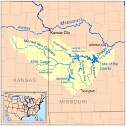
Osage River
Encyclopedia
Missouri River
The Missouri River flows through the central United States, and is a tributary of the Mississippi River. It is the longest river in North America and drains the third largest area, though only the thirteenth largest by discharge. The Missouri's watershed encompasses most of the American Great...
in central Missouri
Missouri
Missouri is a US state located in the Midwestern United States, bordered by Iowa, Illinois, Kentucky, Tennessee, Arkansas, Oklahoma, Kansas and Nebraska. With a 2010 population of 5,988,927, Missouri is the 18th most populous state in the nation and the fifth most populous in the Midwest. It...
in the United States
United States
The United States of America is a federal constitutional republic comprising fifty states and a federal district...
. The Osage River is one of the larger rivers in Missouri. The river drains a mostly rural area of 15300 square miles (39,626.8 km²). The watershed includes an area of east-central Kansas
Kansas
Kansas is a US state located in the Midwestern United States. It is named after the Kansas River which flows through it, which in turn was named after the Kansa Native American tribe, which inhabited the area. The tribe's name is often said to mean "people of the wind" or "people of the south...
and a large portion of west-central and central Missouri where it drains northwest areas of the Ozark Plateau. The river flows generally easterly, then northeasterly for the final 80 miles (128.7 km) where it joins the Missouri River. It is impounded in two major locations. Most of the river has been converted into a chain of two reservoirs, the Harry S. Truman Reservoir and the Lake of the Ozarks
Lake of the Ozarks
The Lake of the Ozarks is a large reservoir created by impounding the Osage River in the northern part of the Ozarks in central Missouri. Extents of three smaller tributaries to the Osage, the Niangua River, Grandglaize Creek, and Gravois Creek, are included in the impoundment...
.
Description
The Osage is formed in southwestern Missouri, approximately 14 miles (22.5 km) northeast of NevadaNevada, Missouri
Nevada is a city in Vernon County, Missouri, United States. The population was 8,327 at the 2011 census. It is the county seat of Vernon County. Nevada is the home of Cottey College, a junior college for women operated by the P.E.O. Sisterhood....
on the Bates
Bates County, Missouri
Bates County is a county located in the U.S. state of Missouri. As of 2000, the population is 16,653. Its county seat is Butler. The county was organized in 1833 and named after Frederick Bates, the second governor of Missouri....
-Vernon county line, by the confluence of the Marais des Cygnes
Marais des Cygnes River
The Marais des Cygnes River is a principal tributary of the Osage River, about long, in eastern Kansas and western Missouri in the United States. Via the Osage and Missouri rivers, it is part of the watershed of the Mississippi River...
and Little Osage
Little Osage River
The Little Osage River is an tributary of the Osage River in eastern Kansas and western Missouri in the United States. Via the Osage and Missouri rivers, it is part of the watershed of the Mississippi River.-Course:...
rivers. (The Marais des Cygnes is sometimes counted as part of the river, placing its headwaters in eastern Kansas
Kansas
Kansas is a US state located in the Midwestern United States. It is named after the Kansas River which flows through it, which in turn was named after the Kansa Native American tribe, which inhabited the area. The tribe's name is often said to mean "people of the wind" or "people of the south...
and bringing its total length to over 500 miles (804.7 km)). The combined stream flows east past the Schell-Osage Wildlife Area into St. Clair County, widening into a long meander
Meander
A meander in general is a bend in a sinuous watercourse. A meander is formed when the moving water in a stream erodes the outer banks and widens its valley. A stream of any volume may assume a meandering course, alternately eroding sediments from the outside of a bend and depositing them on the...
ing arm of the Harry S. Truman Reservoir, approximately 40 miles (64.4 km) long. The lake receives the South Grand River as a second arm of the reservoir from the northwest, as well as the Pomme de Terre River
Pomme de Terre River (Missouri)
The Pomme de Terre River is a tributary of the Osage River in southwestern Missouri in the United States. Via the Osage and Missouri rivers, it is part of the watershed of the Mississippi River.Pomme de terre is French for potato.-Course:...
from the south. The two arms of the reservoir join near the Harry S. Truman Dam in central Benton County.
Downstream from the Truman Dam, the river becomes the serpentine Lake of the Ozarks
Lake of the Ozarks
The Lake of the Ozarks is a large reservoir created by impounding the Osage River in the northern part of the Ozarks in central Missouri. Extents of three smaller tributaries to the Osage, the Niangua River, Grandglaize Creek, and Gravois Creek, are included in the impoundment...
, stretching eastward for nearly 92 miles (148.1 km) to Bagnell Dam
Bagnell Dam
Bagnell Dam impounds the Osage River in the U.S. state of Missouri, creating the Lake of the Ozarks. The 148-foot tall concrete gravity dam was built by the Union Electric Company for the purpose of hydroelectric power generation as its Osage Powerplant. It is long, including a long spillway...
in Camden County
Camden County, Missouri
Camden County is a county located in the U.S. state of Missouri. As of 2000, the population was 37,051. Its county seat is Camdenton. The county was organized in 1841 as Kinderhook County and renamed in 1843, for Charles Pratt, 1st Earl Camden, Chancellor of England, and leader of the Whig...
and southwestern Miller County. Constructed in 1931, it collects the Niangua River
Niangua River
The Niangua River is a tributary of the Osage River in the Ozarks region of southern and central Missouri in the United States. Via the Osage and Missouri rivers it is part of the watershed of the Mississippi River.-Course:...
. Downstream from the dam, the Osage flows freely to the northeast in broad oxbow
Oxbow
An oxbow is a U-shaped wooden or metal frame that fits under and around the neck of an ox or bullock, with its upper ends passing through the bar of the yoke and held in place with a metal key, called a bow pin. The wood most often used is hardwood steamed into shape, like elm or hickory and...
meanders through forested bluffs, joining the Missouri approximately 15 miles (24.1 km) east and downstream of Jefferson City
Jefferson City, Missouri
Jefferson City is the capital of the U.S. state of Missouri and the county seat of Cole County. Located in Callaway and Cole counties, it is the principal city of the Jefferson City metropolitan area, which encompasses the entirety of both counties. As of the 2010 census, the population was 43,079...
.
History
The river is named for the Osage NationOsage Nation
The Osage Nation is a Native American Siouan-language tribe in the United States that originated in the Ohio River valley in present-day Kentucky. After years of war with invading Iroquois, the Osage migrated west of the Mississippi River to their historic lands in present-day Arkansas, Missouri,...
, the indigenous people in area at the time of the arrival of the first Europe
Europe
Europe is, by convention, one of the world's seven continents. Comprising the westernmost peninsula of Eurasia, Europe is generally 'divided' from Asia to its east by the watershed divides of the Ural and Caucasus Mountains, the Ural River, the Caspian and Black Seas, and the waterways connecting...
an settlers. It presented significant navigation difficulties for early settlers because of its fluctuating water levels, as well as the presence of shallow pools and sand bars caused by its tight meandering course through the hills.
The Missouri Legislature attempted as early as 1839 to deepen the channel of the river. Early attempts failed because of lack of funding for the immense task. Commercial navigation on the river in the 19th century was confined mostly to smaller craft that could navigate the tight bends and shoals of the river. Improvements in the channel by the last two decades of the century led to greater commercial traffic. The construction of the Bagnell Dam
Bagnell Dam
Bagnell Dam impounds the Osage River in the U.S. state of Missouri, creating the Lake of the Ozarks. The 148-foot tall concrete gravity dam was built by the Union Electric Company for the purpose of hydroelectric power generation as its Osage Powerplant. It is long, including a long spillway...
, primarily for hydroelectricity
Hydroelectricity
Hydroelectricity is the term referring to electricity generated by hydropower; the production of electrical power through the use of the gravitational force of falling or flowing water. It is the most widely used form of renewable energy...
, commenced in 1922 and was completed after nine years. It effectively ended commercial navigation on the river. The Truman Dam was authorized by the Flood Control Act
Flood Control Act
There are multiple laws known as the Flood Control Act. Typically, they are administered by the United States Army Corps of Engineers:-List of Flood Control Acts:*Flood Control Act of 1917...
of 1954 and completed in 1979.
The two dams on the river currently provide power for the St. Louis
St. Louis, Missouri
St. Louis is an independent city on the eastern border of Missouri, United States. With a population of 319,294, it was the 58th-largest U.S. city at the 2010 U.S. Census. The Greater St...
metropolitan areas. The reservoirs are popular tourist destinations in the region.