
Lady Musgrave Island
Encyclopedia
Lady Musgrave Island is a 14 hectares (34.6 acre) coral
cay
in the Great Barrier Reef
, with a 1192 hectares (2,945.5 acre) surrounding reef. The island is the second island in the Great Barrier Reef chain of islands (with the first being Lady Elliot Island
), and is most easily reached from the town of 1770, Queensland
, located on approximately 5 hours north of Brisbane
. It is named for the wife of Sir Anthony Musgrave
, a colonial governor of Queensland
.
Lady Musgrave Island, and the immediate surrounds, is a national park and can be reached by excursion boat from the Town of 1770. It is also part of the Capricornia Cays Important Bird Area
.
It is recognised that the permitted numbers of visitors on Lady Musgrave Island at this time, have reached (and at times exceeded) an ecologically sustainable level.
This island is the only shingle cay situated on the leeward reef flat. the island also has Beach rock is exposed along the north eastern and eastern beaches and an outcrop of lithified coral conglomerate, similar to that forming the core of the cay, occurs near the south eastern corner.
Vegetation consists of Pisonia grandis
, Tournefortia argentea, Casuarina equisetifolia
, and Pandanus tectorius
. The vegetation is less dense than that of the larger sand cays of the Capricorn Group.
A small pond of brackish water is located towards the southern end of the cay.
The Island is located on the southern end of a large lagoon.
From a boating prospective the great part about Lady Musgrave is you can enter the lagoon via a deep water channel.
There is some connector as to if the channel into the lagoon is a naturally occurring phenomena, or was cut into the lagoon by Japanese’s fisherman, or as legend has it was widened by guano miners many years ago although it is recorded by 1938 and in 1966 surveys.
 A lease for navigation purposes exists on Lady Musgrave Island with a lighthouse was constructed on Lady Musgrave Island in April 1974. The light is controlled and maintained by the Australian Maritime Safety Authority with inspections of the light are undertaken by helicopter, and an area of the lease is set aside for landing purposes. The facility is maintained using an amphibious vehicle launched from a maintenance vessel.
Much of this area comes under the Capricornia Cays National Park
with current usages including camping, permitted on four cays up to the following limits:
The island has no fresh water supply, so visitors need to bring all fresh drinking water. A composting toilet is available on the island.
The area also has many visits by both passing vessels cruising the Queensland coast and day trippers in fast jet catamarans (typically Lady Musgrave Island).
The area is also of significances as a fishery particularly for King Prawns.
of the whaling ship Albion was the first European to discover the region and gave his name to the southern group.
The southern cays and reefs were first charted between 1819 and 1821 by Lieutenant Phillip Parker King Royal Navy initially in the Mermaid and later in the Bathurst. The main charting exercise for all the islands and reefs was carried out in 1843 under the command of Captain Francis Blackwood in HMS Fly
which was accompanied by the Bramble. The naturalist, Professor J. Beete Jukes, was on board the Fly and his published journal provides valuable information on some of the cays.
(bird droppings) occurred on Lady Musgrave Island, Fairfax Islands
and North West Island
during the 1890s. This was an extension of a more substantial guano mining operation on Lady Elliot Island
to the south. Some remains of these activities are still evident.
Lady Elliot Island was the first to be mined in 1893. They took about one metre off the island. The next to be mined was the next island in the chain, Lady Musgrave Island. Although they knew the name, the guano miners called the place Bunker number 1 — Fairfax Islands were known as Bunker number 2. Fairfax was more heavily mined before the miners moved onto North West Island.
An extract from the original miners helps paint the picture of the operations on Lady Musgrave "We had a good run across, and pitched camp a short distance above the crown of the beach, the cutter anchoring in the capacious lagoon. This has the important distinction of having a narrow deep-water entrance, enabling small vessels to enter or leave at any time of the tide. Being narrow it is somewhat difficult to locate. A permanent beacon at each end of the channel would be very useful" ....... On Lady Musgrave "The phosphate-guano deposits proved very meagre. Taking the whale boat we then sailed down to Fairfax Island (Bunker No.2), only: four or five miles distant. Fairfax Island was a difficult place to work, particularly as to the shipping; tide work was necessary and a launch was used for the long tow out to the anchorage. Operations on a minor scale were carried on at Lady Musgrave at the same time, a ketch being employed to lighter cargoes across to the sailing vessels loading at the other island. It was out of the question to use steamers in the trade, the rate of loading being much too low".
The island had been a hub for a number of pleasure cruises when eventually more extensive construction of tourist facilities occurred in 1938 and 1939 at Lady Musgrave Island, including six cottages and other facilities.
The caretakers were Mr & Mrs Bell and they “discourage the removal of marine growth in every way and to assist in this object specimens of the reef life are not even collected for display purposes at the settlement”.
At around this period the Sapphire (photo of the Sapphire) was being used to regularly take tourists from Bundaberg to Lady Musgrave Island. The vessel was owned and operated by Eric Keppel Hansen (he preferred to be called Keppel).
were used as a bombing range by the Royal Australian Air Force
and Royal Australian Navy
from the 1940 through to the 1960s.
It is likely that during World War II Lady Musgrave reef was also used for bombing practice “with the reef now practically a marine desert” as reported in 1952.
to the port of Bluff
, New Zealand
.
The ship become hard fast on the reef in a position with the island's light bearing 075 degrees true distant about 0.35 miles (563.3 m); that the ship's engines continued to run ahead until about 04:00 hours when they were stopped.
The ship suffered extensive bottom damage in the incident. There was no loss of life or injury to persons and no pollution of the marine environment attributable to the incident. The ship was refloated with the aid of a tug on 26 March 1985 and anchored off the island until 29 March for divers' inspection of the damage and temporary repairs. The ship then proceeded under its own power at reduced speed to Newcastle, New South Wales
for assessment of the damage and, subsequently, permanent repairs.
That the grounding was directly caused by the failure of the officer of the watch to control the navigation of the ship over an extended period.
The TNT Alltrans is a diesel engined bulk carrier of 35,218 tonnes deadweight, built in 1983. It carries alumina in bulk, The ship is fitted with cargo-handling equipment which enables it to discharge its own cargoes and has been employed continuously since commissioning in the carriage of alumina from Gladstone to Bluff, and from Bunbury, Western Australia
to Bell Bay, Tasmania
.
) trees are the primary vegetation, with She-Oak
s and Pandanus (Pandanus tectorius
) trees forming most of the remaining percentage.
Camping is allowed for up to 40 people at a time, with some restrictions (e.g.: no open fires), and must be booked. Camping can be booked up to 11 months in advance and is recommended that you do so, especially during school holidays. The island is closed to all campers in the months of February and March to protect turtle hatchlings. More information can be found at https://www.epa.qld.gov.au/parks/iaparks/gds/IAGDS030.do#Lady%20Musgrave%20Island%20campground. Camping permits can be obtained for a small fee online. Campers can bring their own dive compressors (can only be run from 9 am to 6 pm). Generators are NOT allowed.
The daily (subject to weather) tourist boat from 1770 can resupply campers with prearranged supplies.
As the island is well outside the light cone of coastal cities, the stargazing is spectacular, with nightly meteor showers not uncommon.
The extreme edges of the coral
lagoon
should generally be avoided during tidal inflow and outflow, as the pull can be quite strong. There is an old legend involving a legless man and a widow who died there. It is rumored to be haunted by their ghosts.
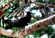 There are an enormous number of birds on the island. White-capped Noddy Tern
s nest in abundance in the Pisonia trees whilst Bridled Terns, Black-naped Terns and Silver Gulls nest on the ground in more open areas nearer the beach. The carcasses of Noddy Tern chicks that fall out of nests or adults that become tangled in the sticky Pisonia seeds are quickly devoured by centipedes and the nutrients eventually returned to the soil. From December to May, migratory Wedge-tailed Shearwater
s, colloquially known as 'mutton birds', nest in burrows in the interior of the island and their mournful wails can be heard at night. These birds are readily seen along the forest walk at night and precaution must be taken to not stray from the path as the burrows easily collapse under the weight of a person. From September to March, migratory shorebirds such as Ruddy Turnstone, Grey-tailed Tattler, Wandering Tattler, Bar-tailed Godwit, Pacific Golden Plover and Lesser Sand Plover can be seen foraging on the reef flat at low tide. Buff-banded Rail
s, white and grey phases of the Eastern Reef Egret
, Pied Oystercatchers, Sooty Oystercatchers and Capricorn Silvereye
s are resident on the island year-round.
The island is a nesting place for Green and Loggerhead turtles, and there is usually a turtle-research representative camping on the island during nesting and hatching times.
Small Whitetip reef shark
s and Leopard sharks can often be found hunting in the shallows around the island. These species are not dangerous to humans, and are fascinating to watch.
Green and leatherback turtles can be spotted resting on coral bommies, and the coral lagoon is a haven for a multitude of fish and coral species, and a spectacular destination for anyone interested in snorkeling.
Over a period of time the vegetation suffered and damage was caused on the island from over-grazing by goats, as on many islands in the Great Barrier Reef.
In particular, the destruction of vegetation at Lady Musgrave Island has been documented since 1928, when Napier provided the following account:
This account was corroborated by another, written in 1936 by the Queensland Acting Director of Forests, who stated that at Lady Musgrave and nearby islands the presence of large herds of goats was threatening both the ‘scenic charm’ of the islands and the native island wildlife; he stated that grazing by goats resulted in the ‘destruction of the grass, herbaceous and shrubby vegetation on the islands [and the] diminution of the normal food for land birds and other Australian animals.
Also in 1936, the destruction of vegetation at Lady Musgrave Island and other islands of the Capricorn-Bunker Group was described by NP Ranger G. Geoffrey, who reported the presence of ‘about 20 head of goats’ at Lady Musgrave Island, herds of goats in the Bunker Group, and about ‘150 head of goats’ at North Fairfax Island, which were reported to be in very poor condition as a result of lack of food and were eating the roots of Pisonia trees in order to survive.
By 1947, the destruction of the island vegetation by goats was still occurring. Mr Marshall, the Queensland Ichthyologist, stated that ‘at present the above island has become over-run with goats. They have eaten the island bare of grass and are now destroying trees.’ In 1948, an early attempt to eradicate goats from Lady Musgrave Island was made and a NP Ranger reported that all goats on that island were removed and destroyed, although goats were subsequently re-introduced.
Further damage was documented at Lady Musgrave Island during the 1960s, including others impact besides the destruction of vegetation. In 1964, although the goat population had declined to around 18 animals, many ticks were found at the island.
While still unsatisfactory because of the destruction of vegetation it was still an improvement since the almost complete destruction of the vegetation, in 1927, by around 200–300 goats.
One reason why the eradication of goats was difficult to accomplish was the deliberate transfer of some animals between islands, as Julie Booth, a naturalist resident on Fairfax Island, reported in 1969. She stated: ‘there have been a large number of campers at Lady Musgrave who visited Fairfax […]. [They] brought two goats over from the other island, which they were going to leave here.’
Goat were eradicated 1974 on Lady Musgrave with approximately 300 removed by hunting.
Vegetation has recovered since 1974.
. Departed from Sydney with general cargo for Broadsound; and ran aground on Lady Musgrave Is; maybe on Heron Is or One Tree Island or Masthead Reef Lost on a reef off Heron Island on the night of 17 December 1868. The crew took to the boat and safely reached the Pilot Station at Keppel Island.
The vessel was originally stated as having hit at Lady Musgrave reef (most unlikely) later news reports claim wreck on Heron Island with some other reports mention the wreck on either One Tree Island or Mast Head.
The vessel was built in 1861 at Ulladulla New South Wales and registered in Sydney with the Official number of 36858 and a Registered number of 9/1861 with a gross tonnage of 80 tons and 82 feet in length.
From the original reports
and 6 months latter it was reported as
Bannockburn A 85 feet long, 110 ton, Brigantine built at Mechanic's Bay, Auckland in 1880 on the 9th November 1884 struck no.1 Bunker Island and was refloated after cargo (timber) salvaged, taken to Rockhampton. Eventually became a total loss due wrecking in Fitzroy River 1905.
Kokotu Motor Vessel Struck a reef off Lady Musgrave Island during cyclone Emily, 1 April 1972.
Still to track down additional info
Plane wreck see dive oz
I think the aircraft that Leod is referring could be a float plane that had a somersault on landing just near the island, though I don't know if this was inside the lagoon or not. This would have been about 10 years ago now, maybe 8, we were anchored there the day before it happened, it was crappy weather.They pretty much stopped using float planes to Musgrave after that, though I guess a plane crash would ruin any business. Its quite possible that it broke into bits in the subsequent weather and what you found are the remnants. There are also some remains of a yacht to the left of the lagoon entrance [if you're on the outside looking in] a couple of hundred metres.
Fishing Trawler on or around Christmas 1990/91 fire and sank in Nor East corner of lagoon.
Coral
Corals are marine animals in class Anthozoa of phylum Cnidaria typically living in compact colonies of many identical individual "polyps". The group includes the important reef builders that inhabit tropical oceans and secrete calcium carbonate to form a hard skeleton.A coral "head" is a colony of...
cay
Cay
A cay , also spelled caye or key, is a small, low-elevation, sandy island formed on the surface of coral reefs. Cays occur in tropical environments throughout the Pacific, Atlantic and Indian Oceans , where they provide habitable and agricultural land for hundreds of thousands of people...
in the Great Barrier Reef
Great Barrier Reef
The Great Barrier Reef is the world'slargest reef system composed of over 2,900 individual reefs and 900 islands stretching for over 2,600 kilometres over an area of approximately...
, with a 1192 hectares (2,945.5 acre) surrounding reef. The island is the second island in the Great Barrier Reef chain of islands (with the first being Lady Elliot Island
Lady Elliot Island
Lady Elliot Island is the southern-most coral cay of the Great Barrier Reef, Australia. The island lies north-east of Bundaberg and covers an area of approximately . The island is home to a small eco resort and an airstrip, which is serviced daily by flights from Bundaberg, Hervey Bay,...
), and is most easily reached from the town of 1770, Queensland
1770, Queensland
1770 is a village in Queensland, Australia, built on the site of the second landing by James Cook and the crew of HM Bark Endeavour in May 1770 . Originally known as Round Hill — after the creek it sits on — the name was changed in 1970 to commemorate the bicentennial of Cook's visit...
, located on approximately 5 hours north of Brisbane
Brisbane
Brisbane is the capital and most populous city in the Australian state of Queensland and the third most populous city in Australia. Brisbane's metropolitan area has a population of over 2 million, and the South East Queensland urban conurbation, centred around Brisbane, encompasses a population of...
. It is named for the wife of Sir Anthony Musgrave
Anthony Musgrave
Sir Anthony Musgrave KCMG was a colonial administrator and governor. He was born at St John’s, Antigua, the third of 11 children of Anthony Musgrave and Mary Harris Sheriff...
, a colonial governor of Queensland
Queensland
Queensland is a state of Australia, occupying the north-eastern section of the mainland continent. It is bordered by the Northern Territory, South Australia and New South Wales to the west, south-west and south respectively. To the east, Queensland is bordered by the Coral Sea and Pacific Ocean...
.
Lady Musgrave Island, and the immediate surrounds, is a national park and can be reached by excursion boat from the Town of 1770. It is also part of the Capricornia Cays Important Bird Area
Important Bird Area
An Important Bird Area is an area recognized as being globally important habitat for the conservation of bird populations. Currently there are about 10,000 IBAs worldwide. The program was developed and sites are identified by BirdLife International...
.
General
Lady Musgrave Island is the most intensively used of the camping islands within the Capricorn Bunker group, due to its protected anchorage within a semi-enclosed lagoon and a regular ferry service. More than 10,000 day-visitors were brought to the island by commercial tourism operators during 1997. In addition, 1,278 campers visited the island for 8,008 camper nights and there were an estimated 5840 visitors from recreational boats during that year.It is recognised that the permitted numbers of visitors on Lady Musgrave Island at this time, have reached (and at times exceeded) an ecologically sustainable level.
This island is the only shingle cay situated on the leeward reef flat. the island also has Beach rock is exposed along the north eastern and eastern beaches and an outcrop of lithified coral conglomerate, similar to that forming the core of the cay, occurs near the south eastern corner.
Vegetation consists of Pisonia grandis
Pisonia grandis
Pisonia grandis is a species of flowering tree in the Bougainvillea family, Nyctaginaceae.-Description:The tree has broad, thin leaves, smooth bark and bears clusters of green sweet-smelling flowers that mature into sticky barbed seeds....
, Tournefortia argentea, Casuarina equisetifolia
Casuarina equisetifolia
Casuarina equisetifolia is a she-oak species of the genus Casuarina. The native range extends from Burma and Vietnam throughout Malesia east to French Polynesia, New Caledonia, and Vanuatu, and south to Australia...
, and Pandanus tectorius
Pandanus tectorius
Pandanus tectorius is a species of Pandanus that is native to Malesia, eastern Australia, and the Pacific Islands. Common names include Thatch Screwpine, Hala , Bacua , and Vacquois ....
. The vegetation is less dense than that of the larger sand cays of the Capricorn Group.
A small pond of brackish water is located towards the southern end of the cay.
The Island is located on the southern end of a large lagoon.
From a boating prospective the great part about Lady Musgrave is you can enter the lagoon via a deep water channel.
There is some connector as to if the channel into the lagoon is a naturally occurring phenomena, or was cut into the lagoon by Japanese’s fisherman, or as legend has it was widened by guano miners many years ago although it is recorded by 1938 and in 1966 surveys.
Current uses
Much of this area comes under the Capricornia Cays National Park
Capricornia Cays National Park
Capricornia Cays is both a national park and a scientific national park in Queensland , located 486 km and 472 km north of the state capital Brisbane respectively. Collectively they comprise 241 ha of coral cays....
with current usages including camping, permitted on four cays up to the following limits:
- North West IslandNorth West IslandNorth West Island is a coral cay in the southern Great Barrier Reef, located 75 kilometres northeast of Gladstone, Queensland. North West Island forms part of Capricornia Cays National Park and with an area of 1.05 km², the island is the second largest coral cay in the Great Barrier Reef...
150 campers - Lady Musgrave Island 40 campers
- Masthead IslandMasthead IslandMasthead Island is a coral cay located in the southern Great Barrier Reef, 60 kilometres northeast of Gladstone, Queensland. The island is a protected area and forms part of Capricornia Cays National Park. Masthead Island is one of the most undisturbed cays in the national park because human and...
60 campers (30 from October to March) - Tryon IslandTryon IslandTryon Island is a coral cay located in the southern Great Barrier Reef, 86 km northeast of Gladstone, Queensland, Australia, and 465 km north of the state capital Brisbane. The island is a protected area and forms part of Capricornia Cays National Park. It is part of the Capricornia Cays...
30 campers. (Currently closed.)
The island has no fresh water supply, so visitors need to bring all fresh drinking water. A composting toilet is available on the island.
The area also has many visits by both passing vessels cruising the Queensland coast and day trippers in fast jet catamarans (typically Lady Musgrave Island).
The area is also of significances as a fishery particularly for King Prawns.
Discovery
In 1803 Captain Eber BunkerEber Bunker
Eber Bunker was a sea captain and pastoralist, born on 7 March 1761 at Plymouth, Massachusetts. His parents were James Bunker and his wife Hannah, née Shurtleff.-1776-1786: Background:...
of the whaling ship Albion was the first European to discover the region and gave his name to the southern group.
The southern cays and reefs were first charted between 1819 and 1821 by Lieutenant Phillip Parker King Royal Navy initially in the Mermaid and later in the Bathurst. The main charting exercise for all the islands and reefs was carried out in 1843 under the command of Captain Francis Blackwood in HMS Fly
HMS Fly (1831)
HMS Fly was an 18-gun sloop of the Royal Navy. She was responsible for the exploration and charting of much of Australia's north-east coast and nearby islands. She was converted to a coal hulk in 1855 and broken up in 1903.-Design and construction:...
which was accompanied by the Bramble. The naturalist, Professor J. Beete Jukes, was on board the Fly and his published journal provides valuable information on some of the cays.
Guano mining in the 1890s
The mining of guanoGuano
Guano is the excrement of seabirds, cave dwelling bats, and seals. Guano manure is an effective fertilizer due to its high levels of phosphorus and nitrogen and also its lack of odor. It was an important source of nitrates for gunpowder...
(bird droppings) occurred on Lady Musgrave Island, Fairfax Islands
Fairfax Islands
Fairfax Islands is a pair of small coral cays, both of which have been used as a bombing range. They are located near the Tropic of Capricorn in the southern Great Barrier Reef, 113 km due east of Gladstone, Queensland, Australia, and 405 km north of the state capital Brisbane.The island...
and North West Island
North West Island
North West Island is a coral cay in the southern Great Barrier Reef, located 75 kilometres northeast of Gladstone, Queensland. North West Island forms part of Capricornia Cays National Park and with an area of 1.05 km², the island is the second largest coral cay in the Great Barrier Reef...
during the 1890s. This was an extension of a more substantial guano mining operation on Lady Elliot Island
Lady Elliot Island
Lady Elliot Island is the southern-most coral cay of the Great Barrier Reef, Australia. The island lies north-east of Bundaberg and covers an area of approximately . The island is home to a small eco resort and an airstrip, which is serviced daily by flights from Bundaberg, Hervey Bay,...
to the south. Some remains of these activities are still evident.
Lady Elliot Island was the first to be mined in 1893. They took about one metre off the island. The next to be mined was the next island in the chain, Lady Musgrave Island. Although they knew the name, the guano miners called the place Bunker number 1 — Fairfax Islands were known as Bunker number 2. Fairfax was more heavily mined before the miners moved onto North West Island.
An extract from the original miners helps paint the picture of the operations on Lady Musgrave "We had a good run across, and pitched camp a short distance above the crown of the beach, the cutter anchoring in the capacious lagoon. This has the important distinction of having a narrow deep-water entrance, enabling small vessels to enter or leave at any time of the tide. Being narrow it is somewhat difficult to locate. A permanent beacon at each end of the channel would be very useful" ....... On Lady Musgrave "The phosphate-guano deposits proved very meagre. Taking the whale boat we then sailed down to Fairfax Island (Bunker No.2), only: four or five miles distant. Fairfax Island was a difficult place to work, particularly as to the shipping; tide work was necessary and a launch was used for the long tow out to the anchorage. Operations on a minor scale were carried on at Lady Musgrave at the same time, a ketch being employed to lighter cargoes across to the sailing vessels loading at the other island. It was out of the question to use steamers in the trade, the rate of loading being much too low".
Tourist resort in the 1930s
A concrete slab is the only remnant of a resort which operated at Lady Musgrave Island during the 1930s.The island had been a hub for a number of pleasure cruises when eventually more extensive construction of tourist facilities occurred in 1938 and 1939 at Lady Musgrave Island, including six cottages and other facilities.
The caretakers were Mr & Mrs Bell and they “discourage the removal of marine growth in every way and to assist in this object specimens of the reef life are not even collected for display purposes at the settlement”.
At around this period the Sapphire (photo of the Sapphire) was being used to regularly take tourists from Bundaberg to Lady Musgrave Island. The vessel was owned and operated by Eric Keppel Hansen (he preferred to be called Keppel).
Military target practice at Fairfax Islands, 1943
East and West Fairfax IslandsFairfax Islands
Fairfax Islands is a pair of small coral cays, both of which have been used as a bombing range. They are located near the Tropic of Capricorn in the southern Great Barrier Reef, 113 km due east of Gladstone, Queensland, Australia, and 405 km north of the state capital Brisbane.The island...
were used as a bombing range by the Royal Australian Air Force
Royal Australian Air Force
The Royal Australian Air Force is the air force branch of the Australian Defence Force. The RAAF was formed in March 1921. It continues the traditions of the Australian Flying Corps , which was formed on 22 October 1912. The RAAF has taken part in many of the 20th century's major conflicts...
and Royal Australian Navy
Royal Australian Navy
The Royal Australian Navy is the naval branch of the Australian Defence Force. Following the Federation of Australia in 1901, the ships and resources of the separate colonial navies were integrated into a national force: the Commonwealth Naval Forces...
from the 1940 through to the 1960s.
It is likely that during World War II Lady Musgrave reef was also used for bombing practice “with the reef now practically a marine desert” as reported in 1952.
TNT Alltrans grounding on 25 March 1985
At about 03:40 on 25 March 1985 the Australian registered ship TNT Alltrans grounded on Lady Musgrave Island, while on a voyage from Gladstone, QueenslandGladstone, Queensland
- Education :Gladstone has several primary schools, three high schools, and one university campus, Central Queensland University. It is also home to CQIT Gladstone Campus.- Recreation :...
to the port of Bluff
Bluff, New Zealand
Bluff is a town and seaport in the Southland region, on the southern coast of the South Island of New Zealand. It is the southern-most town in New Zealand and, despite Slope Point being further to the south, is colloquially used to refer to the southern extremity of the country...
, New Zealand
New Zealand
New Zealand is an island country in the south-western Pacific Ocean comprising two main landmasses and numerous smaller islands. The country is situated some east of Australia across the Tasman Sea, and roughly south of the Pacific island nations of New Caledonia, Fiji, and Tonga...
.
The ship become hard fast on the reef in a position with the island's light bearing 075 degrees true distant about 0.35 miles (563.3 m); that the ship's engines continued to run ahead until about 04:00 hours when they were stopped.
The ship suffered extensive bottom damage in the incident. There was no loss of life or injury to persons and no pollution of the marine environment attributable to the incident. The ship was refloated with the aid of a tug on 26 March 1985 and anchored off the island until 29 March for divers' inspection of the damage and temporary repairs. The ship then proceeded under its own power at reduced speed to Newcastle, New South Wales
Newcastle, New South Wales
The Newcastle metropolitan area is the second most populated area in the Australian state of New South Wales and includes most of the Newcastle and Lake Macquarie Local Government Areas...
for assessment of the damage and, subsequently, permanent repairs.
That the grounding was directly caused by the failure of the officer of the watch to control the navigation of the ship over an extended period.
The TNT Alltrans is a diesel engined bulk carrier of 35,218 tonnes deadweight, built in 1983. It carries alumina in bulk, The ship is fitted with cargo-handling equipment which enables it to discharge its own cargoes and has been employed continuously since commissioning in the carriage of alumina from Gladstone to Bluff, and from Bunbury, Western Australia
Bunbury, Western Australia
The port city of Bunbury is the third largest city in Western Australia after the State Capital Perth and Mandurah. It is situated south of Perth's central business district...
to Bell Bay, Tasmania
Bell Bay, Tasmania
Bell Bay is an industrial centre and port located on the eastern shore of the Tamar River, in northern Tasmania, Australia. It lies just south of George Town.- Industry :It hosts an aluminium smelter and a power station.- Transport :...
.
Environmental aspects
Pisonia (Pisonia grandisPisonia grandis
Pisonia grandis is a species of flowering tree in the Bougainvillea family, Nyctaginaceae.-Description:The tree has broad, thin leaves, smooth bark and bears clusters of green sweet-smelling flowers that mature into sticky barbed seeds....
) trees are the primary vegetation, with She-Oak
Casuarinaceae
Casuarinaceae is a family of dicotyledonous flowering plants placed in the order Fagales, consisting of 3 or 4 genera and approximately 70 species of trees and shrubs native to the Old World tropics , Australia, and the Pacific Islands...
s and Pandanus (Pandanus tectorius
Pandanus tectorius
Pandanus tectorius is a species of Pandanus that is native to Malesia, eastern Australia, and the Pacific Islands. Common names include Thatch Screwpine, Hala , Bacua , and Vacquois ....
) trees forming most of the remaining percentage.
Camping is allowed for up to 40 people at a time, with some restrictions (e.g.: no open fires), and must be booked. Camping can be booked up to 11 months in advance and is recommended that you do so, especially during school holidays. The island is closed to all campers in the months of February and March to protect turtle hatchlings. More information can be found at https://www.epa.qld.gov.au/parks/iaparks/gds/IAGDS030.do#Lady%20Musgrave%20Island%20campground. Camping permits can be obtained for a small fee online. Campers can bring their own dive compressors (can only be run from 9 am to 6 pm). Generators are NOT allowed.
The daily (subject to weather) tourist boat from 1770 can resupply campers with prearranged supplies.
As the island is well outside the light cone of coastal cities, the stargazing is spectacular, with nightly meteor showers not uncommon.
The extreme edges of the coral
Coral
Corals are marine animals in class Anthozoa of phylum Cnidaria typically living in compact colonies of many identical individual "polyps". The group includes the important reef builders that inhabit tropical oceans and secrete calcium carbonate to form a hard skeleton.A coral "head" is a colony of...
lagoon
Lagoon
A lagoon is a body of shallow sea water or brackish water separated from the sea by some form of barrier. The EU's habitat directive defines lagoons as "expanses of shallow coastal salt water, of varying salinity or water volume, wholly or partially separated from the sea by sand banks or shingle,...
should generally be avoided during tidal inflow and outflow, as the pull can be quite strong. There is an old legend involving a legless man and a widow who died there. It is rumored to be haunted by their ghosts.
Wildlife
Black Noddy
The Black Noddy or White-capped Noddy is a seabird from the tern family. It resembles the closely related Brown or Common Noddy , but is smaller with darker plumage, a whiter cap, a longer, straighter beak and shorter tail...
s nest in abundance in the Pisonia trees whilst Bridled Terns, Black-naped Terns and Silver Gulls nest on the ground in more open areas nearer the beach. The carcasses of Noddy Tern chicks that fall out of nests or adults that become tangled in the sticky Pisonia seeds are quickly devoured by centipedes and the nutrients eventually returned to the soil. From December to May, migratory Wedge-tailed Shearwater
Wedge-tailed Shearwater
The Wedge-tailed Shearwater, Puffinus pacificus is a medium-large shearwater in the seabird family Procellariidae. It is one of the shearwater species that is sometimes referred to as a Muttonbird, like the Sooty Shearwater of New Zealand and the Short-tailed Shearwater of Australia...
s, colloquially known as 'mutton birds', nest in burrows in the interior of the island and their mournful wails can be heard at night. These birds are readily seen along the forest walk at night and precaution must be taken to not stray from the path as the burrows easily collapse under the weight of a person. From September to March, migratory shorebirds such as Ruddy Turnstone, Grey-tailed Tattler, Wandering Tattler, Bar-tailed Godwit, Pacific Golden Plover and Lesser Sand Plover can be seen foraging on the reef flat at low tide. Buff-banded Rail
Buff-banded Rail
The Buff-banded Rail, Gallirallus philippensis is a distinctively coloured, highly dispersive, medium-sized rail of the family Rallidae....
s, white and grey phases of the Eastern Reef Egret
Eastern Reef Egret
The Eastern Reef Heron , also known as the Pacific Reef Egret or Eastern Reef Egret, is a kind of heron. They are found in many areas of Asia including the oceanic region of India, Southeast Asia, Japan, Polynesia, and in Australia, Tasmania and New Zealand.Pacific Reef Herons are medium-sized...
, Pied Oystercatchers, Sooty Oystercatchers and Capricorn Silvereye
Capricorn Silvereye
The Capricorn Silvereye , also known as the Capricorn White-eye or Green-headed White-eye, is a small greenish bird in the Zosteropidae or White-eye family...
s are resident on the island year-round.
The island is a nesting place for Green and Loggerhead turtles, and there is usually a turtle-research representative camping on the island during nesting and hatching times.
Small Whitetip reef shark
Whitetip reef shark
The whitetip reef shark is a species of requiem shark, family Carcharhinidae, and the only member of its genus. A small shark usually not exceeding in length, this species is easily recognizable by its slender body and short but broad head, as well as tubular skin flaps beside the nostrils, oval...
s and Leopard sharks can often be found hunting in the shallows around the island. These species are not dangerous to humans, and are fascinating to watch.
Green and leatherback turtles can be spotted resting on coral bommies, and the coral lagoon is a haven for a multitude of fish and coral species, and a spectacular destination for anyone interested in snorkeling.
Goats
Goats were originally introduced around the end of the 19th Century by the early survey vessel mariners and the early guano vessels and whalers (and the guano vessels and whalers tended to be the same vessels) as they left goats in a number of locations, and coconut trees, for they believed that if people got shipwrecked, they had a goat to eat and they had a coconut to provide them with some sort of a liquid.Over a period of time the vegetation suffered and damage was caused on the island from over-grazing by goats, as on many islands in the Great Barrier Reef.
In particular, the destruction of vegetation at Lady Musgrave Island has been documented since 1928, when Napier provided the following account:
The undergrowth has been completely eaten away by a flock of goats which have inhabited the place for years, whereas every other island that we saw was clad so thickly in its green and tangled robe of grass and weed and low-hung twisted branches that the crossing of it was a long and hot and complicated task. […] All the undergrowth has long since gone; hardly a weed can be found from one end of the place to the other; every branch has been denuded of its leaves, and even the bark upon the trees has been gnawed away to the height of several feet
This account was corroborated by another, written in 1936 by the Queensland Acting Director of Forests, who stated that at Lady Musgrave and nearby islands the presence of large herds of goats was threatening both the ‘scenic charm’ of the islands and the native island wildlife; he stated that grazing by goats resulted in the ‘destruction of the grass, herbaceous and shrubby vegetation on the islands [and the] diminution of the normal food for land birds and other Australian animals.
Also in 1936, the destruction of vegetation at Lady Musgrave Island and other islands of the Capricorn-Bunker Group was described by NP Ranger G. Geoffrey, who reported the presence of ‘about 20 head of goats’ at Lady Musgrave Island, herds of goats in the Bunker Group, and about ‘150 head of goats’ at North Fairfax Island, which were reported to be in very poor condition as a result of lack of food and were eating the roots of Pisonia trees in order to survive.
By 1947, the destruction of the island vegetation by goats was still occurring. Mr Marshall, the Queensland Ichthyologist, stated that ‘at present the above island has become over-run with goats. They have eaten the island bare of grass and are now destroying trees.’ In 1948, an early attempt to eradicate goats from Lady Musgrave Island was made and a NP Ranger reported that all goats on that island were removed and destroyed, although goats were subsequently re-introduced.
Further damage was documented at Lady Musgrave Island during the 1960s, including others impact besides the destruction of vegetation. In 1964, although the goat population had declined to around 18 animals, many ticks were found at the island.
While still unsatisfactory because of the destruction of vegetation it was still an improvement since the almost complete destruction of the vegetation, in 1927, by around 200–300 goats.
One reason why the eradication of goats was difficult to accomplish was the deliberate transfer of some animals between islands, as Julie Booth, a naturalist resident on Fairfax Island, reported in 1969. She stated: ‘there have been a large number of campers at Lady Musgrave who visited Fairfax […]. [They] brought two goats over from the other island, which they were going to leave here.’
Goat were eradicated 1974 on Lady Musgrave with approximately 300 removed by hunting.
Vegetation has recovered since 1974.
African Guinea Fowls
African Guinea Fowls that were released at Lady Musgrave Island in 1974. These were present in the 1980s but unsure if they are still present on the island.Locusts or other insects
Occasional invasions by locusts or other insects blown from the mainland have caused severe defoliation of Pisonia as on Lady Musgrave in 1925. This has occurred on other nearby islands recently.Known shipwrecks on the reef
Jane Lockhart sunk between the 11 through to the 17th December 1868 on Lady Musgrave Island / Heron Island / Masthead Reef or One Tree Island The vessel was a 2-masted schoonerSchooner
A schooner is a type of sailing vessel characterized by the use of fore-and-aft sails on two or more masts with the forward mast being no taller than the rear masts....
. Departed from Sydney with general cargo for Broadsound; and ran aground on Lady Musgrave Is; maybe on Heron Is or One Tree Island or Masthead Reef Lost on a reef off Heron Island on the night of 17 December 1868. The crew took to the boat and safely reached the Pilot Station at Keppel Island.
The vessel was originally stated as having hit at Lady Musgrave reef (most unlikely) later news reports claim wreck on Heron Island with some other reports mention the wreck on either One Tree Island or Mast Head.
The vessel was built in 1861 at Ulladulla New South Wales and registered in Sydney with the Official number of 36858 and a Registered number of 9/1861 with a gross tonnage of 80 tons and 82 feet in length.
From the original reports
One of the boats dispatched to the wreck of the Jane Lockhart, schooner, has returned with the sails and a portion of the running and standing gear. The vessel, it appears, did not strike on Bunker's Group, as reported by Captain Machen, but upon what is known as Heron Island, about ninety miles to the northward of Bunker's Group. When the boat reached the vessel she was settled in a hollow in one of the reefs, the outer formation of the hollow acting as a breakwater against the seas. One side of the vessel was quite visible, and the new copper sheathing appeared uninjured. Captain Norris, who went down in charge of the boat, unbent the sails, so that the position of the vessel might as much as possible remain unaltered; he left the yards and masts standing.
and 6 months latter it was reported as
The Rose, schooner, has returned from the wreck of the Jane Lockhart, on Masthead Reef, whither she went on June 15 Captain Dwyer informs us that the Jane Lockhart still lies in a very snug position, and he has no doubt but that himself, and Mr Norris, the purchaser of the wreck, will be able, ultimately, to raise the vessel and bring her safely to Rockhampton
Nearly the whole of the period that they were at the reef, very heavy weather prevailed, staving operations towards the recovery of the cargo, but luckily the strong SE winds lulled for about three days Captain Dwyer availed himself of the occasion, set to work, rigged up a staging between the masts of the Lockhart, schooner, and by means of a rope and a South Sea Island diver, managed to bring up from eighty to ninety large iron pulley wheels, besides a quantity of machinery and sundries, comprising Ale, porter, liqueur brandy, cutlery, ironmongery, etc Unfortunately the Roses water ran out, much to the chagrin of the crew, who would have raised a great deal more, only having to run into port for supplies
Bannockburn A 85 feet long, 110 ton, Brigantine built at Mechanic's Bay, Auckland in 1880 on the 9th November 1884 struck no.1 Bunker Island and was refloated after cargo (timber) salvaged, taken to Rockhampton. Eventually became a total loss due wrecking in Fitzroy River 1905.
Kokotu Motor Vessel Struck a reef off Lady Musgrave Island during cyclone Emily, 1 April 1972.
Still to track down additional info
Plane wreck see dive oz
I think the aircraft that Leod is referring could be a float plane that had a somersault on landing just near the island, though I don't know if this was inside the lagoon or not. This would have been about 10 years ago now, maybe 8, we were anchored there the day before it happened, it was crappy weather.They pretty much stopped using float planes to Musgrave after that, though I guess a plane crash would ruin any business. Its quite possible that it broke into bits in the subsequent weather and what you found are the remnants. There are also some remains of a yacht to the left of the lagoon entrance [if you're on the outside looking in] a couple of hundred metres.
Fishing Trawler on or around Christmas 1990/91 fire and sank in Nor East corner of lagoon.
See also
- Capricorn and Bunker GroupCapricorn and Bunker GroupThe islands and reefs of the Capricorn and Bunker Group are situated astride the Tropic of Capricorn at the southern end of the Great Barrier Reef, approximately 80 kilometres east of Gladstone, which is situated on the central coast of Queensland....
- Great Barrier ReefGreat Barrier ReefThe Great Barrier Reef is the world'slargest reef system composed of over 2,900 individual reefs and 900 islands stretching for over 2,600 kilometres over an area of approximately...
- Capricornia Cays National ParkCapricornia Cays National ParkCapricornia Cays is both a national park and a scientific national park in Queensland , located 486 km and 472 km north of the state capital Brisbane respectively. Collectively they comprise 241 ha of coral cays....