
Atwell, Western Australia
Encyclopedia
Atwell is a suburb within the metropolitan area of Perth, Western Australia
, Western Australia
, situated 21 kilometres (13 mi) south of Perth City, and located in the City of Cockburn local government area.
, the Kwinana Freeway
to the west, Tappers Road to the east and to the south by Gibbs Road.
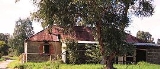
After European settlement of the Perth region in 1829, the land of much of the area including and surrounding what is now Atwell was granted to G Dunnage. The area was later part of the dairy property owned and operated for many years by Ernest Atwell. Originally it was purchased in the 1920s to spell horses he used in his livery stable business, which was conducted in Fremantle. It was later developed into one of the largest dairies in the Perth region. The huge amount of land was slowly sold off but the Dairy was still operating until the late 1950s. The house and workers cottage were eventually demolished when the area was cleared for redevelopment.
Development of the suburb of Atwell began in the early 1990s through the creation of several housing estates such as Beeliar parklands and has continued to expand with the estates, Atwell Waters, and Harvest Lakes being developed. Most of the suburb has now been developed, with only small sections in the south remaining.
Learning Community for children with special needs.
. In addition, Softball and Tee ball are also played here. Atwell and Harmony Primary school ovals are open to the public and have cricket pitches and nets.
.
/ Mandurah in the South is via the Kwinana Freeway which is accessible via interchanges at Armadale Road and Gibbs Road.
East Access to Armadale is via Armadale Road. Western access to Fremantle
is via Beeliar Drive and North Lake Road.
Perth, Western Australia
Perth is the capital and largest city of the Australian state of Western Australia and the fourth most populous city in Australia. The Perth metropolitan area has an estimated population of almost 1,700,000....
, Western Australia
Western Australia
Western Australia is a state of Australia, occupying the entire western third of the Australian continent. It is bounded by the Indian Ocean to the north and west, the Great Australian Bight and Indian Ocean to the south, the Northern Territory to the north-east and South Australia to the south-east...
, situated 21 kilometres (13 mi) south of Perth City, and located in the City of Cockburn local government area.
Geography
Situated on the Swan coastal plain, between the coast, and the Darling scarp, the terrain is generally flat , with many small natural and created wetlands. It is situated on the western boundary of the Jandakot ground water protection area, and hence suburban development to the east is not permitted. It is bounded to the north by Armadale RoadArmadale Road, Perth
Armadale Road is a major road in the south and south east of the Perth Metropolitan Area. It serves three purposes: firstly, providing a main route from Armadale to Fremantle; secondly, connecting Armadale to the Kwinana Freeway; and thirdly, since 2005, connecting it to the Tonkin Highway which...
, the Kwinana Freeway
Kwinana Freeway
The Kwinana Freeway is a major arterial road in Perth, Western Australia, linking Perth with the southern suburbs and then further on towards Mandurah, a distance of . It has a speed limit of , except in central Perth and south of Lakes Road . Like all Western Australian freeways, the minimum...
to the west, Tappers Road to the east and to the south by Gibbs Road.
History
The Whadjug Nyungar aboriginal people were the first human inhabitants of the region. Occupying the region from 40,000 years ago. The many lakes and wetlands of the region were important for sustenance and spiritually.After European settlement of the Perth region in 1829, the land of much of the area including and surrounding what is now Atwell was granted to G Dunnage. The area was later part of the dairy property owned and operated for many years by Ernest Atwell. Originally it was purchased in the 1920s to spell horses he used in his livery stable business, which was conducted in Fremantle. It was later developed into one of the largest dairies in the Perth region. The huge amount of land was slowly sold off but the Dairy was still operating until the late 1950s. The house and workers cottage were eventually demolished when the area was cleared for redevelopment.
Development of the suburb of Atwell began in the early 1990s through the creation of several housing estates such as Beeliar parklands and has continued to expand with the estates, Atwell Waters, and Harvest Lakes being developed. Most of the suburb has now been developed, with only small sections in the south remaining.
Statistics
Selected medians and averages from the 2006 census:| Class | Atwell | Perth | Australia |
|---|---|---|---|
| Median Median In probability theory and statistics, a median is described as the numerical value separating the higher half of a sample, a population, or a probability distribution, from the lower half. The median of a finite list of numbers can be found by arranging all the observations from lowest value to... age |
30 | 36 | 37 |
| Average household size (persons) | 3.1 | 2.5 | 2.6 |
| Australian born | 66.0% | 68.7% | 70.9% |
| Median individual income (weekly) | $681 | $513 | $466 |
| Median family income(weekly) | $1558 | $1086 | $1027 |
| Median rent (weekly) | $250 | $180 | $190 |
| Median housing loan repayment (monthly) | $1365 | $1300 | $1300 |
Community centres
There are two Community centres in Atwell. The Atwell Community centre and the Harvest Lakes Community Centre, situated in the grounds of the Harmony primary school.Education
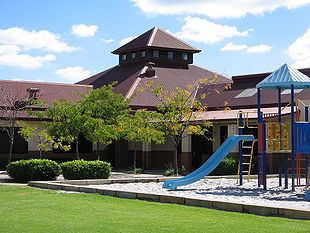
There are two primary schools in Atwell. Atwell Primary was established in 1998 and had 958 students in 2008. Harmony Primary was established in 2004 and in 2008 had 559 students. The secondary school, Atwell College, established in 2008 for years 7 to 8, had 350 students in 2008 and also incorporates the Kim BeazleyKim Edward Beazley
Kim Edward Beazley, AO , known as Kim Beazley during his career, Australian politician, was Minister for Education in the government of Gough Whitlam and a Labor member of the Australian House of Representatives for 32 years, from 1945 to 1977.Beazley, the youngest of seven children, was born in...
Learning Community for children with special needs.
Health
Atwell currently has a general practitioner's medical centre, an infant health clinic, a pharmacy and a physiotherapy clinic.Retail
There are currently two retail centres in Atwell. A small centre in the north was opened in the late 1990s, consisting of a delicatessen and a Chinese restaurant. A second larger centre was opened in central Atwell in the early 2000s consisting of a supermarket and several other food and service stores. A third centre is zoned for the southern Harvest lakes region, though no firm plans are currently in place.Leisure
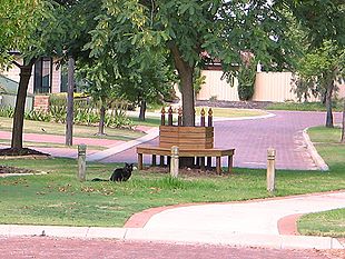
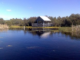
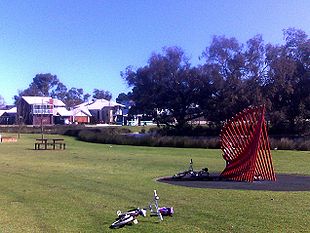
Atwell has a large number of parks and reserves. The two major parks are Atwell reserve, which has a lake, playgrounds, skate park and barbecue facilities and Harvest lakes park which has a lake and playgrounds.Sports
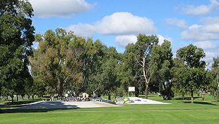
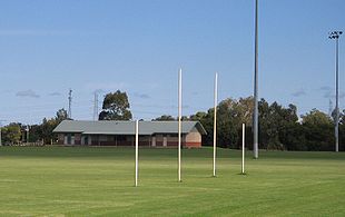
Atwell Oval is the main sporting ground and has a clubhouse and change rooms for the Jandakot Jets Football Club which plays Australian rules footballAustralian rules football
Australian rules football, officially known as Australian football, also called football, Aussie rules or footy is a sport played between two teams of 22 players on either...
. In addition, Softball and Tee ball are also played here. Atwell and Harmony Primary school ovals are open to the public and have cricket pitches and nets.
Public
Regular bus services on route 527 operate to Cockburn Central railway station, located just outside the North Western boundary of Atwell, and Gateways regional shopping centre in Success. Train services connect to Perth and MandurahMandurah, Western Australia
Mandurah is the second-largest city in Western Australia and is located approximately south of the state capital, Perth.The city attracts a large number of tourists, including many international visitors...
.
Road
Atwell is well connected with transport infrastructure, being situated adjacent to a transport hub at Perth's southern approaches. Access to Perth in the North and RockinghamRockingham, Western Australia
Rockingham is a suburb and primary centre in Western Australia south-west of the Perth city centre and south of Fremantle. It has a beachside location at Mangles Bay, the southern extremity of Cockburn Sound. To its north stretches the maritime and resource-industry installations of Kwinana and...
/ Mandurah in the South is via the Kwinana Freeway which is accessible via interchanges at Armadale Road and Gibbs Road.
East Access to Armadale is via Armadale Road. Western access to Fremantle
Fremantle
Freemantle is a suburb of Southampton in England.Fremantle or Freemantle may also refer to:- Places :* Fremantle, the port city to the capital Perth, Western Australia...
is via Beeliar Drive and North Lake Road.