
Mitchell Freeway
Encyclopedia
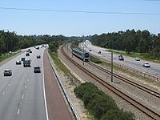
Mitchell Freeway is a 30 kilometres (18.6 mi) long freeway
in Perth, Western Australia
, linking Perth's central business district
with its outer northern suburbs. It is allocated Route 2 for its entire length and is named after former state Premier and Governor Sir James Mitchell
.
Construction of the freeway commenced in stages from the late 1960s onwards, and as of 2009, the freeway terminates at Burns Beach Road, Currambine
. The freeway is mostly 6 or 8 lanes south of Hepburn Avenue; from that point north it is mostly 4 lanes; extending to 6 between Hodges Drive and Shenton Avenue. It also forms the borders of most of the suburbs through which it passes.
The speed limit is generally 100 kilometres per hour (62.1 mph), except in central Perth where the speed limit is 80 kilometres per hour (49.7 mph). Southbound, the reduced speed section begins near the Graham Farmer Freeway
; northbound it ends near the Vincent Street exit.
The median strip of the freeway houses the Joondalup railway line, and all but two of the suburban train stations are also located in the median. Additionally, a shared pedestrian and bike path is built alongside much of the freeway.
in the mid-1950s. Its original proposed name was the Yanchep Highway, as this is where the freeway was (and still is) planned to end. The original planned route, as advertised in newspapers in 1961 and 1962, took the freeway inland from what is now Karrinyup Road to the intersection of Wanneroo
and Balcatta Roads. The section between the Narrows Bridge and Sutherland Street, commenced in 1967 and completed in 1973, was referred to as "the western switch", and functioned only as a distributor for Narrows Bridge traffic accessing the CBD or areas further north.
Several stages were built through the late 1970s, 1980s and early 1990s. In the 1970s, the freeway was extended firstly to Vincent Street - slicing the suburb of Leederville
in two - and then to Hutton Street. In 1983-84, it was extended first to Karrinyup Road, and then to Erindale Road. In 1986, the freeway was extended to Hepburn Avenue. The first stage of the Reid Highway
(then known as the North Perimeter Highway) was built at the same time. In 1988, the freeway was extended further to Ocean Reef Road.
In 1991-1992, the median strip of the entire freeway was significantly widened to accommodate the Joondalup railway line, being built under the Northern Suburbs Transit System
project. The line was to be located in the middle of the road reserve between the north and south-bound carriages. At the time, the section of freeway between Loftus Street and McDonald Streets were butted right next to each other, with space for further widening efforts of the section located on the eastern side of the road reserve. To enable this, three new rail and road bridges were constructed at Vincent, Powis, and Scarborough Beach Roads. Once the road bridges had been completed and surfacing works completed, the southbound carriage was relocated creating the required space for the railway line to continue construction. While the relevant road bridges and some associated works were included as part of the costs for the Northern Suburbs Transit System project, the addition of new lanes in the realigned section was funded from regular road funding sources.
After a 13-year-hiatus, a 3 km extension to Hodges Drive, was opened to traffic in mid-2001.
The latest extension, a 4 km stretch to Burns Beach Road with exits at Shenton Avenue and an overpass for Moore Drive, was opened on 2 November 2008 by Western Australia's Minister for Transport, Simon O'Brien, and the previous Minister for Planning and Infrastructure Alannah McTiernan. This was not without some opposition, as the original design of the extension involved building a wall several metres high, and opponents claimed the wall would be an eyesore and would physically divide the area. Plans were redrawn and construction of the extension was planned for May 2006 and began on 14 December 2006, managed by Main Roads in conjunction with Macmahon Contractors. By July 2008, 90% of the works had been completed and the new section was predicted to open in September 2008.
The opening featured more than 50 vintage cars dating from the 1920s through to the 1960s and was keenly watched by hundreds of local residents.
For most of its history, the freeway had two lanes in each direction, but various sections have been expanded to three and four lanes over the years due to increasing traffic. This happened most recently in 1999 when the section between Karrinyup Road and Hepburn Avenue became three lanes in each direction. Future lane additions are inevitable due to the large volume of traffic travelling between the city centre and the northern suburbs.
, Perth, continuing from the Kwinana Freeway
, and terminates just north of the city of Joondalup at Burns Beach Road, Currambine
. It is signed as for its entire length.
.
Controlled-access highway
A controlled-access highway is a highway designed exclusively for high-speed vehicular traffic, with all traffic flow and ingress/egress regulated...
in Perth, Western Australia
Perth, Western Australia
Perth is the capital and largest city of the Australian state of Western Australia and the fourth most populous city in Australia. The Perth metropolitan area has an estimated population of almost 1,700,000....
, linking Perth's central business district
Central business district
A central business district is the commercial and often geographic heart of a city. In North America this part of a city is commonly referred to as "downtown" or "city center"...
with its outer northern suburbs. It is allocated Route 2 for its entire length and is named after former state Premier and Governor Sir James Mitchell
James Mitchell (Australian politician)
Sir James Mitchell GCMG was the 13th Premier of Western Australia, serving on two occasions, the Lieutenant-Governor of Western Australia for 15 years and the 22nd Governor of Western Australia....
.
Construction of the freeway commenced in stages from the late 1960s onwards, and as of 2009, the freeway terminates at Burns Beach Road, Currambine
Currambine, Western Australia
Currambine is a northern suburb of Perth, the capital city of Western Australia, and is located 30 km north of Perth's central business district. Its Local Government Area is the City of Joondalup. It contains the Currambine Market Place shopping centre and cinema complex.-History:Currambine...
. The freeway is mostly 6 or 8 lanes south of Hepburn Avenue; from that point north it is mostly 4 lanes; extending to 6 between Hodges Drive and Shenton Avenue. It also forms the borders of most of the suburbs through which it passes.
The speed limit is generally 100 kilometres per hour (62.1 mph), except in central Perth where the speed limit is 80 kilometres per hour (49.7 mph). Southbound, the reduced speed section begins near the Graham Farmer Freeway
Graham Farmer Freeway
The Graham Farmer Freeway is a major part of the metropolitan road infrastructure in Perth, Western Australia. It is long and links Rivervale and East Perth with West Perth, bypassing Perth's central business district...
; northbound it ends near the Vincent Street exit.
The median strip of the freeway houses the Joondalup railway line, and all but two of the suburban train stations are also located in the median. Additionally, a shared pedestrian and bike path is built alongside much of the freeway.
History
The Mitchell Freeway began as part of the Metropolitan Region SchemeMetropolitan Region Scheme
The Metropolitan Region Scheme is the legal land plan covering urban planning throughout the Perth Metropolitan Region. It classifies land into broad zones and reservations and is administered by the Western Australian Planning Commission....
in the mid-1950s. Its original proposed name was the Yanchep Highway, as this is where the freeway was (and still is) planned to end. The original planned route, as advertised in newspapers in 1961 and 1962, took the freeway inland from what is now Karrinyup Road to the intersection of Wanneroo
Wanneroo Road
Wanneroo Road is an important arterial road in Perth, Australia. It is about 75 kilometres long. It links Perth with the City of Wanneroo, and the Towns of Yanchep and Lancelin...
and Balcatta Roads. The section between the Narrows Bridge and Sutherland Street, commenced in 1967 and completed in 1973, was referred to as "the western switch", and functioned only as a distributor for Narrows Bridge traffic accessing the CBD or areas further north.
Several stages were built through the late 1970s, 1980s and early 1990s. In the 1970s, the freeway was extended firstly to Vincent Street - slicing the suburb of Leederville
Leederville, Western Australia
Leederville is a locality within the City of Vincent within the Perth metropolitan region of Western Australia.It is home to Aranmore Catholic College, The Schools of Isolated and Distance Education, Central Institute of Technology Leederville Campus and St Mary's Church.-External...
in two - and then to Hutton Street. In 1983-84, it was extended first to Karrinyup Road, and then to Erindale Road. In 1986, the freeway was extended to Hepburn Avenue. The first stage of the Reid Highway
Reid Highway
Reid Highway is a major arterial highway in Perth, Western Australia. It is allocated Route 3, and runs between Marmion Avenue, North Beach, and West Swan Road, West Swan, a distance of...
(then known as the North Perimeter Highway) was built at the same time. In 1988, the freeway was extended further to Ocean Reef Road.
In 1991-1992, the median strip of the entire freeway was significantly widened to accommodate the Joondalup railway line, being built under the Northern Suburbs Transit System
Northern Suburbs Transit System
The Northern Suburbs Transit System is the name given to the project initiated and funded by the Government of Western Australia to provide high-speed passenger rail services to the northern corridor of metropolitan Perth, the capital city of Western Australia...
project. The line was to be located in the middle of the road reserve between the north and south-bound carriages. At the time, the section of freeway between Loftus Street and McDonald Streets were butted right next to each other, with space for further widening efforts of the section located on the eastern side of the road reserve. To enable this, three new rail and road bridges were constructed at Vincent, Powis, and Scarborough Beach Roads. Once the road bridges had been completed and surfacing works completed, the southbound carriage was relocated creating the required space for the railway line to continue construction. While the relevant road bridges and some associated works were included as part of the costs for the Northern Suburbs Transit System project, the addition of new lanes in the realigned section was funded from regular road funding sources.
After a 13-year-hiatus, a 3 km extension to Hodges Drive, was opened to traffic in mid-2001.
The latest extension, a 4 km stretch to Burns Beach Road with exits at Shenton Avenue and an overpass for Moore Drive, was opened on 2 November 2008 by Western Australia's Minister for Transport, Simon O'Brien, and the previous Minister for Planning and Infrastructure Alannah McTiernan. This was not without some opposition, as the original design of the extension involved building a wall several metres high, and opponents claimed the wall would be an eyesore and would physically divide the area. Plans were redrawn and construction of the extension was planned for May 2006 and began on 14 December 2006, managed by Main Roads in conjunction with Macmahon Contractors. By July 2008, 90% of the works had been completed and the new section was predicted to open in September 2008.
The opening featured more than 50 vintage cars dating from the 1920s through to the 1960s and was keenly watched by hundreds of local residents.
For most of its history, the freeway had two lanes in each direction, but various sections have been expanded to three and four lanes over the years due to increasing traffic. This happened most recently in 1999 when the section between Karrinyup Road and Hepburn Avenue became three lanes in each direction. Future lane additions are inevitable due to the large volume of traffic travelling between the city centre and the northern suburbs.
Exits and interchanges
The Mitchell Freeway commences at the end of the Narrows BridgeNarrows Bridge
The Narrows Bridge is a freeway crossing of the Swan River in Perth, Western Australia, at The Narrows between Mill Point and Mount Eliza. Made up of two road bridges and a railway bridge, it connects the Mitchell and Kwinana Freeways, linking the city's northern and southern suburbs...
, Perth, continuing from the Kwinana Freeway
Kwinana Freeway
The Kwinana Freeway is a major arterial road in Perth, Western Australia, linking Perth with the southern suburbs and then further on towards Mandurah, a distance of . It has a speed limit of , except in central Perth and south of Lakes Road . Like all Western Australian freeways, the minimum...
, and terminates just north of the city of Joondalup at Burns Beach Road, Currambine
Currambine, Western Australia
Currambine is a northern suburb of Perth, the capital city of Western Australia, and is located 30 km north of Perth's central business district. Its Local Government Area is the City of Joondalup. It contains the Currambine Market Place shopping centre and cinema complex.-History:Currambine...
. It is signed as
for its entire length.Perth City entrances/exits
Please update City Exits image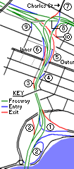 |
|
Inner & Outer Perth
| Mitchell Freeway |
|||
| Northbound exits | Distance to Currambine (km) |
Distance to Perth CBD (km) |
Southbound exits |
.svg.png)  Traffic Lights (clockwise from freeway) Traffic Lights (clockwise from freeway) Burns Beach Road  to Burns Beach to Burns BeachBurns Beach, Western Australia Burns Beach is a suburb of Perth, Western Australia, located north of Perth's central business district at the northern fringe of the City of Joondalup... (3 km) and Clarkson Clarkson, Western Australia Clarkson is an outer northern suburb of Perth, Western Australia, located 34 kilometres north of Perth's central business district. It is part of the City of Wanneroo local government area. While mostly a residential area, it also functions as a town centre, serving many surrounding areas with a... via  Marmion Avenue Marmion AvenueMarmion Avenue Marmion Avenue is a major arterial road in Perth, Western Australia, designated State Route 71.It runs through the northern coastal suburbs of Perth from the end of West Coast Highway in Trigg and Karrinyup, to the outer northern suburb of Yanchep... (10 km) Burns Beach Road to CarramarCarramar, Western Australia Carramar is a suburb of Perth, Western Australia, located within the City of Wanneroo and it is situated 29 km from the Perth CBD. Its postcode is 6031, and it came into being, together with Tapping to the south, in 1995 as a subdivision of Neerabup.... (4 km) |
|||
| End Mitchell Freeway |
0 | 29.0 | Start Mitchell Freeway |
| Currambine Currambine, Western Australia Currambine is a northern suburb of Perth, the capital city of Western Australia, and is located 30 km north of Perth's central business district. Its Local Government Area is the City of Joondalup. It contains the Currambine Market Place shopping centre and cinema complex.-History:Currambine... , Joondalup Shenton Avenue |
1.9 | 27.0 | RAIL LINE |
| Joondalup, Currambine Currambine, Western Australia Currambine is a northern suburb of Perth, the capital city of Western Australia, and is located 30 km north of Perth's central business district. Its Local Government Area is the City of Joondalup. It contains the Currambine Market Place shopping centre and cinema complex.-History:Currambine... Shenton Avenue |
|||
| Ocean Reef Ocean Reef, Western Australia Ocean Reef is a suburb in northern Perth, Western Australia. It is located within the City of Joondalup. The name was coined by developers in the 1970s from the line of a reef visible several kilometres offshore... , Joondalup Hodges Drive |
3.8 | 25.1 | Heathridge, Ocean Reef Ocean Reef, Western Australia Ocean Reef is a suburb in northern Perth, Western Australia. It is located within the City of Joondalup. The name was coined by developers in the 1970s from the line of a reef visible several kilometres offshore... Hodges Drive |
| Ocean Reef Ocean Reef, Western Australia Ocean Reef is a suburb in northern Perth, Western Australia. It is located within the City of Joondalup. The name was coined by developers in the 1970s from the line of a reef visible several kilometres offshore... , Edgewater Edgewater, Western Australia Edgewater is a suburb of Perth, Western Australia, located north of Perth's central business district. Edgewater was approved as a suburb name in 1974, and its local government area is the City of Joondalup... Ocean Reef Road  |
6.5 | 22.4 | Edgewater Edgewater, Western Australia Edgewater is a suburb of Perth, Western Australia, located north of Perth's central business district. Edgewater was approved as a suburb name in 1974, and its local government area is the City of Joondalup... , Ocean Reef Ocean Reef, Western Australia Ocean Reef is a suburb in northern Perth, Western Australia. It is located within the City of Joondalup. The name was coined by developers in the 1970s from the line of a reef visible several kilometres offshore... Ocean Reef Road |
| Padbury Padbury, Western Australia Padbury is a suburb of Perth, Western Australia, located within the City of Joondalup. Its postcode is 6025. The suburb was named in 1971 after the notable Western Australian settler Walter Padbury... , Kingsley Kingsley, Western Australia Kingsley is a suburb of Perth, Western Australia, located within the City of Joondalup. Kingsley is bounded to the north by Whitfords Avenue, to the south by Hepburn Avenue, to the west by the Mitchell Freeway and to the east by Wanneroo Road.... Whitfords Avenue  |
9.2 | 19.7 | Kingsley Kingsley, Western Australia Kingsley is a suburb of Perth, Western Australia, located within the City of Joondalup. Kingsley is bounded to the north by Whitfords Avenue, to the south by Hepburn Avenue, to the west by the Mitchell Freeway and to the east by Wanneroo Road.... , Padbury Padbury, Western Australia Padbury is a suburb of Perth, Western Australia, located within the City of Joondalup. Its postcode is 6025. The suburb was named in 1971 after the notable Western Australian settler Walter Padbury... Whitfords Avenue |
| Duncraig Duncraig, Western Australia Duncraig is a large northern suburb of Perth, the capital city of Western Australia, Australia, and is located north of Perth's central business district between Marmion Avenue and Mitchell Freeway... , Greenwood Greenwood, Western Australia Greenwood, is a suburb of Perth, Western Australia, located in the City of Joondalup. The suburb is located 18 km from Perth's central business district.-History:... Hepburn Avenue  |
11.3 | 17.6 | Greenwood Greenwood, Western Australia Greenwood, is a suburb of Perth, Western Australia, located in the City of Joondalup. The suburb is located 18 km from Perth's central business district.-History:... , Duncraig Duncraig, Western Australia Duncraig is a large northern suburb of Perth, the capital city of Western Australia, Australia, and is located north of Perth's central business district between Marmion Avenue and Mitchell Freeway... Hepburn Avenue |
| Duncraig Duncraig, Western Australia Duncraig is a large northern suburb of Perth, the capital city of Western Australia, Australia, and is located north of Perth's central business district between Marmion Avenue and Mitchell Freeway... , Warwick Warwick, Western Australia Warwick is a suburb of Perth, Western Australia, located within the City of Joondalup. Its postcode is 6024. The eastern third of the suburb is a native bushland area known as the Warwick Open Space.... Warwick Road  |
13.8 | 16.1 | Warwick Warwick, Western Australia Warwick is a suburb of Perth, Western Australia, located within the City of Joondalup. Its postcode is 6024. The eastern third of the suburb is a native bushland area known as the Warwick Open Space.... , Duncraig Duncraig, Western Australia Duncraig is a large northern suburb of Perth, the capital city of Western Australia, Australia, and is located north of Perth's central business district between Marmion Avenue and Mitchell Freeway... Warwick Road |
| North Beach North Beach, Western Australia North Beach is a northern coastal suburb of Perth, the capital city of Western Australia, and is located from Perth's central business district via Mitchell Freeway and Reid Highway. Its Local Government Area is the City of Stirling.-History:... , Midland Midland, Western Australia Midland is a suburb in the Perth, Western Australia metropolitan area, as well as the regional centre for the City of Swan local government area that covers the Swan Valley and parts of the Darling Scarp to the east. It is situated at the intersection of Great Eastern Highway and Great Northern... Reid Highway Reid Highway Reid Highway is a major arterial highway in Perth, Western Australia. It is allocated Route 3, and runs between Marmion Avenue, North Beach, and West Swan Road, West Swan, a distance of...   |
15.9 | 13.0 | Midland Midland, Western Australia Midland is a suburb in the Perth, Western Australia metropolitan area, as well as the regional centre for the City of Swan local government area that covers the Swan Valley and parts of the Darling Scarp to the east. It is situated at the intersection of Great Eastern Highway and Great Northern... , North Beach North Beach, Western Australia North Beach is a northern coastal suburb of Perth, the capital city of Western Australia, and is located from Perth's central business district via Mitchell Freeway and Reid Highway. Its Local Government Area is the City of Stirling.-History:... Reid Highway Reid Highway Reid Highway is a major arterial highway in Perth, Western Australia. It is allocated Route 3, and runs between Marmion Avenue, North Beach, and West Swan Road, West Swan, a distance of... |
| Balcatta Balcatta, Western Australia Balcatta is a suburb of Perth, Western Australia. Its Local Government Area is the City of Stirling. It is a primarily middle-class suburb made up of mainly Italian Catholic, Greek and Macedonian Orthodox families, as well as many families from other European Orthodox religions. It is also one of... Balcatta Road  |
|||
| Gwelup Gwelup, Western Australia Gwelup is a suburb of Perth, the capital city of Western Australia, and is located 12 km north of Perth's central business district along the Mitchell Freeway. Its Local Government Area is the City of Stirling.-History and Environment:... , Balcatta Balcatta, Western Australia Balcatta is a suburb of Perth, Western Australia. Its Local Government Area is the City of Stirling. It is a primarily middle-class suburb made up of mainly Italian Catholic, Greek and Macedonian Orthodox families, as well as many families from other European Orthodox religions. It is also one of... Erindale Road  |
17.5 | 11.4 | no exit |
| Stirling Stirling, Western Australia The City of Stirling is a Local Government Area in the northern suburbs of the Western Australian capital city of Perth, located about north of Perth's central business district... , Karrinyup Karrinyup, Western Australia Karrinyup is a suburb of Perth, the capital city of Western Australia, and is located 12 km north of Perth's central business district. Its Local Government Area is the City of Stirling... Karrinyup Road  |
19.0 | 9.9 | Karrinyup Karrinyup, Western Australia Karrinyup is a suburb of Perth, the capital city of Western Australia, and is located 12 km north of Perth's central business district. Its Local Government Area is the City of Stirling... , Stirling Stirling, Western Australia The City of Stirling is a Local Government Area in the northern suburbs of the Western Australian capital city of Perth, located about north of Perth's central business district... Karrinyup Road |
| Stirling Stirling, Western Australia The City of Stirling is a Local Government Area in the northern suburbs of the Western Australian capital city of Perth, located about north of Perth's central business district... , Innaloo Innaloo, Western Australia Innaloo is a suburb of Perth, the capital city of Western Australia, and it is located 9 km from Perth's central business district. Its Local Government Area is the City of Stirling.... Cedric Street  |
20.0 | 8.9 | Innaloo Innaloo, Western Australia Innaloo is a suburb of Perth, the capital city of Western Australia, and it is located 9 km from Perth's central business district. Its Local Government Area is the City of Stirling.... , Stirling Stirling, Western Australia The City of Stirling is a Local Government Area in the northern suburbs of the Western Australian capital city of Perth, located about north of Perth's central business district... Cedric Street |
| Osborne Park Osborne Park, Western Australia Osborne Park is a suburb of Perth, Western Australia. Its Local Government Area is the City of Stirling.Osborne Park was named after William Osborne, a butcher who owned an abattoir on Wanneroo Road and was elected to the Perth Road Board , in 1875.The suburb was originally full of market gardens,... Hutton Street |
22.0 | 6.3 | Osborne Park Osborne Park, Western Australia Osborne Park is a suburb of Perth, Western Australia. Its Local Government Area is the City of Stirling.Osborne Park was named after William Osborne, a butcher who owned an abattoir on Wanneroo Road and was elected to the Perth Road Board , in 1875.The suburb was originally full of market gardens,... Hutton Street |
| Cape Street | |||
| Hector Street West | Hector Street | ||
| McDonald Street West | McDonald Street | ||
| Glendalough Glendalough, Western Australia Glendalough is a suburb of Perth, Western Australia. Its Local Government Area is the City of Stirling, and is located about 6 kilometres from Perth's central business district along the Mitchell Freeway.... , Mount Hawthorn Mount Hawthorn, Western Australia Mount Hawthorn is a suburb of Perth, Western Australia, located within the City of Vincent.The Mount Hawthorn area was first selected for urban development in 1887. In the late 1890s part of it was purchased by a syndicate of Edward Wittenoom, a politician and pastoralist; James Hicks and C. L. W.... Powis Street |
24.5 | 4.4 | no exit |
| Wembley Wembley, Western Australia Wembley is a western suburb of Perth, Western Australia, located within the Town of Cambridge. Its postcode is 6014.The main streets in Wembley are Cambridge Street, Harborne Street, Grantham Street and Selby Street. It is an upper middle class, medium-density suburb. Wembley is home to Bold Park... , Leederville Leederville, Western Australia Leederville is a locality within the City of Vincent within the Perth metropolitan region of Western Australia.It is home to Aranmore Catholic College, The Schools of Isolated and Distance Education, Central Institute of Technology Leederville Campus and St Mary's Church.-External... Lake Monger Drive / Vincent Street  |
26.3 | 2.6 | Leederville Leederville, Western Australia Leederville is a locality within the City of Vincent within the Perth metropolitan region of Western Australia.It is home to Aranmore Catholic College, The Schools of Isolated and Distance Education, Central Institute of Technology Leederville Campus and St Mary's Church.-External... , Wembley Wembley, Western Australia Wembley is a western suburb of Perth, Western Australia, located within the Town of Cambridge. Its postcode is 6014.The main streets in Wembley are Cambridge Street, Harborne Street, Grantham Street and Selby Street. It is an upper middle class, medium-density suburb. Wembley is home to Bold Park... Vincent Street / Lake Monger Drive |
| no exit | 27.6 | 1.3 | East Perth East Perth, Western Australia East Perth is an inner suburb of Perth, Western Australia, located next to the Perth CBD.Primarily an industrial area in the early twentieth century, it was the location of the East Perth gas works, East Perth Power Station , the East Perth railway yard, and East Perth engine sheds.A considerable... , Burswood Burswood, Western Australia Burswood is an inner southeastern suburb of Perth, Western Australia, located immediately across the Swan River from Perth's central business district via both The Causeway and Graham Farmer Freeway... Graham Farmer Freeway Graham Farmer Freeway The Graham Farmer Freeway is a major part of the metropolitan road infrastructure in Perth, Western Australia. It is long and links Rivervale and East Perth with West Perth, bypassing Perth's central business district...  |
| no exit | 27.8 | 1.1 | James Street |
| Perth CBD Perth, Western Australia Perth is the capital and largest city of the Australian state of Western Australia and the fourth most populous city in Australia. The Perth metropolitan area has an estimated population of almost 1,700,000.... , West Perth West Perth, Western Australia West Perth is an inner suburb of Perth, the capital city of Western Australia. It is part of the inner mixed zone, and has predominantly office blocks which have displaced residential buildings. There is a high proportion of miners and consultants, and particularly medical specialists, compared to... Wellington Street Wellington Street, Perth Wellington Street is the northernmost of the four primary east-west streets in the central business district of Perth, Western Australia. It contains several of Perth's key facilities, including the new Harbour Town shopping development, the Wellington Street Bus Station and the Perth railway...  |
|||
| East Perth East Perth, Western Australia East Perth is an inner suburb of Perth, Western Australia, located next to the Perth CBD.Primarily an industrial area in the early twentieth century, it was the location of the East Perth gas works, East Perth Power Station , the East Perth railway yard, and East Perth engine sheds.A considerable... , Burswood Burswood, Western Australia Burswood is an inner southeastern suburb of Perth, Western Australia, located immediately across the Swan River from Perth's central business district via both The Causeway and Graham Farmer Freeway... Graham Farmer Freeway Graham Farmer Freeway The Graham Farmer Freeway is a major part of the metropolitan road infrastructure in Perth, Western Australia. It is long and links Rivervale and East Perth with West Perth, bypassing Perth's central business district... |
28.1 | 0.8 | no exit |
| North Perth North Perth, Western Australia North Perth is a suburb of Perth, Western Australia, located within the City of Vincent.This old, established suburb just three kilometres north of Perth’s CBD is a place of mainly solid brick homes built from the early 1900s, many of which are now undergoing extensive renovations in line with the... , Yokine Yokine, Western Australia Yokine is a suburb of Perth, Western Australia. Its Local Government Area is the City of Stirling.-History:The name Yokine was derived from the Aboriginal word meaning native dog. The name was chosen because the area is close to Dog Swamp. Its post code is 6060.Yokine was part of the grant... Charles Street Wanneroo Road Wanneroo Road is an important arterial road in Perth, Australia. It is about 75 kilometres long. It links Perth with the City of Wanneroo, and the Towns of Yanchep and Lancelin...  |
|||
| Market Street | 28.3 | 0.6 | no exit |
| Hay Street Hay Street, Perth Hay Street is a major road through the CBD of Perth, Western Australia. The street was named after Robert William Hay, the Permanent Under Secretary for Colonies. Sections of the road were called Howick Street and Twiss Street until 1897... |
28.8 | -- | no exit |
| Nedlands Nedlands, Western Australia The City of Nedlands is a Local Government Area in the inner western suburbs of the Western Australian capital city of Perth, located about west of Perth's central business district... , Perth CBD Perth, Western Australia Perth is the capital and largest city of the Australian state of Western Australia and the fourth most populous city in Australia. The Perth metropolitan area has an estimated population of almost 1,700,000.... Mounts Bay Road  |
29.3 | -- | Perth CBD Perth, Western Australia Perth is the capital and largest city of the Australian state of Western Australia and the fourth most populous city in Australia. The Perth metropolitan area has an estimated population of almost 1,700,000.... Riverside Drive |
| Nedlands Nedlands, Western Australia The City of Nedlands is a Local Government Area in the inner western suburbs of the Western Australian capital city of Perth, located about west of Perth's central business district... , Fremantle Fremantle Freemantle is a suburb of Southampton in England.Fremantle or Freemantle may also refer to:- Places :* Fremantle, the port city to the capital Perth, Western Australia... Mounts Bay Road |
|||
| SWAN RIVER Swan River (Western Australia) The Swan River estuary flows through the city of Perth, in the south west of Western Australia. Its lower reaches are relatively wide and deep, with few constrictions, while the upper reaches are usually quite narrow and shallow.... |
30.2 | -- | SWAN RIVER Swan River (Western Australia) The Swan River estuary flows through the city of Perth, in the south west of Western Australia. Its lower reaches are relatively wide and deep, with few constrictions, while the upper reaches are usually quite narrow and shallow.... |
| Start Mitchell Freeway from Kwinana Freeway Kwinana Freeway The Kwinana Freeway is a major arterial road in Perth, Western Australia, linking Perth with the southern suburbs and then further on towards Mandurah, a distance of . It has a speed limit of , except in central Perth and south of Lakes Road . Like all Western Australian freeways, the minimum... |
End Mitchell Freeway continues as Kwinana Freeway Kwinana Freeway The Kwinana Freeway is a major arterial road in Perth, Western Australia, linking Perth with the southern suburbs and then further on towards Mandurah, a distance of . It has a speed limit of , except in central Perth and south of Lakes Road . Like all Western Australian freeways, the minimum... to Mandurah Mandurah, Western Australia Mandurah is the second-largest city in Western Australia and is located approximately south of the state capital, Perth.The city attracts a large number of tourists, including many international visitors... |
||
Future widening
The State Government has committed $30m for the widening of the northbound Mitchell Freeway from Hepburn Avenue to Hodges Drive from 2 lanes to 3 lanes in its 2011/12 budget. Works are set to begin in 2012. .Future extensions
The freeway's design has allowed for a long area of vacant land for future freeway extensions. The Mitchell Freeway is expected to follow north to the currently new developed areas such as Ridgewood, Butler and Jindalee. Future exits are planned at Neerabup Road, Hester Avenue, Lukin Drive, Romeo Road and Pipidinny Road, which all are currently either proposed, incomplete or single carriageway. By as late as 2020, depending on the timing of the Alkimos/Eglinton satellite city, the Yanchep/Two Rocks/St Andrews satellite city and further coastal development, the freeway could be developed as far as Two RocksTwo Rocks, Western Australia
Two Rocks is an outer suburb of Perth, Western Australia, located 61 kilometres north of Perth's central business district. It is part of the City of Wanneroo local authority and straddles the northernmost boundaries of the Perth metropolitan area....
.
See also
- Kwinana FreewayKwinana FreewayThe Kwinana Freeway is a major arterial road in Perth, Western Australia, linking Perth with the southern suburbs and then further on towards Mandurah, a distance of . It has a speed limit of , except in central Perth and south of Lakes Road . Like all Western Australian freeways, the minimum...
- Freeways in AustraliaFreeways in AustraliaThis is a list of freeways and motorways in Australia, sorted by states and territories and their corresponding routes. This list includes toll roads such as the CityLink freeway system in Melbourne. This list has over 70 entries...
- Freeways in Western Australia
External links
- State Library of Western Australia Pictorial Collection of historical Mitchell Freeway Photographs