
Narrows Bridge
Encyclopedia
Swan River (Western Australia)
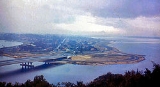
The Swan River estuary flows through the city of Perth, in the south west of Western Australia. Its lower reaches are relatively wide and deep, with few constrictions, while the upper reaches are usually quite narrow and shallow....
in Perth
Perth, Western Australia
Perth is the capital and largest city of the Australian state of Western Australia and the fourth most populous city in Australia. The Perth metropolitan area has an estimated population of almost 1,700,000....
, Western Australia
Western Australia
Western Australia is a state of Australia, occupying the entire western third of the Australian continent. It is bounded by the Indian Ocean to the north and west, the Great Australian Bight and Indian Ocean to the south, the Northern Territory to the north-east and South Australia to the south-east...
, at The Narrows between Mill Point and Mount Eliza
Mount Eliza, Western Australia
Mount Eliza is a hill which overlooks the city of Perth, Western Australia and forms part of Kings Park. It is known as Kaarta gar-up and Mooro Katta in the local Noongar dialect....
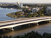
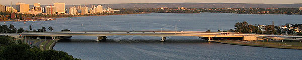
. Made up of two road bridges and a railway bridge, it connects the Mitchell
Mitchell Freeway
Mitchell Freeway is a long freeway in Perth, Western Australia, linking Perth's central business district with its outer northern suburbs. It is allocated Route 2 for its entire length and is named after former state Premier and Governor Sir James Mitchell....
and Kwinana Freeway
Kwinana Freeway
The Kwinana Freeway is a major arterial road in Perth, Western Australia, linking Perth with the southern suburbs and then further on towards Mandurah, a distance of . It has a speed limit of , except in central Perth and south of Lakes Road . Like all Western Australian freeways, the minimum...
s, linking the city's northern and southern suburbs. The original road bridge was opened in 1959 and was the largest precast
Precast concrete
By producing precast concrete in a controlled environment , the precast concrete is afforded the opportunity to properly cure and be closely monitored by plant employees. Utilizing a Precast Concrete system offers many potential advantages over site casting of concrete...
prestressed concrete
Prestressed concrete
Prestressed concrete is a method for overcoming concrete's natural weakness in tension. It can be used to produce beams, floors or bridges with a longer span than is practical with ordinary reinforced concrete...
bridge in the world. Construction of the northern interchange for this bridge necessitated the reclamation
Land reclamation
Land reclamation, usually known as reclamation, is the process to create new land from sea or riverbeds. The land reclaimed is known as reclamation ground or landfill.- Habitation :...
of a large amount of land from the river.
The bridge formed part of the Kwinana Freeway
Kwinana Freeway
The Kwinana Freeway is a major arterial road in Perth, Western Australia, linking Perth with the southern suburbs and then further on towards Mandurah, a distance of . It has a speed limit of , except in central Perth and south of Lakes Road . Like all Western Australian freeways, the minimum...
which originally ran for only 2.4 miles (3.9 km). Over the following decades, the freeway system was expanded to the north and south, greatly increasing the volume of traffic using the bridge. As a result, in 2001, a duplicate traffic bridge was opened to the west of the original bridge, and in 2005, the railway bridge was constructed in the gap between the two traffic bridges. Passenger trains first traversed the Narrows in 2007 with the opening of the Mandurah railway line.
First road bridge: 1959
Australian pound
The pound was the currency of Australia from 1910 until 13 February 1966, when it was replaced by the Australian dollar. It was subdivided into 20 shillings, each of 12 pence.- Earlier Australian currencies :...
13,000 was deemed too expensive. Preliminary planning for a bridge at the site finally began in 1947, but was suspended so that a replacement, The Causeway
The Causeway
The Causeway is the name of the traffic crossing of the Swan River in Western Australia at the eastern end of Perth Water. Made up of two bridges on either side of Heirisson Island, the crossing links the City of Perth and Victoria Park....
, could be built at Heirisson Island
Heirisson Island
Heirisson Island is an island in the Swan River in Western Australia at the eastern end of Perth Water . The city of Perth and the Town of Victoria Park are linked by The Causeway which is actually two bridges which span the two foreshores and the island...
, at the city's eastern end. The new Causeway bridges were opened in 1952, and by 1954 traffic using them to enter the city had doubled, renewing calls for a bridge at The Narrows.
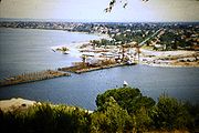
Site investigations for the bridge began in August 1954. The bridge was proposed for The Narrows site by the Town Planning Commission under the chairmanship of Harold Boas. The chosen site drew public protest on the basis that the bridge would spoil the view to and from the city. Also, residents of the wealthy Mill Point area were angry that they would have a major highway running beside their houses. The site also necessitated the reclamation
Land reclamation
Land reclamation, usually known as reclamation, is the process to create new land from sea or riverbeds. The land reclaimed is known as reclamation ground or landfill.- Habitation :...
of 60 acres (24.3 ha) of land from Mounts Bay for the bridge approach and interchange. This land reclamation, which started in October 1954, saw the addition of 4500000 cubic yards (3,440,496.9 m³) of sand, much of which was dredged from Melville Water
Melville Water
Melville Water is a significant section of the Swan River in Perth, Western Australia. It is located west of and downstream of Perth Water from which it is separated by the Narrows Bridge.-Name:...
.
The State started saving for the new bridge in September 1954, and the construction of the bridge was approved by the Hawke
Albert Hawke
Albert Redvers George Hawke was the 18th Premier of Western Australia.Hawke was born to James Renfrey Hawke and Eliza Ann Blinman Pascoe, both of Cornish descent, in Kapunda, South Australia...
state Labor government in November 1954, before the Hepburn-Stephenson metropolitan roads plan had been finalised, such was the urgency of a new traffic link. The construction of the bridge was subsequently endorsed in the 1955 Hepburn–Stephenson plan, which later developed into the Metropolitan Region Scheme
Metropolitan Region Scheme
The Metropolitan Region Scheme is the legal land plan covering urban planning throughout the Perth Metropolitan Region. It classifies land into broad zones and reservations and is administered by the Western Australian Planning Commission....
.
The river bed at the site of the proposed bridge was not ideal for bridge building, with soft mud extending down up to 80 feet (24.4 m), with sand beds below that going a further 40 feet (12.2 m) down. Ernie Godfrey, a bridge engineer with the Main Roads Department, travelled overseas to inspect bridges in similar geological locations and to source a designer for the proposed bridge. The design contract for the bridge was won by British engineering firm Maunsell & Co.
Construction on the road system began in 1956, and the contract for construction of the bridge was signed by Commissioner of Main Roads J. Digby Leach on 16 March 1957. The bridge was built by Danish
Denmark
Denmark is a Scandinavian country in Northern Europe. The countries of Denmark and Greenland, as well as the Faroe Islands, constitute the Kingdom of Denmark . It is the southernmost of the Nordic countries, southwest of Sweden and south of Norway, and bordered to the south by Germany. Denmark...
firm Christiani and Nielsen
Christiani & Nielsen
Christiani & Nielsen is a construction contractor with major operations in Thailand and Southeast Asia. Originally a Danish company, it is today a listed company majority owned by the Crown Property Bureau of King Bhumibol of Thailand....
in conjunction with Western Australian engineering firm J. O. Clough & Son
Clough Engineering Limited
Clough Limited is an international public company based in Perth, Western Australia with projects in engineering, construction, operation and maintenance services, principally in the oil and gas industry. .- History :...
. Leif Ott Nilsen oversaw construction on behalf of Christiani and Nielsen. The first timber pile
Deep foundation
A deep foundation is a type of foundation distinguished from shallow foundations by the depth they are embedded into the ground. There are many reasons a geotechnical engineer would recommend a deep foundation over a shallow foundation, but some of the common reasons are very large design loads, a...
for the temporary staging for the construction was driven at noon on 8 June 1957. The first permanent pile for the bridge was driven home on 18 August 1957. Work on the bridge's precast concrete
Precast concrete
By producing precast concrete in a controlled environment , the precast concrete is afforded the opportunity to properly cure and be closely monitored by plant employees. Utilizing a Precast Concrete system offers many potential advantages over site casting of concrete...
beams began in September 1957, and the first of these was lifted into place by the 60 feet (18.3 m) gantry crane
Gantry crane
Gantry cranes, bridge cranes, and overhead cranes, are all types of cranes which lift objects by a hoist which is fitted in a hoist trolley and can move horizontally on a rail or pair of rails fitted under a beam...
in February 1958. The last river pile was driven home in November 1958, and the final concrete beam was lowered into position in June 1959.
During construction on 10 February 1959, John Tonkin
John Tonkin
John Trezise Tonkin AC , popularly known as "Honest John", was the 20th Premier of Western Australia , taking power after the almost 12 year term of Liberal Sir David Brand....
, then the Deputy Premier and Minister for Works, announced that the new bridge was to be named the Golden West Bridge. However, Golden West was also the name for a popular soft drink
Soft drink
A soft drink is a non-alcoholic beverage that typically contains water , a sweetener, and a flavoring agent...
; the proposal encountered scorn from commentators and was quietly dropped.
The bridge cost £1.5 million, as part of a wider road system costing £3.5 million. Construction on the bridge took 2 years and 5 months. It was officially opened by Governor
Governor of Western Australia
The Governor of Western Australia is the representative in Western Australia of Australia's Monarch, Queen Elizabeth II. The Governor performs important constitutional, ceremonial and community functions, including:* presiding over the Executive Council;...
Sir Charles Gairdner
Charles Gairdner
General Sir Charles Henry Gairdner, GBE, KCMG, KCVO, CB was a British Army general during World War II and was Governor of Western Australia from 1951 to 1963, and Governor of Tasmania from 1963 to 1968.-Early life:...
on 13 November 1959. He unveiled a plaque on the bridge together with Premier
Premier of Western Australia
The Premier of Western Australia is the head of the executive government in the Australian State of Western Australia. The Premier has similar functions in Western Australia to those performed by the Prime Minister of Australia at the national level, subject to the different Constitutions...
Sir David Brand
David Brand
Sir David Brand KCMG was the 19th and longest serving Premier of Western Australia and a Member of the Legislative Assembly from 1945 to 1975.-Early life:...
, Commissioner of Main Roads J. Digby Leach and Works Minister Wild. Gairdner was also the first person to drive across the new bridge. It was hoped at this stage that the debt raised to pay for the bridge would be repaid by the Government within 12 months.
The bridge formed part of the new Kwinana Freeway, which originally ran 2.4 miles (3.9 km) from the Narrows to Canning Highway
Canning Highway
Canning Highway is a mostly 4 lane single carriageway major arterial road in Perth, Western Australia. The speed limit is 60 km/h. It is located south of the Swan River and links Perth with Fremantle, running between The Causeway in Victoria Park and Queen Victoria Street in...
. This was described as the "most modern highway" in Western Australia, with a speed limit of 50 miles per hour (80.5 km/h). The bridge was also the largest precast prestressed concrete bridge in the world at the time of its opening.
Design
The bridge was jointly designed by engineering firm G. Maunsell & PartnersGuy Maunsell
Guy Anson Maunsell was the British civil engineer responsible for the design of the World War II Naval Sea Forts and Army Forts used by the United Kingdom for the defence of the Thames and Mersey estuaries....
and architects William Halford & Partners. The prestressed concrete design was relatively new for Western Australia, where road bridges had traditionally been built from timber frameworks. The bridge is arched
Arch
An arch is a structure that spans a space and supports a load. Arches appeared as early as the 2nd millennium BC in Mesopotamian brick architecture and their systematic use started with the Ancient Romans who were the first to apply the technique to a wide range of structures.-Technical aspects:The...
along its length, with a vertical curve of up to 4% grade.
The unusually soft soil conditions at the site forced the use 160 "Gambia piles" for the bridge's foundations, named after the country in which they were first used. The 31 inches (78.7 cm) diameter piles have steel shells and conical noses. The hollow piles were driven by a drop hammer falling within them, then when they had sufficient resistance to driving, they were filled with reinforced concrete.
The piles support two river piers, two shore piers and two abutments. The bridge's support columns on the piers were designed in a triangular form, larger at the top than at the bottom, each carrying two of the bridge's beams, so as to not completely obstruct the view through the bridge's piers. These columns support the bridge's five spans: a central span of 320 feet (97.5 m), two flanking spans of 230 feet (70.1 m) each and two smaller spans of 160 feet (48.8 m) at each end passing over roadways. The bridge has eight parallel lines of beams. Each line of beams consists of two cantilever spans 370 feet (112.8 m) long suspended between the shore and river piers, a central suspended span 140 feet (42.7 m) long between the two river piers, and two 110 feet (33.5 m) spans suspended over roadways at either end. Suspended between the beams of the bridge were 1 miles (1.6 km) of 30 inches (76.2 cm) water mains
Water supply network
A water supply system or water supply network is a system of engineered hydrologic and hydraulic components which provide water supply. A water supply system typically includes:# A drainage basin ;...
pipes and 0.5 miles (804.7 m) of 10.5 inches (26.7 cm) gas and drainage pipes.
Footpaths 8 feet (2.4 m) wide on either side of the bridge were formed by concrete cast in situ
In situ
In situ is a Latin phrase which translated literally as 'In position'. It is used in many different contexts.-Aerospace:In the aerospace industry, equipment on board aircraft must be tested in situ, or in place, to confirm everything functions properly as a system. Individually, each piece may...
and cantilevered
Cantilever
A cantilever is a beam anchored at only one end. The beam carries the load to the support where it is resisted by moment and shear stress. Cantilever construction allows for overhanging structures without external bracing. Cantilevers can also be constructed with trusses or slabs.This is in...
out from the adjacent beams. These footpaths were separated from the roadway and the bridge's edge by lightweight aluminium
Aluminium
Aluminium or aluminum is a silvery white member of the boron group of chemical elements. It has the symbol Al, and its atomic number is 13. It is not soluble in water under normal circumstances....
balustrades and safety fences installed by Bristile. The street lights were integrated into the safety fence.
The deck of the bridge was formed by pre-casting individual concrete units on the southern river shore, then hoisting them into place on temporary timber staging in the river. The units were then structurally joined by strands of high-tensile wire and stretched with a hydraulic jack. These pre-stressing strands were anchored in reinforced concrete blocks at the ends of the spans. The new bridge had a traffic capacity of 6,000 cars per hour in each direction, over a total of six traffic lanes.
Post-completion history
Strengthening works were carried out on the bridge by Structural Systems Ltd in 1996. Also in 1996, decorative night lighting was installed on each side of the bridge. The bridge was entered on the state's heritage register on 8 January 1999, and was named a national engineering landmark by the Institution of Engineers, Australia, in November 1999.The opening of the southern regions of Perth to easier central business district
Central business district
A central business district is the commercial and often geographic heart of a city. In North America this part of a city is commonly referred to as "downtown" or "city center"...
access changed the nature of the metropolitan area, prompting dramatic population growth south of the river. This led to increased traffic on the bridge, causing regular traffic jams
Traffic congestion
Traffic congestion is a condition on road networks that occurs as use increases, and is characterized by slower speeds, longer trip times, and increased vehicular queueing. The most common example is the physical use of roads by vehicles. When traffic demand is great enough that the interaction...
in peak hour
Rush hour
A rush hour or peak hour is a part of the day during which traffic congestion on roads and crowding on public transport is at its highest. Normally, this happens twice a day—once in the morning and once in the evening, the times during when the most people commute...
. Over the years, governments suggested various ideas to reduce the traffic using the bridge, including introducing congestion pricing
Congestion pricing
Congestion pricing or congestion charges is a system of surcharging users of a transport network in periods of peak demand to reduce traffic congestion. Examples include some toll-like road pricing fees, and higher peak charges for utilities, public transport and slots in canals and airports...
similar to that used in Singapore
Electronic Road Pricing
The Electronic Road Pricing scheme is an electronic toll collection scheme adopted in Singapore to manage traffic by road pricing, and as a usage-based taxation mechanism to complement the purchase-based Certificate of Entitlement system...
, charging vehicles to enter the central business district during peak periods. The government also encouraged voluntary car sharing
Carsharing
Car sharing or Carsharing is a model of car rental where people rent cars for short periods of time, often by the hour. They are attractive to customers who make only occasional use of a vehicle, as well as others who would like occasional access to a vehicle of a different type than they use...
. These efforts were largely unsuccessful, and by the 1990s, the bridge had become the city's worst traffic bottleneck, despite the addition of an extra traffic lane, bringing the total number of lanes to seven.
Second road bridge: 2001
Plans for a second Narrows Bridge were mooted during the 1970s, but did not eventuate. By 1998, the original bridge was carrying 155,000 vehicles per day, with an average of 2,700 cars per lane between 7:30 am and 8:30 am, and was thought to be the busiest section of freeway in the country. This quantity of traffic far outstripped the expected capacity of the bridge when it opened in 1959. The solution to the traffic problem most favoured by road planners in 1998 was to widen the existing bridge by building a smaller second traffic bridge just west from it and joining their decks to form a contiguous roadway. This would increase the number of traffic lanes from seven to 10. The widening was expected to cost $Australian dollar
The Australian dollar is the currency of the Commonwealth of Australia, including Christmas Island, Cocos Islands, and Norfolk Island, as well as the independent Pacific Island states of Kiribati, Nauru and Tuvalu...
50 million.
A plan to widen the Narrows Bridge was announced on 13 April 1998 by the Court
Richard Court
Richard Fairfax Court AC , was a Western Australian politician, representing the seat of Nedlands in the Western Australian Legislative Assembly for the Liberal Party of Australia from 1982 to 2001. He served as Premier of Western Australia from 1993 to 2001.Court was born into an old political...
Liberal State Government. The $70 million plan would involve the addition of four extra traffic lanes, and was part of a $230 million package upgrading and extending the southern end of the Kwinana Freeway. Alannah McTiernan, then the Opposition Transport spokesperson, attacked the plan, saying that the government should instead build a railway to Rockingham
Rockingham, Western Australia
Rockingham is a suburb and primary centre in Western Australia south-west of the Perth city centre and south of Fremantle. It has a beachside location at Mangles Bay, the southern extremity of Cockburn Sound. To its north stretches the maritime and resource-industry installations of Kwinana and...
.
Instead of widening the existing structure, Transport Minister Eric Charlton on 15 July 1998 approved the construction of a separate second road bridge alongside the original Narrows Bridge; this solution would cost $15 million less, due to new building techniques, and would be less disruptive to traffic on the existing bridge. The construction of a separate bridge was also deemed necessary because the foundations of any new structure might settle in the soft river bed at a different rate to the existing bridge. Under the plan, there would be six lanes on each bridge, including a bus lane
Bus lane
A bus lane or bus only lane is a lane restricted to buses, and generally used to speed up public transport that would be otherwise held up by traffic congestion...
on each. The new bridge would run parallel to the original bridge and be separated from it by a gap of 6 metres (19.7 ft), and was designed to look largely the same as the original.
Main Roads called for tenders for the bridge widening in July 1998, and on 7 March 1999 it was announced that the building contract had been awarded to Leighton Contractors
Leighton Holdings
Leighton Holdings is Australia's largest project development and contracting group. It is active in the telecommunications, engineering and infrastructure, building and property, mining and resources, and environmental services industries...
. The negotiated contract price was reduced to $49 million owing to the construction method proposed by Leighton. The designers were Connell Wagner.
The bridge was constructed by the incremental launching technique, with 28 metres (91.9 ft) segments pre-cast on both shores and pushed out into place as the construction progressed. The bridge was divided into two strips lengthways, with the eastern half launched separately from the western half, and the two decks were later joined at the bridge's centre line. The first of twelve segments was launched in February 2000.
As it was being launched, the bridge rested on temporary piles; only after the structure was fully launched were these piles removed and the bridge allowed to rest on its permanent supports. The construction required the driving of around 250 steel piles; the first was driven on 10 August 1999.
Construction of the second bridge was interrupted several times by strikes
Strike action
Strike action, also called labour strike, on strike, greve , or simply strike, is a work stoppage caused by the mass refusal of employees to work. A strike usually takes place in response to employee grievances. Strikes became important during the industrial revolution, when mass labour became...
, as well as by an algal bloom
Algal bloom
An algal bloom is a rapid increase or accumulation in the population of algae in an aquatic system. Algal blooms may occur in freshwater as well as marine environments. Typically, only one or a small number of phytoplankton species are involved, and some blooms may be recognized by discoloration...
in the Swan River. The bridge was finally opened to traffic on 26 February 2001, and officially opened by new Transport Minister Alannah McTiernan (a strident critic of the project) on 30 May 2001. The bridge had originally been planned to be opened in August 2000, and was expected to carry 80,000 cars per day. The new traffic bridge carried six lanes of traffic, including one bus lane, and the original bridge was modified at this time to carry six traffic lanes, as designed.
Railway bridge: 2005
During the construction of the second road bridge, the construction of a railway through Perth's southern suburbs to RockinghamRockingham, Western Australia
Rockingham is a suburb and primary centre in Western Australia south-west of the Perth city centre and south of Fremantle. It has a beachside location at Mangles Bay, the southern extremity of Cockburn Sound. To its north stretches the maritime and resource-industry installations of Kwinana and...
and Mandurah
Mandurah, Western Australia
Mandurah is the second-largest city in Western Australia and is located approximately south of the state capital, Perth.The city attracts a large number of tourists, including many international visitors...
became a political issue. The incumbent Liberal
Liberal Party of Australia
The Liberal Party of Australia is an Australian political party.Founded a year after the 1943 federal election to replace the United Australia Party, the centre-right Liberal Party typically competes with the centre-left Australian Labor Party for political office...
State Government proposed building a railway from Kenwick
Kenwick, Western Australia
Kenwick, Western Australia is a mixed residential, light industrial and semi-rural suburb located in the south-east of Perth, Western Australia, located within the City of Gosnells...
to connect to the Kwinana Freeway, running in the centre of the freeway for only part of its journey. The Labor
Australian Labor Party
The Australian Labor Party is an Australian political party. It has been the governing party of the Commonwealth of Australia since the 2007 federal election. Julia Gillard is the party's federal parliamentary leader and Prime Minister of Australia...
opposition instead wanted to build the railway across the Narrows Bridge and down most of the length of the freeway.
After the Labor party won the 2001 state election
Western Australian state election, 2001
Elections were held in the state of Western Australia on 10 February 2001 to elect all 57 members to the Legislative Assembly and all 34 members to the Legislative Council...
, they reversed the previous government's position and started planning for the installation of railway tracks across the Narrows Bridge. Leighton Constructions won the contract to build the freeway stage of the railway line and set about constructing a narrow southbound railway bridge in the 6 metres (19.7 ft) gap between the existing road bridges. The designers of "Package E" of the Southern Suburbs Railway (which included the Narrows Rail Bridge) were GHD
GHD Group
GHD Pty Ltd is an engineering, architecture and environmental consulting firm.Established in 1928, GHD employs more than 6000 people across five continents and serves clients in the global markets of water, energy and resources, environment, property and buildings, and transportation.The company...
, Coffey Geosciences and Wyche Consulting. The eastern side of the existing northbound (2001) bridge was also strengthened to accommodate the northbound railway track. Construction was due to start in July 2005 and completion was expected by December 2005. The first passengers traversed the Narrows on 23 December 2007 with the opening of the Mandurah Railway Line.
The railway bridge deck was made from nine steel girders each weighing up to 99.5 tonnes (219,360 lb) and up to 54 metres (177.2 ft) long. These girders were built in Kwinana
Kwinana, Western Australia
The Town of Kwinana is a Local Government Area of Western Australia. It covers an area of approximately 118 square kilometres in metropolitan Perth, and lies about 38 km south of Perth's central business district, via the Kwinana Freeway...
, brought to the site by road and lowered into position with a crane.
External links
- State Library of Western Australia Pictorial Collection — photographs of the bridges under construction
- Western Australian Register of Heritage Places listing for the original bridge
- Structurae page on the original bridge