
Kootenai County, Idaho
Encyclopedia
Kootenai County is a county located in the U.S. state
of Idaho
. The county was established in 1864, named after Kootenai
tribe
. The entire county comprises the Coeur d'Alene
, Idaho Metropolitan Statistical Area
. The population was 138,494 at the 2010 census. The county seat
and largest city is Coeur d'Alene
.
Directly west across the state border is the Spokane
, Washington Metropolitan Statistical Area, comprising Spokane County
, Washington; the combined population of the two counties was estimated at 608,074 in 2009.
. Kootenai County is part of the Inland Empire
in the Idaho Panhandle
.
. It was named after the Kootenai
, because it lies in the traditional area of settlement of the tribe.
Once comprising most of the western Panhandle
, the county's present boundaries were established in 1915, following the formation of Benewah County
to the south.
Directly east of Kootenai County is Shoshone County
and the Silver Valley, which has had a history of disputes between miners and mine owners
.
of 2000, there were 108,685 people, 41,308 households, and 29,659 families residing in the county. The population density
was 87 people per square mile (34/km²). There were 46,607 housing units at an average density of 37 per square mile (14/km²). The racial makeup of the county was 95.84% White
, 0.17% Black
or African American
, 1.23% Native American
, 0.50% Asian
, 0.07% Pacific Islander
, 0.59% from other races
, and 1.60% from two or more races. 2.33% of the population were Hispanic
or Latino
of any race. 23.2% were of German
, 11.9% English
, 10.9% Irish
, 9.4% American
and 6.1% Norwegian ancestry according to Census 2000. 96.6% spoke English
and 1.7% Spanish
as their first language.
There were 41,308 households out of which 34.90% had children under the age of 18 living with them, 58.60% were married couples
living together, 9.20% had a female householder with no husband present, and 28.20% were non-families. 21.90% of all households were made up of individuals and 8.30% had someone living alone who was 65 years of age or older. The average household size was 2.60 and the average family size was 3.03.
In the county the population was spread out with 27.10% under the age of 18, 8.70% from 18 to 24, 28.00% from 25 to 44, 23.90% from 45 to 64, and 12.30% who were 65 years of age or older. The median age was 36 years. For every 100 females there were 98.10 males. For every 100 females age 18 and over, there were 94.90 males.
The median income for a household in the county was $37,754, and the median income for a family was $42,905. Males had a median income of $33,661 versus $22,113 for females. The per capita income
for the county was $18,430. About 7.70% of families and 10.50% of the population were below the poverty line, including 12.90% of those under age 18 and 7.30% of those age 65 or over.
U.S. state
A U.S. state is any one of the 50 federated states of the United States of America that share sovereignty with the federal government. Because of this shared sovereignty, an American is a citizen both of the federal entity and of his or her state of domicile. Four states use the official title of...
of Idaho
Idaho
Idaho is a state in the Rocky Mountain area of the United States. The state's largest city and capital is Boise. Residents are called "Idahoans". Idaho was admitted to the Union on July 3, 1890, as the 43rd state....
. The county was established in 1864, named after Kootenai
Kootenai (tribe)
The Ktunaxa , also known as Kootenai, Kutenai or Kootenay , are an indigenous people of North America. They are one of three tribes of the Confederated Salish and Kootenai Tribes of the Flathead Nation in Montana, and they form the Ktunaxa Nation in British Columbia...
tribe
Native Americans in the United States
Native Americans in the United States are the indigenous peoples in North America within the boundaries of the present-day continental United States, parts of Alaska, and the island state of Hawaii. They are composed of numerous, distinct tribes, states, and ethnic groups, many of which survive as...
. The entire county comprises the Coeur d'Alene
Coeur d'Alene, Idaho
Coeur d'Alene is the largest city and county seat of Kootenai County, Idaho, United States. It is the principal city of the Coeur d'Alene Metropolitan Statistical Area. Coeur d'Alene has the second largest metropolitan area in the state of Idaho. As of the 2010 census the population of Coeur...
, Idaho Metropolitan Statistical Area
United States metropolitan area
In the United States a metropolitan statistical area is a geographical region with a relatively high population density at its core and close economic ties throughout the area. Such regions are not legally incorporated as a city or town would be, nor are they legal administrative divisions like...
. The population was 138,494 at the 2010 census. The county seat
County seat
A county seat is an administrative center, or seat of government, for a county or civil parish. The term is primarily used in the United States....
and largest city is Coeur d'Alene
Coeur d'Alene, Idaho
Coeur d'Alene is the largest city and county seat of Kootenai County, Idaho, United States. It is the principal city of the Coeur d'Alene Metropolitan Statistical Area. Coeur d'Alene has the second largest metropolitan area in the state of Idaho. As of the 2010 census the population of Coeur...
.
Directly west across the state border is the Spokane
Spokane, Washington
Spokane is a city located in the Northwestern United States in the state of Washington. It is the largest city of Spokane County of which it is also the county seat, and the metropolitan center of the Inland Northwest region...
, Washington Metropolitan Statistical Area, comprising Spokane County
Spokane County, Washington
Spokane County is a county located in the U.S. state of Washington, named after the Spokane tribe. As of the 2010 census the population was 471,221, making it the fourth most populous county in Washington state. The largest city and county seat is Spokane, the second largest city in the state,...
, Washington; the combined population of the two counties was estimated at 608,074 in 2009.
Geography
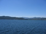
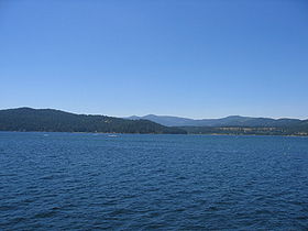
According to the 2000 census, the county has a total area of 1315.69 square miles (3,407.6 km²), of which 1245.12 square miles (3,224.8 km²) (or 94.64%) is land and 70.57 square miles (182.8 km²) (or 5.36%) is water. The vast majority of the water area is the county's primary attraction, Lake Coeur d'AleneLake Coeur d'Alene
Lake Coeur d'Alene is a natural lake in the Idaho Panhandle, located in the vicinity of the city of the same name. It spans long, ranges from 1 to wide and has over of shoreline for boaters and vacationers to explore and enjoy.-Geology and geography:...
. Kootenai County is part of the Inland Empire
Inland Empire (Pacific Northwest)
thumb|The Inland Empire regionThe Inland Northwest, or Inland Empire, is a region in the Pacific Northwest centered on Spokane, Washington, including the surrounding Columbia River basin and all of North Idaho....
in the Idaho Panhandle
Idaho Panhandle
The Idaho Panhandle is the northern region of the U.S. State of Idaho that encompasses the ten northernmost counties of Benewah, Bonner, Boundary, Clearwater, Idaho, Kootenai, Latah, Lewis, Nez Perce, Shoshone. Residents of the panhandle refer to the region as North Idaho...
.
Adjacent counties
- Bonner CountyBonner County, IdahoBonner County is a county located in the northern part of the U.S. state of Idaho. Established in 1907, it was named for Edwin L. Bonner, a ferry operator. As of the 2010 census, the county had a population of 40,877. The county seat and largest city is Sandpoint.-History:Bonner County was formed...
- north - Shoshone CountyShoshone County, IdahoShoshone County is a county located in the U.S. state of Idaho. The county was established in 1864, named for the Native American Shoshone tribe. The population was 12,765 at the 2010 census. Shoshone County is commonly referred to as the Silver Valley, due to its century-old mining history...
- east - Benewah CountyBenewah County, IdahoBenewah County is a county located in the U.S. state of Idaho. Established on January 23, 1915, from sections of Kootenai County, it was named for a chief of the Coeur d'Alene Tribe. As of the 2010 census the county had a population of 9,285. The county seat and largest city is St...
- south - Spokane CountySpokane County, WashingtonSpokane County is a county located in the U.S. state of Washington, named after the Spokane tribe. As of the 2010 census the population was 471,221, making it the fourth most populous county in Washington state. The largest city and county seat is Spokane, the second largest city in the state,...
, Washington - west
National protected areas
- Coeur d'Alene National ForestCoeur d'Alene National ForestThe Coeur d'Alene is a U.S. National Forest located in the Idaho panhandle and is one of three forests that are aggregated into the Idaho Panhandle National Forest . Coeur d'Alene National Forest is located in Shoshone, Kootenai, and Bonner counties in northern Idaho...
(part) - Kaniksu National ForestKaniksu National ForestThe Kaniksu National Forest is a U.S. National Forest located in northeastern Washington, the Idaho panhandle, and northwestern Montana. The Idaho portion is one of three forests that are aggregated into the Idaho Panhandle National Forest, along with the Coeur d'Alene National Forest and St. Joe...
(part)
Highways
 - Interstate 90Interstate 90 in IdahoIn the U.S. state of Idaho, Interstate 90 has a small routing in the panhandle, just under 74 miles . Traveling east from Spokane, Washington, I-90 passes through Post Falls and Coeur d'Alene, over Fourth of July Summit, and through the Silver Valley before entering Montana at Lookout Pass.I-90 is...
 - US 95U.S. Route 95 in IdahoIn the U.S. state of Idaho, U.S. Route 95 is a north–south highway near the western border of the state, stretching from Oregon to British Columbia for over .-Route description:...
 - SH-3Idaho State Highway 3Idaho State Highway 3 is a state highway in northern Idaho connecting US 12 near Spalding with I-90 near Rose Lake. It is long and runs north–south.-Route description:...
 - SH-41Idaho State Highway 41State Highway 41, abbreviated SH-41, is a state highway mostly in the U.S. state of Idaho. It runs from Interstate 90 in Post Falls to U.S. Route 2 on the Washington state line. The northernmost of SH-41 run along State Street along the state line, with the southbound lane in the town of...
 - SH-53Idaho State Highway 53State Highway 53 is a long state highway serving Kootenai County in the U.S. state of Idaho. SH-53 travels northeast from Washington State Route 290 at the Washington state border near Hauser to a short concurrency with SH-41 in Rathdrum. From Rathdrum, the highway continues east to end at U.S....
 - SH-54
 - SH-97
History
Kootenai County was formed on December 22, 1864, from the northern section of Nez Perce CountyNez Perce County, Idaho
Nez Perce County [Eng. pron. Nezz Purse] is a county located in the U.S. state of Idaho. The population was 39,265 at the 2010 Census. The county seat is Lewiston. The county is named for the Nez Percé tribe....
. It was named after the Kootenai
Kootenai (tribe)
The Ktunaxa , also known as Kootenai, Kutenai or Kootenay , are an indigenous people of North America. They are one of three tribes of the Confederated Salish and Kootenai Tribes of the Flathead Nation in Montana, and they form the Ktunaxa Nation in British Columbia...
, because it lies in the traditional area of settlement of the tribe.
Once comprising most of the western Panhandle
Idaho Panhandle
The Idaho Panhandle is the northern region of the U.S. State of Idaho that encompasses the ten northernmost counties of Benewah, Bonner, Boundary, Clearwater, Idaho, Kootenai, Latah, Lewis, Nez Perce, Shoshone. Residents of the panhandle refer to the region as North Idaho...
, the county's present boundaries were established in 1915, following the formation of Benewah County
Benewah County, Idaho
Benewah County is a county located in the U.S. state of Idaho. Established on January 23, 1915, from sections of Kootenai County, it was named for a chief of the Coeur d'Alene Tribe. As of the 2010 census the county had a population of 9,285. The county seat and largest city is St...
to the south.
Directly east of Kootenai County is Shoshone County
Shoshone County, Idaho
Shoshone County is a county located in the U.S. state of Idaho. The county was established in 1864, named for the Native American Shoshone tribe. The population was 12,765 at the 2010 census. Shoshone County is commonly referred to as the Silver Valley, due to its century-old mining history...
and the Silver Valley, which has had a history of disputes between miners and mine owners
Coeur d'Alene miners' dispute
There were two related incidents between miners and mine owners in the Coeur d'Alene Mining District of North Idaho: the Coeur d'Alene, Idaho labor strike of 1892, and the Coeur d'Alene, Idaho labor confrontation of 1899. This article is a brief overview of both events.The strike of 1892 had its...
.
Demographics
As of the censusCensus
A census is the procedure of systematically acquiring and recording information about the members of a given population. It is a regularly occurring and official count of a particular population. The term is used mostly in connection with national population and housing censuses; other common...
of 2000, there were 108,685 people, 41,308 households, and 29,659 families residing in the county. The population density
Population density
Population density is a measurement of population per unit area or unit volume. It is frequently applied to living organisms, and particularly to humans...
was 87 people per square mile (34/km²). There were 46,607 housing units at an average density of 37 per square mile (14/km²). The racial makeup of the county was 95.84% White
Race (United States Census)
Race and ethnicity in the United States Census, as defined by the Federal Office of Management and Budget and the United States Census Bureau, are self-identification data items in which residents choose the race or races with which they most closely identify, and indicate whether or not they are...
, 0.17% Black
Race (United States Census)
Race and ethnicity in the United States Census, as defined by the Federal Office of Management and Budget and the United States Census Bureau, are self-identification data items in which residents choose the race or races with which they most closely identify, and indicate whether or not they are...
or African American
Race (United States Census)
Race and ethnicity in the United States Census, as defined by the Federal Office of Management and Budget and the United States Census Bureau, are self-identification data items in which residents choose the race or races with which they most closely identify, and indicate whether or not they are...
, 1.23% Native American
Race (United States Census)
Race and ethnicity in the United States Census, as defined by the Federal Office of Management and Budget and the United States Census Bureau, are self-identification data items in which residents choose the race or races with which they most closely identify, and indicate whether or not they are...
, 0.50% Asian
Race (United States Census)
Race and ethnicity in the United States Census, as defined by the Federal Office of Management and Budget and the United States Census Bureau, are self-identification data items in which residents choose the race or races with which they most closely identify, and indicate whether or not they are...
, 0.07% Pacific Islander
Race (United States Census)
Race and ethnicity in the United States Census, as defined by the Federal Office of Management and Budget and the United States Census Bureau, are self-identification data items in which residents choose the race or races with which they most closely identify, and indicate whether or not they are...
, 0.59% from other races
Race (United States Census)
Race and ethnicity in the United States Census, as defined by the Federal Office of Management and Budget and the United States Census Bureau, are self-identification data items in which residents choose the race or races with which they most closely identify, and indicate whether or not they are...
, and 1.60% from two or more races. 2.33% of the population were Hispanic
Race (United States Census)
Race and ethnicity in the United States Census, as defined by the Federal Office of Management and Budget and the United States Census Bureau, are self-identification data items in which residents choose the race or races with which they most closely identify, and indicate whether or not they are...
or Latino
Race (United States Census)
Race and ethnicity in the United States Census, as defined by the Federal Office of Management and Budget and the United States Census Bureau, are self-identification data items in which residents choose the race or races with which they most closely identify, and indicate whether or not they are...
of any race. 23.2% were of German
Germans
The Germans are a Germanic ethnic group native to Central Europe. The English term Germans has referred to the German-speaking population of the Holy Roman Empire since the Late Middle Ages....
, 11.9% English
English people
The English are a nation and ethnic group native to England, who speak English. The English identity is of early mediaeval origin, when they were known in Old English as the Anglecynn. England is now a country of the United Kingdom, and the majority of English people in England are British Citizens...
, 10.9% Irish
Irish people
The Irish people are an ethnic group who originate in Ireland, an island in northwestern Europe. Ireland has been populated for around 9,000 years , with the Irish people's earliest ancestors recorded having legends of being descended from groups such as the Nemedians, Fomorians, Fir Bolg, Tuatha...
, 9.4% American
United States
The United States of America is a federal constitutional republic comprising fifty states and a federal district...
and 6.1% Norwegian ancestry according to Census 2000. 96.6% spoke English
English language
English is a West Germanic language that arose in the Anglo-Saxon kingdoms of England and spread into what was to become south-east Scotland under the influence of the Anglian medieval kingdom of Northumbria...
and 1.7% Spanish
Spanish language
Spanish , also known as Castilian , is a Romance language in the Ibero-Romance group that evolved from several languages and dialects in central-northern Iberia around the 9th century and gradually spread with the expansion of the Kingdom of Castile into central and southern Iberia during the...
as their first language.
There were 41,308 households out of which 34.90% had children under the age of 18 living with them, 58.60% were married couples
Marriage
Marriage is a social union or legal contract between people that creates kinship. It is an institution in which interpersonal relationships, usually intimate and sexual, are acknowledged in a variety of ways, depending on the culture or subculture in which it is found...
living together, 9.20% had a female householder with no husband present, and 28.20% were non-families. 21.90% of all households were made up of individuals and 8.30% had someone living alone who was 65 years of age or older. The average household size was 2.60 and the average family size was 3.03.
In the county the population was spread out with 27.10% under the age of 18, 8.70% from 18 to 24, 28.00% from 25 to 44, 23.90% from 45 to 64, and 12.30% who were 65 years of age or older. The median age was 36 years. For every 100 females there were 98.10 males. For every 100 females age 18 and over, there were 94.90 males.
The median income for a household in the county was $37,754, and the median income for a family was $42,905. Males had a median income of $33,661 versus $22,113 for females. The per capita income
Per capita income
Per capita income or income per person is a measure of mean income within an economic aggregate, such as a country or city. It is calculated by taking a measure of all sources of income in the aggregate and dividing it by the total population...
for the county was $18,430. About 7.70% of families and 10.50% of the population were below the poverty line, including 12.90% of those under age 18 and 7.30% of those age 65 or over.
Cities
|
Hayden Lake, Idaho Hayden Lake is a both a city and a lake in Kootenai County, Idaho, United States. Hayden Lake is one of several natural lakes in northern Idaho... Huetter, Idaho Huetter is a city in Kootenai County, Idaho, United States. The population was 96 at the 2000 census.-Geography:Huetter is located at .According to the United States Census Bureau, the city has a total area of , all of it land.... Post Falls, Idaho Post Falls is a city in Kootenai County, Idaho, United States near the Idaho state line between Spokane, Washington, and Coeur d'Alene, Idaho. The population was 17,247 at the 2000 census, and grew to 27,574 people by the 2010 census, making it Idaho's tenth largest city.-History:Post Falls is... Rathdrum, Idaho Rathdrum is a city in Kootenai County, Idaho, United States. The population was 6,826 at the 2010 census.-Geography:Rathdrum is located at .... Spirit Lake, Idaho Spirit Lake is a city in Kootenai County, Idaho, United States. The population was 1,945 at the 2010 census.-Geography:Spirit Lake is located at .According to the United States Census Bureau, the city has a total area of , all of it land.-Demographics:... State Line, Idaho State Line is a city in Kootenai County, Idaho, United States. The population was 28 at the 2000 census. The city is known for the adult services it provides which attracts business from nearby Spokane, Washington and Coeur d'Alene, Idaho.-Geography:... Worley, Idaho Worley is a city in southwestern Kootenai County, Idaho, United States. The population was 223 at the 2000 census. The city is within the Coeur d'Alene Indian Reservation.-Geography:... |
Unincorporated communities
- BayviewBayview, IdahoBayview is an unincorporated community in Kootenai County, Idaho, United States. Bayview is located on the southwest shore of Lake Pend Oreille east-northeast of Athol. The community is served by Idaho State Highway 54. Bayview has a post office with ZIP code 83803....
- CataldoCataldo, IdahoCataldo is an unincorporated community in Kootenai and Shoshone counties in the U.S. state of Idaho. It is located at , at an altitude of 2,139 feet ....
- GarwoodGarwood, IdahoGarwood is a small unincorporated community in northern Kootenai County, Idaho, United States. It consists of several ranch houses....