
Knin Fortress
Encyclopedia
Knin Fortress is a partially ruined fortress located just above Knin
, Croatia
. It is one of the biggest and most significant defensive strongholds, and a historical town in the Šibenik-Knin county
in the Dalmatia
n hinterland. The construction of the fortress started as early as 9th century, while the current state was brought up in 17th and 18th centuries. It reached its peak during the reign of Demetrius Zvonimir, King of Croatia from 1076, as it served as a political centre of the Croatian Kingdom
under him.
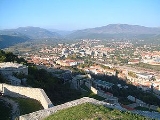
to continental Croatia and Bosnia. The Knin Fortress lies on top of the steep Spas mountain, just 328 feet above the Croatian town of Knin
, whose historical location was formed quite early at the foothills of the same mountain. Archaeological excavations date that this area was populated since the 6th century. It is 470 meters long, and 110 meters wide, elevated on 345 meters above the sea.
The original look of the building, because of the lack of its material, isn't completely known. According to other similar fortifications from that time, it is assumed that it was surrounded by high walls, while the construction was accommodated to the terrain; it is environmentally secured by steep slopes on some places.
The fortress is comprised by three parts: northern, middle and southern. Each part of the fortress is protected by loophole
s and gun holes, and is connected to other parts by the city gates and drawbridge
s. The formation of the northern section, according to recent research, happened from the middle of 8th century to the end of 11th century.
A Baroque stone gates are set on the main entrance to the fortress, where the doors are made out of oakwood
and strengthened with iron nails. This monumental entrance was most likely constructed by Ignacije Macanović, a builder from Trogir. Above the doors, the simbol of the Venetian Republic can be seen.
Towards the northern part, on the left side, a building of the governor of arms used to be there; today it is the old city hall. Left to it were the barracks which eventually became the gallery of the museum of Knin. On the same location a memorial was elevated to fra Lujo Marun (1857 - 1939), a friar who was the first to instigate archaeological excavations in this area, and to discover many remains of the old Croatian culture.
Within the church of St. Barbara, a bell is kept as a gift from pope John Paul II, which was given to Knin during his stay in 1994.
The current state was undertaken by a Venetian military engineer, Alberghetti, where an inscription suggests that the construction works were completed in 1711. It is protected as a historical urban complex and is inscribed in the register of the Cultural heritage of Croatia as a monument of top importance.
The church of St. Barbra, dedicated to Cyril and Methodius, also holds an 10th century epitaph
written in Old Church Slavonic
:
built the fortress near a devastated Roman settlement (Latin
: Tignino castro), soon after they settled in the area. Its guardians continuously upgraded the structure to accommodate the defensive needs at that time. It was one of the residences of Croatian monarchs, and possibly became the main residence later, since it was much safer to rule from Knin over the lands of Liburnia
and Dalmatia
, and to Christianize the pagan Croats in Gacka
, Lika
and Krbava
. This is testified by a handful of churches in the Knin area built in the time of Prince Trpimir.
The fortress contained few ceremonial halls and the palace of the Croatian rulers, in which they issued their documents and lived with their courtiers during their stay in Knin. On the other more raised plateau
of the mountain Spas, south from the fortress Tnena, a second, smaller fortification was built; the Citadel Lab (Latin
: castro Lab, Labwar) which was the seat of the viceban
.
The diocese of Knin was established in 1040 by King Stephen I of Croatia, which spanned the area to the river Drava
. The bishop of Knin had also the nominal title as the "Croatian bishop".
The fortress was divided to a small and a big town in the 14th century. The small town was used primarily for defensive reasons, while the big town comprised the flats that were occupied by the town's governors, bishop
s or župan
s. Suburbs were located just outside the walls. The oldest section is the upper town on the northern side of the fortress, while the middle and lower towns were built in the Late Middle Ages
.
It is possible that, in the 15th century, during the raising danger of the Ottoman advance towards Europe
, an additional railing defensive wall was constructed on which the main entrance to the fortress is situated today. Both of these fortifications, citadels, were connected in a unified defensive complex.
The oldest known graphical presentation of Knin was recorded on a map of northern Dalmatia and Lika
by a Venetian cartographer, Matteo Pagano (1515-1588), in about 1525. However, the more detailed description of the urban appearance of the fortification was handed by another Venetian, the military engineer named Orazio Antonio Alberghetti (1656-1690) in one of his schemes made in the time of the expulsion of the Turks in 1688.
Knin
Knin is a historical town in the Šibenik-Knin county of Croatia, located near the source of the river Krka at , in the Dalmatian hinterland, on the railroad Zagreb–Split. Knin rose to prominence twice in history, as a one-time capital of both the Kingdom of Croatia and briefly of the...
, Croatia
Croatia
Croatia , officially the Republic of Croatia , is a unitary democratic parliamentary republic in Europe at the crossroads of the Mitteleuropa, the Balkans, and the Mediterranean. Its capital and largest city is Zagreb. The country is divided into 20 counties and the city of Zagreb. Croatia covers ...
. It is one of the biggest and most significant defensive strongholds, and a historical town in the Šibenik-Knin county
Šibenik-Knin County
Šibenik-Knin County is a county in Croatia, located in north-central Dalmatia. Its center is Šibenik; other notable towns are Knin, Drniš and Skradin....
in the Dalmatia
Dalmatia
Dalmatia is a historical region on the eastern coast of the Adriatic Sea. It stretches from the island of Rab in the northwest to the Bay of Kotor in the southeast. The hinterland, the Dalmatian Zagora, ranges from fifty kilometers in width in the north to just a few kilometers in the south....
n hinterland. The construction of the fortress started as early as 9th century, while the current state was brought up in 17th and 18th centuries. It reached its peak during the reign of Demetrius Zvonimir, King of Croatia from 1076, as it served as a political centre of the Croatian Kingdom
Kingdom of Croatia (medieval)
The Kingdom of Croatia , also known as the Kingdom of the Croats , was a medieval kingdom covering most of what is today Croatia and Bosnia and Herzegovina in the Balkans.Established in 925, it ruled as a sovereign state for almost two centuries...
under him.
Location and description
It is situated on the main transport corridor leading from DalmatiaDalmatia
Dalmatia is a historical region on the eastern coast of the Adriatic Sea. It stretches from the island of Rab in the northwest to the Bay of Kotor in the southeast. The hinterland, the Dalmatian Zagora, ranges from fifty kilometers in width in the north to just a few kilometers in the south....
to continental Croatia and Bosnia. The Knin Fortress lies on top of the steep Spas mountain, just 328 feet above the Croatian town of Knin
Knin
Knin is a historical town in the Šibenik-Knin county of Croatia, located near the source of the river Krka at , in the Dalmatian hinterland, on the railroad Zagreb–Split. Knin rose to prominence twice in history, as a one-time capital of both the Kingdom of Croatia and briefly of the...
, whose historical location was formed quite early at the foothills of the same mountain. Archaeological excavations date that this area was populated since the 6th century. It is 470 meters long, and 110 meters wide, elevated on 345 meters above the sea.
The original look of the building, because of the lack of its material, isn't completely known. According to other similar fortifications from that time, it is assumed that it was surrounded by high walls, while the construction was accommodated to the terrain; it is environmentally secured by steep slopes on some places.
The fortress is comprised by three parts: northern, middle and southern. Each part of the fortress is protected by loophole
Loophole
A loophole is a weakness that allows a system to be circumvented.Loophole may also refer to:*Arrowslit, a slit in a castle wall*Loophole , a short science fiction story by Arthur C...
s and gun holes, and is connected to other parts by the city gates and drawbridge
Drawbridge
A drawbridge is a type of movable bridge typically associated with the entrance of a castle surrounded by a moat. The term is often used to describe all different types of movable bridges, like bascule bridges and lift bridges.-Castle drawbridges:...
s. The formation of the northern section, according to recent research, happened from the middle of 8th century to the end of 11th century.
A Baroque stone gates are set on the main entrance to the fortress, where the doors are made out of oakwood
Oakwood
-Places:in Canada*Oakwood, Ontario*Oakwood-Vaughan, Toronto, Ontario, a neighbourhood**Oakwood Collegiate Institute, a public high school in the southern end of the Oakwood-Vaughan neighbourhoodin the United Kingdom...
and strengthened with iron nails. This monumental entrance was most likely constructed by Ignacije Macanović, a builder from Trogir. Above the doors, the simbol of the Venetian Republic can be seen.
Towards the northern part, on the left side, a building of the governor of arms used to be there; today it is the old city hall. Left to it were the barracks which eventually became the gallery of the museum of Knin. On the same location a memorial was elevated to fra Lujo Marun (1857 - 1939), a friar who was the first to instigate archaeological excavations in this area, and to discover many remains of the old Croatian culture.
Within the church of St. Barbara, a bell is kept as a gift from pope John Paul II, which was given to Knin during his stay in 1994.
The current state was undertaken by a Venetian military engineer, Alberghetti, where an inscription suggests that the construction works were completed in 1711. It is protected as a historical urban complex and is inscribed in the register of the Cultural heritage of Croatia as a monument of top importance.
The church of St. Barbra, dedicated to Cyril and Methodius, also holds an 10th century epitaph
Epitaph
An epitaph is a short text honoring a deceased person, strictly speaking that is inscribed on their tombstone or plaque, but also used figuratively. Some are specified by the dead person beforehand, others chosen by those responsible for the burial...
written in Old Church Slavonic
Old Church Slavonic
Old Church Slavonic or Old Church Slavic was the first literary Slavic language, first developed by the 9th century Byzantine Greek missionaries Saints Cyril and Methodius who were credited with standardizing the language and using it for translating the Bible and other Ancient Greek...
:
History
The CroatsCroats
Croats are a South Slavic ethnic group mostly living in Croatia, Bosnia and Herzegovina and nearby countries. There are around 4 million Croats living inside Croatia and up to 4.5 million throughout the rest of the world. Responding to political, social and economic pressure, many Croats have...
built the fortress near a devastated Roman settlement (Latin
Latin
Latin is an Italic language originally spoken in Latium and Ancient Rome. It, along with most European languages, is a descendant of the ancient Proto-Indo-European language. Although it is considered a dead language, a number of scholars and members of the Christian clergy speak it fluently, and...
: Tignino castro), soon after they settled in the area. Its guardians continuously upgraded the structure to accommodate the defensive needs at that time. It was one of the residences of Croatian monarchs, and possibly became the main residence later, since it was much safer to rule from Knin over the lands of Liburnia
Liburnia
Liburnia in ancient geography was the land of the Liburnians, a region along the northeastern Adriatic coast in Europe, in modern Croatia, whose borders shifted according to the extent of Liburnian dominance at a given time between 11th and 1st century BC...
and Dalmatia
Dalmatia
Dalmatia is a historical region on the eastern coast of the Adriatic Sea. It stretches from the island of Rab in the northwest to the Bay of Kotor in the southeast. The hinterland, the Dalmatian Zagora, ranges from fifty kilometers in width in the north to just a few kilometers in the south....
, and to Christianize the pagan Croats in Gacka
Gacka
Gacka is a river located in the Lika region in central Croatia. Because for a large part of its course it is a subterranean river, estimates on its length vary. The overground part has undergone substantial human intervention - before it was 32 kilometers long, now it is only 11 km...
, Lika
Lika
Lika is a mountainous region in central Croatia, roughly bound by the Velebit mountain from the southwest and the Plješevica mountain from the northeast. On the north-west end Lika is bounded by Ogulin-Plaški basin, and on the south-east by the Malovan pass...
and Krbava
Krbava
Krbava is a region of mountainous Croatia. It can be considered either located east of Lika, or indeed as the eastern part of Lika. The town of Udbina is the central settlement of the Krbava karst field....
. This is testified by a handful of churches in the Knin area built in the time of Prince Trpimir.
The fortress contained few ceremonial halls and the palace of the Croatian rulers, in which they issued their documents and lived with their courtiers during their stay in Knin. On the other more raised plateau
Plateau
In geology and earth science, a plateau , also called a high plain or tableland, is an area of highland, usually consisting of relatively flat terrain. A highly eroded plateau is called a dissected plateau...
of the mountain Spas, south from the fortress Tnena, a second, smaller fortification was built; the Citadel Lab (Latin
Latin
Latin is an Italic language originally spoken in Latium and Ancient Rome. It, along with most European languages, is a descendant of the ancient Proto-Indo-European language. Although it is considered a dead language, a number of scholars and members of the Christian clergy speak it fluently, and...
: castro Lab, Labwar) which was the seat of the viceban
Ban (title)
Ban was a title used in several states in central and south-eastern Europe between the 7th century and the 20th century.-Etymology:The word ban has entered the English language probably as a borrowing from South Slavic ban, meaning "lord, master; ruler". The Slavic word is probably borrowed from...
.
The diocese of Knin was established in 1040 by King Stephen I of Croatia, which spanned the area to the river Drava
Drava
Drava or Drave is a river in southern Central Europe, a tributary of the Danube. It sources in Toblach/Dobbiaco, Italy, and flows east through East Tirol and Carinthia in Austria, into Slovenia , and then southeast, passing through Croatia and forming most of the border between Croatia and...
. The bishop of Knin had also the nominal title as the "Croatian bishop".
The fortress was divided to a small and a big town in the 14th century. The small town was used primarily for defensive reasons, while the big town comprised the flats that were occupied by the town's governors, bishop
Bishop
A bishop is an ordained or consecrated member of the Christian clergy who is generally entrusted with a position of authority and oversight. Within the Catholic Church, Eastern Orthodox, Oriental Orthodox Churches, in the Assyrian Church of the East, in the Independent Catholic Churches, and in the...
s or župan
Zupan
Żupan was a long garment, always lined, worn by almost all males of the noble social class in the Polish-Lithuanian Commonwealth, typical male attire from the beginning of the 16th to half of the 18th century, still surviving as a part of the Polishnational dress.- Derivation :The name żupan has...
s. Suburbs were located just outside the walls. The oldest section is the upper town on the northern side of the fortress, while the middle and lower towns were built in the Late Middle Ages
Late Middle Ages
The Late Middle Ages was the period of European history generally comprising the 14th to the 16th century . The Late Middle Ages followed the High Middle Ages and preceded the onset of the early modern era ....
.
It is possible that, in the 15th century, during the raising danger of the Ottoman advance towards Europe
Ottoman wars in Europe
The wars of the Ottoman Empire in Europe are also sometimes referred to as the Ottoman Wars or as Turkish Wars, particularly in older, European texts.- Rise :...
, an additional railing defensive wall was constructed on which the main entrance to the fortress is situated today. Both of these fortifications, citadels, were connected in a unified defensive complex.
The oldest known graphical presentation of Knin was recorded on a map of northern Dalmatia and Lika
Lika
Lika is a mountainous region in central Croatia, roughly bound by the Velebit mountain from the southwest and the Plješevica mountain from the northeast. On the north-west end Lika is bounded by Ogulin-Plaški basin, and on the south-east by the Malovan pass...
by a Venetian cartographer, Matteo Pagano (1515-1588), in about 1525. However, the more detailed description of the urban appearance of the fortification was handed by another Venetian, the military engineer named Orazio Antonio Alberghetti (1656-1690) in one of his schemes made in the time of the expulsion of the Turks in 1688.