

King Street, Hamilton, Ontario
Encyclopedia
King Street is a Lower City arterial road in Hamilton, Ontario
, Canada
, also known as Highway 8. The western-end starts off in front of the McMaster Medical Centre as a two-way street and passes through Westdale
and then at Paradise Road South, King Street switches over to a one-way street (Westbound) right through the city's core up to the Delta, a spot in town where King and Main Streets
intersect. (West of the Delta, King Street is North of Main Street. East of the Delta after King crosses over Main Street, King then runs South of Main Street.) From the Delta onwards King Street then switches over to become a two-way street again and ends at Queenston Road
in Stoney Creek
.
Note: Queenston Road, runs parallel with King Street, then King Street flows northward where it connects and ends at Queenston Road.
King Street follows the path of an old Indian Trail
and was named after King George III.
In 1815, George Hamilton
, a settler and local politician, established a town site in the northern portion Barton Township after the war in 1815. He kept several east-west roads which were originally Indian trails, but the north-south streets were on a regular grid pattern. Streets were designated "East" or "West" if they crossed James Street
or Highway 6. Streets were designated "North" or "South" if they crossed King Street or Highway 8.
In 1860, Edward, Prince of Wales (who later became King Edward VII) was in Hamilton to open up Gore Park (town centre) and the Crystal Palace. The Crystal Palace saw various Agricultural Exhibitions. It was modeled on the famous Crystal Palace designed and built in London, England. By 1891 the structure was in bad condition and decision was made to demolish it. All traces disappeared from the site which is now known as Victoria Park.
On 30 October 1893, The Sir John A. Macdonald
Statue arrives in Hamilton from London, England. Official dedication of the statue took place 1 November 1893. Located at the intersection of King and Hughson Streets
. Prime Minister Sir John Thompson in attendance.
The Pantages Theatre opened up in 1921 on King Street, (between Catharine Street
and Mary Street), with a seating capacity
of 3,500 made it the largest theatre in Canada at the time. In 1930 it was renamed The Palace Theatre. It closed down in 1972. Hamilton one time was home to many Grand Theatres, all of which are no longer in existence. These include, Grand Opera House (James Street North
), Savoy Theatre (Merrick Street), Temple Theatre (behind the Terminal Building on King Street), Lyric Theatre (Mary Street) and The Loews Theatre renamed later to The Capitol (King Street East).
The Cenotaph
at Veteran's Place at Gore Park was enveiled on May 22, 1923 by Governor General Viscount Byng
who led Canadians into France
and Flanders
. The Cenotaph commemorates the 53,000 Canadian soldiers, 2,000 of them Hamiltonians, who were killed during the first World War
. Hamilton's Cenotaph is a replica of the British
Cenotaph in Westminster, London and was designed by William Russell Souter (1894–1971), a Hamilton architect
, and World War I veteran. It consists of a huge granite column with an image of a casket
at its summit. Two smaller columns are at its side with carved replicas of the equipment used by Canadian troop
s in the First World War.
In 1925, The first traffic lights in Canada went into operation at the Delta. (11 June 1925).
McMaster University
moved to Hamilton, Ontario
from Toronto in 1930, thanks to the efforts of Thomas McQuesten
.
Christ the King Cathedral, is a Roman Catholic church in Hamilton, Ontario
Canada
. The Cathedral was consecrated on December 19, 1933. The cathedral is perched atop a hill overlooking Highway 403
leading in towards the rest of Hamilton and one travelling towards Oakville, Missisauga and Toronto.
CHCH-TV 11 began broadcasting in 1954 as a CBC
affiliate from a studio on King Street West (close to Victoria Park) and a transmitter located at 481 First Road West in Stoney Creek
. At the time, all private stations were required to be CBC affiliates. Then in 1961, CHCH disaffiliated from the CBC and became an independent TV station. CHCH-TV 11 studios are now at the corner of Jackson Street West
and Caroline Streets. The old studio building on King Street West is now the Westside Concert Theatre.
In 1966, Terminal Towers including a new eight-storey Holiday Inn
opened on the site of the old transit terminal between King and Main
at Catharine Street
. It's now called Effort Square and the hotel is a Ramada Plaza Hotel.
(mall) was completed, including Stelco Tower
and Bank of Montreal Pavilion in 1972. Then in 1977, the second phase of Jackson Square was completed with a six-storey office tower, but not the department store intended to be its major attraction. Also in 1977, The Art Gallery of Hamilton
opened beside the Board of Education building. In 1981, The Hamilton Convention Centre and the government office tower above it opened. The tower was named the Ellen Fairclough Building
one year later in 1982. In 1983, the Standard Life Centre opened at the west end of Jackson Square. In 1985, Sheraton Hamilton
, connected to Jackson Square, opened, boosting downtown Hamilton's hotel space. In 1985, Copps Coliseum
, sports and entertainment arena with a capacity of up to 19,000 (depending on event type and configuration) opens its doors for business (one block North of King Street at Bay Street
). It's named after the former Hamilton mayor, Victor K. Copps. In 1987, the first of two reflective glass buildings of the CIBC tower (Commerce Place I
) opened at King and James opposite Gore Park. The other (Commerce Place II
) opened in 1990.
, which made it a major tourist destination. The Festival of Friends, founded in 1975, is the largest annual free music event in the country. Burton Cummings
, Lighthouse and Bruce Cockburn
have been among the main stage headliners at Gage Park on Gage Avenue
. WestJet
is a major sponsor of the festival. Hamilton is also home to the Mustard Festivalhttp://www.hamiltoninternationalvillage.ca/index.asp because Hamilton is home to the largest miller of dry mustard in the world. It's held annually at Ferguson Station, Ferguson Avenue
and King Street East at Hamilton's International Village and is another summertime food & beverage festival that features some of the top Blues and Jazz acts in the region.
In 2001, the Steven Seagal
film Exit Wounds
used the streets of Downtown Hamilton for a period of 6-weeks during a night shoot of the movie's climatic chase scene that features the Gore Park water fountain and the Hamilton GO Transit station, Original site of the Toronto, Hamilton and Buffalo Railway
(1892–1987).
. It has a seasonal schedule that runs weekends from May-to-October connecting Hamilton's downtown core to the waterfront and attractions that can be found there like HMCS Haida and the Parks Canada Discovery Centre. The route circles Hamilton's downtown core around York Boulevard
(north), Bay Street South
(west), King Street West (south) and James Street North
(east). Then it travels north along James Street and the Art District until it reaches the waterfront at Guise Street past the Royal Hamilton Yacht Club
, Hamilton Chamber of Commerce and the Harbour West Marina Complex. Then the route hangs a left on Discovery Drive, the site of the Parks Canada Discovery Centre. Also at this site is the Hamilton Harbour Queen (cruise boat), Hamiltonian (tour boat) and the Hamilton Waterfront Trolley.
Hamilton, Ontario
Hamilton is a port city in the Canadian province of Ontario. Conceived by George Hamilton when he purchased the Durand farm shortly after the War of 1812, Hamilton has become the centre of a densely populated and industrialized region at the west end of Lake Ontario known as the Golden Horseshoe...
, Canada
Canada
Canada is a North American country consisting of ten provinces and three territories. Located in the northern part of the continent, it extends from the Atlantic Ocean in the east to the Pacific Ocean in the west, and northward into the Arctic Ocean...
, also known as Highway 8. The western-end starts off in front of the McMaster Medical Centre as a two-way street and passes through Westdale
Westdale, Ontario
Westdale is a residential neighbourhood in Hamilton, Ontario, Canada. It is centred on the Westdale Village shopping district and located near McMaster University. Westdale has been the heart of the Jewish community of Hamilton for many years...
and then at Paradise Road South, King Street switches over to a one-way street (Westbound) right through the city's core up to the Delta, a spot in town where King and Main Streets
Main Street (Hamilton, Ontario)
Main Street, is a Lower City arterial road in Hamilton, Ontario, Canada. It starts east of Wilson Street in Ancaster at White Chapel Cemetery as a two-way street and switches over to a one-way street at Paradise Road South, in Westdale, where it continues up to the Delta where it once again...
intersect. (West of the Delta, King Street is North of Main Street. East of the Delta after King crosses over Main Street, King then runs South of Main Street.) From the Delta onwards King Street then switches over to become a two-way street again and ends at Queenston Road
Queenston Road (Hamilton, Ontario)
Queenston Road is a two-way Lower City arterial road in Hamilton, Ontario, Canada. Also known as Highway 8. It starts off at the Queenston Traffic Circle and travels eastward over the Red Hill Valley Parkway and into Stoney Creek past the Fruitland and Winona communities and into Niagara Region as...
in Stoney Creek
Stoney Creek, Ontario
Stoney Creek is a community in Ontario, Canada.Note: This article will only deal with matters up to its amalgamation with Hamilton.-Geography and population:...
.
Note: Queenston Road, runs parallel with King Street, then King Street flows northward where it connects and ends at Queenston Road.
History
King Street follows the path of an old Indian Trail
Indian Trail
Indian Trail can refer to:*A part of or the whole of the Great Trail created by Native Americans*Indian Trail, North Carolina*A junior high in Olathe, Kansas -- Indian Trail Junior High...
and was named after King George III.
In 1815, George Hamilton
George Hamilton (politician)
George Hamilton was a Canadian merchant and politician, who founded the city of Hamilton, Ontario.Hamiliton was born on October 1788 in Queenston Heights...
, a settler and local politician, established a town site in the northern portion Barton Township after the war in 1815. He kept several east-west roads which were originally Indian trails, but the north-south streets were on a regular grid pattern. Streets were designated "East" or "West" if they crossed James Street
James Street (Hamilton, Ontario)
James Street is a Lower City arterial road in Hamilton, Ontario, Canada. It starts off at the base of the Niagara Escarpment from James Mountain Road, a mountain-access road in the city, originally was a one-way street going south throughout but now has sections of it that are two-way...
or Highway 6. Streets were designated "North" or "South" if they crossed King Street or Highway 8.
In 1860, Edward, Prince of Wales (who later became King Edward VII) was in Hamilton to open up Gore Park (town centre) and the Crystal Palace. The Crystal Palace saw various Agricultural Exhibitions. It was modeled on the famous Crystal Palace designed and built in London, England. By 1891 the structure was in bad condition and decision was made to demolish it. All traces disappeared from the site which is now known as Victoria Park.
On 30 October 1893, The Sir John A. Macdonald
John A. Macdonald
Sir John Alexander Macdonald, GCB, KCMG, PC, PC , QC was the first Prime Minister of Canada. The dominant figure of Canadian Confederation, his political career spanned almost half a century...
Statue arrives in Hamilton from London, England. Official dedication of the statue took place 1 November 1893. Located at the intersection of King and Hughson Streets
Hughson Street (Hamilton, Ontario)
Hughson Street is a Lower City collector road in Hamilton, Ontario, Canada. It starts at Charlton Avenue East at St. Joseph's hospital and runs north to Haymarket Street in the downtown where it's cut off by the Hamilton GO Transit station. Up to this point it is a two-way street...
. Prime Minister Sir John Thompson in attendance.
The Pantages Theatre opened up in 1921 on King Street, (between Catharine Street
Catharine Street (Hamilton, Ontario)
Catharine Street, is a Lower City collector road in Hamilton, Ontario, Canada. It starts off at Charlton Avenue East at Woolverton Park in the Corktown neighbourhood as a one-way street , tunnels underneath the Hunter Street Railway bridge and stretches up to Barton Street East where it then turns...
and Mary Street), with a seating capacity
Seating capacity
Seating capacity refers to the number of people who can be seated in a specific space, both in terms of the physical space available, and in terms of limitations set by law. Seating capacity can be used in the description of anything ranging from an automobile that seats two to a stadium that seats...
of 3,500 made it the largest theatre in Canada at the time. In 1930 it was renamed The Palace Theatre. It closed down in 1972. Hamilton one time was home to many Grand Theatres, all of which are no longer in existence. These include, Grand Opera House (James Street North
James Street (Hamilton, Ontario)
James Street is a Lower City arterial road in Hamilton, Ontario, Canada. It starts off at the base of the Niagara Escarpment from James Mountain Road, a mountain-access road in the city, originally was a one-way street going south throughout but now has sections of it that are two-way...
), Savoy Theatre (Merrick Street), Temple Theatre (behind the Terminal Building on King Street), Lyric Theatre (Mary Street) and The Loews Theatre renamed later to The Capitol (King Street East).
The Cenotaph
Cenotaph
A cenotaph is an "empty tomb" or a monument erected in honour of a person or group of people whose remains are elsewhere. It can also be the initial tomb for a person who has since been interred elsewhere. The word derives from the Greek κενοτάφιον = kenotaphion...
at Veteran's Place at Gore Park was enveiled on May 22, 1923 by Governor General Viscount Byng
Julian Byng, 1st Viscount Byng of Vimy
Field Marshal Julian Hedworth George Byng, 1st Viscount Byng of Vimy was a British Army officer who served as Governor General of Canada, the 12th since Canadian Confederation....
who led Canadians into France
France
The French Republic , The French Republic , The French Republic , (commonly known as France , is a unitary semi-presidential republic in Western Europe with several overseas territories and islands located on other continents and in the Indian, Pacific, and Atlantic oceans. Metropolitan France...
and Flanders
Flanders
Flanders is the community of the Flemings but also one of the institutions in Belgium, and a geographical region located in parts of present-day Belgium, France and the Netherlands. "Flanders" can also refer to the northern part of Belgium that contains Brussels, Bruges, Ghent and Antwerp...
. The Cenotaph commemorates the 53,000 Canadian soldiers, 2,000 of them Hamiltonians, who were killed during the first World War
World War I
World War I , which was predominantly called the World War or the Great War from its occurrence until 1939, and the First World War or World War I thereafter, was a major war centred in Europe that began on 28 July 1914 and lasted until 11 November 1918...
. Hamilton's Cenotaph is a replica of the British
United Kingdom
The United Kingdom of Great Britain and Northern IrelandIn the United Kingdom and Dependencies, other languages have been officially recognised as legitimate autochthonous languages under the European Charter for Regional or Minority Languages...
Cenotaph in Westminster, London and was designed by William Russell Souter (1894–1971), a Hamilton architect
Architect
An architect is a person trained in the planning, design and oversight of the construction of buildings. To practice architecture means to offer or render services in connection with the design and construction of a building, or group of buildings and the space within the site surrounding the...
, and World War I veteran. It consists of a huge granite column with an image of a casket
Coffin
A coffin is a funerary box used in the display and containment of dead people – either for burial or cremation.Contemporary North American English makes a distinction between "coffin", which is generally understood to denote a funerary box having six sides in plan view, and "casket", which...
at its summit. Two smaller columns are at its side with carved replicas of the equipment used by Canadian troop
Troop
A troop is a military unit, originally a small force of cavalry, subordinate to a squadron and headed by the troop leader. In many armies a troop is the equivalent unit to the infantry section or platoon...
s in the First World War.
In 1925, The first traffic lights in Canada went into operation at the Delta. (11 June 1925).
McMaster University
McMaster University
McMaster University is a public research university whose main campus is located in Hamilton, Ontario, Canada. The main campus is located on of land in the residential neighbourhood of Westdale, adjacent to Hamilton's Royal Botanical Gardens...
moved to Hamilton, Ontario
Hamilton, Ontario
Hamilton is a port city in the Canadian province of Ontario. Conceived by George Hamilton when he purchased the Durand farm shortly after the War of 1812, Hamilton has become the centre of a densely populated and industrialized region at the west end of Lake Ontario known as the Golden Horseshoe...
from Toronto in 1930, thanks to the efforts of Thomas McQuesten
Thomas McQuesten
Thomas Baker McQuesten was a Canadian athlete, militiaman, lawyer, politician and government appointee who lived in Hamilton, Ontario....
.
Christ the King Cathedral, is a Roman Catholic church in Hamilton, Ontario
Hamilton, Ontario
Hamilton is a port city in the Canadian province of Ontario. Conceived by George Hamilton when he purchased the Durand farm shortly after the War of 1812, Hamilton has become the centre of a densely populated and industrialized region at the west end of Lake Ontario known as the Golden Horseshoe...
Canada
Canada
Canada is a North American country consisting of ten provinces and three territories. Located in the northern part of the continent, it extends from the Atlantic Ocean in the east to the Pacific Ocean in the west, and northward into the Arctic Ocean...
. The Cathedral was consecrated on December 19, 1933. The cathedral is perched atop a hill overlooking Highway 403
Highway 403 (Ontario)
King's Highway 403, also known as Highway 403, is a 400-series highway in the Canadian province of Ontario that travels between Woodstock and Mississauga, branching off from and reuniting with Highway 401 at both ends and travelling south of it through Hamilton and Mississauga. It is concurrent...
leading in towards the rest of Hamilton and one travelling towards Oakville, Missisauga and Toronto.
CHCH-TV 11 began broadcasting in 1954 as a CBC
Canadian Broadcasting Corporation
The Canadian Broadcasting Corporation, commonly known as CBC and officially as CBC/Radio-Canada, is a Canadian crown corporation that serves as the national public radio and television broadcaster...
affiliate from a studio on King Street West (close to Victoria Park) and a transmitter located at 481 First Road West in Stoney Creek
Stoney Creek, Ontario
Stoney Creek is a community in Ontario, Canada.Note: This article will only deal with matters up to its amalgamation with Hamilton.-Geography and population:...
. At the time, all private stations were required to be CBC affiliates. Then in 1961, CHCH disaffiliated from the CBC and became an independent TV station. CHCH-TV 11 studios are now at the corner of Jackson Street West
Jackson Street (Hamilton, Ontario)
Jackson Street, is a Lower City collector road in Hamilton, Ontario, Canada. It starts off West of Locke Street South at Jackson Playground as a one-way street up to Queen Street South where it then switches over to a two-way street and is interrupted at Bay Street South the site of the Hamilton...
and Caroline Streets. The old studio building on King Street West is now the Westside Concert Theatre.
In 1966, Terminal Towers including a new eight-storey Holiday Inn
Holiday Inn
Holiday Inn is a brand of hotels, formally a economy motel chain, forming part of the British InterContinental Hotels Group . It is one of the world's largest hotel chains with 238,440 bedrooms and 1,301 hotels globally. There are currently 5 hotels in the pipeline...
opened on the site of the old transit terminal between King and Main
Main Street (Hamilton, Ontario)
Main Street, is a Lower City arterial road in Hamilton, Ontario, Canada. It starts east of Wilson Street in Ancaster at White Chapel Cemetery as a two-way street and switches over to a one-way street at Paradise Road South, in Westdale, where it continues up to the Delta where it once again...
at Catharine Street
Catharine Street (Hamilton, Ontario)
Catharine Street, is a Lower City collector road in Hamilton, Ontario, Canada. It starts off at Charlton Avenue East at Woolverton Park in the Corktown neighbourhood as a one-way street , tunnels underneath the Hunter Street Railway bridge and stretches up to Barton Street East where it then turns...
. It's now called Effort Square and the hotel is a Ramada Plaza Hotel.
Architecture
Modern day architectural developments on King Street include the following, Phase 1 of Lloyd D. Jackson SquareLloyd D. Jackson Square
Lloyd D. Jackson Square, also known as Jackson Square, is an indoor shopping mall in the Lower City of Hamilton, Ontario, Canada, named after Lloyd Douglas Jackson, the mayor of the city in the 1950s. The mall is located in the centre of the city, bounded by several major arterial roads: King...
(mall) was completed, including Stelco Tower
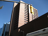
Stelco Tower
Stelco Tower is the second tallest building in Hamilton, Ontario, Canada. The 26-storey structure was completed in 1973. Originally known as Stelco Tower and now officially known as the 100 King Street West building, many Hamiltonians still refer to it as the Stelco Tower.The tower was built as...
and Bank of Montreal Pavilion in 1972. Then in 1977, the second phase of Jackson Square was completed with a six-storey office tower, but not the department store intended to be its major attraction. Also in 1977, The Art Gallery of Hamilton
Art Gallery of Hamilton
Art Gallery of Hamilton, is located in the heart of downtown Hamilton, Ontario on King Street West and is one of Canada’s oldest galleries with a collection of over 9,000 works of art.-History:...
opened beside the Board of Education building. In 1981, The Hamilton Convention Centre and the government office tower above it opened. The tower was named the Ellen Fairclough Building
Ellen Fairclough Building
Ellen Fairclough Building, 20-storey high rise office building built in 1981 is the 4th tallest building in Hamilton, Ontario, Canada. It's situated on the corner of King Street East and MacNab Street South....
one year later in 1982. In 1983, the Standard Life Centre opened at the west end of Jackson Square. In 1985, Sheraton Hamilton
Sheraton Hamilton
Sheraton Hamilton, built in 1985, is a 19-storey, , 299 room hotel in downtown Hamilton, Ontario, Canada. Situated on King Street West, East of Bay Street North, the hotel is part of the Lloyd D. Jackson Square Mall complex....
, connected to Jackson Square, opened, boosting downtown Hamilton's hotel space. In 1985, Copps Coliseum
Copps Coliseum
Copps Coliseum is a sports and entertainment arena, on the corner of Bay Street North and York Boulevard, in Hamilton, Ontario. Depending on event, the Copps Coliseum has a capacity of up to 19,000.It is named after the former Hamilton mayor, Victor K...
, sports and entertainment arena with a capacity of up to 19,000 (depending on event type and configuration) opens its doors for business (one block North of King Street at Bay Street
Bay Street (Hamilton)
Bay Street is a Lower City arterial road in Hamilton, Ontario, Canada. It starts at Inglewood Drive, just South of Aberdeen Avenue, as a collector road with only two lanes, then eventually becomes a six lane thoroughfare at its peak. Bay Street also passes through Downtown Hamilton, where many...
). It's named after the former Hamilton mayor, Victor K. Copps. In 1987, the first of two reflective glass buildings of the CIBC tower (Commerce Place I
Commerce Place I
Commerce Place I, the first tower built in 1987 and part of a twin tower complex. The complex is known as Commerce Place. The second tower; Commerce Place II was built in 1990. The 16-storey twin towers stand at 81.0 meters. This makes Commerce Place the 7th tallest building complex in Hamilton,...
) opened at King and James opposite Gore Park. The other (Commerce Place II
Commerce Place II
Commerce Place II is a building in Hamilton, Ontario, Canada, the second tower built in 1990 and part of a twin tower complex. The complex is known as Commerce Place. The first tower; Commerce Place I was built in 1987. The 16-storey twin towers stand at 81.0 meters. This makes Commerce Place the...
) opened in 1990.
Culture
Hamilton has hosted several cultural and craft fairs since the 1960s, notably Festival of FriendsFestival of Friends
The Festival of Friends is an annual three-day free summer music festival held on the second weekend of August at the Gage Park in Hamilton, Ontario. The 35th year saw it at Ancaster Fairgrounds. It is the largest annual event of its kind in Canada...
, which made it a major tourist destination. The Festival of Friends, founded in 1975, is the largest annual free music event in the country. Burton Cummings
Burton Cummings
Burton L. Cummings, OC, OM is a Canadian musician and songwriter.He was the lead singer and frequent keyboardist for the Canadian rock band The Guess Who...
, Lighthouse and Bruce Cockburn
Bruce Cockburn
Bruce Douglas Cockburn OC is a Canadian folk/rock guitarist and singer-songwriter. His most recent album was released in March 2011. He has written songs in styles ranging from folk to jazz-influenced rock to rock and roll.-Biography:...
have been among the main stage headliners at Gage Park on Gage Avenue
Gage Avenue (Hamilton, Ontario)
thumb|right|350px|Gage Park WaterfountainGage Avenue, is a Lower City arterial road in Hamilton, Ontario, Canada. It starts off at Lawrence Road at the base of the Niagara Escarpment at the south end of Gage Park...
. WestJet
WestJet
WestJet Airlines Ltd. is a Canadian low-cost carrier that provides scheduled and charter air service to 71 destinations in Canada, the United States, Mexico and the Caribbean. Founded in 1996, WestJet is currently the second largest Canadian air carrier, behind Air Canada, operating an average of...
is a major sponsor of the festival. Hamilton is also home to the Mustard Festivalhttp://www.hamiltoninternationalvillage.ca/index.asp because Hamilton is home to the largest miller of dry mustard in the world. It's held annually at Ferguson Station, Ferguson Avenue
Ferguson Avenue (Hamilton, Ontario)
Ferguson Avenue, is a Lower City collector road in Hamilton, Ontario, Canada. Is a two-way street throughout that starts off at the base of the Mountain on Foster Street. It's interrupted 3-blocks north at Corktown Park where Canadian Pacific Railway lines passes through it...
and King Street East at Hamilton's International Village and is another summertime food & beverage festival that features some of the top Blues and Jazz acts in the region.
In 2001, the Steven Seagal
Steven Seagal
Steven Frederic Seagal is an American action film star, producer, writer, martial artist, guitarist and reserve deputy sheriff. A 7th-dan black belt in Aikido, Seagal began his adult life as an Aikido instructor in Japan...
film Exit Wounds
Exit Wounds
Exit Wounds is a 2001 action film based on the book of the same name by John Westermann. The book takes place on Long Island, while the film is set in Detroit. The film was directed by Andrzej Bartkowiak, and stars Steven Seagal as an urban detective notorious for pushing the limits of the law in...
used the streets of Downtown Hamilton for a period of 6-weeks during a night shoot of the movie's climatic chase scene that features the Gore Park water fountain and the Hamilton GO Transit station, Original site of the Toronto, Hamilton and Buffalo Railway
Toronto, Hamilton and Buffalo Railway
The Toronto, Hamilton and Buffalo Railway was a railway based in Hamilton that ran in Southern Ontario from 1894 to 1987. It never reached the other two cities in its name, although it did have branch lines extending to Dunnville and Port Maitland.-History:...
(1892–1987).
Waterfront Shuttle
The Waterfront Shuttle is a free service offered by the Hamilton Street RailwayHamilton Street Railway
The Hamilton Street Railway Company is the Transit Division of the City of Hamilton, Public Works Department in Ontario, Canada. The name is a legacy of the days when the majority of public transit vehicles were streetcars; the present-day Hamilton Street Railway is in fact a bus operator...
. It has a seasonal schedule that runs weekends from May-to-October connecting Hamilton's downtown core to the waterfront and attractions that can be found there like HMCS Haida and the Parks Canada Discovery Centre. The route circles Hamilton's downtown core around York Boulevard
York Boulevard (Hamilton, Ontario)
York Boulevard is a Lower City arterial road in Hamilton, Ontario, Canada. Formerly known as Highway 2 and Highway 6,starts off in Burlington, Ontario at Plains Road West as a two-way arterial road that wraps around and over the Hamilton Harbour and enters the city of Hamilton in the West-end past...
(north), Bay Street South
Bay Street (Hamilton)
Bay Street is a Lower City arterial road in Hamilton, Ontario, Canada. It starts at Inglewood Drive, just South of Aberdeen Avenue, as a collector road with only two lanes, then eventually becomes a six lane thoroughfare at its peak. Bay Street also passes through Downtown Hamilton, where many...
(west), King Street West (south) and James Street North
James Street (Hamilton, Ontario)
James Street is a Lower City arterial road in Hamilton, Ontario, Canada. It starts off at the base of the Niagara Escarpment from James Mountain Road, a mountain-access road in the city, originally was a one-way street going south throughout but now has sections of it that are two-way...
(east). Then it travels north along James Street and the Art District until it reaches the waterfront at Guise Street past the Royal Hamilton Yacht Club
Royal Hamilton Yacht Club
The Royal Hamilton Yacht Club is located in Hamilton, Ontario, Canada, at the west end of Lake Ontario, and has been in existence since 1888. When the yacht club first opened, it was located at the foot of James Street North and then later moved to the foot of Bay Street...
, Hamilton Chamber of Commerce and the Harbour West Marina Complex. Then the route hangs a left on Discovery Drive, the site of the Parks Canada Discovery Centre. Also at this site is the Hamilton Harbour Queen (cruise boat), Hamiltonian (tour boat) and the Hamilton Waterfront Trolley.
Major intersections
Note: Listing of streets from West to East.- Longwood Road, South
 Chedoke Parkway, (Freeway passes underneath the King Street West bridge)
- Dundurn StreetDundurn Street (Hamilton, Ontario)Dundurn Street, is a Lower City arterial road in Hamilton, Ontario, Canada. It is a two-way street that starts off at Mountain Face Park, Niagara Escarpment in front of the Bruce Trail as a collector road, right behind Hillcrest Avenue and then turns into a four lane thoroughfare from Aberdeen...
, North, South - Locke Street, North, South
- Queen StreetQueen Street (Hamilton, Ontario)Queen Street, is a Lower City arterial road in Hamilton, Ontario, Canada. It starts off at Beckett Drive, a mountain-access road in the city and is a two-way street up to Herkimer Street and a one-way street the rest of the way north up to the Canadian National Railway Yard where the road turns...
, North, South - Hess StreetHess Street (Hamilton, Ontario)Hess Street, is a Lower City collector road in Hamilton, Ontario, Canada. It starts off at the base of the Niagara Escarpment right before Aberdeen Avenue, and is a one-way street going north past the Durand and Central neighbourhoods. Between Main and King Street West is where you will find Hess...
, North, South - Bay StreetBay Street (Hamilton)Bay Street is a Lower City arterial road in Hamilton, Ontario, Canada. It starts at Inglewood Drive, just South of Aberdeen Avenue, as a collector road with only two lanes, then eventually becomes a six lane thoroughfare at its peak. Bay Street also passes through Downtown Hamilton, where many...
, North, South - MacNab StreetMacNab Street (Hamilton, Ontario)MacNab Street, is a Lower City collector road in Hamilton, Ontario, Canada. It starts in the Durand neighbourhood on Markland Street, as a one-way street going north to Bold Street, where it becomes two-way for one block until Hurst Place where it's cut off by a wall for the Hunter Street railway...
, North, South - James StreetJames Street (Hamilton, Ontario)James Street is a Lower City arterial road in Hamilton, Ontario, Canada. It starts off at the base of the Niagara Escarpment from James Mountain Road, a mountain-access road in the city, originally was a one-way street going south throughout but now has sections of it that are two-way...
, North, South - Hughson StreetHughson Street (Hamilton, Ontario)Hughson Street is a Lower City collector road in Hamilton, Ontario, Canada. It starts at Charlton Avenue East at St. Joseph's hospital and runs north to Haymarket Street in the downtown where it's cut off by the Hamilton GO Transit station. Up to this point it is a two-way street...
, North, South - John StreetJohn Street (Hamilton, Ontario)John Street, is a Lower City arterial road in Hamilton, Ontario, Canada. Originally it was known as Mountain Road or Ancaster Road. It starts off at the base of Arkledun Avenue, a Mountain-access road in the city, just east of St.Joseph's Hospital where it's a one-way street going north and tunnels...
, North, South - Catharine StreetCatharine Street (Hamilton, Ontario)Catharine Street, is a Lower City collector road in Hamilton, Ontario, Canada. It starts off at Charlton Avenue East at Woolverton Park in the Corktown neighbourhood as a one-way street , tunnels underneath the Hunter Street Railway bridge and stretches up to Barton Street East where it then turns...
, North, South - Ferguson AvenueFerguson Avenue (Hamilton, Ontario)Ferguson Avenue, is a Lower City collector road in Hamilton, Ontario, Canada. Is a two-way street throughout that starts off at the base of the Mountain on Foster Street. It's interrupted 3-blocks north at Corktown Park where Canadian Pacific Railway lines passes through it...
, North, South - Wellington StreetWellington Street (Hamilton, Ontario)Wellington Street, is a Lower City arterial road in Hamilton, Ontario, Canada. It starts off at Charlton Avenue East as a two-way street for only one block where it's then blocked off by the Corktown Park and a couple of Canadian National Railway lines that cut through it...
, North, South - Victoria AvenueVictoria Avenue (Hamilton, Ontario)Victoria Avenue, is a Lower City arterial road in Hamilton, Ontario, Canada. It starts off as a ramp and part of a Mountain-access road, the Claremont Access, on Hunter Street East in the Stinson neighbourhood...
, North, South - Wentworth StreetWentworth Street (Hamilton, Ontario)Wentworth Street, is a Lower City arterial road in Hamilton, Ontario, Canada. It starts off at the base of the Niagara Escarpment on Charlton Avenue East just before the CP lines as a two-way street for 2-blocks up past Cumberland Avenue up to Rutherford Avenue where it then switches over to a...
, North, South - Sherman AvenueSherman Avenue (Hamilton, Ontario)Sherman Avenue, is a Lower City collector road in Hamilton, Ontario, Canada. It starts off at the base of the Niagara Escarpment just south of Cumberland Avenue and is a one-way street northbound that cuts through the city's North End industrial neighbourhood and ends at Ship Street, the site of...
, North, South - Gage AvenueGage Avenue (Hamilton, Ontario)thumb|right|350px|Gage Park WaterfountainGage Avenue, is a Lower City arterial road in Hamilton, Ontario, Canada. It starts off at Lawrence Road at the base of the Niagara Escarpment at the south end of Gage Park...
, North, South - Ottawa StreetOttawa Street (Hamilton, Ontario)Ottawa street, is a Lower City arterial road in Hamilton, Ontario, Canada. It starts off at Lawrence Road at the base of the Niagara Escarpment and is a two-way street throughout cutting through the Delta and Crown Point neighbourhoods and the City's North End industrial neighbourhood...
, South - Kenilworth AvenueKenilworth Avenue (Hamilton, Ontario)Kenilworth Avenue, is a Lower City arterial road in Hamilton, Ontario, Canada. It starts off at the Kenilworth Traffic Circle and Kenilworth Access, a mountain-access road at the base of the Niagara Escarpment and is a two-way street throughout stretching northward through the city's North End...
, South - Parkdale AvenueParkdale Avenue (Hamilton, Ontario)Parkdale Avenue, is a Lower City arterial road in Hamilton, Ontario, Canada. It starts off just South of Lawrence Road at Hixon Road and is a two-way street throughout, stretching northward through the city's North End industrial neighbourhood and ends just north of the Burlington Street East...
, South - Red Hill Valley ParkwayRed Hill Valley ParkwayThe Red Hill Valley Parkway , referred to as the Red Hill Creek Expressway during planning is a municipal expressway in the Canadian city of Hamilton, Ontario. The route connects the Lincoln M. Alexander Parkway, Hamilton's second municipal expressway, to the Queen Elizabeth Way near Hamilton...
(Freeway passes underneath the King Street East bridge) - Nash RoadNash Road (Hamilton, Ontario)Nash Road is a Lower City street in Hamilton, Ontario, Canada. It starts off at King Street East in front of the Father Sean O'Sullivan Memorial Park and is a two-way collector road throughout that extends north to the Nashdale neighbourhood past Bancroft Street where it then hangs a right and...
, South - Centennial ParkwayCentennial Parkway (Hamilton, Ontario)Centennial Parkway, is a Lower City arterial road in Hamilton, Ontario, Canada. It is best known as the western terminus of former King's Highway 20, now maintained by the City of Hamilton...
, South - Lake Avenue Drive
- Gray Road
- Green Road