
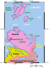
Killiniq Island
Encyclopedia
Killiniq Island is a small, remote island
in northeastern Canada
. Located at the extreme northern tip of Labrador
between Ungava Bay
and the Labrador Sea
, it is notable in that it contains the only land border between Nunavut
territory and the province of Newfoundland and Labrador
. Most other islands off the northern coast of Quebec and Labrador belong exclusively to Nunavut. Some cartographic sources do not correctly show the island's geopolitical boundaries.
The northernmost point of Newfoundland and Labrador is Cape Chidley
on the island. The largest identifiable land mass is the Torngat Mountains
, a part of the Arctic Cordillera
that proceed from the north to the south of the island.
A former community, meteorological station, coast guard
radio station, trading post
, missionary post, fishing station, and Royal Canadian Mounted Police
post existed through 1978 when it was evacuated by the government of the Northwest Territories
. The settlement, also called Killiniq
(alternate spelling: Killinek; also known as: Port Burwell; local variants: Killipaartalik or Kikkertaujak; previously: Bishop Jones' Village) was situated on what is now the Nunavut side of the island, part of the territory's Qikiqtaaluk Region. The locality was known by Europeans as early as 1569, marked on a Mercator
map. The island is now uninhabited. An automated remote radio transmitter for Iqaluit Coast Guard Radio remains in operation.
Island
An island or isle is any piece of sub-continental land that is surrounded by water. Very small islands such as emergent land features on atolls can be called islets, cays or keys. An island in a river or lake may be called an eyot , or holm...
in northeastern Canada
Canada
Canada is a North American country consisting of ten provinces and three territories. Located in the northern part of the continent, it extends from the Atlantic Ocean in the east to the Pacific Ocean in the west, and northward into the Arctic Ocean...
. Located at the extreme northern tip of Labrador
Labrador
Labrador is the distinct, northerly region of the Canadian province of Newfoundland and Labrador. It comprises the mainland portion of the province, separated from the island of Newfoundland by the Strait of Belle Isle...
between Ungava Bay
Ungava Bay
Ungava Bay is a large bay in northeastern Canada separating Nunavik from Baffin Island. The bay is shaped like a rounded square with a side length of about and has an area of approximately...
and the Labrador Sea
Labrador Sea
The Labrador Sea is an arm of the North Atlantic Ocean between the Labrador Peninsula and Greenland. The sea is flanked by continental shelves to the southwest, northwest, and northeast. It connects to the north with Baffin Bay through the Davis Strait...
, it is notable in that it contains the only land border between Nunavut
Nunavut
Nunavut is the largest and newest federal territory of Canada; it was separated officially from the Northwest Territories on April 1, 1999, via the Nunavut Act and the Nunavut Land Claims Agreement Act, though the actual boundaries had been established in 1993...
territory and the province of Newfoundland and Labrador
Newfoundland and Labrador
Newfoundland and Labrador is the easternmost province of Canada. Situated in the country's Atlantic region, it incorporates the island of Newfoundland and mainland Labrador with a combined area of . As of April 2011, the province's estimated population is 508,400...
. Most other islands off the northern coast of Quebec and Labrador belong exclusively to Nunavut. Some cartographic sources do not correctly show the island's geopolitical boundaries.
The northernmost point of Newfoundland and Labrador is Cape Chidley
Cape Chidley
Cape Chidley is a headland located on the eastern shore of Killiniq Island, Canada at the northeastern tip of the Labrador Peninsula.-Cape Chidley:...
on the island. The largest identifiable land mass is the Torngat Mountains
Torngat Mountains
The Torngat Mountains are a mountain range on the Labrador Peninsula at the northern tip of Newfoundland and Labrador and eastern Quebec. They are part of the Arctic Cordillera. This is the peninsula that separates Ungava Bay from the Atlantic Ocean....
, a part of the Arctic Cordillera
Arctic Cordillera
The Arctic Cordillera is a vast, deeply dissected chain of mountain ranges extending along the northeastern flank of the Canadian Arctic Archipelago from Ellesmere Island to the northeasternmost part of the Labrador Peninsula in northern Labrador and northern Quebec, Canada...
that proceed from the north to the south of the island.
A former community, meteorological station, coast guard
Canadian Coast Guard
The Canadian Coast Guard is the coast guard of Canada. It is a federal agency responsible for providing maritime search and rescue , aids to navigation, marine pollution response, marine radio, and icebreaking...
radio station, trading post
Trading post
A trading post was a place or establishment in historic Northern America where the trading of goods took place. The preferred travel route to a trading post or between trading posts, was known as a trade route....
, missionary post, fishing station, and Royal Canadian Mounted Police
Royal Canadian Mounted Police
The Royal Canadian Mounted Police , literally ‘Royal Gendarmerie of Canada’; colloquially known as The Mounties, and internally as ‘The Force’) is the national police force of Canada, and one of the most recognized of its kind in the world. It is unique in the world as a national, federal,...
post existed through 1978 when it was evacuated by the government of the Northwest Territories
Northwest Territories
The Northwest Territories is a federal territory of Canada.Located in northern Canada, the territory borders Canada's two other territories, Yukon to the west and Nunavut to the east, and three provinces: British Columbia to the southwest, and Alberta and Saskatchewan to the south...
. The settlement, also called Killiniq
Killiniq, Nunavut
Killiniq is a former Inuit settlement, weather station, trading post, missionary post, fishing station, and Royal Canadian Mounted Police post on Killiniq Island...
(alternate spelling: Killinek; also known as: Port Burwell; local variants: Killipaartalik or Kikkertaujak; previously: Bishop Jones' Village) was situated on what is now the Nunavut side of the island, part of the territory's Qikiqtaaluk Region. The locality was known by Europeans as early as 1569, marked on a Mercator
Gerardus Mercator
thumb|right|200px|Gerardus MercatorGerardus Mercator was a cartographer, born in Rupelmonde in the Hapsburg County of Flanders, part of the Holy Roman Empire. He is remembered for the Mercator projection world map, which is named after him...
map. The island is now uninhabited. An automated remote radio transmitter for Iqaluit Coast Guard Radio remains in operation.