
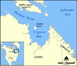
Ungava Bay
Encyclopedia
Ungava Bay is a large bay
in northeastern Canada
separating Nunavik
(far northern Quebec
) from Baffin Island
. The bay is shaped like a rounded square with a side length of about 180 km (111.8 mi) and has an area of approximately 33000 km² (12,741.4 sq mi). It is generally fairly shallow, though at its border with the Atlantic Ocean
depths of 300 m (984.3 ft) are reached.
, and others north of 60°N
are part of the territory of Nunavut
, whilst smaller islands south of 60°N belong to Quebec.
Although it is quite close to the open Atlantic (separated only by Hudson Strait
), Ungava Bay is generally considered part of the Arctic Ocean
because the land surrounding it has an exceedingly cold climate. Due to the influence of the Labrador Current
, summers are too cold for tree
growth and all the land surrounding the bay is treeless tundra
. Typically, temperatures in summer at Kuujjuaq about twenty kilometres up the Koksoak River
are about 7 °C (44.6 °F), whilst winter temperatures are about −20 C. Precipitation
averages around 400 – per year, most of it falling in the summer.
The southwestern corner of Ungava Bay, along with Bay of Fundy
, has either the highest or second-highest tidal ranges
in the world. Some sources estimate the spring tide range at the mouth of the Leaf River
as being as high as 17 m (55.8 ft). Attempts have been made to develop tidal power in the bay, but this is made difficult by the harsh climate and the fact that the bay is ice-free for only a small part of the year.
Bathymetric
studies suggest Ungava Bay may be the remnant of an impact crater
(age unknown) approximately 220 km in diameter.
villages, the largest of which is Kuujjuaq, Quebec
, at the mouth of the Koksoak River
. Iron ore has been mined in the past, but despite the high grade of the ores the impossibility of cheap transportation meant that mining was discontinued in 1980. Traditional Inuit hunting activities still dominate the region's life, along with expensive adventure tourism
.
Headlands and bays
Headlands and bays are two related features of the coastal environment.- Geology and geography :Headlands and bays are often found on the same coastline. A bay is surrounded by land on three sides, whereas a headland is surrounded by water on three sides. Headlands are characterized by high,...
in northeastern Canada
Canada
Canada is a North American country consisting of ten provinces and three territories. Located in the northern part of the continent, it extends from the Atlantic Ocean in the east to the Pacific Ocean in the west, and northward into the Arctic Ocean...
separating Nunavik
Nunavik
Nunavik comprises the northern third of the province of Quebec, Canada. Covering a land area of 443,684.71 km² north of the 55th parallel, it is the homeland of the Inuit of Quebec...
(far northern Quebec
Quebec
Quebec or is a province in east-central Canada. It is the only Canadian province with a predominantly French-speaking population and the only one whose sole official language is French at the provincial level....
) from Baffin Island
Baffin Island
Baffin Island in the Canadian territory of Nunavut is the largest island in the Canadian Arctic Archipelago, the largest island in Canada and the fifth largest island in the world. Its area is and its population is about 11,000...
. The bay is shaped like a rounded square with a side length of about 180 km (111.8 mi) and has an area of approximately 33000 km² (12,741.4 sq mi). It is generally fairly shallow, though at its border with the Atlantic Ocean
Atlantic Ocean
The Atlantic Ocean is the second-largest of the world's oceanic divisions. With a total area of about , it covers approximately 20% of the Earth's surface and about 26% of its water surface area...
depths of 300 m (984.3 ft) are reached.
Geography
There are a number of islands within Ungava Bay. The largest, Akpatok IslandAkpatok Island
Akpatok Island is one of the uninhabited Canadian Arctic islands in the Qikiqtaaluk Region of Nunavut, Canada. It is the largest island in Ungava Bay on the northern coast of Quebec...
, and others north of 60°N
60th parallel north
The 60th parallel north is a circle of latitude that is 60 degrees north of the Earth's equatorial plane. It crosses Europe, Asia, the Pacific Ocean, North America, and the Atlantic Ocean....
are part of the territory of Nunavut
Nunavut
Nunavut is the largest and newest federal territory of Canada; it was separated officially from the Northwest Territories on April 1, 1999, via the Nunavut Act and the Nunavut Land Claims Agreement Act, though the actual boundaries had been established in 1993...
, whilst smaller islands south of 60°N belong to Quebec.
Although it is quite close to the open Atlantic (separated only by Hudson Strait
Hudson Strait
Hudson Strait links the Atlantic Ocean to Hudson Bay in Canada. It lies between Baffin Island and the northern coast of Quebec, its eastern entrance marked by Cape Chidley and Resolution Island. It is long...
), Ungava Bay is generally considered part of the Arctic Ocean
Arctic Ocean
The Arctic Ocean, located in the Northern Hemisphere and mostly in the Arctic north polar region, is the smallest and shallowest of the world's five major oceanic divisions...
because the land surrounding it has an exceedingly cold climate. Due to the influence of the Labrador Current
Labrador Current
The Labrador Current is a cold current in the North Atlantic Ocean which flows from the Arctic Ocean south along the coast of Labrador and passes around Newfoundland, continuing south along the east coast of Nova Scotia...
, summers are too cold for tree
Tree
A tree is a perennial woody plant. It is most often defined as a woody plant that has many secondary branches supported clear of the ground on a single main stem or trunk with clear apical dominance. A minimum height specification at maturity is cited by some authors, varying from 3 m to...
growth and all the land surrounding the bay is treeless tundra
Tundra
In physical geography, tundra is a biome where the tree growth is hindered by low temperatures and short growing seasons. The term tundra comes through Russian тундра from the Kildin Sami word tūndâr "uplands," "treeless mountain tract." There are three types of tundra: Arctic tundra, alpine...
. Typically, temperatures in summer at Kuujjuaq about twenty kilometres up the Koksoak River
Koksoak River
The Koksoak River is a river in northern Quebec, Canada, the largest river in the Nunavik region. The Inuit village and region's administrative center Kuujjuaq lies on the shores of the Koksoak, about south from its mouth.The name Koksoak is believed to originate from Moravian missionaries who...
are about 7 °C (44.6 °F), whilst winter temperatures are about −20 C. Precipitation
Precipitation (meteorology)
In meteorology, precipitation In meteorology, precipitation In meteorology, precipitation (also known as one of the classes of hydrometeors, which are atmospheric water phenomena is any product of the condensation of atmospheric water vapor that falls under gravity. The main forms of precipitation...
averages around 400 – per year, most of it falling in the summer.
The southwestern corner of Ungava Bay, along with Bay of Fundy
Bay of Fundy
The Bay of Fundy is a bay on the Atlantic coast of North America, on the northeast end of the Gulf of Maine between the Canadian provinces of New Brunswick and Nova Scotia, with a small portion touching the U.S. state of Maine...
, has either the highest or second-highest tidal ranges
Tide
Tides are the rise and fall of sea levels caused by the combined effects of the gravitational forces exerted by the moon and the sun and the rotation of the Earth....
in the world. Some sources estimate the spring tide range at the mouth of the Leaf River
Leaf River (Quebec)
Leaf River is a river in northern Quebec, Canada, at the northern limit of the tree line. It flows from Lake Minto northeast through the Ungava Peninsula into Leaf Bay off Ungava Bay over a distance of...
as being as high as 17 m (55.8 ft). Attempts have been made to develop tidal power in the bay, but this is made difficult by the harsh climate and the fact that the bay is ice-free for only a small part of the year.
Bathymetric
Bathymetry
Bathymetry is the study of underwater depth of lake or ocean floors. In other words, bathymetry is the underwater equivalent to hypsometry. The name comes from Greek βαθύς , "deep", and μέτρον , "measure"...
studies suggest Ungava Bay may be the remnant of an impact crater
Impact crater
In the broadest sense, the term impact crater can be applied to any depression, natural or manmade, resulting from the high velocity impact of a projectile with a larger body...
(age unknown) approximately 220 km in diameter.
Human development
Ungava Bay is surrounded by numerous InuitInuit
The Inuit are a group of culturally similar indigenous peoples inhabiting the Arctic regions of Canada , Denmark , Russia and the United States . Inuit means “the people” in the Inuktitut language...
villages, the largest of which is Kuujjuaq, Quebec
Kuujjuaq, Quebec
Kuujjuaq is the largest Inuit village in Nunavik, Quebec, Canada with a population of 2,132 as of the 2006 census. This is up roughly 10% from 1,932 as of the 2001 Census. It is the administrative capital of Nunavik and lies on the western shore of the Koksoak River.Kuujjuaq previously was known...
, at the mouth of the Koksoak River
Koksoak River
The Koksoak River is a river in northern Quebec, Canada, the largest river in the Nunavik region. The Inuit village and region's administrative center Kuujjuaq lies on the shores of the Koksoak, about south from its mouth.The name Koksoak is believed to originate from Moravian missionaries who...
. Iron ore has been mined in the past, but despite the high grade of the ores the impossibility of cheap transportation meant that mining was discontinued in 1980. Traditional Inuit hunting activities still dominate the region's life, along with expensive adventure tourism
Tourism
Tourism is travel for recreational, leisure or business purposes. The World Tourism Organization defines tourists as people "traveling to and staying in places outside their usual environment for not more than one consecutive year for leisure, business and other purposes".Tourism has become a...
.
External links
- Northern Tidal Flows: Reliable New Power Source for Quebec?: Includes discussion of Ungava Bay as a feasible location for tidal power generation. (PESN; Aug. 14, 2006)
- Across Arctic Ungava (1949). A online documentary from the National Film Board of CanadaNational Film Board of CanadaThe National Film Board of Canada is Canada's twelve-time Academy Award-winning public film producer and distributor. An agency of the Government of Canada, the NFB produces and distributes documentary, animation, alternative drama and digital media productions...
.