

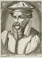
Gerardus Mercator
Encyclopedia
Rupelmonde
Rupelmonde is a town in the municipality of Kruibeke, in the Belgian province of East Flanders. It stands on the bank of the river Schelde opposite the confluence of the eponymous Rupel, and is famed for its sundials as well as having what is probably Belgium's only tidemill...
in the Hapsburg County of Flanders
County of Flanders
The County of Flanders was one of the territories constituting the Low Countries. The county existed from 862 to 1795. It was one of the original secular fiefs of France and for centuries was one of the most affluent regions in Europe....
, part of the Holy Roman Empire
Holy Roman Empire
The Holy Roman Empire was a realm that existed from 962 to 1806 in Central Europe.It was ruled by the Holy Roman Emperor. Its character changed during the Middle Ages and the Early Modern period, when the power of the emperor gradually weakened in favour of the princes...
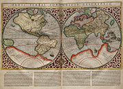
. He is remembered for the Mercator projection
Mercator projection
The Mercator projection is a cylindrical map projection presented by the Belgian geographer and cartographer Gerardus Mercator, in 1569. It became the standard map projection for nautical purposes because of its ability to represent lines of constant course, known as rhumb lines or loxodromes, as...
world map
World map
A world map is a map of the surface of the Earth, which may be made using any of a number of different map projections. A map projection is any method of representing the surface of a sphere or other three-dimensional body on a plane....
, which is named after him. This proved very useful to many later navigators who could (using his map) sail across the entire ocean on approximately straight paths (called rhumb lines
Rhumb line
In navigation, a rhumb line is a line crossing all meridians of longitude at the same angle, i.e. a path derived from a defined initial bearing...
). He died in Duisburg
Duisburg
- History :A legend recorded by Johannes Aventinus holds that Duisburg, was built by the eponymous Tuisto, mythical progenitor of Germans, ca. 2395 BC...
.
Life and works
Mercator was born Gerard de gemor or de Cremer in the Flemish town of RupelmondeRupelmonde
Rupelmonde is a town in the municipality of Kruibeke, in the Belgian province of East Flanders. It stands on the bank of the river Schelde opposite the confluence of the eponymous Rupel, and is famed for its sundials as well as having what is probably Belgium's only tidemill...
to parents from Gangelt
Gangelt
Gangelt is a municipality in the district Heinsberg, in North Rhine-Westphalia, Germany. It is situated on the border with the Netherlands, approx. 10 km east of Sittard and 10 km south-west of Heinsberg. Gangelt was the town in which Gerard Kremer, better known as Gerardus Mercator,...
in the Duchy of Jülich
Duchy of Jülich
The Duchy of Jülich comprised a state within the Holy Roman Empire from the 11th to the 18th centuries. The duchy lay left of the Rhine river between the Electorate of Cologne in the east and the Duchy of Limburg in the west. It had territories on both sides of the river Rur, around its capital...
, where he was raised. "Mercator" is the Latinized form of his name. It means "merchant". He was educated in 's-Hertogenbosch by the famous humanist Macropedius
Macropedius
Georgius Macropedius , also known as Joris van Lanckvelt, was a Dutch humanist, schoolmaster and 'the greatest Latin playwright of the 16th century'.-Biography:...
and at the University of Leuven
Old University of Leuven
The Old University of Leuven is the name historians give to the university, or studium generale, founded in Leuven, Brabant , in 1425, and closed in 1797, a week after the cession to the French Republic of the Austrian Netherlands and the principality of Liège by the Treaty of Campo Formio.When...
. Despite Mercator's fame as a cartographer, his main source of income came through his craftsmanship of mathematical instruments. In Leuven, he worked with Gemma Frisius
Gemma Frisius
Gemma Frisius , was a physician, mathematician, cartographer, philosopher, and instrument maker...
and Gaspar Myrica from 1535 to 1536 to construct a terrestrial globe
Globe
A globe is a three-dimensional scale model of Earth or other spheroid celestial body such as a planet, star, or moon...
, although the role of Mercator in the project was not primarily as a cartographer, but rather as a highly skilled engraver of brass plates. Mercator's own independent map-making began only when he produced a map of Palestine
Palestine
Palestine is a conventional name, among others, used to describe the geographic region between the Mediterranean Sea and the Jordan River, and various adjoining lands....
in 1537; this map was followed by another—a map of the world (1538) – and a map of Flanders (1540). During this period he learned Italic script
Italic script
Italic script, also known as chancery cursive, is a semi-cursive, slightly sloped style of handwriting and calligraphy that was developed during the Renaissance in Italy...
because it was the most suitable type of script for copper engraving of maps. He wrote the first instruction book of Italic script published in northern Europe
Europe
Europe is, by convention, one of the world's seven continents. Comprising the westernmost peninsula of Eurasia, Europe is generally 'divided' from Asia to its east by the watershed divides of the Ural and Caucasus Mountains, the Ural River, the Caspian and Black Seas, and the waterways connecting...
.
Heresy
Heresy is a controversial or novel change to a system of beliefs, especially a religion, that conflicts with established dogma. It is distinct from apostasy, which is the formal denunciation of one's religion, principles or cause, and blasphemy, which is irreverence toward religion...
in 1544 on the basis of his sympathy for Protestant beliefs and suspicions about his frequent travels. He was in prison for seven months before the charges were dropped—possibly because of intervention from the university authorities.
Duisburg
- History :A legend recorded by Johannes Aventinus holds that Duisburg, was built by the eponymous Tuisto, mythical progenitor of Germans, ca. 2395 BC...
, one of the major cities in the Duchy of Cleves
Duchy of Cleves
The Duchy of Cleves was a State of the Holy Roman Empire. It was situated in the northern Rhineland on both sides of the Lower Rhine, around its capital Cleves and the town of Wesel, bordering the lands of the Prince-Bishopric of Münster in the east and the Duchy of Brabant in the west...
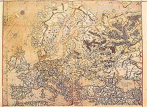
, and opened a cartographic workshop where he completed a six-panel map of Europe in 1554. He worked also as a surveyor for the city. His motives for moving to Duisburg are not clear. Mercator might have left the Netherlands for religious reasons or because he was informed about the plans to found a university. He taught mathematics
Mathematics
Mathematics is the study of quantity, space, structure, and change. Mathematicians seek out patterns and formulate new conjectures. Mathematicians resolve the truth or falsity of conjectures by mathematical proofs, which are arguments sufficient to convince other mathematicians of their validity...
at the academic college of Duisburg. After producing several maps, he was appointed Court Cosmographer to Wilhelm, Duke of Jülich-Cleves-Berg
Wilhelm, Duke of Jülich-Cleves-Berg
William of Jülich-Cleves-Berg was a Duke of Jülich-Cleves-Berg .William was born in and died in Düsseldorf. He was the only son of John III, Duke of Jülich-Cleves-Berg, and Maria, Duchess of Jülich-Berg. William took over rule of his father's estates upon his death in 1539...
in 1564. He constructed a new chart
Nautical chart
A nautical chart is a graphic representation of a maritime area and adjacent coastal regions. Depending on the scale of the chart, it may show depths of water and heights of land , natural features of the seabed, details of the coastline, navigational hazards, locations of natural and man-made aids...
and first used it in 1569. It had parallel lines of longitude to aid navigation by sea, and compass courses could be marked as straight lines.
Mercator took the word atlas to describe a collection of maps, and encouraged Abraham Ortelius
Abraham Ortelius
thumb|250px|Abraham Ortelius by [[Peter Paul Rubens]]Abraham Ortelius thumb|250px|Abraham Ortelius by [[Peter Paul Rubens]]Abraham Ortelius (Abraham Ortels) thumb|250px|Abraham Ortelius by [[Peter Paul Rubens]]Abraham Ortelius (Abraham Ortels) (April 14, 1527 – June 28,exile in England to take...
to compile the first modern world atlas – Theatrum Orbis Terrarum
Theatrum Orbis Terrarum
Theatrum Orbis Terrarum is considered to be the first true modern atlas. Written by Abraham Ortelius and originally printed on May 20, 1570, in Antwerp, it consisted of a collection of uniform map sheets and sustaining text bound to form a book for which copper printing plates were specifically...
– in 1570. He produced his own atlas in a number of parts, the first of which was published in 1578 and consisted of corrected versions of the maps of Ptolemy
Ptolemy
Claudius Ptolemy , was a Roman citizen of Egypt who wrote in Greek. He was a mathematician, astronomer, geographer, astrologer, and poet of a single epigram in the Greek Anthology. He lived in Egypt under Roman rule, and is believed to have been born in the town of Ptolemais Hermiou in the...
(though introducing a number of new errors). Maps of France
France
The French Republic , The French Republic , The French Republic , (commonly known as France , is a unitary semi-presidential republic in Western Europe with several overseas territories and islands located on other continents and in the Indian, Pacific, and Atlantic oceans. Metropolitan France...
, Germany
Germany
Germany , officially the Federal Republic of Germany , is a federal parliamentary republic in Europe. The country consists of 16 states while the capital and largest city is Berlin. Germany covers an area of 357,021 km2 and has a largely temperate seasonal climate...
and the Netherlands
Netherlands
The Netherlands is a constituent country of the Kingdom of the Netherlands, located mainly in North-West Europe and with several islands in the Caribbean. Mainland Netherlands borders the North Sea to the north and west, Belgium to the south, and Germany to the east, and shares maritime borders...
were added in 1585 and of the Balkans and Greece
Greece
Greece , officially the Hellenic Republic , and historically Hellas or the Republic of Greece in English, is a country in southeastern Europe....
in 1588; further maps were published by Mercator's son Rumold Mercator
Rumold Mercator
Rumold Mercator was a cartographer and the son of cartographer Gerardus Mercator.He completed some at the time unfinished projects left after his father's death and added new materials of his own researches....
in 1595 after the death of his father.
Mercator devised a technique to produce globe
Globe
A globe is a three-dimensional scale model of Earth or other spheroid celestial body such as a planet, star, or moon...
s — celestial as well as terrestrial — by techniques of relative mass production. Globes at the time were laboriously produced by engraving upon a sphere of wood or gilded brass. Mercator moulded globes of papier-mâché
Papier-mâché
Papier-mâché , alternatively, paper-mache, is a composite material consisting of paper pieces or pulp, sometimes reinforced with textiles, bound with an adhesive, such as glue, starch, or wallpaper paste....
on a wooden mould, then cut them along the equator; once reassembled, the globes were coated with gesso
Gesso
Gesso is a white paint mixture consisting of a binder mixed with chalk, gypsum, pigment, or any combination of these...
, a white mixture of thin plaster and sizing. Mercator engraved and printed sets of world maps on twelve tapering gores
Gore (segment)
A gore is a segment of a three-dimensional shape fabricated from a two-dimensional material. The term was originally used to describe triangular shapes, but is now extended to any shape that can be used to create the third dimension.-Examples:...
, with curved edges that narrowed towards the poles. These twelve gores were cut out and applied to the globe. Circular engraved caps covered the ends at the poles. After the globes were hand-tinted with watercolors, they were set in wooden stands with calibrated brass horizon rings. Twenty-two such pairs of Mercator globes have survived.
Following his move to Duisburg, Mercator never left the city and died there, a respected and wealthy citizen. He is buried in the city's main church of Saint Salvatorus. Exhibits of his works can be seen in the Mercator treasury located in the city.
More exhibits about Mercator's life and work are featured at the Mercator Museum in Sint-Niklaas
Sint-Niklaas
Sint-Niklaas is a Belgian city and municipality located in the Flemish province of East Flanders. The municipality comprises the city of Sint-Niklaas proper and the towns of Belsele, Nieuwkerken-Waas, and Sinaai....
, Belgium
Belgium
Belgium , officially the Kingdom of Belgium, is a federal state in Western Europe. It is a founding member of the European Union and hosts the EU's headquarters, and those of several other major international organisations such as NATO.Belgium is also a member of, or affiliated to, many...
.
Further reading
- Nicholas Crane: Mercator: the man who mapped the planet, London: Phoenix, 2003, ISBN 075381692X