
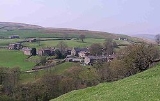
Keld, North Yorkshire
Encyclopedia
Keld is a hamlet
in the English
county of North Yorkshire
. It is situated on Swaledale, in the Yorkshire Dales
. The name derives from the Viking word Kelda meaning a spring, and the village was once called Appletre Kelde - the spring near the apple trees.
Keld is the crossing point of the Coast to Coast Walk
and the Pennine Way
long distance footpaths at the head of Swaledale
. At the height of the lead-mining boom in Swaledale in the late 19th century, the village had a population of around 6,000. During this period, a series of remarkable buildings - now Grade II listed - were erected: these include the Congregational and Methodist chapels, the school and the Literary Institute.
Unfortunately Keld does not contain a shop. There was a Youth Hostel but this closed in October 2006; the building has since reopened as Keld Lodge, a hotel with bar and restaurant. There is a series of four waterfalls close to Keld at a limestone
gorge on the River Swale
. These are Kisdon Force
, East Gill Force
, Catrake Force
and Wain Wath Force
.
, a local charity linked to the faith sector, is restoring a series of listed buildings in the village centre and returning them to community use. The first phase involved restoration of the Manse, the Minister's house attached to the United Reformed Church
, which was completed in 2009 and is now in use as a holiday cottage, proceeds from which support the Centre's work.
In 2010, the Centre created the Keld Well-being Garden in the chapel churchyard. It provides a quiet spot for visitors to contemplate their well-being in the beautiful natural environment of Upper Swaledale.
The Centre's latest project is the Keld Countryside and Heritage Centre. Opened on 14 May 2011, the centre provides interpretation of the countryside, built and social history of Keld, and a small display of artefacts relevant to Upper Swaledale prepared by the Swaledale Museum
in Reeth
. It is open throughout the year.
Further projects involve restoring the former school, Literary Institute and, potentially, Methodist Chapel.
, who visited the Dale occasionally to shoot the red deer
. Survey work by the Yorkshire Dales National Park Authority has shown that the building has changed many times over the years. At one time it even had a heather or "ling"
thatched roof.
oct2003.jpg) The current ruin is of a farmhouse dating from the mid 18th century. It was an impressive two-storey building with a slate
The current ruin is of a farmhouse dating from the mid 18th century. It was an impressive two-storey building with a slate
roof and matching "shippons" or cow sheds at each end for animals. The building may also have been used as mine offices, as intensive lead mining was carried out in the area, and there were violent disputes over mine boundaries in the 18th century.
In the 1930s Ella Pontefract and Marie Hartley wrote of a wild 4-year-old child living here by the name of Alice.
The current building was abandoned in the 1950s because of subsidence
. Crackpot Hall has been saved from further decay by Gunnerside Estate with the aid of grants from the Millennium Commission
and European Union
through the Yorkshire Dales Millennium Trust.
The name Crackpot is said to be Viking
for "a deep hole or chasm that is a haunt of crows".
Hamlet (place)
A hamlet is usually a rural settlement which is too small to be considered a village, though sometimes the word is used for a different sort of community. Historically, when a hamlet became large enough to justify building a church, it was then classified as a village...
in the English
England
England is a country that is part of the United Kingdom. It shares land borders with Scotland to the north and Wales to the west; the Irish Sea is to the north west, the Celtic Sea to the south west, with the North Sea to the east and the English Channel to the south separating it from continental...
county of North Yorkshire
North Yorkshire
North Yorkshire is a non-metropolitan or shire county located in the Yorkshire and the Humber region of England, and a ceremonial county primarily in that region but partly in North East England. Created in 1974 by the Local Government Act 1972 it covers an area of , making it the largest...
. It is situated on Swaledale, in the Yorkshire Dales
Yorkshire Dales
The Yorkshire Dales is the name given to an upland area in Northern England.The area lies within the historic county boundaries of Yorkshire, though it spans the ceremonial counties of North Yorkshire, West Yorkshire and Cumbria...
. The name derives from the Viking word Kelda meaning a spring, and the village was once called Appletre Kelde - the spring near the apple trees.
Keld is the crossing point of the Coast to Coast Walk
Coast to Coast Walk
The Coast to Coast Walk is a 192-mile unofficial and mostly unsignposted long distance footpath in Northern England...
and the Pennine Way
Pennine Way
The Pennine Way is a National Trail in England. The trail runs from Edale, in the northern Derbyshire Peak District, north through the Yorkshire Dales and the Northumberland National Park and ends at Kirk Yetholm, just inside the Scottish border. The path runs along the Pennine hills, sometimes...
long distance footpaths at the head of Swaledale
Swaledale
Swaledale is one of the northernmost dales in the Yorkshire Dales National Park in northern England. It is the dale of the River Swale on the east side of the Pennines in North Yorkshire.-Geographical overview:...
. At the height of the lead-mining boom in Swaledale in the late 19th century, the village had a population of around 6,000. During this period, a series of remarkable buildings - now Grade II listed - were erected: these include the Congregational and Methodist chapels, the school and the Literary Institute.
Unfortunately Keld does not contain a shop. There was a Youth Hostel but this closed in October 2006; the building has since reopened as Keld Lodge, a hotel with bar and restaurant. There is a series of four waterfalls close to Keld at a limestone
Limestone
Limestone is a sedimentary rock composed largely of the minerals calcite and aragonite, which are different crystal forms of calcium carbonate . Many limestones are composed from skeletal fragments of marine organisms such as coral or foraminifera....
gorge on the River Swale
River Swale
The River Swale is a river in Yorkshire, England and a major tributary of the River Ure, which itself becomes the River Ouse, emptying into the North Sea via the Humber Estuary....
. These are Kisdon Force
Kisdon Force
Kisdon Force is a series of waterfalls on the River Swale in Swaledale, England. The falls are situated at grid reference within the Yorkshire Dales National Park in the county of North Yorkshire, 500 metres downstream from the small hamlet of Keld....
, East Gill Force
East Gill Force
East Gill Force is a waterfalls in Swaledale, 300 metres to the east of the hamlet of Keld, in the Yorkshire Dales National Park, North Yorkshire, England. The falls are located on East Gill at grid reference , just before its confluence with the River Swale at the point where the Pennine Way and...
, Catrake Force
Catrake Force
Catrake Force is a waterfall on the river Swale in North Yorkshire, England. It is not visible from the road but only a short walk to reach it. It comprises a series of 4 steps each its own small waterfall and each with a very different character with the largest single drop being about .It lies on...
and Wain Wath Force
Wain Wath Force
Wain Wath Force is a waterfall situated on the River Swale in the Yorkshire Dales National Park, North Yorkshire, England. The falls are located at grid reference , one kilometre upstream from the hamlet of Keld which has three other waterfalls in its vicinity, namely Kisdon Force, East Gill Force...
.
Keld Resource Centre
The Keld Resource CentreKeld Resource Centre
The Keld Resource Centre is a charity based in the small village of Keld in Upper Swaledale, North Yorkshire. It is restoring a series of remarkable listed buildings in the village, and returning them to a range of community uses.Completed projects:...
, a local charity linked to the faith sector, is restoring a series of listed buildings in the village centre and returning them to community use. The first phase involved restoration of the Manse, the Minister's house attached to the United Reformed Church
United Reformed Church
The United Reformed Church is a Christian church in the United Kingdom. It has approximately 68,000 members in 1,500 congregations with some 700 ministers.-Origins and history:...
, which was completed in 2009 and is now in use as a holiday cottage, proceeds from which support the Centre's work.
In 2010, the Centre created the Keld Well-being Garden in the chapel churchyard. It provides a quiet spot for visitors to contemplate their well-being in the beautiful natural environment of Upper Swaledale.
The Centre's latest project is the Keld Countryside and Heritage Centre. Opened on 14 May 2011, the centre provides interpretation of the countryside, built and social history of Keld, and a small display of artefacts relevant to Upper Swaledale prepared by the Swaledale Museum
Swaledale Museum
Swaledale Museum is a local museum in the village of Reeth, near Richmond in North Yorkshire, England. It covers rural history including life and work in the local area of Swaledale and Arkengarthdale within the Yorkshire Dales national park.- History :...
in Reeth
Reeth
Reeth is a village in the Yorkshire Dales within the Richmondshire district of North Yorkshire, England and principal settlement of Swaledale. It is situated at the meeting point of the two most northerly of the Yorkshire Dales: Swaledale and Arkengarthdale....
. It is open throughout the year.
Further projects involve restoring the former school, Literary Institute and, potentially, Methodist Chapel.
Crackpot Hall
The ruins of Crackpot Hall lie about a mile east of Keld on the northern slope of the dale at . There may have been a building on this site since the 16th century when a hunting lodge was maintained for Thomas, the first Baron WhartonThomas Wharton, 1st Baron Wharton
Thomas Wharton, 1st Baron Wharton was an English nobleman and a follower of King Henry VIII of England. He is best known for his victory at Solway Moss on 24 November 1542 for which he was given a barony.-Early life:...
, who visited the Dale occasionally to shoot the red deer
Red Deer
The red deer is one of the largest deer species. Depending on taxonomy, the red deer inhabits most of Europe, the Caucasus Mountains region, Asia Minor, parts of western Asia, and central Asia. It also inhabits the Atlas Mountains region between Morocco and Tunisia in northwestern Africa, being...
. Survey work by the Yorkshire Dales National Park Authority has shown that the building has changed many times over the years. At one time it even had a heather or "ling"
Calluna
Calluna vulgaris is the sole species in the genus Calluna in the family Ericaceae. It is a low-growing perennial shrub growing to tall, or rarely to and taller, and is found widely in Europe and Asia Minor on acidic soils in open sunny situations and in moderate shade...
thatched roof.
Slate
Slate is a fine-grained, foliated, homogeneous metamorphic rock derived from an original shale-type sedimentary rock composed of clay or volcanic ash through low-grade regional metamorphism. The result is a foliated rock in which the foliation may not correspond to the original sedimentary layering...
roof and matching "shippons" or cow sheds at each end for animals. The building may also have been used as mine offices, as intensive lead mining was carried out in the area, and there were violent disputes over mine boundaries in the 18th century.
In the 1930s Ella Pontefract and Marie Hartley wrote of a wild 4-year-old child living here by the name of Alice.
The current building was abandoned in the 1950s because of subsidence
Subsidence
Subsidence is the motion of a surface as it shifts downward relative to a datum such as sea-level. The opposite of subsidence is uplift, which results in an increase in elevation...
. Crackpot Hall has been saved from further decay by Gunnerside Estate with the aid of grants from the Millennium Commission
Millennium Commission
The Millennium Commission in the United Kingdom was set up to aid communities at the end of the 2nd millennium and the start of the 3rd millennium. It used funding raised through the UK National Lottery....
and European Union
European Union
The European Union is an economic and political union of 27 independent member states which are located primarily in Europe. The EU traces its origins from the European Coal and Steel Community and the European Economic Community , formed by six countries in 1958...
through the Yorkshire Dales Millennium Trust.
The name Crackpot is said to be Viking
Viking
The term Viking is customarily used to refer to the Norse explorers, warriors, merchants, and pirates who raided, traded, explored and settled in wide areas of Europe, Asia and the North Atlantic islands from the late 8th to the mid-11th century.These Norsemen used their famed longships to...
for "a deep hole or chasm that is a haunt of crows".