
Coast to Coast Walk
Encyclopedia
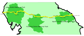
The Coast to Coast Walk is a 192-mile (according to a recent re-measuring the real distance is almost 220 miles, although it is difficult to find the source of this alleged re-measuring) unofficial and mostly unsignposted long distance footpath
in Northern England
. Devised by Alfred Wainwright
, it passes through three contrasting national parks
: the Lake District
National Park, the Yorkshire Dales
National Park, and the North York Moors
National Park.
Wainwright
recommends that walkers dip their booted feet in the Irish Sea
at St Bees
and, at the end of the walk, dip their naked feet in the North Sea
at Robin Hood's Bay
.
In 1991, the route was run in 39 hours 36 minutes and 52 seconds by Mike Hartley, setting a new record, beating the previous record set in 1985 by Mike Cudahy who completed it in 46 hours 49 minutes.
in his 1973 book "A Coast to Coast Walk". Due to legal restrictions with certain stretches of the path, increased traffic on some of the road sections, and erosion, the exact original route followed by Wainwright is not recommended. Wainwright's book has been revised a number of times in recent years (most recently in 2003) to provide a route which avoids trespass.
Wainwright's book describes the route in 12 stages, each of which ends at a settlement with at least some overnight accommodation. If one stage is walked per day, with one or two rest days, the route makes a two-week holiday, and web logs of coast-to-coasters seem to indicate that this is the most common way of walking the route. However, Wainwright explicitly states that he did not intend people to necessarily stick to these daily stages (or even to his route): splitting two or three stages and increasing the number of rest days reduces day-lengths to 10 or 12 miles) and makes the walk a much easier three-week trip with time to "stand and stare" (an activity much approved of by Wainwright).
Although unofficial, the Coast to Coast Walk uses public rights of way (public footpaths, tracks, and minor roads) and is one of the most popular of all the Long-distance footpaths in the UK. In 2004 the walk was named as the second best walk in the world according to a survey of experts. Harveys publish two dedicated strip maps at 1:40,000 scale.
 This is given here from west to east - the more popular direction, given in the original and most of the current guides, and the direction which keeps the prevailing wind and rain at one's back, and the evening sun out of one's eyes.
The route begins in West Cumbria, on the shores of the Irish Sea. People choose to begin at St Bees
, Whitehaven
or Workington
. The route then crosses the coastal plain, the Lake District
, the Pennines
and the North York Moors, and ends on the North Sea coast at Robin Hood's Bay
in Yorkshire
. Some walkers however, start from the east coast, preferring to have the Lake District as the climax of their walk.
Long-distance trail
Long-distance trails are the longer recreational trails mainly through rural areas, used for non-motorised recreational travelling ....
in Northern England
England
England is a country that is part of the United Kingdom. It shares land borders with Scotland to the north and Wales to the west; the Irish Sea is to the north west, the Celtic Sea to the south west, with the North Sea to the east and the English Channel to the south separating it from continental...
. Devised by Alfred Wainwright
Alfred Wainwright
Alfred Wainwright MBE was a British fellwalker, guidebook author and illustrator. His seven-volume Pictorial Guide to the Lakeland Fells, published between 1955 and 1966 and consisting entirely of reproductions of his manuscript, has become the standard reference work to 214 of the fells of the...
, it passes through three contrasting national parks
National park
A national park is a reserve of natural, semi-natural, or developed land that a sovereign state declares or owns. Although individual nations designate their own national parks differently A national park is a reserve of natural, semi-natural, or developed land that a sovereign state declares or...
: the Lake District
Lake District
The Lake District, also commonly known as The Lakes or Lakeland, is a mountainous region in North West England. A popular holiday destination, it is famous not only for its lakes and its mountains but also for its associations with the early 19th century poetry and writings of William Wordsworth...
National Park, the Yorkshire Dales
Yorkshire Dales
The Yorkshire Dales is the name given to an upland area in Northern England.The area lies within the historic county boundaries of Yorkshire, though it spans the ceremonial counties of North Yorkshire, West Yorkshire and Cumbria...
National Park, and the North York Moors
North York Moors
The North York Moors is a national park in North Yorkshire, England. The moors are one of the largest expanses of heather moorland in the United Kingdom. It covers an area of , and it has a population of about 25,000...
National Park.
Wainwright
Alfred Wainwright
Alfred Wainwright MBE was a British fellwalker, guidebook author and illustrator. His seven-volume Pictorial Guide to the Lakeland Fells, published between 1955 and 1966 and consisting entirely of reproductions of his manuscript, has become the standard reference work to 214 of the fells of the...
recommends that walkers dip their booted feet in the Irish Sea
Irish Sea
The Irish Sea separates the islands of Ireland and Great Britain. It is connected to the Celtic Sea in the south by St George's Channel, and to the Atlantic Ocean in the north by the North Channel. Anglesey is the largest island within the Irish Sea, followed by the Isle of Man...
at St Bees
St Bees
St Bees is a village and civil parish in the Copeland district of Cumbria, in the North of England, about five miles west southwest of Whitehaven. The parish had a population of 1,717 according to the 2001 census. Within the parish is St...
and, at the end of the walk, dip their naked feet in the North Sea
North Sea
In the southwest, beyond the Straits of Dover, the North Sea becomes the English Channel connecting to the Atlantic Ocean. In the east, it connects to the Baltic Sea via the Skagerrak and Kattegat, narrow straits that separate Denmark from Norway and Sweden respectively...
at Robin Hood's Bay
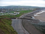
Robin Hood's Bay
Robin Hood’s Bay is a small fishing village and a bay located five miles south of Whitby and 15 miles north of Scarborough on the coast of North Yorkshire, England. Bay Town, its local name, is in the ancient chapelry of Fylingdales in the wapentake of Whitby Strand.-Toponymy:The origin of the name...
.
In 1991, the route was run in 39 hours 36 minutes and 52 seconds by Mike Hartley, setting a new record, beating the previous record set in 1985 by Mike Cudahy who completed it in 46 hours 49 minutes.
History and status
The Coast to Coast was described by A. WainwrightAlfred Wainwright
Alfred Wainwright MBE was a British fellwalker, guidebook author and illustrator. His seven-volume Pictorial Guide to the Lakeland Fells, published between 1955 and 1966 and consisting entirely of reproductions of his manuscript, has become the standard reference work to 214 of the fells of the...
in his 1973 book "A Coast to Coast Walk". Due to legal restrictions with certain stretches of the path, increased traffic on some of the road sections, and erosion, the exact original route followed by Wainwright is not recommended. Wainwright's book has been revised a number of times in recent years (most recently in 2003) to provide a route which avoids trespass.
Wainwright's book describes the route in 12 stages, each of which ends at a settlement with at least some overnight accommodation. If one stage is walked per day, with one or two rest days, the route makes a two-week holiday, and web logs of coast-to-coasters seem to indicate that this is the most common way of walking the route. However, Wainwright explicitly states that he did not intend people to necessarily stick to these daily stages (or even to his route): splitting two or three stages and increasing the number of rest days reduces day-lengths to 10 or 12 miles) and makes the walk a much easier three-week trip with time to "stand and stare" (an activity much approved of by Wainwright).
Although unofficial, the Coast to Coast Walk uses public rights of way (public footpaths, tracks, and minor roads) and is one of the most popular of all the Long-distance footpaths in the UK. In 2004 the walk was named as the second best walk in the world according to a survey of experts. Harveys publish two dedicated strip maps at 1:40,000 scale.
Route
The route begins in West Cumbria, on the shores of the Irish Sea. People choose to begin at St Bees
St Bees
St Bees is a village and civil parish in the Copeland district of Cumbria, in the North of England, about five miles west southwest of Whitehaven. The parish had a population of 1,717 according to the 2001 census. Within the parish is St...
, Whitehaven
Whitehaven
Whitehaven is a small town and port on the coast of Cumbria, England, which lies equidistant between the county's two largest settlements, Carlisle and Barrow-in-Furness, and is served by the Cumbrian Coast Line and the A595 road...
or Workington
Workington
Workington is a town, civil parish and port on the west coast of Cumbria, England, at the mouth of the River Derwent. Lying within the Borough of Allerdale, Workington is southwest of Carlisle, west of Cockermouth, and southwest of Maryport...
. The route then crosses the coastal plain, the Lake District
Lake District
The Lake District, also commonly known as The Lakes or Lakeland, is a mountainous region in North West England. A popular holiday destination, it is famous not only for its lakes and its mountains but also for its associations with the early 19th century poetry and writings of William Wordsworth...
, the Pennines
Pennines
The Pennines are a low-rising mountain range, separating the North West of England from Yorkshire and the North East.Often described as the "backbone of England", they form a more-or-less continuous range stretching from the Peak District in Derbyshire, around the northern and eastern edges of...
and the North York Moors, and ends on the North Sea coast at Robin Hood's Bay
Robin Hood's Bay
Robin Hood’s Bay is a small fishing village and a bay located five miles south of Whitby and 15 miles north of Scarborough on the coast of North Yorkshire, England. Bay Town, its local name, is in the ancient chapelry of Fylingdales in the wapentake of Whitby Strand.-Toponymy:The origin of the name...
in Yorkshire
Yorkshire
Yorkshire is a historic county of northern England and the largest in the United Kingdom. Because of its great size in comparison to other English counties, functions have been increasingly undertaken over time by its subdivisions, which have also been subject to periodic reform...
. Some walkers however, start from the east coast, preferring to have the Lake District as the climax of their walk.
Lake District
- From the small seaside town of St Bees, where there is a "C to C" monument by the lifeboat station, the route follows the cliffs of St Bees Head north for a few miles before turning inland to pass through the villages of Sandwith, Moor Row and Cleator in the West Cumberland Plain. It then climbs its first hill (DentDent (fell)Dent is a small fell on the fringe of the English Lake District near the towns of Cleator Moor and Egremont. Sometimes known as Long Barrow, it is traditionally the first fell encountered by hikers following Wainwright's Coast to Coast Walk...
), and follows its first valley (Nannycatch) before reaching Ennerdale BridgeEnnerdale BridgeEnnerdale Bridge is a settlement in the county of Cumbria, England.Ennerdale Bridge lies at the confluence of Croasdale Beck and the River Ehen and is on the border of the Lake District National Park that uses both watercourses as its boundary. The nearest town is Cleator Moor to its west...
. - The path goes up the valley of EnnerdaleRiver EhenThe River Ehen is a river in Cumbria, England. It is a designated Special Area of Conservation.The river's source is at the west end of Ennerdale Water: it runs west through Ennerdale Bridge where it is joined by Croasdale Beck...
along the edge of Ennerdale Water and past the Black Sail Hut youth hostel. It climbs alongside Loft Beck to the fellFell“Fell” is a word used to refer to mountains, or certain types of mountainous landscape, in Scandinavia, the Isle of Man, and parts of northern England.- Etymology :...
s north of Great GableGreat GableGreat Gable is a mountain lying at the very heart of the English Lake District, appearing as a pyramid from Wasdale , but as a dome from most other directions. It is one of the most popular of the Lakeland fells, and there are many different routes to the summit...
, passes the disused slate workings and mountain tramway of Honister, and descends to Rosthwaite in BorrowdaleBorrowdaleBorrowdale is a valley and civil parish in the English Lake District in the Borough of Allerdale in Cumbria, England.Borrowdale lies within the historic county boundaries of Cumberland, and is sometimes referred to as Cumberland Borrowdale in order to distinguish it from another Borrowdale in the...
. - To leave Borrowdale, the route passes Stonethwaite and follows the stream up to Greenup Edge, before travelling along the Helm CragHelm CragHelm Crag is a fell in the English Lake District situated in the Central Fells to the north of Grasmere. Despite its low height it sits prominently at the end of a ridge, easily seen from the village...
ridge and down to GrasmereGrasmereGrasmere is a village, and popular tourist destination, in the centre of the English Lake District. It takes its name from the adjacent lake, and is associated with the Lake Poets...
village. - From Grasmere the route ascends to the pass of Grisedale Hause from where Wainwright offers a choice of three routes: via either of the mountains of HelvellynHelvellynHelvellyn is a mountain in the English Lake District, the apex of the Eastern Fells. At above sea level, it is the third highest peak in both the Lake District and England...
or St Sunday CragSt Sunday CragSt Sunday Crag is a fell in the English Lake District, part of the Fairfield group in the Eastern Fells. It is a prominent feature in the Patterdale skyline, with a distinctive rounded shape...
, or an easier descent along Patterdale valley, the three options reuniting at PatterdalePatterdalePatterdale is a small village and civil parish in the eastern part of the English Lake District in the Eden District of Cumbria, and the long valley in which they are found, also called the Ullswater Valley....
village. - From Patterdale, a stiff climb leads to Angle Tarn and Kidsty PikeKidsty PikeKidsty Pike is a fell in the English Lake District, standing to the west of Haweswater Reservoir. It is a subsidiary top of Rampsgill Head, but has long achieved the status of a separate fell, thanks to its classic peaked profile...
— at 2,560 feet (780 metres) the highest point on the walk. There is then a steep drop to HaweswaterHaweswater ReservoirHaweswater is a reservoir in the English Lake District, built in the valley of Mardale in the county of Cumbria. The controversial construction of the Haweswater dam started in 1929, after Parliament passed an Act giving the Manchester Corporation permission to build the reservoir to supply water...
from where the route follows the north shore of the lake before leaving the Lake District and visiting Shap AbbeyShap AbbeyShap Abbey was a monastic religious house of the Premonstratensian order on the western bank of the River Lowther in the civil parish of Shap Rural, around from the village of Shap, in the Eden District of Cumbria, England...
and the village of ShapShapShap is a linear village and civil parish located amongst fells and isolated dales in Eden district, Cumbria, England. The village lies along the A6 road and the West Coast Main Line, and is near to the M6 motorway...
itself.
Westmorland and Yorkshire Dales
- From Shap the route crosses the limestone pavementLimestone pavementA limestone pavement is a natural karst landform consisting of a flat, incised surface of exposed limestone that resembles an artificial pavement. The term is mainly used in the UK where many of these landforms have developed distinctive surface patterning resembling block of paving...
of the Westmorland limestone plateau to the village of OrtonOrton, EdenOrton is a village and civil parish in Cumbria, England, south of Penrith, Cumbria, from Appleby-in-Westmorland, the M6 motorway near to the Lake District. It is set at the foot of Orton Scar in the upper Lune Valley...
, and on to Kirkby StephenKirkby StephenKirkby Stephen is a civil parish and small market town in Cumbria, in North West England which historically, is part of Westmorland. The town is located on the A685, surrounded by sparsely populated hill country, and about from the two nearest larger towns, Kendal and Penrith...
. - The route climbs to the main west/east watershed of England (which forms the Yorkshire border) on the ridge of Nine Standards RiggNine Standards RiggNine Standards Rigg is the summit of Hartley Fell in the Pennine Hills of England. It lies near the boundary between Cumbria and North Yorkshire, a few miles south-east of Kirkby Stephen and approx 700 metres outside the Yorkshire Dales National Park. The name is derived from a group of standing...
, from where moorland trails and upland streams lead down into SwaledaleSwaledaleSwaledale is one of the northernmost dales in the Yorkshire Dales National Park in northern England. It is the dale of the River Swale on the east side of the Pennines in North Yorkshire.-Geographical overview:...
. To help mitigate the effects of erosion, there are alternative routes at different times of the year. At almost exactly its halfway point, the Coast to Coast crosses the Pennine WayPennine WayThe Pennine Way is a National Trail in England. The trail runs from Edale, in the northern Derbyshire Peak District, north through the Yorkshire Dales and the Northumberland National Park and ends at Kirk Yetholm, just inside the Scottish border. The path runs along the Pennine hills, sometimes...
at KeldKeld, North YorkshireKeld is a hamlet in the English county of North Yorkshire. It is situated on Swaledale, in the Yorkshire Dales. The name derives from the Viking word Kelda meaning a spring, and the village was once called Appletre Kelde - the spring near the apple trees.Keld is the crossing point of the Coast to...
. - After Keld, there is then a choice of a high (open and breezy) or low (riverside, with teashops and pubs) routes, both of which lead to ReethReethReeth is a village in the Yorkshire Dales within the Richmondshire district of North Yorkshire, England and principal settlement of Swaledale. It is situated at the meeting point of the two most northerly of the Yorkshire Dales: Swaledale and Arkengarthdale....
. - In lower Swaledale, the route passes Marrick PrioryMarrick PrioryMarrick Priory was a nunnery in North Yorkshire, England. It was established between 1140-1160.Today it is an outdoor education and residential centre, providing outdoor activities, such as, rock climbing, abseiling, open canoeing, kayaking, caving, ropes course, zip wire, orienteering and team...
, through wooded hillside to the market town of RichmondRichmond, North YorkshireRichmond is a market town and civil parish on the River Swale in North Yorkshire, England and is the administrative centre of the district of Richmondshire. It is situated on the edge of the Yorkshire Dales National Park, and serves as the Park's main tourist centre...
.
Vale of Mowbray and North York Moors
- After Richmond, the route runs close to the river Wiske (but is more direct) across the flat farming land of the Vale of MowbrayVale of MowbrayThe Vale of Mowbray is a stretch of low lying land between the North Yorkshire Moors and the Hambleton Hills to the east and the Yorkshire Dales to the west...
to the village of Danby Wiske, and on to Ingleby Cross. - The route then climbs to the edge of the North York Moors to join the Cleveland WayCleveland WayThe Cleveland Way is a National Trail in ancient Cleveland in Northern England. It runs 110 miles from Helmsley to Filey, skirting the North York Moors National Park.-History:The trail was opened in 1969...
as it rises and falls to Clay Bank Top. - The route continues on the Cleveland Way, crossing Urra Moor to Bloworth Crossing, where The Cleveland Way turns north and the Coast to Coast continues east to Blakey Ridge and the Lion Inn.
- Next, the route continues across the moor before descending Glaisdale Rigg to the village of GlaisdaleGlaisdaleGlaisdale is a village and civil parish in the Scarborough district of North Yorkshire, England. It lies at on the River Esk, between the villages of Lealholm and Egton Bridge, west of Whitby, and is served by Glaisdale railway station on the Esk Valley Line...
. From there, a woodland path leads to Egton BridgeEgton BridgeEgton Bridge is a village in the Scarborough district of North Yorkshire, England. It lies on the River Esk, between the villages of Glaisdale and Grosmont, about six miles south-west of Whitby, and on the route of the Esk Valley Walk....
where the route follows an old toll road to Grosmont. - After a climb out of Grosmont, the route crosses Sleights Moor before dropping into LittlebeckLittlebeck, North YorkshireLittlebeck is a hamlet, near Whitby, in North Yorkshire, England. It stands on the Little Beck - a minor tributary of the River Esk.The hamlet is located in the bottom of a deep valley, with road names such as "Blue Bank", "Goathland Banks" and "Lousy Hill Lane" giving an indication of the local...
Wood (with a hermitageHermitage (religious retreat)Although today's meaning is usually a place where a hermit lives in seclusion from the world, hermitage was more commonly used to mean a settlement where a person or a group of people lived religiously, in seclusion.-Western Christian Tradition:...
carved out of a single boulder, and the Falling FossFalling FossFalling Foss is a waterfall that lies in the north east section of The North York Moors National Park. It is five miles from Whitby, and is situated on the Little Beck. It is 67 ft high....
waterfall). From there the route passes through Low and High Hawsker to the cliff tops of the east coast, where it rejoins the Cleveland Way. The path then follows the coast to the south to the village of Robin Hood's BayRobin Hood's BayRobin Hood’s Bay is a small fishing village and a bay located five miles south of Whitby and 15 miles north of Scarborough on the coast of North Yorkshire, England. Bay Town, its local name, is in the ancient chapelry of Fylingdales in the wapentake of Whitby Strand.-Toponymy:The origin of the name...
.
Places of interest
The following hills are crossed by the route:- DentDent (fell)Dent is a small fell on the fringe of the English Lake District near the towns of Cleator Moor and Egremont. Sometimes known as Long Barrow, it is traditionally the first fell encountered by hikers following Wainwright's Coast to Coast Walk...
- High StileHigh StileHigh Stile is a mountain in the western part of the Lake District in northwest England. It is the eleventh highest English Marilyn, standing 807 metres high, and has a relative height of 362 metres ....
(variant) - Helm CragHelm CragHelm Crag is a fell in the English Lake District situated in the Central Fells to the north of Grasmere. Despite its low height it sits prominently at the end of a ridge, easily seen from the village...
- HelvellynHelvellynHelvellyn is a mountain in the English Lake District, the apex of the Eastern Fells. At above sea level, it is the third highest peak in both the Lake District and England...
and St Sunday CragSt Sunday CragSt Sunday Crag is a fell in the English Lake District, part of the Fairfield group in the Eastern Fells. It is a prominent feature in the Patterdale skyline, with a distinctive rounded shape...
(variants) - Kidsty PikeKidsty PikeKidsty Pike is a fell in the English Lake District, standing to the west of Haweswater Reservoir. It is a subsidiary top of Rampsgill Head, but has long achieved the status of a separate fell, thanks to its classic peaked profile...
- Nine Standards RiggNine Standards RiggNine Standards Rigg is the summit of Hartley Fell in the Pennine Hills of England. It lies near the boundary between Cumbria and North Yorkshire, a few miles south-east of Kirkby Stephen and approx 700 metres outside the Yorkshire Dales National Park. The name is derived from a group of standing...
/Hartley Fell - Carlton BankCarlton BankCarlton Bank is a hill in the Cleveland Hills, in north-east England. It is located on Carlton Moor in the North York Moors and overlooks the villages of Carlton-in-Cleveland and Faceby. The summit provides extensive views of Teesside including Middlesbrough and Redcar to the north as well as the...
- Cringle MoorCringle MoorCringle Moor is the third highest hill in the North York Moors, and the highest point west of Clay Bank.The hill is crossed by the Cleveland Way National Trail and is a part of Wainwrights Coast to Coast Walk, which also passes over the neighbouring tops of Cold Moor, Carlton Moor, Live Moor and...
/High Blakey Moor/Glaisdale Moor - Urra MoorUrra MoorUrra Moor is the highest moor in the North York Moors at 454 metres above sea level, in the national park in North Yorkshire, England. The name applies to the moor as a whole; the summit itself is known as Round Hill....