

John Wayne Pioneer Trail
Encyclopedia
Chicago, Milwaukee, St. Paul and Pacific Railroad
The Milwaukee Road, officially the Chicago, Milwaukee, St. Paul and Pacific Railroad , was a Class I railroad that operated in the Midwest and Northwest of the United States from 1847 until its merger into the Soo Line Railroad on January 1, 1986. The company went through several official names...
for 300 miles (482.8 km) across two-thirds of Washington from the western slopes of the Cascade Mountains to the Idaho
Idaho
Idaho is a state in the Rocky Mountain area of the United States. The state's largest city and capital is Boise. Residents are called "Idahoans". Idaho was admitted to the Union on July 3, 1890, as the 43rd state....
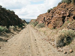
border. The Chicago, Milwaukee, St. Paul and Pacific Railroad right-of-way was acquired by Washington state, through a quitclaim deed, and is used as a non-motorized recreational trail managed by the Washington State Parks and Recreation Commission and by the Washington State Department of Natural Resources. State legislation "railbanked" (also called Rails-to-trails) the corridor with provisions that allow for the reversion to rail usage in the future. The 100 miles (160.9 km) portion from Cedar Falls (near North Bend) to the Columbia River
Columbia River
The Columbia River is the largest river in the Pacific Northwest region of North America. The river rises in the Rocky Mountains of British Columbia, Canada, flows northwest and then south into the U.S. state of Washington, then turns west to form most of the border between Washington and the state...
just south of Vantage
Vantage, Washington
Vantage is a census-designated place in Kittitas County, Washington, United States. The population was 70 at the 2000 census.-History:The area around Vantage has been occupied by the Wanapum Native Americans since prehistory. A number of well-preserved rock-paintings have been found on the cliff...
has been developed and is managed as the Iron Horse State Park
Iron Horse State Park
Iron Horse State Park, part of the Washington State Park System, is a state park located in the Cascade Mountains and Yakima River Valley, between Cedar Falls on the west and the Columbia River on the east....
. A State Parks concessionaire operates a commercial hike-bike shuttle bus (http://www.busup90.com) between Cedar Falls and Hyak during summer months. This section lies in King County
King County, Washington
King County is a county located in the U.S. state of Washington. The population in the 2010 census was 1,931,249. King is the most populous county in Washington, and the 14th most populous in the United States....
and Kittitas County.
Crossing the Columbia River at the Beverly Railroad Bridge
Beverly Railroad Bridge
The Beverly Railroad Bridge was constructed by the Chicago, Milwaukee, St. Paul and Pacific Railroad in 1909 during its Pacific Extension...
at Beverly
Beverly, Washington
Beverly, Washington is a small community along the banks of the Columbia River in central Washington state. The community, which consists of a few hundred residents, is just a few miles downriver from Wanapum Dam and is nestled at the base of what locals call Sentinel Gap, a huge basalt formation...
, south of Vantage, the trail continues through undeveloped sections of the park in eastern Washington. From the trailhead at Beverly it proceeds along Crab Creek
Crab Creek
Crab Creek is a stream in the U.S. state of Washington. Named for the presence of crayfish, it is one of the few perennial streams in the Columbia Basin of central Washington, flowing from the northeastern Columbia River Plateau, roughly east of Reardan, west-southwest to empty into the Columbia...
and eastward. It intersects the Columbia Plateau Trail
Columbia Plateau Trail
The Columbia Plateau Trail is a -long -wide corridor in eastern Washington State along the abandoned right-of-way of the former Spokane, Portland and Seattle Railway. It runs between Cheney, Washington and Pasco at the confluence of the Snake River and Columbia River. It passes through parts of...
between Lamont
Lamont, Washington
Lamont is a town in Whitman County, Washington, United States. The population was 70 at the 2010 census.-History:Lamont was named for former vice president of the Northern Pacific Railroad, Daniel Lamont. Lamont was officially incorporated on October 22, 1910.-Historical population:Population...
and Benge
Benge, Washington
Benge is an unincorporated community in Adams County, Washington, United States. Because it is not tracked by the U.S. Census, a Census population estimate is not available. Benge is assigned the ZIP code 99105...
, and continues thru Malden to Tekoa
Tekoa, Washington
Tekoa is a city in Whitman County, Washington, United States. The population was 778 at the 2010 census.-History:Tekoa was first settled in 1886 by David A. Huffman and George T. Huffman. The townsite was platted in 1888 and was named after the Biblical town.Tekoa was incorporated in 1889 with...
near the Idaho border. This section lies in Grant, Adams, Whitman
Whitman County, Washington
Whitman County is a county located in the U.S. state of Washington. As of the 2010 census, the population was 44,776, with the majority living in its largest city, Pullman, home to Washington State University, the state's land-grant university. The county seat is at Colfax.Whitman County was...
, and Spokane
Spokane County, Washington
Spokane County is a county located in the U.S. state of Washington, named after the Spokane tribe. As of the 2010 census the population was 471,221, making it the fourth most populous county in Washington state. The largest city and county seat is Spokane, the second largest city in the state,...
Counties.
Iron Horse Park Access
Access points to the developed portion of the trail, managed by Washington State Parks and Recreation Commission, are at:- Rattlesnake LakeRattlesnake LakeRattlesnake Lake is a lake in King County, Washington, located in Rattlesnake Mountain Scenic Area some east of Seattle.-History:The town of Moncton existed in 1906–1915 around the northern edge of Rattlesnake Lake. In the spring of 1915 it was destroyed by flooding caused by seepage of water from...
, Cedar Falls - western terminus and connection to the Snoqualmie Valley Regional TrailSnoqualmie Valley Regional TrailThe Snoqualmie Valley Regional Trail is a King County administered trail that connects with the John Wayne Pioneer Trail in Iron Horse State Park. The trail follows a portion of the former alignment of the Chicago, Milwaukee, St... - Twin Falls
- HyakHyak, WashingtonHyak is an unincorporated community located on Snoqualmie Pass in Kittitas County, Washington.Hyak was established around 1915 at the eastern portal of the Snoqualmie Pass Milwaukee Road Railroad tunnel. Originally a train station, the community began to grow in the 1930s when the railroad built a...
- provides access the 2.3- mile long Snoqualmie Tunnel (scheduled to reopen July 1, 2011) through the crest of the Cascade Mountains. Currently, tunnels 46 through 50 — from Thorp, in Kittitas County, westward to Snoqualmie Pass are closed until further notice (this includes the 2.3-mile long Snoqualmie Tunnel which reopened in the Summer of 2011). - EastonEaston, WashingtonEaston is a census-designated place in Kittitas County, Washington, United States. The population was 478 at the 2010 census.-History:Easton was platted in 1902...
- descending the eastern slope of the Cascades - Cle ElumCle Elum, WashingtonCle Elum is a city in Kittitas County, Washington, United States. The population was 1,872 at the 2010 census. Only an hour and a half's drive from Seattle, Cle Elum is a popular area for camping and outdoor activities.-Early years and industries:...
- provides access to the Upper Yakima RiverYakima RiverThe Yakima River is a tributary of the Columbia River in south central and eastern Washington State, named for the indigenous Yakama people. The length of the river from headwaters to mouth is , with an average drop of .-Course:...
Canyon - ThorpThorp, WashingtonThorp is an unincorporated town and census-designated place in Kittitas County, Washington, United States. The population was 240 at the 2010 census...
- near the historic Thorp Mill - Thorp, WashingtonThorp, WashingtonThorp is an unincorporated town and census-designated place in Kittitas County, Washington, United States. The population was 240 at the 2010 census...
- in the open farm valley of the Yakima River drainage east of Ellensburg, WashingtonEllensburg, WashingtonEllensburg is a city in, and the county seat of, Kittitas County, Washington, United States. The population was 18,174 at the 2010 census. The population was 18,250 at 2011 Estimate from Office of Financial Management. Ellensburg is located just east of the Cascade Range on I-90 and is known as the... - Army West - at the western edge of the stretch passing through the shrub-steppeShrub-steppeShrub-steppe is a type of low rainfall natural grassland. Shrub-steppes are distinguishable from deserts, which are too dry to support a noticeable cover of perennial grasses or other shrubs, while the shrub-steppe has sufficient moisture levels to support a cover of perennial grasses and/or...
country of the U.S. Army's Yakima Training CenterYakima Training CenterThe Yakima Training Center is a United States Army training center located in south central Washington state. It is bounded on the west by Interstate 82, on the south by the city of Yakima, on the north by the city of Ellensburg and Interstate 90, and on the east by the Columbia River... - Army East - at the eastern edge of the stretch passing through the shrub-steppe country of the U.S. Army's Yakima Training Center as it reaches the Columbia RiverColumbia RiverThe Columbia River is the largest river in the Pacific Northwest region of North America. The river rises in the Rocky Mountains of British Columbia, Canada, flows northwest and then south into the U.S. state of Washington, then turns west to form most of the border between Washington and the state...
Undeveloped Sections Access
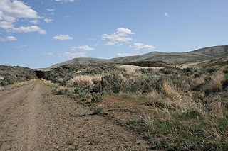
Access points to the undeveloped portion of the trail, managed by Washington State Department of Natural Resources, have not been formally opened to the public. However the trail provides access to the unique geological erosion features of the Channeled ScablandsChanneled scablands
The Channeled Scablands are a unique geological erosion feature in the U.S. state of Washington. They were created by the cataclysmic Missoula Floods that swept periodically across eastern Washington and down the Columbia River Plateau during the Pleistocene epoch. Geologist J Harlen Bretz coined...
regions of Washington state
U.S. state
A U.S. state is any one of the 50 federated states of the United States of America that share sovereignty with the federal government. Because of this shared sovereignty, an American is a citizen both of the federal entity and of his or her state of domicile. Four states use the official title of...
, and several streteches have been recognized as providing access to this area created by the cataclysm
Cataclysm
The term cataclysm The term cataclysm The term cataclysm (from the Greek kataklysmos, to 'wash down' (kluzein "wash" + kata "down") may refer to:*Deluge (mythology)*a hypothetical Doomsday event*any catastrophic geological phenomenon**volcanic eruption**earthquake...
ic Missoula Floods
Missoula Floods
The Missoula Floods refer to the cataclysmic floods that swept periodically across eastern Washington and down the Columbia River Gorge at the end of the last ice age. The glacial flood events have been researched since the 1920s...
that swept periodically across eastern Washington and down the Columbia River Plateau
Columbia River Plateau
The Columbia Plateau is a geologic and geographic region that lies across parts of the U.S. states of Washington, Oregon, and Idaho. It is a wide flood basalt plateau between the Cascade Range and the Rocky Mountains, cut through by the Columbia River...
during the Pleistocene epoch
Pleistocene
The Pleistocene is the epoch from 2,588,000 to 11,700 years BP that spans the world's recent period of repeated glaciations. The name pleistocene is derived from the Greek and ....
. At Malden Washington, once home to the largest railroad turntable in the world, the Parks Department is planning a trailhead in the former rail yard.. A private developer has also floated the idea of an equestrian fiendly camp ground with pull-thru parking and horse corrals. The Malden Library and Community Center, located two blocks off the trail, has public restrooms with showers for trail users. Horse parking is available.