
Janakpur Zone
Encyclopedia
Janakpur Zone
Janakpur Zone ' onMouseout='HidePop("95384")' href="/topics/Zones_of_Nepal">zones
of Nepal
, reaching from the India
n border in the south to the Tibet
an border in the north and Sagarmatha zone
in east and Bagmati
and Naryani
zones in west.
The headquarters of Janakpur zone and its main city is Janakpur. Close to the Indian border, it is a historic city of Hinduism
. The city was believed to be the capital city of the King Janak, the father in law of Lord Rama
, the son of the then King of Ayodhya, Dasharatha. The city was then called 'Mithila Nagari'. The name of this zone is related to the historic king Janak and his capital Janakpur.
Other cities of Janakpur zone are Kamalamai
(in Inner Tarai
) and Bhimeshwor
and Bardibas
, Dhalkebar, Jaleshwor, Malangwa, and Matihani (outer Terai).
Janakpur Zone ' onMouseout='HidePop("95384")' href="/topics/Zones_of_Nepal">zones
Zones of Nepal
Nepal is divided into 14 administrative zones , and 75 districts . The 14 administrative zones are grouped into five development regions...
of Nepal
Nepal
Nepal , officially the Federal Democratic Republic of Nepal, is a landlocked sovereign state located in South Asia. It is located in the Himalayas and bordered to the north by the People's Republic of China, and to the south, east, and west by the Republic of India...
, reaching from the India
India
India , officially the Republic of India , is a country in South Asia. It is the seventh-largest country by geographical area, the second-most populous country with over 1.2 billion people, and the most populous democracy in the world...
n border in the south to the Tibet
Tibet
Tibet is a plateau region in Asia, north-east of the Himalayas. It is the traditional homeland of the Tibetan people as well as some other ethnic groups such as Monpas, Qiang, and Lhobas, and is now also inhabited by considerable numbers of Han and Hui people...
an border in the north and Sagarmatha zone
Sagarmatha Zone
Sagarmāthā zone in the north, hill districts in the center, and valley districts of the Terai in the south. The borders of this zone are China to the north, India to the south, the Koshi Zone to the east and the Janakpur Zone to the west....
in east and Bagmati
Bagmati Zone
Bagmati Zone Bagmati is divided into eight districts:- See also :*Zones of Nepal*Regions of Nepal*Districts of Nepal...
and Naryani
Narayani Zone
- Geography :Narayani contains parts of the Terai, Inner Terai, and Hill regions of Nepal, but it does not contain any of the Mountain or Himalayan region. Narayani is rich in flora and fauna...
zones in west.
The headquarters of Janakpur zone and its main city is Janakpur. Close to the Indian border, it is a historic city of Hinduism
Hinduism
Hinduism is the predominant and indigenous religious tradition of the Indian Subcontinent. Hinduism is known to its followers as , amongst many other expressions...
. The city was believed to be the capital city of the King Janak, the father in law of Lord Rama
Rama
Rama or full name Ramachandra is considered to be the seventh avatar of Vishnu in Hinduism, and a king of Ayodhya in ancient Indian...
, the son of the then King of Ayodhya, Dasharatha. The city was then called 'Mithila Nagari'. The name of this zone is related to the historic king Janak and his capital Janakpur.
Other cities of Janakpur zone are Kamalamai
Kamalamai
Kamalamai is a municipality in Sindhuli District, in the Janakpur zone of central south Nepal. At the time of the 1991 Nepal census it had a population of 32,838 people....
(in Inner Tarai
Inner Terai Valleys of Nepal
The Inner Terai Valleys or Bhitri tarai are various elongated valleys in Nepal situated between the Himalayan foothills, the 600–900 m high Siwalik or Churia Range and the 2,000-3,000 m high Mahabharat Range further north. Major examples are the Chitwan Valley southwest of Kathmandu and the...
) and Bhimeshwor
Bhimeshwor
Bhimeshwor is a village development committee in Sindhuli District in the Janakpur Zone of south-eastern Nepal. At the time of the 1991 Nepal census it had a population of 1855 people living in 326 individual households.-External links:*...
and Bardibas
Bardibas
Bardibas is a village development committee in Mahottari District in the Janakpur Zone of south-eastern Nepal. At the time of the 1991 Nepal census it had a population of 6049 people living in 1090 individual households.-Transport:...
, Dhalkebar, Jaleshwor, Malangwa, and Matihani (outer Terai).
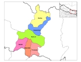
Districts
Janakpur is divided into six districts:- Dhanusa DistrictDhanusa DistrictDhanusa District of 671,364. It lies in the Central Development Region of Nepal. Also famous as a cultural center, the city attracts many Hindu pilgrims during festivals from both Nepal and India....
- Dholkha District
- Mahottari DistrictMahottari DistrictMahottari District of 553,481.Its headquarters is located in Jaleshwor, a neighbouring town of historical city, Janakpur. The name Jaleshwor means the 'God in Water'. One can find a famous temple of Lord Shiva in Water there...
- Ramechhap DistrictRamechhap DistrictRamechhap District of 212,408 and a density of 137.4 per km2. The district has the highest population of endangered native group Kusunda and has the lowest population growth rate in Nepal.-Etymology:...
- Sarlahi DistrictSarlahi District-Village Development Committees :*Achalgadh*Arnaha*Atrouli*Aurahi*Babarganj*Bagdaha*Bahadurpur*Balara*Bara Udhoran*Barahathawa*Basantapur*Batraul*Bela*Belhi*Belwajabdi*Bhadsar*Bhagawatipur*Bhaktipur*Bhawanipur*Brahmapuri*Chandra Nagar...
- Sindhuli DistrictSindhuli District-Historical Importance:This place has a huge historic significance. The Sindhuli Gadhi in Sindhuli is the place where British soldiers were defeated for the first time in Asia in 1767 A.D . The British under the leadership of Captain Kinloch came to help the then ruler of Kathmandu, Jai Prakash...
See also
- Zones of NepalZones of NepalNepal is divided into 14 administrative zones , and 75 districts . The 14 administrative zones are grouped into five development regions...
- Districts of NepalDistricts of NepalNepal's 14 administrative zones are subdivided into 75 districts . These districts are listed below, by zone...
- Regions of NepalRegions of NepalNepal is divided into 14 administrative zones , which are divided into 75 districts . The 14 administrative zones are grouped into five development regions...