
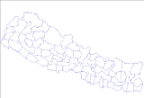
Districts of Nepal
Encyclopedia

Nepal
Nepal , officially the Federal Democratic Republic of Nepal, is a landlocked sovereign state located in South Asia. It is located in the Himalayas and bordered to the north by the People's Republic of China, and to the south, east, and west by the Republic of India...
's 14 administrative zones
Zones of Nepal
Nepal is divided into 14 administrative zones , and 75 districts . The 14 administrative zones are grouped into five development regions...
(Nepali: अञ्चल; ancal) are subdivided into 75 districts (Nepali:जिल्ला; jillā). These districts are listed below, by zone. District headquarters are in parentheses.
Bagmati ZoneBagmati ZoneBagmati Zone Bagmati is divided into eight districts:- See also :*Zones of Nepal*Regions of Nepal*Districts of Nepal...
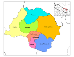
- Bhaktapur DistrictBhaktapur DistrictBhaktapur district, located in the eastern part of Kathmandu valley, is the smallest among the seventy-five districts of Nepal. The district, with Bhaktapur as its district headquarters, covers an area of 119 km² and has a population of 225,461....
(BhaktapurBhaktapurBhaktapur , also Bhadgaon or Khwopa is an ancient Newar town in the east corner of the Kathmandu Valley, Nepal. It is located in Bhaktapur District in the Bagmati Zone...
) - Dhading DistrictDhading District-Geography:The district spreads from 27'40" E to 28'17" E and 80'17"N to 84'35"N. The mountain range "Ganesh" is the predominate mountain range located within Dhading. Some of the peaks are over 7,000 meters. The 8,000+ meter mountain "Manaslu" is clearly visible from much of Dhading, although it...
(Dhading BesiDhading BesiDhading besi is a district headquarter of the Dhading District in Nepal. The word besi in the Nepali language means lowlands, the reason many people settled here. It is a small town situated along the banks of two rivers, Arung and Thopal khola...
) - Kathmandu DistrictKathmandu DistrictKathmandu District is a district located in Kathmandu Valley, Bagmati Zone of Nepal, a landlocked country in South Asia. It is one of the seventy-five districts of Nepal, covers an area of 395 km2 and is the most densely populated district of Nepal with a population of 1,081,845 in 2001...
(Kathmandu) - Kavrepalanchok DistrictKavrepalanchok District-Towns and villages:Anaikot Balathali Balting Baluwa Baluwapatti Deupur Banakhu Chor Banepa Batase Bekhsimle Bhimkhori Bhumidanda Bhumlutar Birtadeurali Bolde Fediche Budhakhani Chalal Ganeshsthan Chandeni Mandan Choubas Chyamrangbesi...
(DhulikhelDhulikhelDhulikhel is the administrative centre of Kavrepalanchok District, Nepal. At the time of the 1991 Nepal census it had a population of 9812 people in 1624 households. Dhulikhel lies along the B.P. Highway and Arniko Highway. Arniko Highway connects Kathmandu, Nepal's capital city with Tibet's...
) - Lalitpur DistrictLalitpur District, NepalLalitpur District of 337,785. It is one of the three districts in the Kathmandu Valley, along with Kathmandu and Bhaktapur.Lalitpur District has many schools, colleges and hotels. Adarsha Vidya Mandir, St. Xavier's School, St...
(Patan) - Nuwakot DistrictNuwakot DistrictNuwakot District of 288,478.The district contains places of historical significance such as Nuwakot Palace located in the village of Nuwakot and Devighat located at the confluence of the Tadi and Trishuli Rivers.-Towns and villages:...
(BidurBidurBidur is the capital of Nuwakot District in Bagmati Zone, Nepal. At the time of the 1991 Nepal census it had a population of 18694 and had 3736 houses in it.In February 2008 terrorists damaged the town's water supply plant....
) - Rasuwa DistrictRasuwa DistrictRasuwa District of 44,731.Gosaikunda lake is located in the district.-Village Development Committees :*Bhorle*Briddhim*Chilime*Dandagaun*Dhaibung*Dhunche*Gatlang*Goljung*Haku*Jibjibe*Khamjim*Laharepauwa*Langtang*Ramche*Saramthali...
(DhuncheDhuncheDhunche is the capital of Rasuwa District in Bagmati Zone, Nepal. It is located at at an altitude of . At the time of the 2001 Nepal census it had a population of 2,535 people residing in 604 individual households....
) - Sindhupalchok District (ChautaraChautaraChautara is a village in Sindhupalchok District in the Bagmati Zone of central Nepal. At the time of the 1991 Nepal census it had a population of 3734 and had 782 houses in the village....
)
Bheri ZoneBheri ZoneBheri Anchal in the Mid-Western Development Region of Nepal. Nepalgunj is the administrative headquarters.Cities and towns are Narayan, Jajarkot and Chhinchu in the "hills"; Nepalgunj, Gularia and Kohalpur in Terai; Birendranagar in Surkhet Valley in the Inner Terai.Bheri Zone is divided into five...
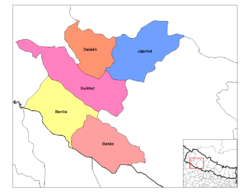
- Banke DistrictBanke District-Geography:Banke is bordered on the west by Bardiya district. Rapti zone's Salyan and Dang Deukhuri Districts border to the north and east. To the south lies Uttar Pradesh, India; specifically Shravasti and Bahraich districts of Awadh. East of Nepalganj the international border follows the...
(NepalgunjNepalgunjNepalgunj , also spelled Nepalganj, is a municipality in Banke District, Nepal on the Terai plains near the southern border with Bahraich district, Uttar Pradesh state of India. It is 16 km south of Kohalpur and the east-west Mahendra Highway....
) - Bardiya DistrictBardiya DistrictBardiya DistrictBardiya DistrictBardiya DistrictBardiya DistrictBardiya DistrictBardiya DistrictBardiya DistrictBardiya DistrictBardiya District
- Dailekh District
Dailekh District-Village Development Committees :*Awal Parajul*Bada Bhairab*Bada Khola*Badalamji*Baluwatar*Bansi*Baraha*Basantamala*Belaspur*Belpata*Bhawani*Bindhyabasini*Bisalla*Chamunda*Chauratha*Dada Parajul*Dullu*Gamaudi*Gauri*Goganpani*Jaganath...
(DulluDulluDullu is a village development committee in Dailekh District in the Bheri Zone of western-central Nepal. At the time of the 1991 Nepal census it had a population of 3330 people living in 688 individual households...
)- Jajarkot District
Jajarkot DistrictJajarkot District of 134,868.Jajarkotis one of the district of Bheri Zone in Mid-western Region of Nepal. Khalanga is its headquarter...
(KhalangaKhalanga, JajarkotKhalanga, Jajarkot is a village development committee in Jajarkot District in the Bheri Zone of mid-western Nepal. At the time of the 1991 Nepal census it had a population of 8140 living in 1533 individual households.-External links:*...
)- Surkhet District
Surkhet District-Village Development Committees :*Agragaun*Awalaching*Babiyachaur*Bajedichaur*Betan*Bidyapur*Bijaura*Birendranagar*Chapre*Chhinchu*Dahachaur*Dandakhali*Dasarathpur*Dharapani*Gadi...
(BirendranagarBirendranagarBirendranagar is a city in mid western Nepal, located in the Surkhet District of Bheri Zone. At the time of the 1991 Nepal census it had a population of 22,937 people residing in 4773 individual households....
)
Dhawalagiri Zone
Dhawalagiri ZoneDhawalagiri is one of the fourteen zones of Nepal. It comes under the Western division of Nepal. Baglung is the headquarters of this zone. Famous trekking areas like Mustang, Muktinath, Kali Gandaki valley and Mt Dhaulagiri fall in this zone...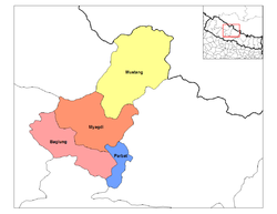
- Baglung DistrictBaglung DistrictBaglung District, of 268,938.Baglung is surrounded by Parvat, Myagdi, Rukum, Ropla, Pyuthan and Gulmi districts. It looks like Nepal in shape. It has 59 Village Development Committees and one Municipality. It has many rivers and streams and so, many suspension bridges. Baglung is also known as the...
(KalikaBaglungBaglung, is a town in western Nepal, 275 km west of Kathmandu. It is the administrative headquarters of Baglung District and Dhawalagiri Zone. Baglung is a major business, financial, educational, and healthcare center for the people of Kali Gandaki valley....
) - Mustang DistrictMustang DistrictMustang District, a part of Dhawalagiri Zone, is one of the seventy-five districts of Nepal, a landlocked country of South Asia. The district, with Jomsom as its headquarters, covers an area of 3,573 km² and has a population of 14,981....
(JomsomJomsomJomsom , also known as Dzongsam or New Fort, is a town located at an altitude of 2800m in Mustang, Nepal. It extends over both the banks of the Kali Gandaki River. Along the banks of Kali Gandaki river there are rocks holy to the Hindus. The soaring peaks of Dhaulagiri and Nilgiri form a backdrop...
) - Myagdi DistrictMyagdi District-Village Development Committees :*Arman*Arthunge*Babiyachaur*Baranja*Begkhola*Bhakilmi*Bima*Chimkhola*Dagnam*Dana*Darwang*Devisthan*Dhatan*Dowa*Gurja Khani*Histhan Mandali*Jhin*Jyamrukot*Kuhunkot*Kuinemangale*Lulang*Malkwang*Marang*Mudi...
(Beni) - Parbat DistrictParbat DistrictParbat District of 157,826.It is mainly famous for the Gupteshowr Cave, which is visited by thousands of pilgrims during Shivaratri. It is also noted for the Dahere Deurali Temple, which is visited by thousands of pilgrims during Balachaturdanshai....
(KusmaKusma, NepalKusma is the headquarter of Parbat District, one of a district among 75 districts in Nepal, which lies in the western part of Nepal just about 57 Km away from one of a famous city of Nepal, Pokhara. Kusma falls under Western Development Region and Dhaoolagiri Zone of Nepal.It is located at...
)
Gandaki Zone
Gandaki ZoneThe Gandaki zone that make up the Gandaki River. Pokhara serves as its regional and zonal capital. It is also the birthplace of Bhanubhakta Acharya, first poet of Nepal.The Gandaki zone is home to multiple cultures which are unique in themselves...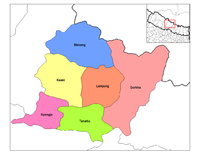
- Gorkha DistrictGorkha DistrictGorkha District of 288,134. It is the location of the Manakamana Temple. Also, the temples of great sage Gorakh Nath and goddess Gorakh Kali temple is located in district, after which the district got its name. Four major rivers run within and along it, they are Chepe, Daraudi, Marsyangdi and...
(Gorkha) - Kaski DistrictKaski DistrictKaski District of 380,527.The district covers parts of the Annapurna mountain range, and the picturesque scene of the mountains can be observed from most parts of the district...
(PokharaPokharaPokhara Sub-Metropolitan City is the second largest city of Nepal. Pokhara is city of close to 350,000 inhabitants in central Nepal located at 28.25°N, 83.99°E, which is the centre of the country from east to west or from north to south, 198 km west of Kathmandu or 90 km west of Mugling, and...
) - Lamjung DistrictLamjung DistrictLamjung District of 177,149. Lamjung mainly consists of agricultural villages. The picture on the right is a scene taken in a village called "Kapur Gaun". CHESS Nepal is based in Lamjung District.-Village Development Committees :*Archalebot...
(BesisaharBesisaharBesisahar is the capital of Lamjung District in Gandaki Zone, Nepal. CHESS Nepal is based in Besisahar. It is a start point of famous Annapurna Circuit tourist route....
) - Manang DistrictManang DistrictManang District of 9,587.The pass of Thorung La at 5415 meters above the sea connects the district to Mustang District by providing a route between the towns of Manang and Muktinath....
(ChameChame, NepalChame is the headquarters of Manang District in the Gandaki Zone of northern Nepal. At the time of the 1991 Nepal census it had a population of 1122 people living in 230 individual households. Manang District is the lowest populated district in Nepal....
) - Syangja DistrictSyangja DistrictSyangja District, a part of Gandaki Zone, is one of the seventy-five districts of Nepal, a landlocked country of South Asia. The district, with Syangja as its district headquarters, covers an area of 1,164 km² and has a population of 317,320. Syangja lies at the height of about 1088 meters ...
(SyangjaSyangjaSyangja is the headquarters of Syangja District in the Gandaki Zone of Nepal. It is located at 28°4'60N 83°52'0E with an altitude of 1088 metres .At the time of the 1991 Nepal census it had a population of 8914 people residing in 1884 individual households. -External links:**...
) - Tanahu DistrictTanahu DistrictTanahun District of 315,237. Previously the town of Bandipur was its district headquarters.-Coordinates & Location type:*Latitude: 27.91667*Longitude:84.25*Latitude :27° 55' 0 N*Longitude :84° 15' 0 E-Village Development Committees :...
(DamauliDamauliDamauli is the headquarters of Tanahu District in the Gandaki Zone of central Nepal. At the time of the 1991 Nepal census it had a population of 18,099 people residing in 3604 individual households...
)
Janakpur Zone
Janakpur ZoneJanakpur Zone The headquarters of Janakpur zone and its main city is Janakpur. Close to the Indian border, it is a historic city of Hinduism. The city was believed to be the capital city of the King Janak, the father in law of Lord Rama, the son of the then King of Ayodhya, Dasharatha. The city...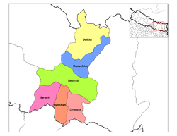
- Dhanusa DistrictDhanusa DistrictDhanusa District of 671,364. It lies in the Central Development Region of Nepal. Also famous as a cultural center, the city attracts many Hindu pilgrims during festivals from both Nepal and India....
(Janakpur) - Dolakha District (CharikotCharikotCharikot is the headquarters of Dolakha District in the Janakpur Zone of north-eastern Nepal. At the time of the 1991 Nepal census it had a population of 7349 people residing in 1541 individual households.. The town is located at and has an altitude of 1970 metres ....
) - Mahottari DistrictMahottari DistrictMahottari District of 553,481.Its headquarters is located in Jaleshwor, a neighbouring town of historical city, Janakpur. The name Jaleshwor means the 'God in Water'. One can find a famous temple of Lord Shiva in Water there...
(JalesworJalesworJaleswar is the headquarters of Mahottari District, Nepal. It is located at an altitude of 53 metres ....
) - Ramechhap DistrictRamechhap DistrictRamechhap District of 212,408 and a density of 137.4 per km2. The district has the highest population of endangered native group Kusunda and has the lowest population growth rate in Nepal.-Etymology:...
(ManthaliManthali, JanakpurManthali is a village development committee in Ramechhap District in the Janakpur Zone of north-eastern Nepal. At the time of the 1991 Nepal census it had a population of 3097 people living in 588 individual households.-External links:*...
) - Sarlahi DistrictSarlahi District-Village Development Committees :*Achalgadh*Arnaha*Atrouli*Aurahi*Babarganj*Bagdaha*Bahadurpur*Balara*Bara Udhoran*Barahathawa*Basantapur*Batraul*Bela*Belhi*Belwajabdi*Bhadsar*Bhagawatipur*Bhaktipur*Bhawanipur*Brahmapuri*Chandra Nagar...
(MalangwaMalangwaMalangawa or Malangwa is a town and municipality and the headquarters of Sarlahi District in the Janakpur Zone of Nepal. It is located at 26°52'0N 85°34'0E with an altitude of 79 metres near the border with India....
) - Sindhuli DistrictSindhuli District-Historical Importance:This place has a huge historic significance. The Sindhuli Gadhi in Sindhuli is the place where British soldiers were defeated for the first time in Asia in 1767 A.D . The British under the leadership of Captain Kinloch came to help the then ruler of Kathmandu, Jai Prakash...
(KamalamaiKamalamaiKamalamai is a municipality in Sindhuli District, in the Janakpur zone of central south Nepal. At the time of the 1991 Nepal census it had a population of 32,838 people....
)
Karnali Zone
Karnali ZoneKarnali Zone in the Mid-Western Development Region of Nepal. The headquarters is Jumla.Karnali Zone is one of the poorest and most remote regions of Nepal, not very accessible by road yet. There are airfields in all districts except Kalikot which is connected by seasonal roadways to Jumla...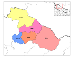
- Dolpa DistrictDolpa District-Geography:Dolpa is the largest district of Nepal covering 5.36% of the total landmass of the country. Located between 28°24’ N - 29°43’ N latitude, and 82°24’ E - 83°38’ E longitude, the elevation in Dolpa ranges from above sea level...
(Dunai) - Humla DistrictHumla DistrictHumla District of 40,595.The Northern part of Humla District is inhabited by Buddhists,originating from Tibet, whereas the South is mostly inhabited by Hindus.-Towns and villages:Bargaun,Chhipra,Dami,Dandafaya,Gothi,Hepka,Jaira,Kalika,Kermi,...
(SimikotSimikotSimikot is a mountainous town in the Himalayas of northwest Nepal, near the border with the Tibet Autonomous Region of China. It is the administrative headquarters of the Humla district in the Karnali Zone of Nepal....
) - Jumla DistrictJumla DistrictJumla District|Jumla]] as its district headquarters, covers an area of 2,531 km² and has a population of 89,427.The origin of Nepali language is Sinja of Jumla...
(Jumla KhalangaJumla (town)Jumla is the capital of the Jumla District in the Karnali Zone of Nepal, a landlocked country of Southeast Asia. The town is located at an altitude of 2514 metres .-Geography:...
) - Kalikot DistrictKalikot DistrictKalikot District of 105,580. In September 2005, in a bid to encourage a change in social attitudes, the government announced that it would provide rice to any family that had recently had a girl born.-Village Development Committees :*Badalkot*Chhapre...
(ManmaManmaManma is the capital of Kalikot District in Karnali Zone, Nepal, a landlocked country of South Asia. The town is located at 29°8'60N 81°37'0E and has an altitude of 2033 metres....
) - Mugu DistrictMugu DistrictMugu District of 43,937. The biggest lake in Nepal, Rara Lake, also known as Mahendra Daha, lies in the Mugu District.It is one of the biggest districts of Nepal.Pulu is one of the famous Village Development Committee of Mugu district...
(GamgadhiGamgadhiGamgadhi is the headquarters of Mugu District in the Karnali Zone of northern Nepal....
)
Koshi Zone
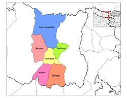
- Bhojpur District (BhojpurBhojpur, NepalBhojpur is a town in Eastern Nepal. It is the district headquarters of Bhojpur district, a hilly/mountainous district in Kosi Zone. At the time of the 1991 Nepal census it had a population of 5823 people living in 1199 households....
) - Dhankuta DistrictDhankuta DistrictDhankuta District , a part of Kosi Zone, is one of the seventy-five districts of Nepal, a landlocked country of South Asia. The district covers an area of 891 km² and has a population of 166,479., Dhankuta is the district headquarters and a major administrative region in the Eastern...
(DhankutaDhankutaDhankuta is a hill town of Nepal located along the geographical coordinates- 26° 59' 0" N / 87° 20' 0" E, with about 20,000 inhabitants, located in the Dhankuta District in the eastern part of Nepal. Until about 1963 Dhankuta Bazaar was the administrative headquarters for the whole of...
) - Morang DistrictMorang DistrictMorang District , a part of Kosi Zone, is one of the seventy-five districts of Nepal, a landlocked country of South Asia. The district, with Biratnagar as its district headquarters, covers an area of 1,855 km² and has a population of 843,220....
(Biratnagar) - Sankhuwasabha DistrictSankhuwasabha DistrictSankhuwasabha District of 159,203.Indigenous ethnics Yakkhas, Rais, Limbus, and other hill castes and ethnic groups Sankhuwasabha District of 159,203.Indigenous ethnics Yakkhas, Rais, Limbus, and other hill castes (e.g. Chhetri, Bahuns) and ethnic groups Sankhuwasabha District of...
(KhandbariKhandbariKhandbari is the district headquarters of Sankhuwasabha District in the Kosi Zone of north-eastern Nepal. At the time of the 1991 Nepal census it had a population of 21,789....
) - Sunsari DistrictSunsari DistrictSunsari District of 625,633.The area was originally part of Morang but became its own district in 1962 when Nepal was divided into 14 zones and 75 districts....
(Inaruwa) - Terhathum DistrictTerhathum DistrictTerhathum District of 113,111. The word Tehrathum is constructed from thirteen and "thum" . This can be spelled as Terathum, Tehrathum or Terhathum. The town supposedly is the site of one of a series of guard posts once protecting the territory of the Limbus...
(MyanglungMyanglungMyanglung is a town and district headquarters of Terhathum District in the Kosi Zone of Nepal. In December 2002 the bazaar of Myanglung was hit by fire, 211 families were affected when 85 shops were gutted.-References:...
)
Lumbini Zone
Lumbini ZoneLumbini Zone, is one of the 14 zones of Nepal and is home to Lumbini site, the birthplace of Siddhartha Gautama, who later became the historical Buddha and founder of the Buddhist philosophy...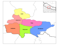
- Arghakhanchi DistrictArghakhanchi DistrictArghakhanchi is one of the districts of Lumbini Zone in Nepal's Western Development Region. The district headquarters are Sandhikharka.-Etymology:...
(SandhikharkaSandhikharkaSandhikharka is the headquarters of Arghakhanchi District in the Lumbini Zone of Nepal. It is located in a remote area of central Nepal, 380 km southwest of Nepal's capital of Kathmandu. Due to a high literacy rate, Sandhikharka once attracted people from outside Arghakhanchi District to...
) - Gulmi DistrictGulmi DistrictGulmi District of 296,654. It is famous for coffee farming. Ruru, a Holy Place now also known as Ridi,is a market centre,where many of the tamples are situated.Maghe sankranti and other festivals are celebrated here. Many local as well as foreign tourists come here to visit the place...
(TamghasTamghasTamghas, also Gulmi Tamghas or Tamghas Bazaar is a town and the headquarters of Gulmi District, Nepal. It is located at 28°4'0N 83°15'0E with an altitude of 1838 metres . As of 2001 it had a population of 10, 680...
) - Kapilvastu DistrictKapilvastu DistrictKapilvastu district of 481,976.-Geography:The district situated at the height of 93 to 1491 meters from sea level. Geographically, the district can be divided into plain low lands of terai and low Chure hills.Kapilvastu is bounded by-...
(KapilvastuTaulihawaKapilvastu , formerly Taulihawa, is a municipality and seat of Kapilvastu District in the Lumbini Zone of southern Nepal. The city is located within the historical Kapilvastu area. At the time of the 2001 Nepal census it had a population of 27,170 people...
) - Nawalparasi DistrictNawalparasi DistrictNawalparasi District of 562,870. This district has given birth to many Nepal's top level people including late Prime Minister Tanka Prasad Acharya...
(ParasiParasi, NepalParasi is a town and municipality and seat of Nawalparasi District in the Lumbini Zone of southern Nepal. At the time of the 1991 Nepal census it had a population of 22,630....
) - Palpa DistrictPalpa District-Village Development Committee :*Archale*Argali*Bahadurpur*Bakamalang*Baldengadhi*Bandi Pokhara*Barangdi old name archale barangdi name came from barandi khola on the bank of this river the famous rani mahal is situated*Bhairabsthan*Bhuwan...
(TansenTansen, NepalTansen is a Municipality and the administrative center of Palpa District in the "hllls" of western Nepal. It is located on the highway between Butwal and Pokhara, on the crest of the Mahabharat Range or Lesser Himalaya overlooking the valley of the Kaligandaki River to the north...
) - Rupandehi DistrictRupandehi District-Village Development Committees :*Aama*Aanandaban*Amari*Amawa Marchawar*Amuwa Paschim*Asurena*Babhani*Bagaha*Bagauli*Bairghat*Balarampur*Bangai*Bangai Marchwar*Baragadewa*Barsauli*Basantapur*Betakuiya*Bhagawanpur*Bisunpura*Bodabar*Bogadi...
(SiddharthanagarSiddharthanagarThis article is on the Nepali town. For the district in Uttar Pradesh, see Siddharthnagar District.Siddharthanagar is a municipality near the Indian border on the Outer Terai plains of Nepal, west of Kathmandu Nepal's capital...
)
Mahakali Zone
Mahakali ZoneMahakali|Kali River]] or Mahakali River, which originates from Kalapani.Mahakali's headquarter is Mahendranagar in Kanchanpur District. The zone covers the Himalayan range including Api Peak in the North, Hill valleys, Inner Terai valleys such as Patan in Baitadi District in the center and the...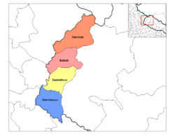
- Baitadi DistrictBaitadi DistrictBaitadi district , historical name “Bairath” , a part of Mahakali zone, is one of the seventy-five districts of Nepal, a landlocked country of South Asia. The district, with Baitadi as its district headquarters, covers an area of 1,519 km² and has a population of 234,418. The Baitadi...
(Baitadi) - Dadeldhura DistrictDadeldhura DistrictDadeldhura district, a part of Mahakali zone, is one of the seventy-five districts of Nepal, a landlocked country of South Asia. The district, with Dadeldhura as its district headquarters, covers an area of 1,538km² and has a population of 126,162....
(DadeldhuraDadeldhuraDadeldhura is a Village Development Committee in Dadeldhura District in the Mahakali Zone of western Nepal.-External links:*...
) - Darchula DistrictDarchula DistrictDarchula District of 121,996.The town has an Indian counterpart to its northwest, named Dharchula. The split between the two towns is just virtual as the traditions, culture, and lifestyle of the people living across both the regions are quite similar....
(Darchula) - Kanchanpur DistrictKanchanpur District-Basic statistics:* District: Kanchanpur* Headquarters: Mahendranagar* Area: 1610 km²* Total Population: 377,899* Literacy rate: 57.60% -Political divisions:* Political constituencies: 4...
(Bhim Dutta)
Mechi Zone
Mechi ZoneMechi and other ethnic groups like Koche and Meche, and hill castes like Bahun and Chhetris.Mechi is divided into four districts:*Ilam District*Jhapa District*Panchthar District*Taplejung District...
- Ilam DistrictIlam DistrictIlam district of 282,806. It is about 600 km from Kathmandu. The highest point is Sandakpur with an elevation of 3000m. Ilam attracts many researchers who come to study rare birds and the Red Panda...
(IlamIlam, NepalIlam is a municipality and tea-producing town in Nepal. It is in Ilam District which is in hilly Eastern Region of Nepal. It is famous for natural scenery and landscapes, tea production, and diverse agricultural economy.-Tea Production:...
) - Jhapa DistrictJhapa DistrictJhapa District, a district of Mechi Zone, is one of the seventy-five districts of Nepal. The district, with Chandragadhi as its district headquarters, covers an area of 1,606 km² and has a population of 688,109.-Location:...
(ChandragadhiChandragadhiChandragadhi is a town and municipality and district headquarters of Jhapa District in the Mechi Zone of south-eastern Nepal. At the time of the 1991 Nepal census it had a population of 12,259 people living in 2345 individual households....
) - Panchthar DistrictPanchthar DistrictPanchthar District of 202,056. Panchthar's majority population is that of Kirantis and other ethnic groups and hill castes.-Village Development Committees :*Aangna*Aangsarang*Aarubote*Ambarpur*Bharapa*Chilingdin*Chokmagu...
(PhidimPhidimPhidim is a village development committee in Panchthar District in the Mechi Zone of eastern Nepal. At the time of the 1991 Nepal census it had a population of 6518 people living in 1423 individual households....
) - Taplejung DistrictTaplejung DistrictTaplejung District of 134,698.The name Taplejung is derived from the words "Taple" and "Jung". Taple was the medieval Limbu King who used to rule the area and "Jung" in Limbu language means Fort. Literally, Taplejung means Fort of King Taple....
(TaplejungTaplejungTaplejung is the headquarters of Taplejung District in the Mechi Zone of Nepal. It is located at 27°21'0N 87°40'0E with an altitude of 1441 metres ....
)
Narayani Zone
Narayani Zone- Geography :Narayani contains parts of the Terai, Inner Terai, and Hill regions of Nepal, but it does not contain any of the Mountain or Himalayan region. Narayani is rich in flora and fauna...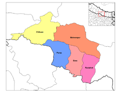
- Bara DistrictBara DistrictBara District of 559,135. Pasaha, Dudhaura and Bangari are the main rivers of Bara. Gamahariya is one of the villages of Bara District which is situated near the border area of India....
(KalaiyaKalaiyaKalaiya is a town and capital of Bara District in the Narayani Zone of south-eastern Nepal. At the time of the 1991 Nepal census it had a population of 18,498 persons residing in 3010 individual households....
) - Chitwan DistrictChitwan DistrictChitwan District and one sub-Metropolitan city - Bharatpur and a municipality Ratnanagar each of which has more than nine wards or urban areas....
(BharatpurBharatpur, NepalBharatpur is a city in the central-southern part of Nepal. Located in Chitwan Valley, Bharatpur is the district headquarters of the Chitwan District, as well as a separate Municipal authority, and is the seventh largest city of Nepal with the population of 89,323 . The estimated population for...
) - Makwanpur DistrictMakwanpur DistrictMakwanpur District of 392,604. Bhimfedi market of the district was the traditional route to enter Kathmandu valley from the south.-Village Development Committees :*Agara*Ambhanjyang*Bajrabarahi*Basamadi*Betini*Bhaise*Bharta Pundyadevi*Bhimfedi...
(HetaudaHetaudaHetauda is a town in the Makwanpur District of the Narayani Zone in southern Nepal. It is also the administrative headquarters of the Makwanpur district. At the time of the 1991 Nepal census it had a population of 53,836 people living in 10,420 individual households...
) - Parsa DistrictParsa District-Village Development Committees :*Alau*Amarpatti*Auraha*Bagahi*Bagbana*Bageswori*Bahauri Pidari*Bahurbamatha*Basadilwa*Basantpur*Belwa Parsouni*Beriya Birta*Bhawanipur*Bhedihari*Bhisawa*Bijbaniya*Bindabasini*Biranchibarba*Birganj...
(BirganjBirganjBirganj is a sub-metropolitan municipality and border town in Parsa District in the Narayani Zone of southern Nepal. It lies 283 km south of the capital Kathmandu, 3 km north of the border of the Indian state of Bihar. As an entry point to Nepal from Patna and Calcutta it is also known...
) - Rautahat DistrictRautahat District-Village Development Committees :*Ajagabi*Akolawa*Auraiya*Badharwa*Bagahi*Bahuwa Madanpur*Bairiya*Banjaraha*Bariyarpur*Basantapatti*Basatpur*Basbiti Jingadiya*Bhalohiya*Bhediyahi*Birtipraskota*Bishrampur*Bisunpurwa Manpur*Brahmapuri...
(GaurGaur, NepalGaur is a town in the Rautahat district, a part of Narayani zone, in Madhes Nepal. Gaur is close to the border with India.On March 21, 2007, supporters of the Madhesi People's Rights Forum clashed with supporters of Maoist resulting in death of 29 people, mostly of Maoist...
)
Rapti Zone
Rapti ZoneRapti Anchal in the Mid-Western Development Region of Nepal. It is named after the West Rapti River which drains Rolpa, Pyuthan and part of Dang district. The remainder of Dang and part of Salyan are drained by the Babai. The remainder of Salyan and all of Rukum are drained by the Bheri.The...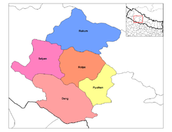
- Dang Deukhuri District (Tribuvannagar)
- Pyuthan DistrictPyuthan DistrictPyuthan District of 212,484. Pyuthan Khalanga is the district's administrative center.-Geography:Pyuthan borders Dang Deukhuri District to the southwest along the crest of the Mahabharat Range and extends about 50 km northeast through the Middle Hills to a 3,000+ meter ridge that is both...
(Pyuthan Khalanga) - Rolpa DistrictRolpa DistrictRolpa of 210,004. Livang is the district's administrative center.By Nepalese standards, Rolpa is an underdeveloped area plagued by low life expectancy and poverty . It was a major flashpoint in the 1996-2006 Civil War.Adjoining districts are Dang to the south, Pyuthan to the east, Salyan to the...
(Liwang) - Rukum DistrictRukum DistrictRukum District of 188,438. Musikot is the district's administrative center.Rukum district has many potential tourist attractions that remain unexplored. There is 5,849 meter Mt. Sisne , also called virgin mountain. Nobody claims to have conquered this mountain yet. Rukum is also called "the...
(MusikotMusikotMusikot is the headquarters of Rukum District in Rapti Zone of central Nepal. At the time of the 2001 Nepal census it had a population of 7,279 persons living in 1,474 individual households....
) - Salyan DistrictSalyan DistrictSalyan District of 213,500. The district's administrative center is named Salyan or Salyan Khalanga.The district is known for its Hindu temples including Shiva temples in Chhayachhetra and Laxmipur, and the Devi temple at Khairabang in Hiwalcha VDC, one of nine in Nepal...
(Salyan KhalangaSalyan, NepalSalyan or Salyan Khalanga is the headquarters of Salyan District in the mid-west 'hills' of Nepal. It is located at 28°22'31N 82°9'42E at 1530 metres elevation ....
)
Sagarmatha Zone
Sagarmatha ZoneSagarmāthā zone in the north, hill districts in the center, and valley districts of the Terai in the south. The borders of this zone are China to the north, India to the south, the Koshi Zone to the east and the Janakpur Zone to the west....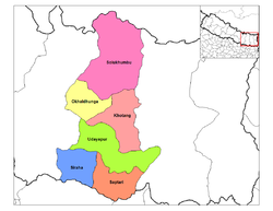
- Khotang DistrictKhotang DistrictKhotang District, a part of Sagarmatha Zone, is one of the seventy-five districts of Nepal, a landlocked country of South Asia. The district, with Diktel as its district headquarters, covers an area of 1,591 km² and has a population of 231,385. Khotang is part of the area traditionally called...
(DiktelDiktelDiktel is the headquarters of Khotang District, a part of Sagarmatha Zone, Nepal. At the time of the 1991 Nepal census it had a population of 7,324 persons residing in 1,433 individual households....
) - Okhaldhunga DistrictOkhaldhunga DistrictOkhaldhunga District of 156,702.Okhaldhunga is part of area traditionally called Wallo Kirat,home to indigenous ethnic groups Rai and Sunuwar...
(Okhaldhunga) - Saptari DistrictSaptari DistrictSaptari District of 570,282. Saptari is renowned for its agricultural output, and is bordered on the east by the massive Sapt Koshi river.Significant towns are Rajbiraj, the district centre, Hanumannagar, and Fattepur with the area government "Matsya Palan Kendra" fish farm.The famous Chhinna...
(RajbirajRajbirajRajbiraj, a mid-sized town in south-eastern Nepal, 16 kilometers north of the Indian border. It is the administrative headquarters of the Saptari district. It has an airfield with flights to Kathmandu. The government planned to convert the airport to an international airport but the program is...
) - Siraha DistrictSiraha District-Village Development Committees :*Arnama Lalpur*Arnama Rampur*Asanpur*Ashokpur Balkawa*Aurahi*Ayodhyanagar*Badharamal*Barchhawa*Bariyarpatti*Basbita*Bastipur*Belaha*Belhi*Betauna*Bhadaiya*Bhagawanpur*Bhagawatipur*Bhawanipur...
(SirahaSirahaSiraha Nepal is the headquarters of Siraha District, a part of Sagarmatha Zone, Nepal. The town is located at an altitude of 64 metres .It has the population of 572,399 according to the statistics of 2001.It is not event the town or the cities,a small BAZAAR.The political condition is not well of...
) - Solukhumbu DistrictSolukhumbu DistrictSolukhumbu District of 107,686.Mount Everest is located in the northern part of this district, within Sagarmatha National Park.Indigenous ethnic Rai and hill Caste Chhetri are the main groups living in the mid-hills, while Sherpas occupy high mountains....
(Salleri) - Udayapur DistrictUdayapur District-Village Development Committees :*Aaptar*Balamta*Baraha*Barre*Basabote*Bashasa*Beltar*Bhumarashuwa*Bhuttar*Chaudandi*Dumre*Gaighat*Hadiya*Hardeni*Iname*Jalpachilaune*Jante*Jogidaha*Katari*Katunjebawala*Khanbu*Laphagaun*Lekhani*Lekhgaun...
(GaighatGaighatGaighat is a town in east Nepal. It is situated in a valley and surrounded by the Chure Hills. Many different ethnic groups and castes live in Gaighat, following their old traditions and speaking many languages. As a trade focal point of the Udayapur District, this place has an emerging number...
)
Seti Zone
Seti ZoneSeti ZoneSeti ZoneSeti ZoneSeti ZoneSeti ZoneSeti ZoneSeti ZoneSeti ZoneSeti Zone' onMouseout='HidePop("13704")' href="/topics/Achham_District">Achham DistrictAchham DistrictAchham District,, a part of Seti Zone, is one of the seventy-five districts of Nepal, a landlocked country of South Asia. The district, with Mangalsen as its district headquarters, covers an area of 1,692 km² and has a population of 231,285. It is one of the remotest districts of Nepal...
(MangalsenMangalsenMangalsen is a town and capital Achham District in the Seti Zone of western Nepal. At the time of the 1991 Nepal census it had a population of 7,185 and had 1404 houses in the village....
)- Bajhang District
Bajhang District-Towns and villages:Banjh,Bhairab Nath,Bhamchaur,Bhatekhola,Byasi,Chaudhari,Dahabagar,Dangaji,Dantola,Daulichaur,Deulekh,Deulikot,Dhamena,Gadaraya,Hemantabada,Kadal,Kailash,Kalukheti,Kanda,Kaphalaseri,Khiratadi,Koiralakot,Kot Bhairab,Kotdewal,...
(ChainpurChainpur, SetiChainpur is a town and seat of Bajhang District in the Seti Zone of north-western Nepal. At the time of the 1991 Nepal census it had a population of 4,143 and had 759 houses in the village. It has a grass runway in town with limited flights...
)- Bajura District
Bajura District-Towns and villages:Atichaur,Baddhu,Wai,Barhabise,Bichhiya,Bramhatola,Budhiganga,Chhatara,Dahakot,Dogadi,Gotree,Gudukhati,Jagannath,Jayabageswori,Jugada,Kailashmandau,Kanda,Kolti,Kotila,Kuldeumadau,Manakot,Martadi,Pandusain,Rugin,Sappata,...
(MartadiMartadiMartadi is a town and seat of Bajura District in the Seti Zone of north-western Nepal. At the time of the 1991 Nepal census it had a population of 4,618 and had 942 houses in the town....
)- Doti District
Doti District-History:Doti was a medieval kingdom of Nepal founded by Niranjan Malla Deo, the younger brother of Abhay Pal of Askot. Rulers of Doti were called 'Raika'...
(Dipayal)- Kailali District
Kailali DistrictKailali District of 616,697. Dhangadhi is a center of attraction of not only Kailali district but of the whole seti zone. The district also contains Tikapur Park, one of the biggest parks in Nepal, and Godha-Ghodi Tal lake.-Towns and villages:Baliya...
(DhangadhiDhangadhiDhangadhi is a city in Far western Nepal bordering India. It is the capital of Kailali District in the province of Seti.Located in the Far Western Region of Nepal on the border of India, the city of Dhangadhi is one of the entry points into the country for people traveling from India.It was...
)
External links
- Dailekh District