
Interstate 85 in South Carolina
Encyclopedia
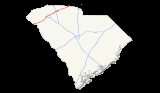
In the U.S. state
of South Carolina
, Interstate 85
runs northeast-southwest through Greenville and Spartanburg. It follows the general corridor of U.S. Route 29
. In 1964, I-85
became the first South Carolina
Interstate
highway to have its originally planned mileage completed.
 In South Carolina
, Interstate 85 crosses Lake Hartwell
at several points before bypassing Anderson
on the way to Greenville
. Beginning at Anderson, I-85 widens from four to six lanes. Near Powdersville, U.S. 29 joins I-85 and they run concurrently until they cross the Saluda River
.
 Interstate 85 bypasses Greenville, but provides a link into the city via spur routes Interstates 185
and 385
. U.S. 29 splits from I-85 and joins I-185 toward downtown Greenville. I-185 recently saw a major expansion south of the city as the Southern Connector was completed.
Two key Upstate businesses can be seen from this portion of the interstate. One is Michelin Tires's North American headquarters and the other is the BMW
plant, located in Greer
. I-85 also passes Greenville-Spartanburg International Airport
, which serves the Greenville-Spartanburg metropolitan area.
, I-85 bypasses the city to the north. Its original route is now designated Business Loop 85
and was approved by AASHTO on April 22, 1995.
North of Spartanburg, I-85 narrows from six lanes back to four lanes and bypasses Gaffney
. At Gaffney, motorists can see The Peachoid
, a large water tower with its top shaped like a peach
, representing one of the state's most important crops.
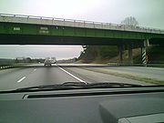
Most of the terrain between Spartanburg and the North Carolina border is rural in nature.
!County
!Location
!#
!Destinations
!Notes
|-
|rowspan=3|Oconee
|
|1
|
|
|-
|
|2
|
|
|-
|
|4
|
|
|-
|rowspan=10|Anderson
|rowspan=7|Anderson
|11
|
|
|-
|14
|
|
|-
|19
|
|Signed as exits 19A (east) and 19B (west)
|-
|21
|
|
|-
|27
|
|
|-
|32
|
|
|-
|34
|
|South end of US 29 overlap
|-
|
|35
|
|
|-
|rowspan=2|Easley
|39
|River Road – Easley
|
|-
|40
|
|
|-
|rowspan=11|Greenville
|
|42
|
|North end of US 29 overlap
|-
|rowspan=8|Greenville
|44A
|
|
|-
|44B
|
|
|-
|46A
|Augusta Road
|
|-
|46B
|
|
|-
|46C
|Mauldin Road
|
|-
|48
|
|Signed as exits 48A (east) and 48B (west)
|-
|51A
|
|
|-
|51
|
|Signed as exits 51B (south) and 51C (north)
|-
|
|54
|Pelham Road
|
|-
|rowspan=4|Greer
|56
|
|
|-
|rowspan=14|Spartanburg
|57
|Aviation Drive – GSP International Airport
|
|-
|58
|Brockman McClimon Road
|
|-
|60
|
|
|-
|
|63
|
|
|-
|
|66
|
|
|-
|
|68
|
|
|-
|
|69
|
|
|-
|rowspan=3|Spartanburg
|70
|, Asheville
|Signed as exits 70A (east) and 70B (west)
|-
|72
|
|Signed as exits 72A (south) and 72B (north)
|-
|75
|
|
|-
|
|77
|
|
|-
|
|78
|
|
|-
|
|80
|Road 57, Gossett Road
|
|-
|
|83
|
|
|-
|rowspan=10|Cherokee
|
|87
|Road 39
|
|-
|rowspan=2|Gaffney
|90
|
|
|-
|92
|
|
|-
|
|95
|Road 82 – Gaffney
|
|-
|
|96
|, Shelby
|
|-
|
|98
|Frontage Road
|Northbound exit only
|-
|
|100
|Blacksburg Highway
|
|-
|Blacksburg
|102
|
|
|-
|
|104
|Road 99
|
|-
|
|106
|, Grover
|
U.S. state
A U.S. state is any one of the 50 federated states of the United States of America that share sovereignty with the federal government. Because of this shared sovereignty, an American is a citizen both of the federal entity and of his or her state of domicile. Four states use the official title of...
of South Carolina
South Carolina
South Carolina is a state in the Deep South of the United States that borders Georgia to the south, North Carolina to the north, and the Atlantic Ocean to the east. Originally part of the Province of Carolina, the Province of South Carolina was one of the 13 colonies that declared independence...
, Interstate 85
Interstate 85
Interstate 85 is a major interstate highway in the Southeastern United States. Its current southern terminus is at an interchange with Interstate 65 in Montgomery, Alabama; its northern terminus interchanges with Interstate 95 in Petersburg, Virginia, near Richmond...
runs northeast-southwest through Greenville and Spartanburg. It follows the general corridor of U.S. Route 29
U.S. Route 29
U.S. Route 29 is a north–south United States highway that runs for from the western suburbs of Baltimore, Maryland, to Pensacola, Florida. This highway's northern terminus is at Maryland Route 99 in Ellicott City, Maryland...
. In 1964, I-85
Interstate 85
Interstate 85 is a major interstate highway in the Southeastern United States. Its current southern terminus is at an interchange with Interstate 65 in Montgomery, Alabama; its northern terminus interchanges with Interstate 95 in Petersburg, Virginia, near Richmond...
became the first South Carolina
South Carolina
South Carolina is a state in the Deep South of the United States that borders Georgia to the south, North Carolina to the north, and the Atlantic Ocean to the east. Originally part of the Province of Carolina, the Province of South Carolina was one of the 13 colonies that declared independence...
Interstate
Interstate Highway System
The Dwight D. Eisenhower National System of Interstate and Defense Highways, , is a network of limited-access roads including freeways, highways, and expressways forming part of the National Highway System of the United States of America...
highway to have its originally planned mileage completed.
Georgia state line to Greenville
South Carolina
South Carolina is a state in the Deep South of the United States that borders Georgia to the south, North Carolina to the north, and the Atlantic Ocean to the east. Originally part of the Province of Carolina, the Province of South Carolina was one of the 13 colonies that declared independence...
, Interstate 85 crosses Lake Hartwell
Lake Hartwell
Lake Hartwell is a reservoir bordering Georgia and South Carolina on the Savannah, Tugaloo, and Seneca Rivers. The lake is created by Hartwell Dam located on the Savannah River seven miles below the point at which the Tugaloo and Seneca Rivers join to form the Savannah...
at several points before bypassing Anderson
Anderson, South Carolina
Anderson is a city in and the county seat of Anderson County, South Carolina, United States. The population was estimated at 26,242 in 2006, and the city was the center of an urbanized area of 70,530...
on the way to Greenville
Greenville, South Carolina
-Law and government:The city of Greenville adopted the Council-Manager form of municipal government in 1976.-History:The area was part of the Cherokee Nation's protected grounds after the Treaty of 1763, which ended the French and Indian War. No White man was allowed to enter, though some families...
. Beginning at Anderson, I-85 widens from four to six lanes. Near Powdersville, U.S. 29 joins I-85 and they run concurrently until they cross the Saluda River
Saluda River
The Saluda River is a principal tributary of the Congaree River, about 200 mi long, in northern and western South Carolina in the United States...
.
Greenville to Spartanburg
Interstate 185 (South Carolina)
Interstate 185 is located in the city of Greenville, South Carolina. The northern portion, which ends just shy of the Greenville city limits, was opened in the 1960s and is cosigned with U.S. 29. The southern portion, which connects the I-85/I-185 interchange with the I-385/U.S. 276 interchange ,...
and 385
Interstate 385
Interstate 385 starts where it meets the Interstate 26, near Clinton and heads in a northwest direction where it ends with exit 42, near downtown Greenville. After exit 42, I-385 turns into Business Spur 385 that then promptly ends at U.S. 29 near the Bi-Lo Center in downtown Greenville. It is one...
. U.S. 29 splits from I-85 and joins I-185 toward downtown Greenville. I-185 recently saw a major expansion south of the city as the Southern Connector was completed.
Two key Upstate businesses can be seen from this portion of the interstate. One is Michelin Tires's North American headquarters and the other is the BMW
BMW
Bayerische Motoren Werke AG is a German automobile, motorcycle and engine manufacturing company founded in 1916. It also owns and produces the Mini marque, and is the parent company of Rolls-Royce Motor Cars. BMW produces motorcycles under BMW Motorrad and Husqvarna brands...
plant, located in Greer
Greer, South Carolina
Greer is a city in Greenville and Spartanburg counties in the U.S. state of South Carolina, between the cities of Greenville and Spartanburg. The population was 25,515 at the 2010 census. It is projected to hit 30,000 within 4 years. Each day, more than three times that number of people pass...
. I-85 also passes Greenville-Spartanburg International Airport
Greenville-Spartanburg International Airport
Greenville-Spartanburg International Airport , also known as GSP International Airport or Roger Milliken Field, is a public airport located in unincorporated Greenville and Spartanburg counties in South Carolina, United States, 3 miles south of central Greer; the airport serves Greenville and...
, which serves the Greenville-Spartanburg metropolitan area.
Spartanburg to North Carolina state line
Instead of going into SpartanburgSpartanburg, South Carolina
thgSpartanburg is the largest city in and the county seat of Spartanburg County, South Carolina, United States. It is the second-largest city of the three primary cities in the Upstate region of South Carolina, and is located northwest of Columbia, west of Charlotte, and about northeast of...
, I-85 bypasses the city to the north. Its original route is now designated Business Loop 85
Interstate 85 Business (Spartanburg, South Carolina)
Interstate 85 Business is a Business Loop of the Interstate Highway System and a freeway, running along the old route of Interstate 85 through Spartanburg, South Carolina, United States...
and was approved by AASHTO on April 22, 1995.
North of Spartanburg, I-85 narrows from six lanes back to four lanes and bypasses Gaffney
Gaffney, South Carolina
Gaffney is a city in and the county seat of Cherokee County, South Carolina, United States, in the upstate region of South Carolina. Gaffney is also sometimes referred to as the Peach capital of South Carolina. The population was 12,414 at the 2010 census...
. At Gaffney, motorists can see The Peachoid
Peachoid
The Peachoid is a four-story water tower in Gaffney, South Carolina, United States, that resembles a peach. The water tower holds one million gallons of water and is located on Interstate 85 between exits 90 and 92...
, a large water tower with its top shaped like a peach
Peach
The peach tree is a deciduous tree growing to tall and 6 in. in diameter, belonging to the subfamily Prunoideae of the family Rosaceae. It bears an edible juicy fruit called a peach...
, representing one of the state's most important crops.
Most of the terrain between Spartanburg and the North Carolina border is rural in nature.
Auxiliary routes
.svg.png) Interstate 185Interstate 185 (South Carolina)Interstate 185 is located in the city of Greenville, South Carolina. The northern portion, which ends just shy of the Greenville city limits, was opened in the 1960s and is cosigned with U.S. 29. The southern portion, which connects the I-85/I-185 interchange with the I-385/U.S. 276 interchange ,...
Interstate 185Interstate 185 (South Carolina)Interstate 185 is located in the city of Greenville, South Carolina. The northern portion, which ends just shy of the Greenville city limits, was opened in the 1960s and is cosigned with U.S. 29. The southern portion, which connects the I-85/I-185 interchange with the I-385/U.S. 276 interchange ,...
is a spur into GreenvilleGreenville, South Carolina-Law and government:The city of Greenville adopted the Council-Manager form of municipal government in 1976.-History:The area was part of the Cherokee Nation's protected grounds after the Treaty of 1763, which ended the French and Indian War. No White man was allowed to enter, though some families...
from the southwest, and a later extension as a toll roadToll roadA toll road is a privately or publicly built road for which a driver pays a toll for use. Structures for which tolls are charged include toll bridges and toll tunnels. Non-toll roads are financed using other sources of revenue, most typically fuel tax or general tax funds...
to I-385 southeast of GreenvilleGreenville, South Carolina-Law and government:The city of Greenville adopted the Council-Manager form of municipal government in 1976.-History:The area was part of the Cherokee Nation's protected grounds after the Treaty of 1763, which ended the French and Indian War. No White man was allowed to enter, though some families...
..svg.png) Interstate 385Interstate 385Interstate 385 starts where it meets the Interstate 26, near Clinton and heads in a northwest direction where it ends with exit 42, near downtown Greenville. After exit 42, I-385 turns into Business Spur 385 that then promptly ends at U.S. 29 near the Bi-Lo Center in downtown Greenville. It is one...
Interstate 385Interstate 385Interstate 385 starts where it meets the Interstate 26, near Clinton and heads in a northwest direction where it ends with exit 42, near downtown Greenville. After exit 42, I-385 turns into Business Spur 385 that then promptly ends at U.S. 29 near the Bi-Lo Center in downtown Greenville. It is one...
is a spur into GreenvilleGreenville, South Carolina-Law and government:The city of Greenville adopted the Council-Manager form of municipal government in 1976.-History:The area was part of the Cherokee Nation's protected grounds after the Treaty of 1763, which ended the French and Indian War. No White man was allowed to enter, though some families...
from the east, and a later extension southeast to Interstate 26Interstate 26 in South CarolinaInterstate 26 is a South Carolina Interstate highway running generally east–west to U.S. Route 17 in the Atlantic Coast at Charleston, South Carolina to Landrum in Spartanburg County.-Route description:...
towards ColumbiaColumbia, South CarolinaColumbia is the state capital and largest city in the U.S. state of South Carolina. The population was 129,272 according to the 2010 census. Columbia is the county seat of Richland County, but a portion of the city extends into neighboring Lexington County. The city is the center of a metropolitan...
..svg.png) Interstate 585Interstate 585Interstate 585 stretches from Interstate 85 to Spartanburg, South Carolina. I-585 is co-signed the entire length with U.S. Highway 176 and it uses US 176's exit number system instead of its own. Between exits 23 and 25B the road is a freeway but has substandard or no shoulders. To the south of...
Interstate 585Interstate 585Interstate 585 stretches from Interstate 85 to Spartanburg, South Carolina. I-585 is co-signed the entire length with U.S. Highway 176 and it uses US 176's exit number system instead of its own. Between exits 23 and 25B the road is a freeway but has substandard or no shoulders. To the south of...
is a spur from Interstate 85 BusinessInterstate 85 Business (Spartanburg, South Carolina)Interstate 85 Business is a Business Loop of the Interstate Highway System and a freeway, running along the old route of Interstate 85 through Spartanburg, South Carolina, United States...
into SpartanburgSpartanburg, South CarolinathgSpartanburg is the largest city in and the county seat of Spartanburg County, South Carolina, United States. It is the second-largest city of the three primary cities in the Upstate region of South Carolina, and is located northwest of Columbia, west of Charlotte, and about northeast of...
from the northwest. It does not connect directly to I-85 or any other Interstate.
Business Route
 Business Loop 85Interstate 85 Business (Spartanburg, South Carolina)Interstate 85 Business is a Business Loop of the Interstate Highway System and a freeway, running along the old route of Interstate 85 through Spartanburg, South Carolina, United States...
is a business Interstate route in SpartanburgSpartanburg, South CarolinathgSpartanburg is the largest city in and the county seat of Spartanburg County, South Carolina, United States. It is the second-largest city of the three primary cities in the Upstate region of South Carolina, and is located northwest of Columbia, west of Charlotte, and about northeast of...
.
Exit list
{|class="wikitable"!County
!Location
!#
Exit number
An exit number is a number assigned to a road junction, usually an exit from a freeway. It is usually marked on the same sign as the destinations of the exit, as well as a sign in the gore....
!Destinations
!Notes
|-
|rowspan=3|Oconee
|
|1
|
|
|-
|
|2
|
|
|-
|
|4
|
|
|-
|rowspan=10|Anderson
Anderson County, South Carolina
-Demographics:As of the census of 2010, there were 187,126 people and 70,597 households residing in the county. The population density was 260.6 people per square mile . There were 84,092 housing units...
|rowspan=7|Anderson
Anderson, South Carolina
Anderson is a city in and the county seat of Anderson County, South Carolina, United States. The population was estimated at 26,242 in 2006, and the city was the center of an urbanized area of 70,530...
|11
|
|
|-
|14
|
|
|-
|19
|
|Signed as exits 19A (east) and 19B (west)
|-
|21
|
|
|-
|27
|
|
|-
|32
|
|
|-
|34
|
|South end of US 29 overlap
|-
|
|35
|
|
|-
|rowspan=2|Easley
Easley, South Carolina
Easley is a city in Pickens County in the U.S. state of South Carolina. It is a principal city of the Greenville–Mauldin–Easley Metropolitan Statistical Area. Most of the city lies in Pickens County, with only a very small portion of the city in Anderson County...
|39
|River Road – Easley
Easley, South Carolina
Easley is a city in Pickens County in the U.S. state of South Carolina. It is a principal city of the Greenville–Mauldin–Easley Metropolitan Statistical Area. Most of the city lies in Pickens County, with only a very small portion of the city in Anderson County...
|
|-
|40
|
|
|-
|rowspan=11|Greenville
Greenville County, South Carolina
- External Links :*...
|
|42
|
|North end of US 29 overlap
|-
|rowspan=8|Greenville
Greenville, South Carolina
-Law and government:The city of Greenville adopted the Council-Manager form of municipal government in 1976.-History:The area was part of the Cherokee Nation's protected grounds after the Treaty of 1763, which ended the French and Indian War. No White man was allowed to enter, though some families...
|44A
|
|
|-
|44B
|
|
|-
|46A
|Augusta Road
|
|-
|46B
|
|
|-
|46C
|Mauldin Road
|
|-
|48
|
|Signed as exits 48A (east) and 48B (west)
|-
|51A
|
|
|-
|51
|
|Signed as exits 51B (south) and 51C (north)
|-
|
|54
|Pelham Road
|
|-
|rowspan=4|Greer
Greer, South Carolina
Greer is a city in Greenville and Spartanburg counties in the U.S. state of South Carolina, between the cities of Greenville and Spartanburg. The population was 25,515 at the 2010 census. It is projected to hit 30,000 within 4 years. Each day, more than three times that number of people pass...
|56
|
|
|-
|rowspan=14|Spartanburg
|57
|Aviation Drive –
GSP International AirportGreenville-Spartanburg International Airport
Greenville-Spartanburg International Airport , also known as GSP International Airport or Roger Milliken Field, is a public airport located in unincorporated Greenville and Spartanburg counties in South Carolina, United States, 3 miles south of central Greer; the airport serves Greenville and...
|
|-
|58
|Brockman McClimon Road
|
|-
|60
|
|
|-
|
|63
|
|
|-
|
|66
|
|
|-
|
|68
|
|
|-
|
|69
|
|
|-
|rowspan=3|Spartanburg
Spartanburg, South Carolina
thgSpartanburg is the largest city in and the county seat of Spartanburg County, South Carolina, United States. It is the second-largest city of the three primary cities in the Upstate region of South Carolina, and is located northwest of Columbia, west of Charlotte, and about northeast of...
|70
|, Asheville
Asheville, North Carolina
Asheville is a city in and the county seat of Buncombe County, North Carolina, United States. It is the largest city in Western North Carolina, and the 11th largest city in North Carolina. The City is home to the United States National Climatic Data Center , which is the world's largest active...
|Signed as exits 70A (east) and 70B (west)
|-
|72
|
|Signed as exits 72A (south) and 72B (north)
|-
|75
|
|
|-
|
|77
|
|
|-
|
|78
|
|
|-
|
|80
|Road 57, Gossett Road
|
|-
|
|83
|
|
|-
|rowspan=10|Cherokee
Cherokee County, South Carolina
Cherokee County is a county located in the U.S. state of South Carolina. The county was formed in 1897 from parts of York, Union, and Spartanburg Counties. It is included in the Gaffney, South Carolina Micropolitan Statistical Area. According to the 2010 United States Census, the county's...
|
|87
|Road 39
|
|-
|rowspan=2|Gaffney
Gaffney, South Carolina
Gaffney is a city in and the county seat of Cherokee County, South Carolina, United States, in the upstate region of South Carolina. Gaffney is also sometimes referred to as the Peach capital of South Carolina. The population was 12,414 at the 2010 census...
|90
|
|
|-
|92
|
|
|-
|
|95
|Road 82 – Gaffney
Gaffney, South Carolina
Gaffney is a city in and the county seat of Cherokee County, South Carolina, United States, in the upstate region of South Carolina. Gaffney is also sometimes referred to as the Peach capital of South Carolina. The population was 12,414 at the 2010 census...
|
|-
|
|96
|, Shelby
Shelby, North Carolina
Shelby is a city in Cleveland County, North Carolina, United States. The population was 19,477 at the 2000 census. It is the county seat of Cleveland County.-Geography:Shelby is located at ....
|
|-
|
|98
|Frontage Road
|Northbound exit only
|-
|
|100
|Blacksburg Highway
|
|-
|Blacksburg
Blacksburg, South Carolina
Blacksburg is a town in Cherokee County, South Carolina, United States. The population was 1,848 at the 2010 census. The communities of Cherokee Falls, Kings Creek, Cashion Crossroads, Buffalo, and Mt...
|102
|
|
|-
|
|104
|Road 99
|
|-
|
|106
|, Grover
Grover, North Carolina
Grover is a town in Cleveland County, North Carolina, United States. The population was 698 at the 2000 census.-History:Grover is classified a small town where railway and highway routes 85 and 29 cross the state line between North Carolina and South Carolina. It was previously named Whitaker and...
|