
Interstate 385
Encyclopedia
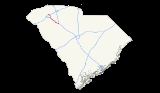
Interstate 385 starts where it meets the Interstate 26, near Clinton and heads in a northwest direction where it ends with exit 42, near downtown Greenville. After exit 42, I-385 turns into Business Spur 385 that then promptly ends at U.S. 29 near the Bi-Lo Center
in downtown Greenville. It is one of five official Interstate business spurs in S.C. (the others being spurs of I-20, I-126, I-526, and I-585).
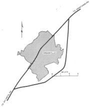 The general idea — but none of the specifics — of I-385 were present on the 1955 Yellow Book map of the Greenville
area. Also of note is that Interstate 85
would have used the U.S. Route 29 corridor from Greenville east towards Spartanburg based on the diagram.
The portion of I-385 that replaced U.S. 276 (from SC-417 in Mauldin to SC-56 / I-26 in Clinton) was initially the first phase built of an SC DOT plan that predated the Interstate System to upgrade and bypass existing through routes, the goal of forming a single limited-access highway from Greenville to the port of Charleston
via the State Capital of Columbia
. This plan was scrapped as soon as the future I-26
was added to the act of Congress that set into motion the Interstate System. As a result, I-26 was one of the first Interstates in the south to open in significant mileage (most in SC between 1959 and 1963).
Prior to 1985, I-385 was only signed as such from downtown Greenville to I-85. The portion of the freeway from U.S. 276 in Mauldin to the southern terminus at I-26 was signed as U.S. 276. When the connecting portion was completed, the entire freeway was signed as I-385.
For seven months ending July 23, 2010, northbound traffic could not use a 15-mile section of I-385 in Laurens County due to a $60.9 million project to pave the portion extending from highway 101
to the I-385-I-26
interchange near Clinton, SC in concrete. The closing of a major highway generated controversy.
Bi-Lo Center
The BI-LO Center is an arena located in downtown Greenville, South Carolina, that is used for concerts, football, and hockey. The arena is currently used by the Greenville Force of the Southern Indoor Football League and the Greenville Road Warriors of the ECHL.- History :The BI-LO Center was...
in downtown Greenville. It is one of five official Interstate business spurs in S.C. (the others being spurs of I-20, I-126, I-526, and I-585).
History
Greenville, South Carolina
-Law and government:The city of Greenville adopted the Council-Manager form of municipal government in 1976.-History:The area was part of the Cherokee Nation's protected grounds after the Treaty of 1763, which ended the French and Indian War. No White man was allowed to enter, though some families...
area. Also of note is that Interstate 85
Interstate 85 in South Carolina
In the U.S. state of South Carolina, Interstate 85 runs northeast-southwest through Greenville and Spartanburg. It follows the general corridor of U.S. Route 29...
would have used the U.S. Route 29 corridor from Greenville east towards Spartanburg based on the diagram.
The portion of I-385 that replaced U.S. 276 (from SC-417 in Mauldin to SC-56 / I-26 in Clinton) was initially the first phase built of an SC DOT plan that predated the Interstate System to upgrade and bypass existing through routes, the goal of forming a single limited-access highway from Greenville to the port of Charleston
Charleston, South Carolina
Charleston is the second largest city in the U.S. state of South Carolina. It was made the county seat of Charleston County in 1901 when Charleston County was founded. The city's original name was Charles Towne in 1670, and it moved to its present location from a location on the west bank of the...
via the State Capital of Columbia
Columbia, South Carolina
Columbia is the state capital and largest city in the U.S. state of South Carolina. The population was 129,272 according to the 2010 census. Columbia is the county seat of Richland County, but a portion of the city extends into neighboring Lexington County. The city is the center of a metropolitan...
. This plan was scrapped as soon as the future I-26
Interstate 26
Interstate 26 is a nominally east–west main route of the Interstate Highway System in the Southeastern United States. I-26 runs from the junction of U.S. Route 11W and U.S. Route 23 in Kingsport, Tennessee, generally southeastward to U.S. Route 17 in Charleston, South Carolina...
was added to the act of Congress that set into motion the Interstate System. As a result, I-26 was one of the first Interstates in the south to open in significant mileage (most in SC between 1959 and 1963).
Prior to 1985, I-385 was only signed as such from downtown Greenville to I-85. The portion of the freeway from U.S. 276 in Mauldin to the southern terminus at I-26 was signed as U.S. 276. When the connecting portion was completed, the entire freeway was signed as I-385.
For seven months ending July 23, 2010, northbound traffic could not use a 15-mile section of I-385 in Laurens County due to a $60.9 million project to pave the portion extending from highway 101
Highway 101
Highway 101 is an American country music band founded by Paulette Carlson , Jack Daniels , Curtis Stone and Scott "Cactus" Moser . With Carlson as lead vocalist, the band recorded three albums for Warner Bros. Records Nashville and charted ten consecutive Top Ten hits on the Hot Country Songs...
to the I-385-I-26
Interstate 26
Interstate 26 is a nominally east–west main route of the Interstate Highway System in the Southeastern United States. I-26 runs from the junction of U.S. Route 11W and U.S. Route 23 in Kingsport, Tennessee, generally southeastward to U.S. Route 17 in Charleston, South Carolina...
interchange near Clinton, SC in concrete. The closing of a major highway generated controversy.
Exit list
| County | Location | # Exit number An exit number is a number assigned to a road junction, usually an exit from a freeway. It is usually marked on the same sign as the destinations of the exit, as well as a sign in the gore.... |
Destinations | Notes |
|---|---|---|---|---|
| Laurens | Clinton Clinton, South Carolina Clinton is a city in Laurens County, South Carolina, United States. The population was 8,091 at the 2000 census. It is part of the Greenville–Mauldin–Easley Metropolitan Statistical Area. Clinton was first settled by Scots-Irish immigrants two decades before the American Revolutionary... |
1 | Southern terminus | |
| 2 | Northbound signed SC 308 only | |||
| Laurens Laurens, South Carolina Laurens is a city in Laurens County, South Carolina, United States. The population was 9,916 at the 2000 census. It is the county seat of Laurens County.-History:... |
5 | |||
| 9 | ||||
| Gray Court Gray Court, South Carolina Gray Court is a town in Laurens County, South Carolina, United States. The population was 1,021 at the 2000 census. It is part of the Greenville–Mauldin–Easley Metropolitan Statistical Area.-Geography:... |
10 | Metric Road – Gray Court Gray Court, South Carolina Gray Court is a town in Laurens County, South Carolina, United States. The population was 1,021 at the 2000 census. It is part of the Greenville–Mauldin–Easley Metropolitan Statistical Area.-Geography:... |
||
| 16 | ||||
| 19 | South end of SC 14 overlap | |||
| Fountain Inn Fountain Inn, South Carolina Fountain Inn is a city in Greenville and Laurens counties in the U.S. state of South Carolina. The population was 6,017 at the 2000 census. It is part of the Greenville–Mauldin–Easley Metropolitan Statistical Area.-Geography:... |
22 | North end of SC 14 overlap | ||
| Greenville Greenville County, South Carolina - External Links :*... |
23 | |||
| 24 | Fairview Street – Fountain Inn Fountain Inn, South Carolina Fountain Inn is a city in Greenville and Laurens counties in the U.S. state of South Carolina. The population was 6,017 at the 2000 census. It is part of the Greenville–Mauldin–Easley Metropolitan Statistical Area.-Geography:... |
|||
| 26 | Harrison Bridge Road | Southbound exit and entrance | ||
| Simpsonville Simpsonville, South Carolina Simpsonville is a city in Greenville County, South Carolina, United States. It is part of the Greenville–Mauldin–Easley Metropolitan Statistical Area. The population was 14,352 at the 2000 census, and estimated at 17,778 in 2009... |
27 | Fairview Road – Simpsonville Simpsonville, South Carolina Simpsonville is a city in Greenville County, South Carolina, United States. It is part of the Greenville–Mauldin–Easley Metropolitan Statistical Area. The population was 14,352 at the 2000 census, and estimated at 17,778 in 2009... |
||
| 29 | Georgia Road – Simpsonville Simpsonville, South Carolina Simpsonville is a city in Greenville County, South Carolina, United States. It is part of the Greenville–Mauldin–Easley Metropolitan Statistical Area. The population was 14,352 at the 2000 census, and estimated at 17,778 in 2009... |
|||
| Mauldin Mauldin, South Carolina Mauldin is a city in Greenville County, South Carolina, United States. The population was 15,224 at the 2000 census. It is a principal city of the Greenville–Mauldin–Easley Metropolitan Statistical Area.-Geography:... |
30 | |||
| 31 | No southbound exit; southbound exit is via exit 30 | |||
| 33 | Bridges Road – Mauldin Mauldin, South Carolina Mauldin is a city in Greenville County, South Carolina, United States. The population was 15,224 at the 2000 census. It is a principal city of the Greenville–Mauldin–Easley Metropolitan Statistical Area.-Geography:... |
|||
| 34 | Butler Road – Mauldin Mauldin, South Carolina Mauldin is a city in Greenville County, South Carolina, United States. The population was 15,224 at the 2000 census. It is a principal city of the Greenville–Mauldin–Easley Metropolitan Statistical Area.-Geography:... |
|||
| 35 | ||||
| Greenville Greenville, South Carolina -Law and government:The city of Greenville adopted the Council-Manager form of municipal government in 1976.-History:The area was part of the Cherokee Nation's protected grounds after the Treaty of 1763, which ended the French and Indian War. No White man was allowed to enter, though some families... |
36 | Signed as exits 36A (north) and 36B (south) northbound Single exit 36 southbound |
||
| 37 | Roper Mountain Road | |||
| 39 | Haywood Road | |||
| 40 | Signed as exits 40A (south) and 40B (north) | |||
| 42 | ||||
| 44 | Bryce Avenue, North Street | Signed as exits 44A (east/north) and 44B (west/south) northbound | ||
| North Street north | Northern terminus |