
Interstate 77 in North Carolina
Encyclopedia
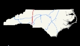
In the U.S. state
of North Carolina
, Interstate 77 (I-77) is a 106 miles (170.6 km) Interstate Highway
, which serves the city of Charlotte
and the Western Piedmont
.
 Interstate 77 begins at the South Carolina
state line, near Fort Mill
, in concurrency with US 21. I-77 goes through the city of Charlotte as a major north-south corridor, connecting the Center City
with the suburbs of Pineville
, Huntersville
, Cornelius
, and Davidson
. Between I-485
(exit 2) and I-277
(exit 9), the freeway is 6-lanes that typically experience slow traffic congestion during weekday rush hours (7:00-9:30 a.m./4:00-6:30 p.m.). Just north of Center City, I-77 makes a unique interchange configuration with Interstate 85
, with north and southbound lanes crisscrossing briefly. Between I-85 (exit 13) and I-485 (exit 19), I-77 features the state's only HOV
lanes. After I-485, I-77 reduces to 5-lanes (3 lanes northbound), then to 4-lanes after Gilead Road (exit 23).
At Lake Norman
, I-77 crosses into Iredell County
and becomes a more rural interstate, passing by Mooresville
and then Statesville
, where it intersects with Interstate 40
. After Statesville, I-77 becomes a full-fledged rural interstate, with only the town of Elkin
serving as a possible rest stop in the area; the speed limit of entire stretch is 70mph (110km/h). The final 5 miles (8 km) of I-77 is concurrent with Interstate 74
to the Virginia
state line (where I-74 ends), all within view of the Blue Ridge Mountains
.
(HOV) lanes in North Carolina, located in Mecklenburg County
. They are open 24-hour/7 days a week and are closed for general traffic unless otherwise posted. They are identified by a "diamond" symbol and overhead signs and are located on the leftmost lanes. Vehicles with two or more occupants can use the HOV lanes. Emergency vehicles when responding to emergencies, mass transit vehicles, privately-owned buses, and motorcycles may also use the lanes. Violators are subject to a fine of up to $100 plus court costs; two points against their driver's licenses for each HOV infraction.
in North Carolina when they were conveyed in 1956 by the then-North Carolina State Highway Commission. I-77 was added in 1957, increasing the state's mileage to 776 miles (1,248.8 km).
On August 4, 1959, the commission selected the routing of I-77 to run between Interstate 85
in Charlotte and a point on the Virginia border Elkin
. That would change in late 1960, when the commission voted to route the highway just west of Mount Airy
, saying the route would serve the most people.
With construction beginning in the 1960s, I-77 would gain additional mileage in October 1964 when a two-mile (3 km) extension was granted by the U.S. Bureau of Public Roads. Instead of ending at I-85, I-77 now ended at Independence Boulevard (U.S. 74
) in downtown Charlotte. Another extension was granted in the late 1960s that extended I-77 from Independence Boulevard to the South Carolina border. The latest extension also included a relocation of U.S. 21
from the city's surface streets to the new interstate.
I-77 opened to traffic in the following segments:
By 1972, I-77 was open from Exit 28 (NC 73
) to Exit 73 north of Elkin. The last two sections of the highway to open to traffic was the stretch from Cornelius to Charlotte in 1975 and from Exit 73 to the Virginia state line in 1977.
In April of 2001, I-74
was overlapped with I-77 from the Virginia
state line to exit 101.
On December 17, 2004, I-77 was widen to six-lanes with HOV lanes, between I-85
to the proposed location of I-485
(later opened December 8, 2008).
, when NCDOT were given design exceptions when adding the HOV lanes in 2004. Construction is tentatively scheduled for 2016.
Currently in the development stage, HOT lanes
are planned to be added along Interstate 77. The project is broken into two parts: the first is constructing a new travel lanes from I-485 interchange (exit 19) to West Catawba Avenue (exit 28), it has an estimated cost of $57 million with construction beginning in 2014. The second would be to convert the existing HOV lanes
from Brookshire Boulevard (exit 11) to I-485 (exit 19). After completion, drivers and motorcyclists can still use the lane for free if qualified under HOV rules, non-compliant drivers will be charged a toll.
The I-40/I-77 interchange (exit 51) is planned for major upgrade in three phases: reconstruction of nearby intersections on both interstates, reconstruction and widening of I-40/I-77 interchange, and construction of fly-overs at interchange. The estimated cost for the entire project is $251 million with construction to begin in March, 2012. It will replace the current interchange, which was built in the late 1960s.
!County
!Location
!#
!Destinations
!Notes
|-
|rowspan=25|Mecklenburg
|rowspan=20|Charlotte
|1A
|Westinghouse Boulevard
|Formerly exit 1 before August, 2010
|-
|1B
|
|Formerly exit 2 (southbound) before August, 2010
|-
|3
|Arrowood Road
|Formerly exit 2 (northbound) before August, 2010
|-
|4
|Nations Ford Road
|
|-
|5
|Tyvola Road
|
|-
|6A
|Woodlawn Road south – Queens University
|To Pfeiffer University
|-
|6B
|
|To Billy Graham Library
|-
|7
|
|
|-
|style="background:#ffdddd"|8
|style="background:#ffdddd"|
|style="background:#ffdddd"|Northbound exit and southbound entrance
|-
|style="background:#ffdddd"|9A
|style="background:#ffdddd"|
|style="background:#ffdddd"|Southbound exit and northbound entrance
|-
|9B
|
|
|-
|9C
|
|
|-
|10A
|
|Northbound exit is via exit 9C
|-
|10
|Trade Street, Fifth Street
|Signed as exits 10B (Trade Street east) and 10C (Trade Street west, Fifth Street) southbound
|-
|11A
|
|
|-
|11B
|
|Northbound left exit
|-
|12
|Lasalle Street
|
|-
|13
|, Spartanburg
|Signed as exits 13A (north) and 13B (south)
|-
|style="background:#ddffdd"|16
|style="background:#ddffdd"|
|style="background:#ddffdd"|North end of US 21 overlap; signed as exits 16A (north/east) and 16B (west)
To Historic Latta Plantation/Carolina Raptor Center
|-
|18
|
|To Northlake Mall
|-
|rowspan=3|Huntersville
|19
|
– Spartanburg
|Signed as exits 19A (to NC 115) and 19B (I-485 south)
|-
|23
|Gilead Road – Huntersville
|
|-
|25
|
|
|-
|Cornelius
|style="background:#ddffdd"|28
|style="background:#ddffdd"|
|style="background:#ddffdd"|South end of US 21 overlap
|-
|Davidson
|30
|Davidson
, Davidson College
|
|-
|rowspan=13|Iredell
|rowspan=4|Mooresville
|31
|Langtree Road
|- style="background:#ddffdd"
|33
|
|North end of US 21 overlap
|- style="background:#ffdead"
|
|Brawley School Road
|Future exit (under construction, to be completed 2013)
|-
|36
|
|
|-
|rowspan=2|
|42
|
|
|-
|45
|Troutman, Barium Springs
|
|-
|rowspan=4|Statesville
|49A
|
|
|-
|49B
|Downtown Statesville
|
|-
|50
|East Broad Street – Downtown Statesville
|
|-
|51
|
|Signed as exits 51A (east) and 51B (west)
|-
|rowspan=3|
|54
|
|
|-
|59
|Tomlin Mill Road – Olin
|
|-
|65
|
|
|-
|rowspan=3|Yadkin
|rowspan=2|
|73
|
|Signed as exits 73A (south) and 73B (north)
|-
|style="background:#ddffdd"|79
|style="background:#ddffdd"|
|style="background:#ddffdd"|South end of US 21 Byp. overlap
|-
|Jonesville
|82
|
|
|-
|rowspan=5|Surry
|rowspan=2|Elkin
|style="background:#ddffdd"|83
|style="background:#ddffdd"|
|style="background:#ddffdd"|North end of US 21 Byp. overlap; southbound exit is via exit 85
|-
|85
|
|
|-
|
|93
|Zephyr Road – Dobson
|
|-
|Oak Grove
|100
|, Galax
|
|-
|Pine Ridge
|style="background:#ddffdd"|101
|style="background:#ddffdd"|
|style="background:#ddffdd"|South end of I-74 overlap
|-
U.S. state
A U.S. state is any one of the 50 federated states of the United States of America that share sovereignty with the federal government. Because of this shared sovereignty, an American is a citizen both of the federal entity and of his or her state of domicile. Four states use the official title of...
of North Carolina
North Carolina
North Carolina is a state located in the southeastern United States. The state borders South Carolina and Georgia to the south, Tennessee to the west and Virginia to the north. North Carolina contains 100 counties. Its capital is Raleigh, and its largest city is Charlotte...
, Interstate 77 (I-77) is a 106 miles (170.6 km) Interstate Highway
Interstate Highway System
The Dwight D. Eisenhower National System of Interstate and Defense Highways, , is a network of limited-access roads including freeways, highways, and expressways forming part of the National Highway System of the United States of America...
, which serves the city of Charlotte
Charlotte, North Carolina
Charlotte is the largest city in the U.S. state of North Carolina and the seat of Mecklenburg County. In 2010, Charlotte's population according to the US Census Bureau was 731,424, making it the 17th largest city in the United States based on population. The Charlotte metropolitan area had a 2009...
and the Western Piedmont
Piedmont (United States)
The Piedmont is a plateau region located in the eastern United States between the Atlantic Coastal Plain and the main Appalachian Mountains, stretching from New Jersey in the north to central Alabama in the south. The Piedmont province is a physiographic province of the larger Appalachian division...
.
Route description
South Carolina
South Carolina is a state in the Deep South of the United States that borders Georgia to the south, North Carolina to the north, and the Atlantic Ocean to the east. Originally part of the Province of Carolina, the Province of South Carolina was one of the 13 colonies that declared independence...
state line, near Fort Mill
Fort Mill, South Carolina
Fort Mill is a fast-growing suburban town in both York and Lancaster counties in the U.S. state of South Carolina, and a suburb of the city of Charlotte, North Carolina, and Rock Hill...
, in concurrency with US 21. I-77 goes through the city of Charlotte as a major north-south corridor, connecting the Center City
Charlotte center city
Charlotte center city is the central area of Charlotte, North Carolina. The headquarters for the Fortune 500 companies Bank of America and Duke Energy are located here, as well as the headquarters for East Coast operations for Wells Fargo.Museums, sporting venues, shops, hotels, restaurants, and...
with the suburbs of Pineville
Pineville, North Carolina
Pineville is a suburban town in the southernmost portion of Mecklenburg County, North Carolina situated in the Waxhaws district between Charlotte, North Carolina and Rock Hill, South Carolina....
, Huntersville
Huntersville, North Carolina
Huntersville is a large town in Mecklenburg and Cabarrus Counties, North Carolina, United States. The population was 46,773 at the 2010 census, which makes Huntersville the 19th largest city in North Carolina. It is located about 12 miles north of uptown Charlotte. It is thought that the town...
, Cornelius
Cornelius, North Carolina
Cornelius is a town located along Lake Norman in northern Mecklenburg County, North Carolina, United States. The population was 11,969 at the 2000 census.-Geography:Cornelius is located along Lake Norman in northern Mecklenburg County...
, and Davidson
Davidson, North Carolina
Davidson is a town in Mecklenburg County in the U.S. state of North Carolina. The population was 7,139 at the 2000 census. It is home to Davidson College...
. Between I-485
Interstate 485
Interstate 485 is an Interstate Highway and a nearly completed beltway around Charlotte, North Carolina.-Route description:The western, southern and eastern segments of the beltway are complete and open to traffic...
(exit 2) and I-277
Interstate 277 (North Carolina)
Interstate 277 is a loop in central Charlotte, North Carolina. The southern terminus is located on the southwest side of downtown. I-277 loops around the downtown area and reconnects with I-77/U.S. 21 north of uptown...
(exit 9), the freeway is 6-lanes that typically experience slow traffic congestion during weekday rush hours (7:00-9:30 a.m./4:00-6:30 p.m.). Just north of Center City, I-77 makes a unique interchange configuration with Interstate 85
Interstate 85 in North Carolina
In the U.S. state of North Carolina, Interstate 85 scales the state for from the South Carolina border to the Virginia border. As the second-longest interstate in the state , it provides an important link between the cities of Atlanta, Georgia, Charlotte, Greensboro, Richmond, Virginia and...
, with north and southbound lanes crisscrossing briefly. Between I-85 (exit 13) and I-485 (exit 19), I-77 features the state's only HOV
High-occupancy vehicle lane
In transportation engineering and transportation planning, a high-occupancy vehicle lane is a lane reserved for vehicles with a driver and one or more passengers...
lanes. After I-485, I-77 reduces to 5-lanes (3 lanes northbound), then to 4-lanes after Gilead Road (exit 23).
At Lake Norman
Lake Norman
Lake Norman, created between 1959 and 1964 as part of the construction of the Cowans Ford Dam by Duke Energy, is the largest manmade body of fresh water located in North Carolina.-General Information:...
, I-77 crosses into Iredell County
Iredell County, North Carolina
Iredell County, along with Moore County in the eastern Piedmont, are among a very few counties in the United States sharing borders with nine adjacent counties.-Demographics:...
and becomes a more rural interstate, passing by Mooresville
Mooresville, North Carolina
Mooresville is a large suburban town in southern Iredell County, North Carolina, USA. It is in the Metrolina metro area. The population was 32,133 at the 2010 United States Census...
and then Statesville
Statesville, North Carolina
Statesville is a city located in Iredell County, North Carolina, United States and was named an All-America City in 1997 and 2009. The population was 24,633 at the 2010 census...
, where it intersects with Interstate 40
Interstate 40 in North Carolina
Interstate 40 runs through the state of North Carolina from the Tennessee state line in the west to its eastern terminus in Wilmington.-Pigeon River Gorge:...
. After Statesville, I-77 becomes a full-fledged rural interstate, with only the town of Elkin
Elkin, North Carolina
Elkin is a town in Surry and Wilkes counties in the U.S. state of North Carolina, along the Yadkin River. Elkin shares its name with the surrounding township of Elkin Township...
serving as a possible rest stop in the area; the speed limit of entire stretch is 70mph (110km/h). The final 5 miles (8 km) of I-77 is concurrent with Interstate 74
Interstate 74 in North Carolina
In the U.S. state of North Carolina, Interstate 74 is an Interstate Highway that is partially completed. Currently in four distinct segments in the state; when completed, it will traverse in a southeasterly direction from Virginia to South Carolina, connecting the cities of Winston-Salem, High...
to the Virginia
Virginia
The Commonwealth of Virginia , is a U.S. state on the Atlantic Coast of the Southern United States. Virginia is nicknamed the "Old Dominion" and sometimes the "Mother of Presidents" after the eight U.S. presidents born there...
state line (where I-74 ends), all within view of the Blue Ridge Mountains
Blue Ridge Mountains
The Blue Ridge Mountains are a physiographic province of the larger Appalachian Mountains range. This province consists of northern and southern physiographic regions, which divide near the Roanoke River gap. The mountain range is located in the eastern United States, starting at its southern-most...
.
HOV lanes
Interstate 77 has the the first and only High occupancy vehicleHigh-occupancy vehicle lane
In transportation engineering and transportation planning, a high-occupancy vehicle lane is a lane reserved for vehicles with a driver and one or more passengers...
(HOV) lanes in North Carolina, located in Mecklenburg County
Mecklenburg County, North Carolina
-Air:The county's primary commercial aviation airport is Charlotte Douglas International Airport in Charlotte.- Intercity rail :With twenty-five freight trains a day, Mecklenburg is a freight railroad transportation center, largely due to its place on the NS main line between Washington and Atlanta...
. They are open 24-hour/7 days a week and are closed for general traffic unless otherwise posted. They are identified by a "diamond" symbol and overhead signs and are located on the leftmost lanes. Vehicles with two or more occupants can use the HOV lanes. Emergency vehicles when responding to emergencies, mass transit vehicles, privately-owned buses, and motorcycles may also use the lanes. Violators are subject to a fine of up to $100 plus court costs; two points against their driver's licenses for each HOV infraction.
- The northbound HOV lane begins north of I-85 interchange (exit 13) and ends north of the W.T. Harris Boulevard interchange (exit 18).
- The southbound HOV lane begins south of the W.T. Harris Boulevard interchange (exit 18) ends south of the exit ramp for I-277 (exit 11) and features a bypass of the I-85 interchange.
Spur routes
-
 Interstate 277Interstate 277 (North Carolina)Interstate 277 is a loop in central Charlotte, North Carolina. The southern terminus is located on the southwest side of downtown. I-277 loops around the downtown area and reconnects with I-77/U.S. 21 north of uptown...
, a nearly-full loop around Center CityCharlotte center cityCharlotte center city is the central area of Charlotte, North Carolina. The headquarters for the Fortune 500 companies Bank of America and Duke Energy are located here, as well as the headquarters for East Coast operations for Wells Fargo.Museums, sporting venues, shops, hotels, restaurants, and...
, CharlotteCharlotte, North CarolinaCharlotte is the largest city in the U.S. state of North Carolina and the seat of Mecklenburg County. In 2010, Charlotte's population according to the US Census Bureau was 731,424, making it the 17th largest city in the United States based on population. The Charlotte metropolitan area had a 2009...
.
Alternate names
Though the highway is commonly known as "Interstate 77" or "I-77" throughout the state, the highway does have other known names it uses locally in areas.- Blue Star Memorial HighwayBlue Star Memorial HighwayBlue Star Memorial Highways are highways in the United States that are marked to pay tribute to the U.S. armed forces. The National Council of State Garden Clubs, now known as National Garden Clubs, Inc., started the program in 1945 after World War II. The blue star was used on service flags to...
– Unofficial North Carolina honorary name of Interstate 77 throughout the state. - Bill Lee FreewayWilliam States Lee IIIWilliam States Lee III, popularly known as Bill Lee, was born in Charlotte, North Carolina in 1929. He attended Woodberry Forest School and was a Magna Cum Laude and Phi Beta Kappa graduate of Princeton University in Civil Engineering. After serving in the U.S. Navy SeaBees, Lee joined Duke Power’s...
– Official North Carolina name of Interstate 77 from Woodlawn Road to the MecklenburgMecklenburg County, North Carolina-Air:The county's primary commercial aviation airport is Charlotte Douglas International Airport in Charlotte.- Intercity rail :With twenty-five freight trains a day, Mecklenburg is a freight railroad transportation center, largely due to its place on the NS main line between Washington and Atlanta...
-IredellIredell County, North CarolinaIredell County, along with Moore County in the eastern Piedmont, are among a very few counties in the United States sharing borders with nine adjacent counties.-Demographics:...
county line (approved: 9/5/1996). - Charles M. Shelton Highway – Official North Carolina name of Interstate 77 in Surry CountySurry County, North CarolinaSurry County is a county located in the U.S. state of North Carolina. As of 2010, the population was 73,673. Its county seat is Dobson.- History :The county was formed in 1771 from Rowan County...
(approved 4/7/2000). - General Paul R. Younts Expressway – Official North Carolina name of Interstate 77 from the South CarolinaSouth CarolinaSouth Carolina is a state in the Deep South of the United States that borders Georgia to the south, North Carolina to the north, and the Atlantic Ocean to the east. Originally part of the Province of Carolina, the Province of South Carolina was one of the 13 colonies that declared independence...
state line to Woodlawn Road, in Mecklenburg CountyMecklenburg County, North Carolina-Air:The county's primary commercial aviation airport is Charlotte Douglas International Airport in Charlotte.- Intercity rail :With twenty-five freight trains a day, Mecklenburg is a freight railroad transportation center, largely due to its place on the NS main line between Washington and Atlanta...
(approved: 6/24/1965).
History
Interstate 77 was not part of the original plans for 714 miles (1,149.1 km) of the nation's Interstate Highway SystemInterstate Highway System
The Dwight D. Eisenhower National System of Interstate and Defense Highways, , is a network of limited-access roads including freeways, highways, and expressways forming part of the National Highway System of the United States of America...
in North Carolina when they were conveyed in 1956 by the then-North Carolina State Highway Commission. I-77 was added in 1957, increasing the state's mileage to 776 miles (1,248.8 km).
On August 4, 1959, the commission selected the routing of I-77 to run between Interstate 85
Interstate 85 in North Carolina
In the U.S. state of North Carolina, Interstate 85 scales the state for from the South Carolina border to the Virginia border. As the second-longest interstate in the state , it provides an important link between the cities of Atlanta, Georgia, Charlotte, Greensboro, Richmond, Virginia and...
in Charlotte and a point on the Virginia border Elkin
Elkin, North Carolina
Elkin is a town in Surry and Wilkes counties in the U.S. state of North Carolina, along the Yadkin River. Elkin shares its name with the surrounding township of Elkin Township...
. That would change in late 1960, when the commission voted to route the highway just west of Mount Airy
Mount Airy, North Carolina
Mount Airy is a city in Surry County, North Carolina, United States. As of the 2010 census, the city population was 10,388.-History:Mount Airy was settled in the 1750s as a stagecoach stop on the road between Winston-Salem and Galax, Virginia. It was named for a nearby plantation...
, saying the route would serve the most people.
With construction beginning in the 1960s, I-77 would gain additional mileage in October 1964 when a two-mile (3 km) extension was granted by the U.S. Bureau of Public Roads. Instead of ending at I-85, I-77 now ended at Independence Boulevard (U.S. 74
U.S. Route 74
U.S. Route 74 is an east–west United States highway that runs for from Cleveland, Tennessee to Wrightsville Beach, North Carolina.-Tennessee:Established in 1987, US-74 western terminus is exit 20 on I-75 in Cleveland...
) in downtown Charlotte. Another extension was granted in the late 1960s that extended I-77 from Independence Boulevard to the South Carolina border. The latest extension also included a relocation of U.S. 21
U.S. Route 21
U.S. Route 21 is a north–south United States highway of , from Hunting Island State Park, South Carolina to Wytheville, Virginia.-South Carolina:...
from the city's surface streets to the new interstate.
I-77 opened to traffic in the following segments:
- 1965: YadkinYadkin County, North Carolina- Cities and towns :*Boonville*East Bend*Jonesville*Yadkinville-Towns of the past:These towns were incorporated at one time:*Arlington, merged with Jonesville in 2001.*Hamptonville, chartered in 1818.*Huntsville, incorporated in 1792....
and SurrySurry County, North CarolinaSurry County is a county located in the U.S. state of North Carolina. As of 2010, the population was 73,673. Its county seat is Dobson.- History :The county was formed in 1771 from Rowan County...
counties. - 1966: A 23 miles (37 km) stretch in Iredell CountyIredell County, North CarolinaIredell County, along with Moore County in the eastern Piedmont, are among a very few counties in the United States sharing borders with nine adjacent counties.-Demographics:...
. - 1967: Stretches in MecklenburgMecklenburg County, North Carolina-Air:The county's primary commercial aviation airport is Charlotte Douglas International Airport in Charlotte.- Intercity rail :With twenty-five freight trains a day, Mecklenburg is a freight railroad transportation center, largely due to its place on the NS main line between Washington and Atlanta...
, Yadkin and Iredell counties. - 1968: A stretch of highway in the DavidsonDavidson, North CarolinaDavidson is a town in Mecklenburg County in the U.S. state of North Carolina. The population was 7,139 at the 2000 census. It is home to Davidson College...
and CorneliusCornelius, North CarolinaCornelius is a town located along Lake Norman in northern Mecklenburg County, North Carolina, United States. The population was 11,969 at the 2000 census.-Geography:Cornelius is located along Lake Norman in northern Mecklenburg County...
areas in Mecklenburg and Iredell counties.
By 1972, I-77 was open from Exit 28 (NC 73
North Carolina Highway 73
NC 73 is a state highway that extends for through south-central North Carolina in the United States. Most of the route is a two-lane highway that passes through both rural scenic areas; however, it also serves several small and moderate-sized cities in the state, including Concord and Albemarle...
) to Exit 73 north of Elkin. The last two sections of the highway to open to traffic was the stretch from Cornelius to Charlotte in 1975 and from Exit 73 to the Virginia state line in 1977.
In April of 2001, I-74
Interstate 74 in North Carolina
In the U.S. state of North Carolina, Interstate 74 is an Interstate Highway that is partially completed. Currently in four distinct segments in the state; when completed, it will traverse in a southeasterly direction from Virginia to South Carolina, connecting the cities of Winston-Salem, High...
was overlapped with I-77 from the Virginia
Virginia
The Commonwealth of Virginia , is a U.S. state on the Atlantic Coast of the Southern United States. Virginia is nicknamed the "Old Dominion" and sometimes the "Mother of Presidents" after the eight U.S. presidents born there...
state line to exit 101.
On December 17, 2004, I-77 was widen to six-lanes with HOV lanes, between I-85
Interstate 85 in North Carolina
In the U.S. state of North Carolina, Interstate 85 scales the state for from the South Carolina border to the Virginia border. As the second-longest interstate in the state , it provides an important link between the cities of Atlanta, Georgia, Charlotte, Greensboro, Richmond, Virginia and...
to the proposed location of I-485
Interstate 485
Interstate 485 is an Interstate Highway and a nearly completed beltway around Charlotte, North Carolina.-Route description:The western, southern and eastern segments of the beltway are complete and open to traffic...
(later opened December 8, 2008).
Future
Interstate 77 is planned to have its existing southbound travel lanes widen (not add more lanes), between I-277/NC 16 (Brookshire Freeway) to I-85 in Charlotte. Estimated to cost $16.5 Million, the purpose of the project is to widen the lanes back to proper Interstate standards as agreed with FHWAFederal Highway Administration
The Federal Highway Administration is a division of the United States Department of Transportation that specializes in highway transportation. The agency's major activities are grouped into two "programs," the Federal-aid Highway Program and the Federal Lands Highway Program...
, when NCDOT were given design exceptions when adding the HOV lanes in 2004. Construction is tentatively scheduled for 2016.
Currently in the development stage, HOT lanes
High occupancy/toll and express toll lanes
High occupancy/toll lanes is a road pricing scheme that gives motorists in single-occupant vehicles access to high-occupancy vehicle lanes . Sometimes, entire roads are designated for the use of HOVs. Tolls are collected either by manned toll booths, automatic number plate recognition, or...
are planned to be added along Interstate 77. The project is broken into two parts: the first is constructing a new travel lanes from I-485 interchange (exit 19) to West Catawba Avenue (exit 28), it has an estimated cost of $57 million with construction beginning in 2014. The second would be to convert the existing HOV lanes
High-occupancy vehicle lane
In transportation engineering and transportation planning, a high-occupancy vehicle lane is a lane reserved for vehicles with a driver and one or more passengers...
from Brookshire Boulevard (exit 11) to I-485 (exit 19). After completion, drivers and motorcyclists can still use the lane for free if qualified under HOV rules, non-compliant drivers will be charged a toll.
The I-40/I-77 interchange (exit 51) is planned for major upgrade in three phases: reconstruction of nearby intersections on both interstates, reconstruction and widening of I-40/I-77 interchange, and construction of fly-overs at interchange. The estimated cost for the entire project is $251 million with construction to begin in March, 2012. It will replace the current interchange, which was built in the late 1960s.
Exit list
{| class="wikitable"!County
!Location
!#
Exit number
An exit number is a number assigned to a road junction, usually an exit from a freeway. It is usually marked on the same sign as the destinations of the exit, as well as a sign in the gore....
!Destinations
!Notes
|-
|rowspan=25|Mecklenburg
Mecklenburg County, North Carolina
-Air:The county's primary commercial aviation airport is Charlotte Douglas International Airport in Charlotte.- Intercity rail :With twenty-five freight trains a day, Mecklenburg is a freight railroad transportation center, largely due to its place on the NS main line between Washington and Atlanta...
|rowspan=20|Charlotte
Charlotte, North Carolina
Charlotte is the largest city in the U.S. state of North Carolina and the seat of Mecklenburg County. In 2010, Charlotte's population according to the US Census Bureau was 731,424, making it the 17th largest city in the United States based on population. The Charlotte metropolitan area had a 2009...
|1A
|Westinghouse Boulevard
|Formerly exit 1 before August, 2010
|-
|1B
|
|Formerly exit 2 (southbound) before August, 2010
|-
|3
|Arrowood Road
|Formerly exit 2 (northbound) before August, 2010
|-
|4
|Nations Ford Road
|
|-
|5
|Tyvola Road
|
|-
|6A
|Woodlawn Road south – Queens University
Queens University of Charlotte
Queens University of Charlotte is a private, co-educational, comprehensive university located in Charlotte, North Carolina. The school has approximately 2,600 undergraduate and graduate students through the College of Arts and Sciences, the McColl School of Business, the Wayland H. Cato, Jr. School...
|To Pfeiffer University
Pfeiffer University at Charlotte
Pfeiffer University at Charlotte, in Charlotte, North Carolina. is one of three campuses of Pfeiffer University, where the university School of Graduate Studies and School of Adult Studies are located. The university also has undergraduate campus at Misenheimer and two campuses in the Triangle, at...
|-
|6B
|
|To Billy Graham Library
Billy Graham Library
The Billy Graham Library is a public museum and library documenting the life and ministry of Christian evangelist Billy Graham. The complex opened to the public on June 5, 2007. The library is located on the grounds of the international headquarters of the Billy Graham Evangelistic Association in...
|-
|7
|
|
|-
|style="background:#ffdddd"|8
|style="background:#ffdddd"|
|style="background:#ffdddd"|Northbound exit and southbound entrance
|-
|style="background:#ffdddd"|9A
|style="background:#ffdddd"|
|style="background:#ffdddd"|Southbound exit and northbound entrance
|-
|9B
|
|
|-
|9C
|
|
|-
|10A
|
|Northbound exit is via exit 9C
|-
|10
|Trade Street, Fifth Street
|Signed as exits 10B (Trade Street east) and 10C (Trade Street west, Fifth Street) southbound
|-
|11A
|
|
|-
|11B
|
|Northbound left exit
|-
|12
|Lasalle Street
|
|-
|13
|, Spartanburg
Spartanburg, South Carolina
thgSpartanburg is the largest city in and the county seat of Spartanburg County, South Carolina, United States. It is the second-largest city of the three primary cities in the Upstate region of South Carolina, and is located northwest of Columbia, west of Charlotte, and about northeast of...
|Signed as exits 13A (north) and 13B (south)
|-
|style="background:#ddffdd"|16
|style="background:#ddffdd"|
|style="background:#ddffdd"|North end of US 21 overlap; signed as exits 16A (north/east) and 16B (west)
To Historic Latta Plantation/Carolina Raptor Center
|-
|18
|
|To Northlake Mall
Northlake Mall (Charlotte)
Northlake Mall is an upscale shopping mall located eight miles north of center city Charlotte, North Carolina off of Interstate 77 at exit 18, Harris Blvd, and off of Interstate 485 at exit 21 Harris Blvd....
|-
|rowspan=3|Huntersville
Huntersville, North Carolina
Huntersville is a large town in Mecklenburg and Cabarrus Counties, North Carolina, United States. The population was 46,773 at the 2010 census, which makes Huntersville the 19th largest city in North Carolina. It is located about 12 miles north of uptown Charlotte. It is thought that the town...
|19
|
– Spartanburg
Spartanburg, South Carolina
thgSpartanburg is the largest city in and the county seat of Spartanburg County, South Carolina, United States. It is the second-largest city of the three primary cities in the Upstate region of South Carolina, and is located northwest of Columbia, west of Charlotte, and about northeast of...
|Signed as exits 19A (to NC 115) and 19B (I-485 south)
|-
|23
|Gilead Road – Huntersville
Huntersville, North Carolina
Huntersville is a large town in Mecklenburg and Cabarrus Counties, North Carolina, United States. The population was 46,773 at the 2010 census, which makes Huntersville the 19th largest city in North Carolina. It is located about 12 miles north of uptown Charlotte. It is thought that the town...
|
|-
|25
|
|
|-
|Cornelius
Cornelius, North Carolina
Cornelius is a town located along Lake Norman in northern Mecklenburg County, North Carolina, United States. The population was 11,969 at the 2000 census.-Geography:Cornelius is located along Lake Norman in northern Mecklenburg County...
|style="background:#ddffdd"|28
|style="background:#ddffdd"|
|style="background:#ddffdd"|South end of US 21 overlap
|-
|Davidson
|30
|Davidson
Davidson, North Carolina
Davidson is a town in Mecklenburg County in the U.S. state of North Carolina. The population was 7,139 at the 2000 census. It is home to Davidson College...
, Davidson College
Davidson College
Davidson College is a private liberal arts college in Davidson, North Carolina. The college has graduated 23 Rhodes Scholars and is consistently ranked in the top ten liberal arts colleges in the country by U.S. News and World Report magazine, although it has recently dropped to 11th in U.S. News...
|
|-
|rowspan=13|Iredell
Iredell County, North Carolina
Iredell County, along with Moore County in the eastern Piedmont, are among a very few counties in the United States sharing borders with nine adjacent counties.-Demographics:...
|rowspan=4|Mooresville
|31
|Langtree Road
|- style="background:#ddffdd"
|33
|
|North end of US 21 overlap
|- style="background:#ffdead"
|
|Brawley School Road
|Future exit (under construction, to be completed 2013)
|-
|36
|
|
|-
|rowspan=2|
|42
|
|
|-
|45
|Troutman, Barium Springs
|
|-
|rowspan=4|Statesville
Statesville, North Carolina
Statesville is a city located in Iredell County, North Carolina, United States and was named an All-America City in 1997 and 2009. The population was 24,633 at the 2010 census...
|49A
|
|
|-
|49B
|Downtown Statesville
|
|-
|50
|East Broad Street – Downtown Statesville
|
|-
|51
|
|Signed as exits 51A (east) and 51B (west)
|-
|rowspan=3|
|54
|
|
|-
|59
|Tomlin Mill Road – Olin
|
|-
|65
|
|
|-
|rowspan=3|Yadkin
Yadkin County, North Carolina
- Cities and towns :*Boonville*East Bend*Jonesville*Yadkinville-Towns of the past:These towns were incorporated at one time:*Arlington, merged with Jonesville in 2001.*Hamptonville, chartered in 1818.*Huntsville, incorporated in 1792....
|rowspan=2|
|73
|
|Signed as exits 73A (south) and 73B (north)
|-
|style="background:#ddffdd"|79
|style="background:#ddffdd"|
|style="background:#ddffdd"|South end of US 21 Byp. overlap
|-
|Jonesville
Jonesville, North Carolina
Jonesville is the oldest town in Yadkin County, North Carolina, United States. The population was 1,464 at the 2000 census. However, it grew by nearly 800 residents in 2001 when it merged with neighboring Arlington. The county seat is Yadkinville. The closest large city is Winston-Salem away....
|82
|
|
|-
|rowspan=5|Surry
Surry County, North Carolina
Surry County is a county located in the U.S. state of North Carolina. As of 2010, the population was 73,673. Its county seat is Dobson.- History :The county was formed in 1771 from Rowan County...
|rowspan=2|Elkin
Elkin, North Carolina
Elkin is a town in Surry and Wilkes counties in the U.S. state of North Carolina, along the Yadkin River. Elkin shares its name with the surrounding township of Elkin Township...
|style="background:#ddffdd"|83
|style="background:#ddffdd"|
|style="background:#ddffdd"|North end of US 21 Byp. overlap; southbound exit is via exit 85
|-
|85
|
|
|-
|
|93
|Zephyr Road – Dobson
Dobson, North Carolina
Dobson is a town in Dobson Township, Surry County, North Carolina, United States. As of the 2000 census, the town population was 1,457. It is the county seat of Surry County...
|
|-
|Oak Grove
Oak Grove, Surry County, North Carolina
Oak Grove is an unincorporated community in northern Surry County, North Carolina near Bottom.-Geography:It is located between the Wood Fork Branch and the Little Fisher River . Roughly centered around the intersection of Oak Grove Church Road and West Pine Street , the community lies in the...
|100
|, Galax
Galax, Virginia
Galax is an independent city in the southwestern part of the Commonwealth of Virginia. It is bounded to the northeast by Carroll County and to the southwest by Grayson County. The population was 7,042 as of 2010...
|
|-
|Pine Ridge
Pine Ridge, Surry County, North Carolina
Pine Ridge is an unincorporated community in the Stewarts Creek Township of northern Surry County, North Carolina near the city of Mount Airy on North Carolina Highway 89 . The community is located between the Little Fisher River and Stewarts Creek and has an altitude of 1,347 feet . Area...
|style="background:#ddffdd"|101
|style="background:#ddffdd"|
|style="background:#ddffdd"|South end of I-74 overlap
|-
See also
- Carowinds
- Interstate 74Interstate 74 in North CarolinaIn the U.S. state of North Carolina, Interstate 74 is an Interstate Highway that is partially completed. Currently in four distinct segments in the state; when completed, it will traverse in a southeasterly direction from Virginia to South Carolina, connecting the cities of Winston-Salem, High...
- Lake NormanLake NormanLake Norman, created between 1959 and 1964 as part of the construction of the Cowans Ford Dam by Duke Energy, is the largest manmade body of fresh water located in North Carolina.-General Information:...
- Lake Norman State ParkLake Norman State ParkLake Norman State Park, formerly Duke Power State Park, is a 1,328 acre North Carolina state park near Troutman, Iredell County, North Carolina in the United States. The park is on the northern shore of Lake Norman at the mouth of Hicks Creek. The park is open for year round recreation...
- Northlake MallNorthlake Mall (Charlotte)Northlake Mall is an upscale shopping mall located eight miles north of center city Charlotte, North Carolina off of Interstate 77 at exit 18, Harris Blvd, and off of Interstate 485 at exit 21 Harris Blvd....
- Uptown Charlotte
External links
- Interstate 77 Northbound North Carolina @ SouthEastRoads.com
- Interstate 77 Southbound North Carolina @ SouthEastRoads.com