
Interstate 15 in Arizona
Encyclopedia
Interstate 15 is an Interstate Highway, running from San Diego, California
, United States, to the Canadian border, through Mohave County
in northwest Arizona
. Despite being isolated from the rest of Arizona, in the remote Arizona Strip
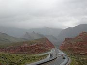
, and short in length at 29.39 miles (47.3 km), it remains notable for its scenic passage through the Virgin River Gorge
. The highway heads in a northeasterly direction from the Nevada
border northeast of Mesquite, Nevada
, to the Utah
border southwest of St. George, Utah
.
The south portion of I-15's route was built close to the alignment of the old U.S. Route 91 (US 91), but the northern section, through the Virgin River Gorge, was built along roadless terrain. The southern section of the highway was complete and open in the early 1960s, but the gorge section was inaccessible until 1973. When it opened, the Virgin River Gorge passage was the most expensive section of rural Interstate per mile.
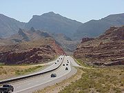
. Traffic volume along the Arizona section of I-15 is approximately 23,000 vehicles per day. The highway is also a part of the CANAMEX Corridor
, a trade corridor in North America linking Edmonton
, Alberta in Canada and Mexico City
.
 The highway enters the state in Mohave County northeast of Mesquite
and Las Vegas, Nevada
, paralleling the old US 91 heading northeast on an alignment north of the Virgin River
. I-15 parallels the Virgin River for its entire length in Arizona, but the terrain abruptly becomes more rugged at mile 13, where the Virgin River Gorge
begins. The first interchange is exit 8 at Littlefield
, where old US 91 turns north to avoid the gorge. I-15 crosses the river for the first time just beyond Littlefield, and soon passes another interchange serving local roads eastwards. This exit, exit 9, is a right-in/right-out
design with frontage road
s, constructed after the initial opening. Access under I-15 is provided just south of the ramps.
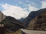
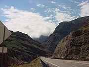
 Beyond exit 9, I-15 enters the Virgin River Gorge, first passing through "The Narrows". Here, the gorge features limestone
cliffs that are as high as 500 feet (152.4 m) above the highway. Several pulloffs allow access to these cliffs. Within the canyon, through which it ascends northbound and descends southbound, five bridges cross the river. The highway generally follows the winding course of the river, but several rock cuts bypass bends.
The canyon opens up slightly at the Cedar Pocket interchange (exit 18), allowing for a rest area
. This rest area was turned over to the federal Bureau of Land Management
in 2002 which maintains the nearby Virgin River Gorge Recreation Area. The rest area was demolished in 2009. I-15 continues to parallel the Virgin River, but begins to deviate more. Trees here include tamarix
, ash
, cottonwoods, willow
s and Joshua trees. Wildflowers such as globemallow
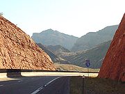
, marigold
, and sand verbena dot the route in springtime. At mile 22.5, the highway crosses the Virgin River for the final time, continuing east along the smaller Black Rock Gulch before then turning slightly northeast into a flatter area. The final interchange (exit 27) provides local access.
A weigh station
/port of entry
formerly served both sides of the road near mile 28 before the Utah state line. The weigh station/port of entry are now combined into a joint Arizona/Utah facility just north of the state line staffed by the Arizona Department of Transportation
(DOT) Motor Vehicle Division and Utah DOT Motor Carrier Division. I-15 continues on into Utah providing access to St. George
as well as Salt Lake City
.
 The Old Spanish Trail
from Southern California
had two routes through northwestern Arizona, splitting at Littlefield; one went north towards central Utah, and the other went northeast through the Virgin River Gorge, straddling the state line to the Four Corners area. When the Arrowhead Trail was marked in the 1920s, and U.S. Route 91 in 1926, automobile travelers between Nevada and Utah followed the northerly routing, turning east in Utah to reach St. George.
When the Interstates were planned, federal authorities decided to save 12 miles (19 km) over US 91 and pass through the Virgin River Gorge
to take advantage of its scenery and lower grades for trucks. Construction was completed first, in the early 1960s, on the portion between Nevada and the gorge. The bridges over Big Bend Wash were completed in 1962. The bridge over the Virgin River near Littlefield was completed by 1964. By 1965, the overpass over Black Rock Road (northwards) was finally complete.
 Construction through the gorge was slower and much more difficult, and the segment could not fully open until December 14, 1973. To help quicken construction, the state of Utah
loaned a portion of their federal highway funds to Arizona. Even though the highway is of little importance to the transportation needs of Arizona, as it does not link any Arizona communities, it does serve as a vital link between Salt Lake City
and Las Vegas
and Los Angeles
to the southwest. Despite extra funding, however, challenges remained. Flash flooding and quicksand in the gorge repeatedly caused problems, with equipment and materials apparently disappearing overnight. Worse, the project was to claim a life, when in October 1969, a helicopter performing reconnaissance on the gorge crashed due to wind, killing the pilot. To help navigate the gorge's rugged and unforgiving terrain, a special piece of equipment called a swamp buggy
had to be brought from Texas
. Even with this help, the route still demanded construction of four bridges over Virgin River. The westernmost bridge and the bridge carrying the northbound lanes at the third bridge location from the west were completed in 1972. By 1973, all five bridges were finally complete.
Even before its opening, it was promoted as the most scenic highway in the state; a 1988 article in Arizona Highways said that the project "enhanced rather than distracted from Nature's handiwork". The Virgin River was rechanneled 12 times in what was the most expensive rural freeway in the country, at the price of approximately $10 million per mile ($49 million in 2007 dollars).
San Diego, California
San Diego is the eighth-largest city in the United States and second-largest city in California. The city is located on the coast of the Pacific Ocean in Southern California, immediately adjacent to the Mexican border. The birthplace of California, San Diego is known for its mild year-round...
, United States, to the Canadian border, through Mohave County
Mohave County, Arizona
Mohave County is located in the northwestern corner of the U.S. state of Arizona. As of the 2010 census, its population was 200,186, an increase of 45,154 people since the 2000 census count of 155,032. The county seat is Kingman...
in northwest Arizona
Arizona
Arizona ; is a state located in the southwestern region of the United States. It is also part of the western United States and the mountain west. The capital and largest city is Phoenix...
. Despite being isolated from the rest of Arizona, in the remote Arizona Strip
Arizona Strip
The Arizona Strip is the part of the U.S. state of Arizona lying north of the Colorado River. The difficulty of crossing the Grand Canyon causes this region to have more natural connections with southern Utah and Nevada than with the rest of Arizona....
, and short in length at 29.39 miles (47.3 km), it remains notable for its scenic passage through the Virgin River Gorge
Virgin River Gorge
The Virgin River Gorge, located between St. George, Utah, and Littlefield, Arizona, is a long canyon that has been carved out by the Virgin River in northwest Arizona. The Virgin River rises on the Colorado Plateau and created the topography of both Zion National Park and the Virgin River Gorge...
. The highway heads in a northeasterly direction from the Nevada
Nevada
Nevada is a state in the western, mountain west, and southwestern regions of the United States. With an area of and a population of about 2.7 million, it is the 7th-largest and 35th-most populous state. Over two-thirds of Nevada's people live in the Las Vegas metropolitan area, which contains its...
border northeast of Mesquite, Nevada
Mesquite, Nevada
Mesquite is a city in Clark County, Nevada, United States, adjacent to the Arizona state line and northeast of Las Vegas. As of the 2010 United States Census, it had a population of 15,277. The city is located in the Virgin River Valley...
, to the Utah
Utah
Utah is a state in the Western United States. It was the 45th state to join the Union, on January 4, 1896. Approximately 80% of Utah's 2,763,885 people live along the Wasatch Front, centering on Salt Lake City. This leaves vast expanses of the state nearly uninhabited, making the population the...
border southwest of St. George, Utah
St. George, Utah
St. George is a city located in the southwestern part of the U.S. state of Utah, and the county seat of Washington County, Utah. It is the principal city of and is included in the St. George, Utah, Metropolitan Statistical Area. The city is 119 miles northeast of Las Vegas, Nevada, and 303 miles ...
.
The south portion of I-15's route was built close to the alignment of the old U.S. Route 91 (US 91), but the northern section, through the Virgin River Gorge, was built along roadless terrain. The southern section of the highway was complete and open in the early 1960s, but the gorge section was inaccessible until 1973. When it opened, the Virgin River Gorge passage was the most expensive section of rural Interstate per mile.
Route description
The highway is signed and designated the Veterans Memorial Highway, a designation which continues into UtahUtah
Utah is a state in the Western United States. It was the 45th state to join the Union, on January 4, 1896. Approximately 80% of Utah's 2,763,885 people live along the Wasatch Front, centering on Salt Lake City. This leaves vast expanses of the state nearly uninhabited, making the population the...
. Traffic volume along the Arizona section of I-15 is approximately 23,000 vehicles per day. The highway is also a part of the CANAMEX Corridor
CANAMEX Corridor
The CANAMEX corridor is a corridor linking Canada to Mexico through the United States. The corridor was established under the North American Free Trade Agreement.Currently the corridor is defined by a series of highways...
, a trade corridor in North America linking Edmonton
Edmonton
Edmonton is the capital of the Canadian province of Alberta and is the province's second-largest city. Edmonton is located on the North Saskatchewan River and is the centre of the Edmonton Capital Region, which is surrounded by the central region of the province.The city and its census...
, Alberta in Canada and Mexico City
Mexico City
Mexico City is the Federal District , capital of Mexico and seat of the federal powers of the Mexican Union. It is a federal entity within Mexico which is not part of any one of the 31 Mexican states but belongs to the federation as a whole...
.
Mesquite, Nevada
Mesquite is a city in Clark County, Nevada, United States, adjacent to the Arizona state line and northeast of Las Vegas. As of the 2010 United States Census, it had a population of 15,277. The city is located in the Virgin River Valley...
and Las Vegas, Nevada
Las Vegas, Nevada
Las Vegas is the most populous city in the U.S. state of Nevada and is also the county seat of Clark County, Nevada. Las Vegas is an internationally renowned major resort city for gambling, shopping, and fine dining. The city bills itself as The Entertainment Capital of the World, and is famous...
, paralleling the old US 91 heading northeast on an alignment north of the Virgin River
Virgin River
The Virgin River is a tributary of the Colorado River in the U.S. states of Utah, Nevada, and Arizona. The river is about long. It was designated Utah's first wild and scenic river in 2009, during the centennial celebration of Zion National Park.-Course:...
. I-15 parallels the Virgin River for its entire length in Arizona, but the terrain abruptly becomes more rugged at mile 13, where the Virgin River Gorge
Virgin River Gorge
The Virgin River Gorge, located between St. George, Utah, and Littlefield, Arizona, is a long canyon that has been carved out by the Virgin River in northwest Arizona. The Virgin River rises on the Colorado Plateau and created the topography of both Zion National Park and the Virgin River Gorge...
begins. The first interchange is exit 8 at Littlefield
Littlefield, Arizona
Littlefield is an unincorporated community in Mohave County located in the Arizona Strip region of the U.S. state of Arizona. It is located along Interstate 15 approximately 10 miles northeast of Mesquite, Nevada...
, where old US 91 turns north to avoid the gorge. I-15 crosses the river for the first time just beyond Littlefield, and soon passes another interchange serving local roads eastwards. This exit, exit 9, is a right-in/right-out
Right-in/right-out
Right-in/right-out and left-in/left-out refer to a type of road intersection where turning movements of vehicles are restricted. A RIRO permits only right turns and a LILO permits only left turns. RIRO is usual where vehicles drive on the right, and LILO is usual where vehicles drive on the left...
design with frontage road
Frontage road
A frontage road is a non-limited access road running parallel to a higher-speed road, usually a freeway, and feeding it at appropriate points of access...
s, constructed after the initial opening. Access under I-15 is provided just south of the ramps.
Limestone
Limestone is a sedimentary rock composed largely of the minerals calcite and aragonite, which are different crystal forms of calcium carbonate . Many limestones are composed from skeletal fragments of marine organisms such as coral or foraminifera....
cliffs that are as high as 500 feet (152.4 m) above the highway. Several pulloffs allow access to these cliffs. Within the canyon, through which it ascends northbound and descends southbound, five bridges cross the river. The highway generally follows the winding course of the river, but several rock cuts bypass bends.
The canyon opens up slightly at the Cedar Pocket interchange (exit 18), allowing for a rest area
Rest area
A rest area, travel plaza, rest stop, or service area is a public facility, located next to a large thoroughfare such as a highway, expressway, or freeway at which drivers and passengers can rest, eat, or refuel without exiting on to secondary roads...
. This rest area was turned over to the federal Bureau of Land Management
Bureau of Land Management
The Bureau of Land Management is an agency within the United States Department of the Interior which administers America's public lands, totaling approximately , or one-eighth of the landmass of the country. The BLM also manages of subsurface mineral estate underlying federal, state and private...
in 2002 which maintains the nearby Virgin River Gorge Recreation Area. The rest area was demolished in 2009. I-15 continues to parallel the Virgin River, but begins to deviate more. Trees here include tamarix
Tamarix
The genus Tamarix is composed of about 50-60 species of flowering plants in the family Tamaricaceae, native to drier areas of Eurasia and Africa...
, ash
Ash tree
Fraxinus is a genus flowering plants in the olive and lilac family, Oleaceae. It contains 45-65 species of usually medium to large trees, mostly deciduous though a few subtropical species are evergreen. The tree's common English name, ash, goes back to the Old English æsc, while the generic name...
, cottonwoods, willow
Willow
Willows, sallows, and osiers form the genus Salix, around 400 species of deciduous trees and shrubs, found primarily on moist soils in cold and temperate regions of the Northern Hemisphere...
s and Joshua trees. Wildflowers such as globemallow
Globemallow
Sphaeralcea is a genus of flowering plants in the mallow family . There are about 40-60 species, including annuals, perennials, and shrubs. Most originate in the drier regions of North America, with some known from South America. They are commonly known as globemallows, globe mallows, or falsemallows...
, marigold
Tagetes
Tagetes is a genus of 56 species of annual and perennial mostly herbaceous plants in the sunflower family . The genus is native to North and South America, but some species have become naturalized around the world. One species, T...
, and sand verbena dot the route in springtime. At mile 22.5, the highway crosses the Virgin River for the final time, continuing east along the smaller Black Rock Gulch before then turning slightly northeast into a flatter area. The final interchange (exit 27) provides local access.
A weigh station
Weigh station
A weigh station is a checkpoint along a highway to inspect vehicular weights. Usually, trucks and commercial vehicles are subject to the inspection....
/port of entry
Port of entry
In general, a port of entry is a place where one may lawfully enter a country. It typically has a staff of people who check passports and visas and inspect luggage to assure that contraband is not imported. International airports are usually ports of entry, as are road and rail crossings on a...
formerly served both sides of the road near mile 28 before the Utah state line. The weigh station/port of entry are now combined into a joint Arizona/Utah facility just north of the state line staffed by the Arizona Department of Transportation
Arizona Department of Transportation
The Arizona Department of Transportation is an Arizona state government agency charged with facilitating mobility within the state. In addition to managing the state's highway system, the agency is also involved with public transportation and municipal airports...
(DOT) Motor Vehicle Division and Utah DOT Motor Carrier Division. I-15 continues on into Utah providing access to St. George
St. George, Utah
St. George is a city located in the southwestern part of the U.S. state of Utah, and the county seat of Washington County, Utah. It is the principal city of and is included in the St. George, Utah, Metropolitan Statistical Area. The city is 119 miles northeast of Las Vegas, Nevada, and 303 miles ...
as well as Salt Lake City
Salt Lake City, Utah
Salt Lake City is the capital and the most populous city of the U.S. state of Utah. The name of the city is often shortened to Salt Lake or SLC. With a population of 186,440 as of the 2010 Census, the city lies in the Salt Lake City metropolitan area, which has a total population of 1,124,197...
.
History
Old Spanish Trail (trade route)
The Old Spanish Trail is a historical trade route which connected the northern New Mexico settlements near or in Santa Fe, New Mexico with that of Los Angeles, California and southern California. Approximately long, it ran through areas of high mountains, arid deserts, and deep canyons. It is...
from Southern California
Southern California
Southern California is a megaregion, or megapolitan area, in the southern area of the U.S. state of California. Large urban areas include Greater Los Angeles and Greater San Diego. The urban area stretches along the coast from Ventura through the Southland and Inland Empire to San Diego...
had two routes through northwestern Arizona, splitting at Littlefield; one went north towards central Utah, and the other went northeast through the Virgin River Gorge, straddling the state line to the Four Corners area. When the Arrowhead Trail was marked in the 1920s, and U.S. Route 91 in 1926, automobile travelers between Nevada and Utah followed the northerly routing, turning east in Utah to reach St. George.
When the Interstates were planned, federal authorities decided to save 12 miles (19 km) over US 91 and pass through the Virgin River Gorge
Virgin River Gorge
The Virgin River Gorge, located between St. George, Utah, and Littlefield, Arizona, is a long canyon that has been carved out by the Virgin River in northwest Arizona. The Virgin River rises on the Colorado Plateau and created the topography of both Zion National Park and the Virgin River Gorge...
to take advantage of its scenery and lower grades for trucks. Construction was completed first, in the early 1960s, on the portion between Nevada and the gorge. The bridges over Big Bend Wash were completed in 1962. The bridge over the Virgin River near Littlefield was completed by 1964. By 1965, the overpass over Black Rock Road (northwards) was finally complete.
Utah
Utah is a state in the Western United States. It was the 45th state to join the Union, on January 4, 1896. Approximately 80% of Utah's 2,763,885 people live along the Wasatch Front, centering on Salt Lake City. This leaves vast expanses of the state nearly uninhabited, making the population the...
loaned a portion of their federal highway funds to Arizona. Even though the highway is of little importance to the transportation needs of Arizona, as it does not link any Arizona communities, it does serve as a vital link between Salt Lake City
Salt Lake City, Utah
Salt Lake City is the capital and the most populous city of the U.S. state of Utah. The name of the city is often shortened to Salt Lake or SLC. With a population of 186,440 as of the 2010 Census, the city lies in the Salt Lake City metropolitan area, which has a total population of 1,124,197...
and Las Vegas
Las Vegas, Nevada
Las Vegas is the most populous city in the U.S. state of Nevada and is also the county seat of Clark County, Nevada. Las Vegas is an internationally renowned major resort city for gambling, shopping, and fine dining. The city bills itself as The Entertainment Capital of the World, and is famous...
and Los Angeles
Los Angeles, California
Los Angeles , with a population at the 2010 United States Census of 3,792,621, is the most populous city in California, USA and the second most populous in the United States, after New York City. It has an area of , and is located in Southern California...
to the southwest. Despite extra funding, however, challenges remained. Flash flooding and quicksand in the gorge repeatedly caused problems, with equipment and materials apparently disappearing overnight. Worse, the project was to claim a life, when in October 1969, a helicopter performing reconnaissance on the gorge crashed due to wind, killing the pilot. To help navigate the gorge's rugged and unforgiving terrain, a special piece of equipment called a swamp buggy
Swamp buggy
The Swamp Buggy is a vehicle used to traverse the vast, boggy swamps of the American South. Invented by Ed Frank[1], in Naples, Florida, the swamp buggy proved valuable during early development of the Everglades in the 1930s and 1940s....
had to be brought from Texas
Texas
Texas is the second largest U.S. state by both area and population, and the largest state by area in the contiguous United States.The name, based on the Caddo word "Tejas" meaning "friends" or "allies", was applied by the Spanish to the Caddo themselves and to the region of their settlement in...
. Even with this help, the route still demanded construction of four bridges over Virgin River. The westernmost bridge and the bridge carrying the northbound lanes at the third bridge location from the west were completed in 1972. By 1973, all five bridges were finally complete.
Even before its opening, it was promoted as the most scenic highway in the state; a 1988 article in Arizona Highways said that the project "enhanced rather than distracted from Nature's handiwork". The Virgin River was rechanneled 12 times in what was the most expensive rural freeway in the country, at the price of approximately $10 million per mile ($49 million in 2007 dollars).