
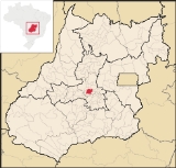
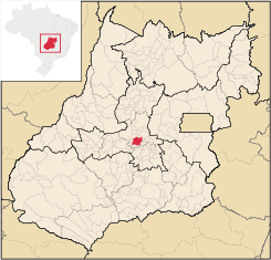
Inhumas
Encyclopedia
| Inhumas | |
|---|---|
| State | Goiás Goiás Goiás is a state of Brazil, located in the central part of the country. The name Goiás comes from the name of an indigenous community... |
| Area: | 613.3 km² |
| Population: | 44,983 (IBGE 2007) |
| Elevation: | 770m above sea level |
| Postcode (CEP): | 75400-000 |
| IBGE statistical microregion: | Anápolis Microregion Anápolis Microregion The Anápolis Microregion is a region of central Goiás state, Brazil, including municipalities surrounding the city of Anápolis. For a map see *Population: 517,221 inhabitants *Cities: 19*Total Area: 8,386.80 km²... |
| Became a city: | 1931 |
| Distance to Goiânia Goiânia -Climate:The city has a tropical wet and dry climate with an average temperature of . There's a wet season, from October to April, and a dry one, from May to September. Annual rainfall is around 1,520 mm.... : |
54 km. |
| Website: | Site da prefeitura municipal de Inhumas Site da cidade de Inhumas Lista Telefonica da cidade de Inhumas |
| Coordinates: | 16°21′18"S 49°29′35"W |
City
A city is a relatively large and permanent settlement. Although there is no agreement on how a city is distinguished from a town within general English language meanings, many cities have a particular administrative, legal, or historical status based on local law.For example, in the U.S...
and municipality
Municipality
A municipality is essentially an urban administrative division having corporate status and usually powers of self-government. It can also be used to mean the governing body of a municipality. A municipality is a general-purpose administrative subdivision, as opposed to a special-purpose district...
in central Goiás
Goiás
Goiás is a state of Brazil, located in the central part of the country. The name Goiás comes from the name of an indigenous community...
state, Brazil
Brazil
Brazil , officially the Federative Republic of Brazil , is the largest country in South America. It is the world's fifth largest country, both by geographical area and by population with over 192 million people...
. The population was 47,361 (2005 estimate) in a total area of 613.3 km² (10/10/2002). Inhumas is a large producer of sugarcane, poultry, milk, and meat.
Distances and Location
- Distance to the state capital: 54 km.
- Distance to regional center (AnápolisAnápolisAnápolis is the third largest city in the State of Goiás in Brazil. It lies in the center of a rich agricultural region and has become a leader in food processing and pharmaceutical plants.-Location and population:...
): 73 km. - Highway connections: state highway GO-070 north from GoiâniaGoiânia-Climate:The city has a tropical wet and dry climate with an average temperature of . There's a wet season, from October to April, and a dry one, from May to September. Annual rainfall is around 1,520 mm....
, through GoianiraGoianiraGoianira is a small city and municipality in central Goiás state, Brazil, located 32 kilometers northwest of the state capital, Goiânia. The population was 24,110 in a total area of 200.4 km² . Goianira is becoming a major producer of shoes.Goianira is four kilometers east of highway BR-457 /...
and then 22 km. north.
Inhumas is on the Meia Ponte River
Meia Ponte River
The Meia Ponte River is one of the most important rivers in the state of Goiás, Brazil. Its source lies 60 km north of the city of Goiânia and it flows through that city in a southern direction joining the Paranaíba river just downriver of Cachoeira Dourada Dam. The Paranaíba River marks the...
. Neighboring municipalities are Itauçu
Itauçu
Itauçu is a small town and municipality in central Goiás state, Brazil.-Location:Itauçu is located 64 km. northwest of the state capital, Goiânia and is part of the Anápolis Microregion...
, Petrolina
Petrolina
Petrolina is a city located in the southernmost point of the state of Pernambuco, in Brazil. The population was 281.851 in 2009 in a total area of 4756.8 km²....
, Damolândia
Damolândia
Damolândia is a small town and municipality in central Goiás state, Brazil.-Highway connections:The distance to Goiânia is 79 km. while the distance to Anápolis is 62 km. Highway connections from Goiânia: GO-462 / Santo Antônio de Goiás / GO-222 / Nova Veneza / GO-416...
, Brazabrantes
Brazabrantes
Brazabrantes is a small town and municipality in central Goiás state, Brazil.-Location:Brazabrantes is located 59 kilometers north of the important city of . Highway connections from the state capital of Goiânia are made by taking state highway GO-70 north to Goanira and then east to...
, Caturaí
Caturaí
Caturaí is a small town and municipality in central Goiás state, Brazil.Caturaí is 32 kilometers north of Goiânia and belongs to the Anápolis Microregion. It is connected to the state capital by highway GO-070...
, and Araçu
Araçu
Araçu is a small town and municipality in central Goiás state, Brazil.-Location:Araçu is part of the Anápolis Microregion and is a short distance northwest of the state capital, Goiânia. It has boundaries with Itaberaí, Itauçu, and Caturaí...
.
Demographics
- Population growth rate 1996/2006: 1.05.%
- Population in 2007: 44,983
- Population in 1980: 31,430
- Urban population in 2007: 42,421
- Rural population in 2007: 2,562
The economy
Main agricultural activities were cattle raising (72,800 head in 2005) and agriculture. Because of the fertility of the soil and abundance of water Inhumas has a large and varied agricultural production. The main crops are sugarcane (373,000 tons), coffee, rice, soybeans, citrus fruits and bananas.- Number of industrial establishments: 132
- Number of retail establishments: 486
- Banking establishments: Banco do Brasil S.A.,BRADESCO S.A., Banco Itaú S.A., CEF, HSBC Bank Brasil S.A., Banco Multiplo (August 2007)
- Dairies: Laticínios Guerreiro Ltda. (22/05/2006)
- Industrial parks: Distrito Agroindustrial de Inhumas - DAI (June/2006)
- Distilleries: Centroálcool S/A - CENASA. (July/2007)
- Meat-packing plants: Frigorífico Vale da Goiabeira Ltda., Hiperboi Indústria e Comércio Ltda. (22/05/2006)
Agricultural data 2006
- Farms: 678
- Total area: 38,854 ha.
- Area of permanent crops: 1,377 ha.
- Area of perennial crops: 5,611 ha.
- Area of natural pasture: 25,142 ha.
- Area of woodland and forests: 5,688 ha.
- Persons dependent on farming: 2,100
- Farms with tractors: 56
- Number of tractors: 121
- Cattle herd: 72,800 head IBGE
Education and health
The literacy rate was 87.8% and the infant mortality rate was 20.7 in 1,000 live births. There were 49 schools in the municipality and 5 small hospitals. There is a campus of the State University of Goiás (UEG) offering courses in zoo technology and nursing.Municipal Human Development Index
Human Development Index
The Human Development Index is a composite statistic used to rank countries by level of "human development" and separate "very high human development", "high human development", "medium human development", and "low human development" countries...
- MHDI: 0.765
- State ranking: 46 (out of 242 municipalities)
- National ranking: 1,454 (out of 5,507 municipalities)
History
Inhumas was important as a stopping point on the Estrada Real linking the south with Goiás VelhoGoiás, Goiás
Goiás is a small city and municipality in the state of Goiás in Brazil. The population was 24,072 in a total area of 3,108 km² . It is the former capital of the state and preserves much of its colonial heritage...
. The first settlement was called Goiabeiras, because of the extensive groves of guava trees. It had fertile soil and attracted many immigrants, especially Syrians and Lebanese (Asmar, Sahium, Raiza, Chalub, Mahmud, Gebrim, Charter, Sebba, Nacruht), Italians (Pessoni, Qualhato, Serravali, Balestra, Quintanilha, Jácomo) and Japanese (Watanabe, Momonuke). The Syrian-Lebanese were the first to open commercial establishments in the 1930s. The Italians cultivated coffee and the Japanese worked on small farms producing garden vegetables. At one time the region was a major producer of coffee.
In 1896 Goiabeiras was elevated to the status of district in the municipality of Itaberaí
Itaberaí
Itaberaí is a small city and municipality in central Goiás state, Brazil. Itaberaí is a large producer of agricultural products including corn, rice, soybeans, tomatoes, and sugarcane.-Location:...
. In 1908 the name was changed to "Inhumas" in homage to a local bird also known as inhuma or anhuma (Anhima cornuta
Horned Screamer
The Horned Screamer is a member of a small family of birds, the Anhimidae, which occurs in wetlands of tropical South America...
)
In 1931 Inhumas was dismembered from Itaberaí to become a municipality. For the history see Tudoinhumas and Inhumas.go