
Itaberaí
Encyclopedia
| Itaberaí | |
|---|---|
| State | Goiás Goiás Goiás is a state of Brazil, located in the central part of the country. The name Goiás comes from the name of an indigenous community... |
| Coordinates: | 16°00′30"S 49°47′46"W |
| Area: | 1,471.1 km² |
| Population: | 30,609 (IBGE 2007 estimate) |
| Population Density: | 20.81 hab/km² (2007) |
| Elevation: | 701 m above sea level |
| Postcode (CEP): | 76630-000 |
| Became a city: | 1868 |
| Distance to Goiânia Goiânia -Climate:The city has a tropical wet and dry climate with an average temperature of . There's a wet season, from October to April, and a dry one, from May to September. Annual rainfall is around 1,520 mm.... : |
111 km. |
| IBGE statistical microregion: | Anápolis Microregion Anápolis Microregion The Anápolis Microregion is a region of central Goiás state, Brazil, including municipalities surrounding the city of Anápolis. For a map see *Population: 517,221 inhabitants *Cities: 19*Total Area: 8,386.80 km²... |
| Website: | Itaberaí Net |
City
A city is a relatively large and permanent settlement. Although there is no agreement on how a city is distinguished from a town within general English language meanings, many cities have a particular administrative, legal, or historical status based on local law.For example, in the U.S...
and municipality
Municipality
A municipality is essentially an urban administrative division having corporate status and usually powers of self-government. It can also be used to mean the governing body of a municipality. A municipality is a general-purpose administrative subdivision, as opposed to a special-purpose district...
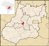
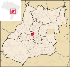
in central Goiás state, Brazil
Brazil
Brazil , officially the Federative Republic of Brazil , is the largest country in South America. It is the world's fifth largest country, both by geographical area and by population with over 192 million people...
. Itaberaí is a large producer of agricultural products including corn, rice, soybeans, tomatoes, and sugarcane.
Location
Itaberaí is located 92 kilometers north-west of GoiâniaGoiânia
-Climate:The city has a tropical wet and dry climate with an average temperature of . There's a wet season, from October to April, and a dry one, from May to September. Annual rainfall is around 1,520 mm....
on state highway GO-070 and 36 kilometers southeast of the former capital, Cidade de Goiás
Goiás, Goiás
Goiás is a small city and municipality in the state of Goiás in Brazil. The population was 24,072 in a total area of 3,108 km² . It is the former capital of the state and preserves much of its colonial heritage...
. Itaberaí is part of the Anápolis Microregion
Anápolis Microregion
The Anápolis Microregion is a region of central Goiás state, Brazil, including municipalities surrounding the city of Anápolis. For a map see *Population: 517,221 inhabitants *Cities: 19*Total Area: 8,386.80 km²...
.
- Neighboring municipalities: Americano do BrasilAmericano do BrasilAmericano do Brasil is a small town and municipality in eastern Goiás state, Brazil.-Location:Americano do Brasil is located in the Anicuns Microregion, which is northwest of the state capital, Goiânia. It is 37 kilometers southwest of Itaberaí and 113 kilometers northwest of Goiânia. Highway...
, AnicunsAnicunsAnicuns is a small city and municipality in central Goiás state, Brazil.-Geographical Facts:Anicuns is located in the Anicuns Microregion, which includes 13 cities with a population of 103276 inhabitants in a total area of 5483.10 km²....
, AraçuAraçuAraçu is a small town and municipality in central Goiás state, Brazil.-Location:Araçu is part of the Anápolis Microregion and is a short distance northwest of the state capital, Goiânia. It has boundaries with Itaberaí, Itauçu, and Caturaí...
, AvelinópolisAvelinópolisAvelinópolis is a small town and municipality in eastern Goiás state, Brazil.-Communications and Location:The distance to the regional center of is 26 km. Highway connections from the state capital are made by state highway BR-069 west from Goiânia, through Trindade, Santa Bárbara de Goiás,...
, Cidade de GoiásGoiás, GoiásGoiás is a small city and municipality in the state of Goiás in Brazil. The population was 24,072 in a total area of 3,108 km² . It is the former capital of the state and preserves much of its colonial heritage...
, HeitoraíHeitoraíHeitoraí is a small town and municipality in central Goiás state, Brazil.-Location:Heitoraí lies 142 km. from the regional center of Anápolis...
, ItaguariItaguariItaguari is a small town and municipality in central Goiás state, Brazil.-Location and Connections:The distance to the state capital is 109 km., while the distance to the regional center is 116 km....
, ItaguaruItaguaruItaguaru is a small town and municipality in central Goiás state, Brazil.-Location:The distance to the regional center of is 127 km....
, ItauçuItauçuItauçu is a small town and municipality in central Goiás state, Brazil.-Location:Itauçu is located 64 km. northwest of the state capital, Goiânia and is part of the Anápolis Microregion...
, MossâmedesMossâmedesMossâmedes is a small town and municipality in western Goiás state, Brazil.-Location:Mossâmedes is located northwest of the state capital, Goiânia in the Anicuns Microregion. It is connected by paved roads with Itaberaí to the north and Anicuns to the south. The distance to the state capital is...
, Taquaral de GoiásTaquaral de GoiásTaquaral de Goiás is a small town and municipality in central Goiás state, Brazil.-Location:Taquaral is located approximately 100 km. northwest of regional center, Anápolis. It is 22 km. west of Santa Rosa de Goiás and 25 km. east of Itaberaí...
and UruanaUruanaUruana is a small city and municipality in central Goiás state, Brazil. It is known statewide as the watermelon capital of the state.-Location:...
.
- Districts (distritos), villages (povoados), and hamlets (aglomerados): - Povoados: Congomé, Santa Rita and Santo Antônio. - Aglomerados: Lobeira, São Benedito and São José do Retiro.
Climate
The climate is humid tropical with regular rains in the summer. The most important rivers are Rio das Pedras, Rio Uru, which has its source in the Serra Dourada and forms a boundary with the municipality of GoiásGoiás, Goiás
Goiás is a small city and municipality in the state of Goiás in Brazil. The population was 24,072 in a total area of 3,108 km² . It is the former capital of the state and preserves much of its colonial heritage...
.
Demographic data
- Population growth rate 1991/2000: 1.29.%
- Population in 1980: 25,822 (Urban: 11,779; Rural: 14,043)
- Population in 1991: 24,852
- Urban population in 2003: 29,775
- Rural population in 2003: 6,858
The economy
Itaberaí is privileged to have fertile soil, ideal for the growing of sugarcane (4,912 hectares in 2006), corn (10,000 hectares in 2006) soybeans (9,000 hectares in 2006), rice and beans, besides the large number of dairy and beef cattle (125,000 head). The strongest part of the local economy is a chicken processing industry called Super Frango, which is one of the largest in the state. There is also a feed factory and a storage facility for soybeans and corn. See Sepin for complete data.Education (2006)
There were 24 schools in activity in 2005 with 354 teachers.- Higher education: UEG - Faculdade Estadual de Ciências Agrárias, Humanas e Letras de Itaberaí – Faculdade Est. Rio da Pedras
- Literacy Rate: 84.2%
Health (2007)
There were 3 hospitals with 121 beds, 6 walk-in clinics, 24 doctors, 4 nurses, and 5 dentists. The infant mortality rate was 25.11 (in 1,000 live births)Human Development Index
Human Development Index
The Human Development Index is a composite statistic used to rank countries by level of "human development" and separate "very high human development", "high human development", "medium human development", and "low human development" countries...
- MHDI: 0.739
- State ranking: 106 (out of 242 municipalities in 2000)
- National ranking: 2,161 (out of 5,507 municipalities in 2000)
All data are from 2000
For the complete list see frigoletto.com.br
History
The city has its origins in the seventeenth century when gold seekers arrived in the region. By 1855 there were 52 houses and two streets. With the name Curralinho it became a vila in 1868 and finally a municipality in 1924 with the name Itaberaí, which means River of Bright Rocks in Tupi-Guarani.Fundador: Salvador Pedroso de Campos
Sources of data
External links
See also
List of municipalities in Goiás