
Industrial Canal Lock
Encyclopedia
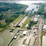
 Looking south toward the Lower Mississippi River |
|
| Length: | |
|---|---|
| Width: | |
| Type: | |
| Maximum lift: | |
| Sill: | |
| Waterway(s): | |
| Year built: | |
| Geolocation: | 29.965°N 90.02735°W |
The Inner Harbor Navigation Canal Lock—commonly known as Industrial Canal Lock or simply Industrial Lock—is a navigation lock in New Orleans. It connects the Lower Mississippi River
Lower Mississippi River
The Lower Mississippi River is the portion of the Mississippi River downstream of Cairo, Illinois. From the confluence of the Ohio River and Upper Mississippi River at Cairo, the Lower flows just under 1600 kilometers to the Gulf of Mexico...
to the Industrial Canal
Industrial Canal
The Industrial Canal is a 5.5 mile waterway in New Orleans, Louisiana, United States. The waterway's proper name, as used by the U.S. Army Corps of Engineers and on NOAA nautical charts, is Inner Harbor Navigation Canal...
and other sea-level waterways. Because it is shorter and narrower than most modern locks on the Mississippi River System
Mississippi River System
The Mississippi River System, also referred to as the Western Rivers, is a mostly riverine network which includes the Mississippi River and connecting waterways....
, the 1920s vintage lock has become a bottleneck between the nation's two highest-tonnage waterways
Inland waterways of the United States
The inland waterways of the United States include over 25,000 miles of navigable waters. Much of the commercially important waterways of the United States consist of the Mississippi River System—the Mississippi River and connecting waterways.Almost all of the navigable rivers and canals in...
—the Mississippi and the Gulf Intracoastal Waterway
Gulf Intracoastal Waterway
The Gulf Intracoastal Waterway is the portion of the Intracoastal Waterway located along the Gulf Coast of the United States. It is a navigable inland waterway running approximately 1700 kilometers from Carrabelle, Florida, to Brownsville, Texas.The waterway provides a channel with a controlling...
.
The lock is located at Lower Mississippi River mile
River mile
In the United States, a River mile is a measure of distance in miles along a river from its mouth. River mile numbers begin at zero and increase further upstream. The corresponding metric unit using kilometers is the River kilometer...
92.6 AHP. Owing to the confluence
Confluence (geography)
In geography, a confluence is the meeting of two or more bodies of water. It usually refers to the point where two streams flow together, merging into a single stream...
of multiple waterways at the Industrial Canal and Lock, the lock chamber is also considered mile 6 EHL (east of Harvey Lock) on the Intracoastal and mile 63 on the Mississippi River-Gulf Outlet Canal
Mississippi River-Gulf Outlet Canal
The Mississippi River – Gulf Outlet Canal is a channel constructed by the United States Army Corps of Engineers in the mid-20th century that provided a shorter route between the Gulf of Mexico and New Orleans' inner harbor Industrial Canal via the Intracoastal Waterway...
.
Although the depth over the sill is 9.6 meters (31.5 ft), most of the traffic through the lock consists of shallower-draft
Draft (hull)
The draft of a ship's hull is the vertical distance between the waterline and the bottom of the hull , with the thickness of the hull included; in the case of not being included the draft outline would be obtained...
barge tows transiting the Intracoastal.
History
The Industrial Canal and Lock were built by the Port of New OrleansPort of New Orleans
The Port of New Orleans is a port located in New Orleans, Louisiana. It is the 1st in the United States based on volume of cargo handled, second-largest in the state after the Port of South Louisiana, and 13th largest in the U.S. based on value of cargo...
to provide navigation between the Mississippi River and Lake Pontchartrain
Lake Pontchartrain
Lake Pontchartrain is a brackish estuary located in southeastern Louisiana. It is the second-largest inland saltwater body of water in the United States, after the Great Salt Lake in Utah, and the largest lake in Louisiana. As an estuary, Pontchartrain is not a true lake.It covers an area of with...
. The project was completed in 1923.
In the 1930s, the federal Gulf Intracoastal Waterway
Gulf Intracoastal Waterway
The Gulf Intracoastal Waterway is the portion of the Intracoastal Waterway located along the Gulf Coast of the United States. It is a navigable inland waterway running approximately 1700 kilometers from Carrabelle, Florida, to Brownsville, Texas.The waterway provides a channel with a controlling...
connected to the Industrial Canal via Lake Pontchartrain and used the lock to connect to the Mississippi River. Commercial traffic using the lock paid a local toll of 5 cents per gross ton. Beginning in 1944, the federal government leased the lock and the southern segment of the canal, eliminating the toll.
In 1965 another waterway, the Mississippi River-Gulf Outlet Canal
Mississippi River-Gulf Outlet Canal
The Mississippi River – Gulf Outlet Canal is a channel constructed by the United States Army Corps of Engineers in the mid-20th century that provided a shorter route between the Gulf of Mexico and New Orleans' inner harbor Industrial Canal via the Intracoastal Waterway...
(MRGO), was completed and began using Industrial Lock. The MRGO was a deep-draft channel affording ocean-going vessels a short-cut from the Port of New Orleans
Port of New Orleans
The Port of New Orleans is a port located in New Orleans, Louisiana. It is the 1st in the United States based on volume of cargo handled, second-largest in the state after the Port of South Louisiana, and 13th largest in the U.S. based on value of cargo...
to the Gulf of Mexico
Gulf of Mexico
The Gulf of Mexico is a partially landlocked ocean basin largely surrounded by the North American continent and the island of Cuba. It is bounded on the northeast, north and northwest by the Gulf Coast of the United States, on the southwest and south by Mexico, and on the southeast by Cuba. In...
. Thus three different waterways—the Industrial Canal, the Intracoastal and the MRGO—were now using the same lock to connect to the river.
In 1986 the federal government purchased the Industrial Lock from the Port of New Orleans.
Recent repairs
The lock underwent major repairs in 1998. It was closed for two months, forcing marine traffic to take an oft-used detour through Breton SoundBreton Sound
Breton Sound is a sound of the Gulf of Mexico and a part of the coastline of the U.S. state of Louisiana. It lies off the southeast coast of the state and is partially enclosed by the Breton Islands....
near the mouth of the Mississippi River.
The $6 million project included $2 million in emergency repairs. The chamber was dewatered for the first time in 20 years, and concrete was replaced in portions of the chamber itself and in four of the eight valves. The valve mechanisms had suffered rust and corrosion and were replaced with stainless steel hardware.
Six of the ten original gates, fabricated around 1920 and weighing 250 tons apiece, were removed for sandblasting and replacement of weak spots. New seals and pintles were installed.
According to the U.S. Army Corps of Engineers
United States Army Corps of Engineers
The United States Army Corps of Engineers is a federal agency and a major Army command made up of some 38,000 civilian and military personnel, making it the world's largest public engineering, design and construction management agency...
website the lock was closed on 08/11/2008 for 60 days for repairs.
Replacement
Replacement of the canal lock with a larger lock was authorized as early as 1956, provided that traffic levels justified it. By the late 20th century, barge tows were waiting an average of ten hours to lock through. Despite community opposition in the adjacent Lower 9th Ward and BywaterBywater, New Orleans
Bywater is a neighborhood of the city of New Orleans. A subdistrict of the Bywater District Area, its boundaries as defined by the City Planning Commission are: Florida Avenue to the north, the Industrial Canal to the east, the Mississippi River to the south and Franklin Avenue Street to the west...
neighborhoods, Congress approved a $573 million replacement project in 1998, and site acquisition and preparation began.
The new lock design features a larger chamber—35.5 meters (110 ft) wide, 366 meters (1200 ft) long and 9.6 meters (31.5 ft) deep. The lock is designed to be precast nearby and floated to site, immediately north of the existing lock.
Ancillary and collateral work includes replacement of the adjacent St. Claude Avenue Bridge
St. Claude Avenue Bridge
The St. Claude Avenue Bridge is a bascule bridge with four vehicular lanes over the Industrial Canal in New Orleans, Louisiana. This was originally a combination railroad and automobile bridge, with two pairs of railroad tracks in the center of the lift span and automobile lanes straddling it...
and nearby Florida Avenue Bridge
Florida Avenue Bridge
The Florida Avenue Bridge is a vertical lift bridge spanning the Industrial Canal in New Orleans, Louisiana. The bridge has one railroad track, two vehicle lanes and two sidewalks...
.
Opponents of the replacement project argue that, in addition to causing environmental problems and economic disruption, lock construction is economically unjustified. Deep-draft ship traffic through the existing lock, for instance, declined by 29 percent between 1983 and 1991; and the primary barge commodity, coal, is projected to continue declining due to a number of economic and political factors. Proponents of the lock replacement project point to the same figures to support their contention that the existing obsolete lock is choking off commerce. Maritime interests also argue that in light of the closure of the MRGO
Mississippi River-Gulf Outlet Canal
The Mississippi River – Gulf Outlet Canal is a channel constructed by the United States Army Corps of Engineers in the mid-20th century that provided a shorter route between the Gulf of Mexico and New Orleans' inner harbor Industrial Canal via the Intracoastal Waterway...
, and the loss of the deepwater access it provided to the Gulf of Mexico, modern oceangoing vessels are unable to access the inner harbor of the Industrial Canal
Industrial Canal
The Industrial Canal is a 5.5 mile waterway in New Orleans, Louisiana, United States. The waterway's proper name, as used by the U.S. Army Corps of Engineers and on NOAA nautical charts, is Inner Harbor Navigation Canal...
, permanently limiting the canal's utility as a site for shipyards and other industry requiring water access. A significant industrial exodus in the wake of the Katrina-induced closure of the MRGO has already transpired, with International Shipholding, Bollinger Shipyards and New Orleans Cold Storage departing. Without a new lock, the Port of New Orleans
Port of New Orleans
The Port of New Orleans is a port located in New Orleans, Louisiana. It is the 1st in the United States based on volume of cargo handled, second-largest in the state after the Port of South Louisiana, and 13th largest in the U.S. based on value of cargo...
' France Road Container Terminal and Jourdan Road Wharf would also remain closed, as they too relied on the deepwater access provided by the MRGO.