
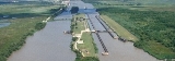
Gulf Intracoastal Waterway
Overview
Intracoastal Waterway
The Intracoastal Waterway is a 3,000-mile waterway along the Atlantic and Gulf coasts of the United States. Some lengths consist of natural inlets, salt-water rivers, bays, and sounds; others are artificial canals...
located along the Gulf Coast
Gulf Coast of the United States
The Gulf Coast of the United States, sometimes referred to as the Gulf South, South Coast, or 3rd Coast, comprises the coasts of American states that are on the Gulf of Mexico, which includes Texas, Louisiana, Mississippi, Alabama, and Florida and are known as the Gulf States...
of the United States. It is a navigable inland waterway
Inland waterways of the United States
The inland waterways of the United States include over 25,000 miles of navigable waters. Much of the commercially important waterways of the United States consist of the Mississippi River System—the Mississippi River and connecting waterways.Almost all of the navigable rivers and canals in...
running approximately 1700 kilometers (1050 mi) from Carrabelle
Carrabelle, Florida
Carrabelle is a city in Franklin County, Florida, United States. The population was 1,303 at the 2000 census. According to the U.S Census estimates of 2009, the city had a population of 1,231.-Location:...
, Florida
Florida
Florida is a state in the southeastern United States, located on the nation's Atlantic and Gulf coasts. It is bordered to the west by the Gulf of Mexico, to the north by Alabama and Georgia and to the east by the Atlantic Ocean. With a population of 18,801,310 as measured by the 2010 census, it...
, to Brownsville
Brownsville, Texas
Brownsville is a city in the southernmost tip of the state of Texas, in the United States. It is located on the northern bank of the Rio Grande, directly north and across the border from Matamoros, Tamaulipas, Mexico. Brownsville is the 16th largest city in the state of Texas with a population of...
, Texas
Texas
Texas is the second largest U.S. state by both area and population, and the largest state by area in the contiguous United States.The name, based on the Caddo word "Tejas" meaning "friends" or "allies", was applied by the Spanish to the Caddo themselves and to the region of their settlement in...
.
The waterway provides a channel with a controlling depth of 3.7 meters (12 ft), designed primarily for barge
Barge
A barge is a flat-bottomed boat, built mainly for river and canal transport of heavy goods. Some barges are not self-propelled and need to be towed by tugboats or pushed by towboats...
transportation. Although the U.S. government proposals for such a waterway were made in the early 19th century, the Gulf Intracoastal Waterway was not completed until 1949.
Locations along the Gulf Intracoastal Waterway are defined in terms of statute miles (as opposed to nautical miles, in which most marine routes are measured) east and west of Harvey Lock, a navigation lock in the New Orleans area located at 29.909°N 90.084°W.
Unanswered Questions