

Mississippi River-Gulf Outlet Canal
Encyclopedia
United States Army Corps of Engineers
The United States Army Corps of Engineers is a federal agency and a major Army command made up of some 38,000 civilian and military personnel, making it the world's largest public engineering, design and construction management agency...
in the mid-20th century that provided a shorter route between the Gulf of Mexico
Gulf of Mexico
The Gulf of Mexico is a partially landlocked ocean basin largely surrounded by the North American continent and the island of Cuba. It is bounded on the northeast, north and northwest by the Gulf Coast of the United States, on the southwest and south by Mexico, and on the southeast by Cuba. In...
and New Orleans
New Orleans, Louisiana
New Orleans is a major United States port and the largest city and metropolitan area in the state of Louisiana. The New Orleans metropolitan area has a population of 1,235,650 as of 2009, the 46th largest in the USA. The New Orleans – Metairie – Bogalusa combined statistical area has a population...
' inner harbor Industrial Canal
Industrial Canal
The Industrial Canal is a 5.5 mile waterway in New Orleans, Louisiana, United States. The waterway's proper name, as used by the U.S. Army Corps of Engineers and on NOAA nautical charts, is Inner Harbor Navigation Canal...
via the Intracoastal Waterway
Intracoastal Waterway
The Intracoastal Waterway is a 3,000-mile waterway along the Atlantic and Gulf coasts of the United States. Some lengths consist of natural inlets, salt-water rivers, bays, and sounds; others are artificial canals...
. In 2005, the MR-GO channelled Hurricane Katrina
Hurricane Katrina
Hurricane Katrina of the 2005 Atlantic hurricane season was a powerful Atlantic hurricane. It is the costliest natural disaster, as well as one of the five deadliest hurricanes, in the history of the United States. Among recorded Atlantic hurricanes, it was the sixth strongest overall...
's storm surge
Storm surge
A storm surge is an offshore rise of water associated with a low pressure weather system, typically tropical cyclones and strong extratropical cyclones. Storm surges are caused primarily by high winds pushing on the ocean's surface. The wind causes the water to pile up higher than the ordinary sea...
into the heart of Greater New Orleans, contributing significantly to the subsequent multiple engineering failures experienced by the region's hurricane protection network. In the aftermath the channel was closed. A permanent storm surge barrier is currently under construction in the MR-GO, and the channel has been closed to maritime shipping.
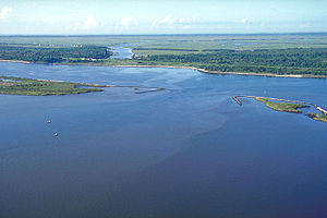
The MR-GO begins just east of I-510's
Interstate 510
Interstate 510 is a short spur route of Interstate 10 within in eastern New Orleans, Louisiana, United States. It runs south from Interstate 10, intersects with U.S. Highway 90, and ends at the Almonaster Boulevard interchange, near the NASA Michoud Assembly Facility...
crossing of the Gulf Intracoastal Waterway
Gulf Intracoastal Waterway
The Gulf Intracoastal Waterway is the portion of the Intracoastal Waterway located along the Gulf Coast of the United States. It is a navigable inland waterway running approximately 1700 kilometers from Carrabelle, Florida, to Brownsville, Texas.The waterway provides a channel with a controlling...
in New Orleans East
Eastern New Orleans
Eastern New Orleans is a large section of the city of New Orleans, Louisiana. Developed extensively from the 1960s onwards, it was originally marketed as "suburban-style living within the city limits", and has much in common with the Algiers neighborhood of New Orleans...
and takes a path SSE through St. Bernard Parish
St. Bernard Parish, Louisiana
St. Bernard Parish is a parish located southeast of New Orleans in the U.S. state of Louisiana. The parish seat is Chalmette, the largest city in the parish. As of 2000, its population was 67,229. It has been ranked the fastest-growing county in the United States from 2007 to 2008 by the U.S....
wetlands just west of Lake Borgne
Lake Borgne
Lake Borgne is a lagoon in eastern Louisiana of the Gulf of Mexico. Due to coastal erosion, it is no longer actually a lake but rather an arm of the Gulf of Mexico. Its name comes from the French word borgne, which means "one-eyed".-Geography:...
to the Gulf of Mexico near Gardner Island. Much criticized for its negative environmental effects, such as saltwater intrusion, wetlands erosion and storm surge amplification during Hurricane Katrina
Hurricane Katrina
Hurricane Katrina of the 2005 Atlantic hurricane season was a powerful Atlantic hurricane. It is the costliest natural disaster, as well as one of the five deadliest hurricanes, in the history of the United States. Among recorded Atlantic hurricanes, it was the sixth strongest overall...
, the MR-GO was closed in 2009. Maritime traffic was barred on April 22, 2009.
Conceptually, the MR-GO was first envisioned early in the 20th century as a way to provide shipping with a shorter route to the Gulf of Mexico. The Port of New Orleans
Port of New Orleans
The Port of New Orleans is a port located in New Orleans, Louisiana. It is the 1st in the United States based on volume of cargo handled, second-largest in the state after the Port of South Louisiana, and 13th largest in the U.S. based on value of cargo...
felt increasingly disadvantaged by the length of time oceangoing vessels needed to navigate the twists and turns of the Mississippi River
Mississippi River
The Mississippi River is the largest river system in North America. Flowing entirely in the United States, this river rises in western Minnesota and meanders slowly southwards for to the Mississippi River Delta at the Gulf of Mexico. With its many tributaries, the Mississippi's watershed drains...
from the Gulf to the port's wharfs, versus the much closer proximity to open water offered by its emerging competitors. The modern Port of Houston
Port of Houston
The Port of Houston is a port in Houston—the fourth-largest city in the United States. The Port is a 25-mile-long complex of diversified public and private facilities located a few hours' sailing time from the Gulf of Mexico...
, in particular, came into being as a consequence of the completion of the Houston Ship Channel
Houston Ship Channel
The Houston Ship Channel, located in Houston, Texas, is part of the Port of Houston—one of the United States's busiest seaports. The channel is the conduit for ocean-going vessels between the Houston-area shipyards and the Gulf of Mexico.-Overview:...
in 1914. New Orleans' initial response debuted in 1923, with the inauguration of the Industrial Canal
Industrial Canal
The Industrial Canal is a 5.5 mile waterway in New Orleans, Louisiana, United States. The waterway's proper name, as used by the U.S. Army Corps of Engineers and on NOAA nautical charts, is Inner Harbor Navigation Canal...
linking the Mississippi River and Lake Pontchartrain
Lake Pontchartrain
Lake Pontchartrain is a brackish estuary located in southeastern Louisiana. It is the second-largest inland saltwater body of water in the United States, after the Great Salt Lake in Utah, and the largest lake in Louisiana. As an estuary, Pontchartrain is not a true lake.It covers an area of with...
, thereby creating the Lower 9th Ward
Lower Ninth Ward
Lower Ninth Ward is a neighborhood of the city of New Orleans. As the name implies, it is part of the Ninth Ward of New Orleans. The Lower Ninth Ward is often thought of as the entire area within New Orleans downriver of the Industrial Canal; however, the City Planning Commission divides this...
and New Orleans East
Eastern New Orleans
Eastern New Orleans is a large section of the city of New Orleans, Louisiana. Developed extensively from the 1960s onwards, it was originally marketed as "suburban-style living within the city limits", and has much in common with the Algiers neighborhood of New Orleans...
. The rapid growth of average ship size in the 20th century rendered obsolete in a matter of decades the canal locks
Industrial Canal Lock
The Inner Harbor Navigation Canal Lock—commonly known as Industrial Canal Lock or simply Industrial Lock—is a navigation lock in New Orleans. It connects the Lower Mississippi River to the Industrial Canal and other sea-level waterways...
connecting the Industrial Canal to the Mississippi River; the MR-GO as promoted in the 1950s was to help rectify this deficiency by permitting deep-draft vessels to access the Industrial Canal inner harbor. Authorization for the MR-GO was formally provided by the Congress of the United States in the River and Harbor Act of 1956. Construction was completed in 1965.
Due to rapid erosion
Erosion
Erosion is when materials are removed from the surface and changed into something else. It only works by hydraulic actions and transport of solids in the natural environment, and leads to the deposition of these materials elsewhere...
of the surrounding marsh, the canal was already as much as three times wider by 1989 than as originally constructed. When MR-GO was built, the channel was 650 feet (198.1 m) wide at the surface. In 1989 the average width had become 1500 ft (457 m). This degradation continued for the next sixteen years.
MR-GO's operational performance
With the completion of MR-GO in 1965, the Port of New Orleans
Port of New Orleans
The Port of New Orleans is a port located in New Orleans, Louisiana. It is the 1st in the United States based on volume of cargo handled, second-largest in the state after the Port of South Louisiana, and 13th largest in the U.S. based on value of cargo...
advanced a plan to largely abandon its wharfs along the Mississippi River and relocate its activities to the inner harbor created by the Industrial Canal, the Intracoastal Waterway, and the MR-GO. This vast project, termed Centroport U.S.A., never secured sufficient funding and was quietly jettisoned by the port in the mid-1980s. The France Road Container Terminal and the Jourdan Road Wharf were the only two elements realized according to the Centroport plan.
After the abandonment of the Centroport project, the Port of New Orleans refocused its efforts on improving its infrastructure along the Mississippi River, and what little maritime traffic the MR-GO hosted progressively dwindled, opening it up to withering critiques.
In 1997, the Competitive Enterprise Institute, a libertarian
Libertarianism
Libertarianism, in the strictest sense, is the political philosophy that holds individual liberty as the basic moral principle of society. In the broadest sense, it is any political philosophy which approximates this view...
organization dedicated to "the principles of free enterprise and limited government" attacked it on economic grounds:
- The promised economic development along the 76 miles (122 km) channel in St. Bernard ParishSt. Bernard Parish, LouisianaSt. Bernard Parish is a parish located southeast of New Orleans in the U.S. state of Louisiana. The parish seat is Chalmette, the largest city in the parish. As of 2000, its population was 67,229. It has been ranked the fastest-growing county in the United States from 2007 to 2008 by the U.S....
has yet to materialize. What the MRGO has delivered is an $8-plus million yearly maintenance plan for commercial and recreational waterborne traffic. The nearly $1 billion price tag for the less than two large container ships a day that use the channel is baffling, especially considering that the channel only shaved 37 miles (60 km) off the original route. Worse, the MRGO has created numerous environmental problems. The rate of bank erosion is estimated at 15 feet (4.6 m) per year.
Prior to Hurricane Katrina
Hurricane Katrina
Hurricane Katrina of the 2005 Atlantic hurricane season was a powerful Atlantic hurricane. It is the costliest natural disaster, as well as one of the five deadliest hurricanes, in the history of the United States. Among recorded Atlantic hurricanes, it was the sixth strongest overall...
, environmentalists and others, including voters in St. Bernard Parish whom the canal was intended to help, called for its closure.
Criticism intensified following the hurricane, when engineers implicated the MR-GO in the failure of levee
Levee
A levee, levée, dike , embankment, floodbank or stopbank is an elongated naturally occurring ridge or artificially constructed fill or wall, which regulates water levels...
s and flood-walls protecting large parts of Greater New Orleans
New Orleans metropolitan area
New Orleans–Metairie–Kenner, or the Greater New Orleans Region is a metropolitan area designated by the United States Census encompassing seven parishes in the state of Louisiana, centering on the city of New Orleans...
. MR-GO was derisively termed a "Hurricane Highway" in Katrina's wake, due to its apparent role in amplifying the impacts of storm surges.
According to a congressional hearing statement made in late 2005 by Scott Faber of the Environmental Defense Fund, "Traffic on the MR-GO has fallen by more than 50 percent since 1986. Today, less than one oceangoing vessel per day, on average, uses this man-made short cut, which costs approximately $13 million annually to maintain. Like many waterways constructed by the Corps, the MR-GO has failed to attract as much traffic as the Corps predicted when the project was constructed."
Role in Hurricane Katrina disaster

St. Bernard Parish, Louisiana
St. Bernard Parish is a parish located southeast of New Orleans in the U.S. state of Louisiana. The parish seat is Chalmette, the largest city in the parish. As of 2000, its population was 67,229. It has been ranked the fastest-growing county in the United States from 2007 to 2008 by the U.S....
and New Orleans East
Eastern New Orleans
Eastern New Orleans is a large section of the city of New Orleans, Louisiana. Developed extensively from the 1960s onwards, it was originally marketed as "suburban-style living within the city limits", and has much in common with the Algiers neighborhood of New Orleans...
. Storm surge from the MR-GO is also a leading suspect in the three breaches of floodwalls along the Industrial Canal
Industrial Canal
The Industrial Canal is a 5.5 mile waterway in New Orleans, Louisiana, United States. The waterway's proper name, as used by the U.S. Army Corps of Engineers and on NOAA nautical charts, is Inner Harbor Navigation Canal...
.
Three months before Katrina, Hassan Mashriqui, a storm surge
Storm surge
A storm surge is an offshore rise of water associated with a low pressure weather system, typically tropical cyclones and strong extratropical cyclones. Storm surges are caused primarily by high winds pushing on the ocean's surface. The wind causes the water to pile up higher than the ordinary sea...
expert at Louisiana State University
Louisiana State University
Louisiana State University and Agricultural and Mechanical College, most often referred to as Louisiana State University, or LSU, is a public coeducational university located in Baton Rouge, Louisiana. The University was founded in 1853 in what is now known as Pineville, Louisiana, under the name...
's Hurricane Center, called MR-GO a "critical and fundamental flaw" in the Corps' hurricane defenses, a "Trojan Horse
Trojan Horse
The Trojan Horse is a tale from the Trojan War about the stratagem that allowed the Greeks finally to enter the city of Troy and end the conflict. In the canonical version, after a fruitless 10-year siege, the Greeks constructed a huge wooden horse, and hid a select force of men inside...
" that could amplify storm surges 20 to 40 percent. Following the storm, an engineering investigation and computer modeling showed that the outlet intensified the initial surge by 20 percent, raised the height of the wall of water about three feet, and increased the velocity of the surge from 3 foot per second (0.9144 m/s) to 8 feet per second (2.4 m/s) in the funnel-shaped region between the converging MR-GO and Gulf Intracoastal Waterway. Mashriqui believes this funnel effect contributed to the scouring that undermined the levees and floodwalls along the Gulf Outlet, the Intracoastal Waterway, and the Industrial Canal. "Without MRGO, the flooding would have been much less," he said. "The levees might have [been] overtopped, but they wouldn't have been washed away." The Army Corps of Engineers disputes this causality and maintains Katrina would have overwhelmed the levees with or without the contributing effect of MR-GO.
Katrina's passage caused extensive shoaling of the MR-GO, resulting in its impassability for deep-draft oceangoing vessels. Officials of St. Bernard Parish
St. Bernard Parish, Louisiana
St. Bernard Parish is a parish located southeast of New Orleans in the U.S. state of Louisiana. The parish seat is Chalmette, the largest city in the parish. As of 2000, its population was 67,229. It has been ranked the fastest-growing county in the United States from 2007 to 2008 by the U.S....
immediately opposed its reopening. Maritime interests called for re-opening the Gulf Outlet but equipping it with protective floodgates, or accelerating construction of the Inner Harbor Navigational Canal lock project
Industrial Canal
The Industrial Canal is a 5.5 mile waterway in New Orleans, Louisiana, United States. The waterway's proper name, as used by the U.S. Army Corps of Engineers and on NOAA nautical charts, is Inner Harbor Navigation Canal...
, which when completed would allow MR-GO to be closed without affecting deep-draft commercial traffic.
Closure
In May 2007 the U.S. Army Corps of Engineers announced it would close the MR-GO to all traffic and would build an earthen dam across the MR-GO in alignment with the natural ridge paralleling Bayou La Loutre. The Bayou La Loutre ridge siting was selected to complement future wetland restoration efforts, as the natural ridge could regain its historic function of sheltering the marsh and swamp behind from the Gulf of Mexico.Construction began in late 2008, and the Corps of Engineers completed the closure structure across the MR-GO at Bayou La Loutre in July 2009.
Surge Barrier
Closer to New Orleans, a robust 1.8 mile surge barrierFlood barrier
A flood barrier, surge barrier of storm surge barrier is a specific type of floodgate, designed to prevent a storm surge or spring tide from flooding the protected area behind the barrier...
costing more than $1 billion is under construction. The surge barrier will close the narrow end of the dangerous "funnel" described by the convergence of the levees bounding the northern edge of the Intracoastal Waterway
Gulf Intracoastal Waterway
The Gulf Intracoastal Waterway is the portion of the Intracoastal Waterway located along the Gulf Coast of the United States. It is a navigable inland waterway running approximately 1700 kilometers from Carrabelle, Florida, to Brownsville, Texas.The waterway provides a channel with a controlling...
and the southern edge of the MR-GO, preventing future storm surges from penetrating into the inner harbor of the Industrial Canal and Intracoastal Waterway. Two gates will be built, one at Bayou Bienvenue
Bayou Bienvenue
Bayou Bienvenue is a bayou in southeastern Louisiana. It runs along the political border between Orleans Parish and St. Bernard Parish to the east of New Orleans....
and another across the Intracoastal Waterway, to permit the passage of barge and other small commercial traffic during normal weather conditions. The barrier, the largest of its kind in the United States, should protect against storm surges up to 28 feet in height. It is to be fininshed by June 2011, and is far more significant than the Bayou La Loutre closure structure. When completed, it will be two feet lower than the levees it will connect to in New Orleans East and St. Bernard Parish. This will allow water to spill over the control structure before it overtops these levees.
See also
- ContainerizationContainerizationContainerization is a system of freight transport based on a range of steel intermodal containers...
- U.S. Army Corps of Engineers civil works controversies (New Orleans)#Legal issues in New Orleans
External links
- Army Corps liable for Katrina damage, US court finds Christian Science Monitor November 19, 2009
- Excerpt from The Control of Nature by John McPhee
- "Canal May Have Worsened City's Flooding", Washington Post, Wednesday, September 14, 2005
- U.S. Waterborne Container Traffic by Port/Waterway in 2003
- U.S. Seaports: At the Crossroads of the Global Economy
- Port of New Orleans