

Hurricane Roslyn (1986)
Encyclopedia
Hurricane Roslyn was the strongest hurricane in the 1986 Pacific hurricane season
. The 17th and final named storm of the season, Roslyn developed on October 15 to the south of Mexico
. Its movement was initially guided by a ridge
to its north, and it became a tropical storm on October 16 and a hurricane a day later. The hurricane reached peak winds of 145 mph (233.4 km/h) on October 19 before weakening and turning to the northeast. Roslyn ultimately moved ashore near Mazatlán
, Sinaloa
as a minimal hurricane, where it caused minimal damage due to the light population affected. It rapidly dissipated, although the remnants brought precipitation to Texas
and other portions of the central and southern United States
. There were no fatalities, and reported damage was minor.
 The final named storm of the season originated from a tropical disturbance that crossed Nicaragua
into the eastern Pacific Ocean
. With warm waters and increasing cyclonic
organization, it developed into Tropical Depression Twenty-Four on October 15 offshore Guatemala
. The system moved quickly west-northwestward under the influence of a ridge
over Mexico
. Quickly intensifying, the depression attained tropical storm status early on October 16; it was given the name Roslyn by the Eastern Pacific Hurricane Center
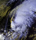
. An eye
became visible on satellite imagery, and by October 17 the storm reached hurricane status, while located about 400 miles (643.7 km) south of Acapulco
, Guerrero
.
As water temperatures remained very warm along its path, the hurricane was able to intensify quickly. Roslyn reached peak winds of 145 mph (230 km/h) 48 hours after attaining hurricane status, while located about 550 miles (885.1 km) southwest of Manzanillo, Colima
; that made it the strongest hurricane of the season. Roslyn maintained peak intensity for about 18 hours, during which it turned more to the northwest in response to a powerful advancing cold front
. On October 20, the hurricane curved northeastward as steady weakening ensued. After bypassing southeast of the Baja California Peninsula
, Hurricane Roslyn moved ashore on October 22 at Mazatlán
, Sinaloa
with winds of 75 mph (120 km/h). The low-level center rapidly dissipated, although the upper-level circulation continued northeastward along the advancing cold front. A frontal low developed in the western Gulf of Mexico
, which moved over southeastern Texas
and later through the Mississippi Valley. The original upper-level circulation maintained its northeast movement, bringing rainfall to the southeastern United States
.
, officials in Mazatlán
executed the evacuation of over 2,000 people in vulnerable coastal areas; such preparations prevented any deaths or injuries. Additionally, the owners of fishing vessels were advised to secure their properties by moving them to a safer area. As a result, only one yacht was sunk during the hurricane, and no major damage was reported by the fishing industry. Prior to moving ashore, Roslyn dropped light rainfall in extreme southern Baja California Sur
. On the mainland, precipitation extended to the southeast and northwest of where the hurricane moved ashore; the peak total was 13.11 inches (33.3 cm) to the southeast of Mazatlán. The brunt of the storm missed Mazatlán, instead affecting a sparsely-populated area. The highest reported winds from a land station were 44 mph (70.8 km/h), with gusts to 53 mph (85.3 km/h). Roslyn produced some flooding, but no serious damage. Impact was limited to flooded homes and factories, as well as some crop damage and beach erosion.
The remnants of Hurricane Roslyn produced heavy rainfall across the central and southern United States
. In Matagorda, Texas
, a total of 13.8 inches (35.05 cm) was reported, which was the highest rainfall total anywhere along Roslyn's path. The system dropped upwards of 5 inches (12.7 cm) in isolated locations of Alabama
, Arkansas
, Alabama
, Georgia
, and the Carolinas. The outskirts of the remnants of Roslyn brought rainfall to areas still recovering from significant flooding, partially caused by the earlier Hurricane Paine
. Clouds from Roslyn began affecting the southern United States a day before it made its original landfall. The storm prompted flash flood
watches in southeastern Texas, and the resulting rainfall flooded roadways and streams.
1986 Pacific hurricane season
The 1986 Pacific hurricane season was less active than the 1985 Pacific hurricane season. It officially started May 15, 1986 in the eastern Pacific, and June 1, 1986 in the central Pacific, and lasted until November 30, 1986. These dates conventionally delimit the period of each year when almost...
. The 17th and final named storm of the season, Roslyn developed on October 15 to the south of Mexico
Mexico
The United Mexican States , commonly known as Mexico , is a federal constitutional republic in North America. It is bordered on the north by the United States; on the south and west by the Pacific Ocean; on the southeast by Guatemala, Belize, and the Caribbean Sea; and on the east by the Gulf of...
. Its movement was initially guided by a ridge
Ridge (meteorology)
A ridge is an elongated region of relatively high atmospheric pressure, the opposite of a trough....
to its north, and it became a tropical storm on October 16 and a hurricane a day later. The hurricane reached peak winds of 145 mph (233.4 km/h) on October 19 before weakening and turning to the northeast. Roslyn ultimately moved ashore near Mazatlán
Mazatlán
Mazatlán is a city in the Mexican state of Sinaloa; the surrounding municipio for which the city serves as the municipal seat is Mazatlán Municipality. It is located at on the Pacific coast, across from the southernmost tip of the Baja California peninsula.Mazatlán is a Nahuatl word meaning...
, Sinaloa
Sinaloa
Sinaloa officially Estado Libre y Soberano de Sinaloa is one of the 31 states which, with the Federal District, comprise the 32 Federal Entities of Mexico. It is divided in 18 municipalities and its capital city is Culiacán Rosales....
as a minimal hurricane, where it caused minimal damage due to the light population affected. It rapidly dissipated, although the remnants brought precipitation to Texas
Texas
Texas is the second largest U.S. state by both area and population, and the largest state by area in the contiguous United States.The name, based on the Caddo word "Tejas" meaning "friends" or "allies", was applied by the Spanish to the Caddo themselves and to the region of their settlement in...
and other portions of the central and southern United States
United States
The United States of America is a federal constitutional republic comprising fifty states and a federal district...
. There were no fatalities, and reported damage was minor.
Meteorological history
Nicaragua
Nicaragua is the largest country in the Central American American isthmus, bordered by Honduras to the north and Costa Rica to the south. The country is situated between 11 and 14 degrees north of the Equator in the Northern Hemisphere, which places it entirely within the tropics. The Pacific Ocean...
into the eastern Pacific Ocean
Pacific Ocean
The Pacific Ocean is the largest of the Earth's oceanic divisions. It extends from the Arctic in the north to the Southern Ocean in the south, bounded by Asia and Australia in the west, and the Americas in the east.At 165.2 million square kilometres in area, this largest division of the World...
. With warm waters and increasing cyclonic
Cyclone
In meteorology, a cyclone is an area of closed, circular fluid motion rotating in the same direction as the Earth. This is usually characterized by inward spiraling winds that rotate anticlockwise in the Northern Hemisphere and clockwise in the Southern Hemisphere of the Earth. Most large-scale...
organization, it developed into Tropical Depression Twenty-Four on October 15 offshore Guatemala
Guatemala
Guatemala is a country in Central America bordered by Mexico to the north and west, the Pacific Ocean to the southwest, Belize to the northeast, the Caribbean to the east, and Honduras and El Salvador to the southeast...
. The system moved quickly west-northwestward under the influence of a ridge
Ridge (meteorology)
A ridge is an elongated region of relatively high atmospheric pressure, the opposite of a trough....
over Mexico
Mexico
The United Mexican States , commonly known as Mexico , is a federal constitutional republic in North America. It is bordered on the north by the United States; on the south and west by the Pacific Ocean; on the southeast by Guatemala, Belize, and the Caribbean Sea; and on the east by the Gulf of...
. Quickly intensifying, the depression attained tropical storm status early on October 16; it was given the name Roslyn by the Eastern Pacific Hurricane Center
Eastern Pacific Hurricane Center
The Eastern Pacific Hurricane Center was formerly the Regional Specialized Meteorological Center responsible for forecasting Pacific hurricanes in the eastern north Pacific east of 140°W...
. An eye
Eye (cyclone)
The eye is a region of mostly calm weather found at the center of strong tropical cyclones. The eye of a storm is a roughly circular area and typically 30–65 km in diameter. It is surrounded by the eyewall, a ring of towering thunderstorms where the second most severe weather of a cyclone...
became visible on satellite imagery, and by October 17 the storm reached hurricane status, while located about 400 miles (643.7 km) south of Acapulco
Acapulco
Acapulco is a city, municipality and major sea port in the state of Guerrero on the Pacific coast of Mexico, southwest from Mexico City. Acapulco is located on a deep, semi-circular bay and has been a port since the early colonial period of Mexico’s history...
, Guerrero
Guerrero
Guerrero officially Estado Libre y Soberano de Guerrero is one of the 31 states which, with the Federal District, comprise the 32 Federal Entities of Mexico. It is divided in 81 municipalities and its capital city is Chilpancingo....
.
As water temperatures remained very warm along its path, the hurricane was able to intensify quickly. Roslyn reached peak winds of 145 mph (230 km/h) 48 hours after attaining hurricane status, while located about 550 miles (885.1 km) southwest of Manzanillo, Colima
Manzanillo, Colima
The name Manzanillo refers to the city as well as its surrounding municipality in the Mexican state of Colima. The city, located on the Pacific Ocean, contains Mexico's busiest port. Manzanillo was the third port created by the Spanish in the Pacific during the New Spain period...
; that made it the strongest hurricane of the season. Roslyn maintained peak intensity for about 18 hours, during which it turned more to the northwest in response to a powerful advancing cold front
Trough (meteorology)
A trough is an elongated region of relatively low atmospheric pressure, often associated with fronts.Unlike fronts, there is not a universal symbol for a trough on a weather chart. The weather charts in some countries or regions mark troughs by a line. In the United States, a trough may be marked...
. On October 20, the hurricane curved northeastward as steady weakening ensued. After bypassing southeast of the Baja California Peninsula
Baja California Peninsula
The Baja California peninsula , is a peninsula in northwestern Mexico. Its land mass separates the Pacific Ocean from the Gulf of California. The Peninsula extends from Mexicali, Baja California in the north to Cabo San Lucas, Baja California Sur in the south.The total area of the Baja California...
, Hurricane Roslyn moved ashore on October 22 at Mazatlán
Mazatlán
Mazatlán is a city in the Mexican state of Sinaloa; the surrounding municipio for which the city serves as the municipal seat is Mazatlán Municipality. It is located at on the Pacific coast, across from the southernmost tip of the Baja California peninsula.Mazatlán is a Nahuatl word meaning...
, Sinaloa
Sinaloa
Sinaloa officially Estado Libre y Soberano de Sinaloa is one of the 31 states which, with the Federal District, comprise the 32 Federal Entities of Mexico. It is divided in 18 municipalities and its capital city is Culiacán Rosales....
with winds of 75 mph (120 km/h). The low-level center rapidly dissipated, although the upper-level circulation continued northeastward along the advancing cold front. A frontal low developed in the western Gulf of Mexico
Gulf of Mexico
The Gulf of Mexico is a partially landlocked ocean basin largely surrounded by the North American continent and the island of Cuba. It is bounded on the northeast, north and northwest by the Gulf Coast of the United States, on the southwest and south by Mexico, and on the southeast by Cuba. In...
, which moved over southeastern Texas
Texas
Texas is the second largest U.S. state by both area and population, and the largest state by area in the contiguous United States.The name, based on the Caddo word "Tejas" meaning "friends" or "allies", was applied by the Spanish to the Caddo themselves and to the region of their settlement in...
and later through the Mississippi Valley. The original upper-level circulation maintained its northeast movement, bringing rainfall to the southeastern United States
United States
The United States of America is a federal constitutional republic comprising fifty states and a federal district...
.
Preparations and impact
Prior to the hurricane's landfall in MexicoMexico
The United Mexican States , commonly known as Mexico , is a federal constitutional republic in North America. It is bordered on the north by the United States; on the south and west by the Pacific Ocean; on the southeast by Guatemala, Belize, and the Caribbean Sea; and on the east by the Gulf of...
, officials in Mazatlán
Mazatlán
Mazatlán is a city in the Mexican state of Sinaloa; the surrounding municipio for which the city serves as the municipal seat is Mazatlán Municipality. It is located at on the Pacific coast, across from the southernmost tip of the Baja California peninsula.Mazatlán is a Nahuatl word meaning...
executed the evacuation of over 2,000 people in vulnerable coastal areas; such preparations prevented any deaths or injuries. Additionally, the owners of fishing vessels were advised to secure their properties by moving them to a safer area. As a result, only one yacht was sunk during the hurricane, and no major damage was reported by the fishing industry. Prior to moving ashore, Roslyn dropped light rainfall in extreme southern Baja California Sur
Baja California Sur
Baja California Sur , is one of the 31 states which, with the Federal District, comprise the 32 Federal Entities of Mexico. Before becoming a state on October 8, 1974, the area was known as the South Territory of Baja California. It has an area of , or 3.57% of the land mass of Mexico and comprises...
. On the mainland, precipitation extended to the southeast and northwest of where the hurricane moved ashore; the peak total was 13.11 inches (33.3 cm) to the southeast of Mazatlán. The brunt of the storm missed Mazatlán, instead affecting a sparsely-populated area. The highest reported winds from a land station were 44 mph (70.8 km/h), with gusts to 53 mph (85.3 km/h). Roslyn produced some flooding, but no serious damage. Impact was limited to flooded homes and factories, as well as some crop damage and beach erosion.
The remnants of Hurricane Roslyn produced heavy rainfall across the central and southern United States
United States
The United States of America is a federal constitutional republic comprising fifty states and a federal district...
. In Matagorda, Texas
Matagorda, Texas
Matagorda is an unincorporated community in Matagorda County, Texas, United States. It had a population of approximately 710 in 2000. Matagorda is at the end of State Highway 60 and beginning of Farm to Market Road 2031, which runs over the Intracoastal Waterway and south to the Gulf of Mexico...
, a total of 13.8 inches (35.05 cm) was reported, which was the highest rainfall total anywhere along Roslyn's path. The system dropped upwards of 5 inches (12.7 cm) in isolated locations of Alabama
Alabama
Alabama is a state located in the southeastern region of the United States. It is bordered by Tennessee to the north, Georgia to the east, Florida and the Gulf of Mexico to the south, and Mississippi to the west. Alabama ranks 30th in total land area and ranks second in the size of its inland...
, Arkansas
Arkansas
Arkansas is a state located in the southern region of the United States. Its name is an Algonquian name of the Quapaw Indians. Arkansas shares borders with six states , and its eastern border is largely defined by the Mississippi River...
, Alabama
Alabama
Alabama is a state located in the southeastern region of the United States. It is bordered by Tennessee to the north, Georgia to the east, Florida and the Gulf of Mexico to the south, and Mississippi to the west. Alabama ranks 30th in total land area and ranks second in the size of its inland...
, Georgia
Georgia (U.S. state)
Georgia is a state located in the southeastern United States. It was established in 1732, the last of the original Thirteen Colonies. The state is named after King George II of Great Britain. Georgia was the fourth state to ratify the United States Constitution, on January 2, 1788...
, and the Carolinas. The outskirts of the remnants of Roslyn brought rainfall to areas still recovering from significant flooding, partially caused by the earlier Hurricane Paine
Hurricane Paine (1986)
Hurricane Paine in 1986 contributed to one of the most significant flooding events in Oklahoma history. The 16th tropical storm and 8th hurricane of the 1986 Pacific hurricane season, Paine formed on September 28 off the southeast coast of Mexico. It moved around a ridge, later turning to the north...
. Clouds from Roslyn began affecting the southern United States a day before it made its original landfall. The storm prompted flash flood
Flash flood
A flash flood is a rapid flooding of geomorphic low-lying areas—washes, rivers, dry lakes and basins. It may be caused by heavy rain associated with a storm, hurricane, or tropical storm or meltwater from ice or snow flowing over ice sheets or snowfields...
watches in southeastern Texas, and the resulting rainfall flooded roadways and streams.