
Hurricane Edith
Encyclopedia
Hurricane Edith was the strongest hurricane to form during the 1971 Atlantic hurricane season
. It developed from a tropical wave
on September 5 and quickly strengthened into a hurricane in the Caribbean Sea
. Edith rapidly intensified
on September 9 and made landfall on Cape Gracias a Dios as a Category 5 hurricane on the Saffir-Simpson Hurricane Scale
. It quickly lost intensity over Central America and after briefly entering the Gulf of Honduras
it crossed the Yucatán Peninsula
in Mexico. After moving across the Gulf of Mexico
a trough
turned the storm to the northeast and Edith, after having restrengthened while accelerating towards the coast, made landfall on Louisiana
with winds of 105 mph (170 km/h) on September 16. Edith steadily weakened over land and dissipated over Georgia
on September 18.
The hurricane killed two people when it passed near Aruba
. Striking northeastern Central America as a Category 5 hurricane, Edith destroyed hundreds of homes and killed at least 35 people. In Texas
high tides caused coastal flooding but little damage. Edith caused moderate to heavy damage in portions of Louisiana due to flooding and a tornado outbreak from the storm. One tornado, rated F3 on the Fujita Scale
, damaged several homes and injured multiple people in Baton Rouge
. The tornado outbreak extended eastward into Florida, of which a few destroyed entire buildings. Damage in the United States totaled $25 million (1971 USD
, $ USD).
moved off the coast of Africa near Dakar
on August 31. It moved westward into the Intertropical Convergence Zone
, and organized into a tropical disturbance on September 2 with a small, circular area of convection. The system moved to the west, and on September 3, the convection diminished after moving west of 40° W. By the next day, the tropical disturbance was barely discernible from the clouds of the Intertropical Convergence Zone. The wave gradually became detached from the ITCZ, and based on a reconnaissance flight
that confirmed the existence of a low-level circulation, it is estimated the system developed into a tropical depression on September 5 while located 255 miles (415 km) east of Grenada
.
The depression moved westward quickly, and moved through the southern Lesser Antilles
early on September 6. The southern portion of the circulation passed over northeastern Venezuela
, though after entering the Caribbean Sea
, another reconnaissance flight was unable to confirm the existence of a low-level circulation. Shortly thereafter, while moving into an area of light wind shear
, it was able to organize and strengthen further, and on September 7 the depression strengthened into Tropical Storm Edith
near the island of Curaçao
. While initially, a cold-core upper-level low
persisted about 750 miles (1200 km) northwest of the storm, Edith moved west-northwestward due to the influence of a narrow and persistent ridge of high pressure
, which extended from the southwestern Atlantic Ocean to the Gulf of Mexico
. As the storm continued into open waters of the Caribbean, the upper-level low gradually weakened and was replaced with an anticyclone
. This allowed the storm to strengthen further, and on September 8, Edith became a hurricane in the south-central Caribbean Sea.
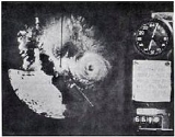
On September 9, the storm rapidly intensified
, and within 24 hours, Edith strengthened from a minimal hurricane to a powerful 160 mph (260 km/h) Category 5 hurricane just off the coast of Nicaragua
. The cause for the explosive deepening is unknown, though it is speculated that the transformation in the upper troposphere from an upper-level low to an anticyclone led to a release of baroclinic
energy. Reconnaissance aircraft crews in the peak of the storm reported extreme turbulence, causing concern for the safety of the crews. At its peak intensity, the very well-defined "pinhole" eye
was only 5 miles (8 km) in diameter. Late on September 9, Hurricane Edith made landfall on northeastern Nicaragua
at Cabo Gracias a Dios
.
 Hurricane Edith rapidly weakened over the mountainous terrain of northeastern Central America, and 18 hours after it made landfall, it emerged into the Gulf of Honduras
as an 80 mph (130 km/h) Category 1 hurricane
. It continued to weaken as it moved northwestward, and made landfall near Belize City
with tropical storm winds of 70 mph (115 km/h). Edith weakened further while crossing the Yucatán Peninsula
, and emerged into the Gulf of Mexico
near Campeche, Mexico
late on September 11 as a minimal tropical storm. Edith initially failed to re-intensify as it moved northwestward, despite low amounts of wind shear
and warm waters. This was because an anticyclone over the Gulf was closely connected with Hurricane Fern
, which developed and moved over the northwestern portion of the Gulf of Mexico. The anticyclone resulted in an easterly upper-level flow across Edith, creating conditions not conducive for intensification
. As Fern moved inland over Texas
, the flow became more favorable around Edith, and 36 hours after entering the Gulf of Mexico, the storm began to reintensify slightly.
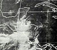
Edith continued moving to the west-northwest, heading towards the coast of Mexico, but early on September 14, the storm stalled while located just off the coast of Tamaulipas
. A mid-latitude trough of low pressure
approached the storm, and caused Edith to turn to slowly drift towards the northeast. Located only miles from the Mexican coast, Edith again failed to strengthen until September 15, when it accelerated northeastward and regained hurricane status. The hurricane turned to the east-northeast as it approached the coast of Louisiana
, and made landfall on September 16 in a sparsely populated area 30 miles (48 km) east of Cameron
with winds of 105 mph (170 km/h), equivalent to a Category 2 hurricane in the Saffir-Simpson Hurricane Scale
. Edith rapidly weakened over land, degenerating into a tropical storm over Louisiana, and into a tropical depression over Mississippi
. It continued to the east-northeast, and dissipated over northwestern Georgia
on September 18.
warned citizens about the extreme danger of the approaching hurricane, and asked them to prepare for hurricane conditions. While the storm was located in the Gulf of Mexico, the National Hurricane Center issued a Hurricane Warning from Cameron
to Morgan City, Louisiana
eighteen hours before the hurricane made landfall. Edith later struck land in the middle portion of the warning area.
In Belize
, officials ordered the mandatory evacuation of low-lying areas, resulting in hundreds of residents leaving to the United States through the international airport. Officials sent police troops to maintain order and prevent looting.
In the Gulf of Mexico
, several oil facilities were closed or placed on automatic controls. Drilling rig
s as far east as the coastal waters off of Mississippi
were prepared to evacuate in the event Edith moved further east than anticipated. Additionally, thousands evacuated coastal areas of Louisiana
prior to the arrival of the hurricane. Several shelters opened in coastal cities, and many people prepared for the hurricane
by purchasing emergency supplies. Officials closed schools throughout much of southern Louisiana.
 While passing through the southern Lesser Antilles
, the tropical depression produced heavy rainfall and winds of around 35 mph (55 km/h). Edith produced tropical storm force winds in Aruba
, and gusts reached 60 mph (95 km/h). Two fishermen were reported lost at sea and presumed dead as a result of Edith.
Edith produced strong winds across northeastern Nicaragua
and eastern Honduras
, with Puerto Lempira
reporting an unofficial sustained wind of 140 mph (225 km/h). Press reports indicated every house in the Cape Gracias area was destroyed or heavily damaged, leaving 7,000 homeless. The meteorological service in British Honduras
stated there were 100 fatalities near Cape Gracias, though a later report indicated 35 people died in Nicaragua. There, damage was estimated at over $380,000 (1971 USD
, $ USD). Three United States Air Force
aircraft delivered food, medical supplies, and fuel to the hurricane victims of Nicaragua. In Honduras, the hurricane produced 15 foot (4.5 m) tides and strong winds, while strong waves destroyed 40 fishing boats as well. While the hurricane reportedly destroyed entire villages, no deaths occurred in Honduras.
Offshore islands in Belize
reported winds of up to 60 mph (95 km/h). Edith produced flooding in a few towns in the southern portion of the country, with some buildings damaged. Heavy damage was reported near Monkey River Town
. Impact in Mexico, if any, is unknown.
 Two stations in Texas
recorded sustained tropical force winds, and Galveston
reported a peak wind gust of 53 mph (85 km/h). While moving past the state, Edith produced above normal tides of over 4 feet (1.2 m) in locations, which flooded a portion of Highway 87
. The storm dropped light to moderate amounts of rainfall peaking at 3.5 inches (89 mm) in Sabine Pass
. The passage of Hurricane Edith resulted in downed trees and power lines, and damage totaling $180,000 (1971 USD, $900,000 2006 USD).
Off the coast of Louisiana
, the hurricane wrecked three boats, but all the occupants were safely rescued. While making landfall in Louisiana
, Edith resulted in above normal tides of up to 9.7 feet (2.9 m) above normal at Cypremont Point near Morgan City
. The highest winds reported by a land station were 69 mph (111 km/h) at Cameron
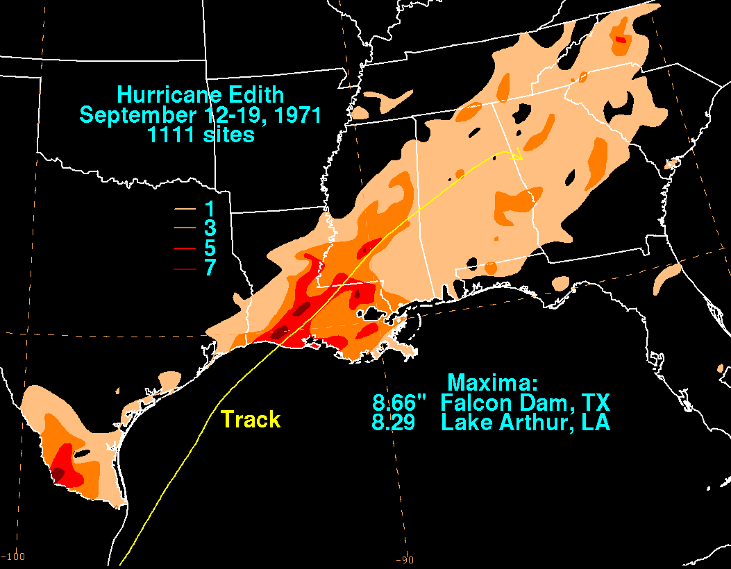
, where a wind gust of 96 mph (155 km/h) was also reported. However, due to the lack of recording instruments near the hurricane's landing point, whether higher winds occurred there is not known, although likely. Rainfall was moderate across Louisiana, including amounts of over 8 inches (200 mm) in the southwestern portion of the state. A strong rainband
well ahead of the hurricane, combined with the intrusion of dry air into the hurricane's circulation, produced 16 tornadoes from Louisiana to Alabama
. An F3 tornado
touched down in the eastern residential suburbs of Baton Rouge
, causing heavy property damage totaling $2.5 million (1971 USD
, $ USD) along its intermittent 7 mile (11 km) path. The tornado also injured three people. An F2 tornado in Tangipahoa Parish
caused $250,000 in damage (1971 USD
, $ USD) along its 4 mile (6 km) path, while an F1 tornado in St. Martin Parish
injured 6 people on its 3 mile (5 km) path. The hurricane caused extensive damage to the sugar cane crop in southwestern Louisiana. About a month after Edith struck the United States, President
Richard Nixon
declared portions of Louisiana
as a disaster area, which allocated relief funds to aid the affected citizens.
In Mississippi
, wind gusts peaked at 70 mph (112 km/h) in Hattiesburg
, with multiple locations reporting tropical-storm-force winds. Additionally, Edith produced moderate rainfall peaking at 6.15 inches (156 mm) in Liberty
. In Alabama
, the storm caused light rains, moderate wind gusts, and a storm tide of 2.7 feet (0.8 m) in Mobile
. Edith spawned four tornadoes in Alabama, three of which were F2
tornadoes. Two touched down in Baldwin County
; one destroyed two homes and damaged several others, and the other destroyed two mobile homes, a few barns, and damaged ten houses. Two tornadoes also touched down in Washington County
, one of which destroyed several small buildings and downed a few trees. In Florida, Edith produced slightly above-normal tides and light rain. It spawned a tornado in Pensacola, Florida
, injuring one person and inflicting $25,000 in damage (1971 USD, $125,000 2006 USD). Damage throughout the United States totaled $25 million (1971 USD
, $ USD), primarily from crop damage in southwest Louisiana. No deaths were reported in the United States.
1971 Atlantic hurricane season
The 1971 Atlantic hurricane season was fairly active with several notable storms. Hurricane Edith, the strongest of the season, was a Category 5 on the Saffir-Simpson scale, the highest category on the scale. It struck Nicaragua at peak intensity, killing dozens, and later hit southern Louisiana...
. It developed from a tropical wave
Tropical wave
Tropical waves, easterly waves, or tropical easterly waves, also known as African easterly waves in the Atlantic region, are a type of atmospheric trough, an elongated area of relatively low air pressure, oriented north to south, which move from east to west across the tropics causing areas of...
on September 5 and quickly strengthened into a hurricane in the Caribbean Sea
Caribbean Sea
The Caribbean Sea is a sea of the Atlantic Ocean located in the tropics of the Western hemisphere. It is bounded by Mexico and Central America to the west and southwest, to the north by the Greater Antilles, and to the east by the Lesser Antilles....
. Edith rapidly intensified
Rapid deepening
Rapid deepening, also known as rapid intensification, is a meteorological condition that occurs when the minimum sea-level atmospheric pressure of a tropical cyclone decreases drastically in a short period of time. The National Weather Service describes rapid deepening as a decrease of...
on September 9 and made landfall on Cape Gracias a Dios as a Category 5 hurricane on the Saffir-Simpson Hurricane Scale
Saffir-Simpson Hurricane Scale
The Saffir–Simpson Hurricane Scale , or the Saffir–Simpson Hurricane Wind Scale , classifies hurricanes — Western Hemisphere tropical cyclones that exceed the intensities of tropical depressions and tropical storms — into five categories distinguished by the intensities of their sustained winds...
. It quickly lost intensity over Central America and after briefly entering the Gulf of Honduras
Gulf of Honduras
The Gulf or Bay of Honduras is a large inlet of the Caribbean Sea, indenting the coasts of Belize, Guatemala, and Honduras. From north to south, it runs for approximately 200 km from Dangriga, Belize, to La Ceiba, Honduras....
it crossed the Yucatán Peninsula
Yucatán Peninsula
The Yucatán Peninsula, in southeastern Mexico, separates the Caribbean Sea from the Gulf of Mexico, with the northern coastline on the Yucatán Channel...
in Mexico. After moving across the Gulf of Mexico
Gulf of Mexico
The Gulf of Mexico is a partially landlocked ocean basin largely surrounded by the North American continent and the island of Cuba. It is bounded on the northeast, north and northwest by the Gulf Coast of the United States, on the southwest and south by Mexico, and on the southeast by Cuba. In...
a trough
Trough (meteorology)
A trough is an elongated region of relatively low atmospheric pressure, often associated with fronts.Unlike fronts, there is not a universal symbol for a trough on a weather chart. The weather charts in some countries or regions mark troughs by a line. In the United States, a trough may be marked...
turned the storm to the northeast and Edith, after having restrengthened while accelerating towards the coast, made landfall on Louisiana
Louisiana
Louisiana is a state located in the southern region of the United States of America. Its capital is Baton Rouge and largest city is New Orleans. Louisiana is the only state in the U.S. with political subdivisions termed parishes, which are local governments equivalent to counties...
with winds of 105 mph (170 km/h) on September 16. Edith steadily weakened over land and dissipated over Georgia
Georgia (U.S. state)
Georgia is a state located in the southeastern United States. It was established in 1732, the last of the original Thirteen Colonies. The state is named after King George II of Great Britain. Georgia was the fourth state to ratify the United States Constitution, on January 2, 1788...
on September 18.
The hurricane killed two people when it passed near Aruba
Aruba
Aruba is a 33 km-long island of the Lesser Antilles in the southern Caribbean Sea, located 27 km north of the coast of Venezuela and 130 km east of Guajira Peninsula...
. Striking northeastern Central America as a Category 5 hurricane, Edith destroyed hundreds of homes and killed at least 35 people. In Texas
Texas
Texas is the second largest U.S. state by both area and population, and the largest state by area in the contiguous United States.The name, based on the Caddo word "Tejas" meaning "friends" or "allies", was applied by the Spanish to the Caddo themselves and to the region of their settlement in...
high tides caused coastal flooding but little damage. Edith caused moderate to heavy damage in portions of Louisiana due to flooding and a tornado outbreak from the storm. One tornado, rated F3 on the Fujita Scale
Fujita scale
The Fujita scale , or Fujita-Pearson scale, is a scale for rating tornado intensity, based primarily on the damage tornadoes inflict on human-built structures and vegetation...
, damaged several homes and injured multiple people in Baton Rouge
Baton Rouge, Louisiana
Baton Rouge is the capital of the U.S. state of Louisiana. It is located in East Baton Rouge Parish and is the second-largest city in the state.Baton Rouge is a major industrial, petrochemical, medical, and research center of the American South...
. The tornado outbreak extended eastward into Florida, of which a few destroyed entire buildings. Damage in the United States totaled $25 million (1971 USD
United States dollar
The United States dollar , also referred to as the American dollar, is the official currency of the United States of America. It is divided into 100 smaller units called cents or pennies....
, $ USD).
Meteorological history
A tropical waveTropical wave
Tropical waves, easterly waves, or tropical easterly waves, also known as African easterly waves in the Atlantic region, are a type of atmospheric trough, an elongated area of relatively low air pressure, oriented north to south, which move from east to west across the tropics causing areas of...
moved off the coast of Africa near Dakar
Dakar
Dakar is the capital city and largest city of Senegal. It is located on the Cap-Vert Peninsula on the Atlantic coast and is the westernmost city on the African mainland...
on August 31. It moved westward into the Intertropical Convergence Zone
Intertropical Convergence Zone
The Intertropical Convergence Zone , known by sailors as The Doldrums, is the area encircling the earth near the equator where winds originating in the northern and southern hemispheres come together....
, and organized into a tropical disturbance on September 2 with a small, circular area of convection. The system moved to the west, and on September 3, the convection diminished after moving west of 40° W. By the next day, the tropical disturbance was barely discernible from the clouds of the Intertropical Convergence Zone. The wave gradually became detached from the ITCZ, and based on a reconnaissance flight
Hurricane Hunters
The Hurricane Hunters are aircraft that fly into tropical cyclones in the North Atlantic Ocean and Northeastern Pacific Ocean for the specific purpose of directly measuring weather data in and around those storms. In the United States, the Air Force, Navy, and NOAA units have all participated in...
that confirmed the existence of a low-level circulation, it is estimated the system developed into a tropical depression on September 5 while located 255 miles (415 km) east of Grenada
Grenada
Grenada is an island country and Commonwealth Realm consisting of the island of Grenada and six smaller islands at the southern end of the Grenadines in the southeastern Caribbean Sea...
.
The depression moved westward quickly, and moved through the southern Lesser Antilles
Lesser Antilles
The Lesser Antilles are a long, partly volcanic island arc in the Western Hemisphere. Most of its islands form the eastern boundary of the Caribbean Sea with the Atlantic Ocean, with the remainder located in the southern Caribbean just north of South America...
early on September 6. The southern portion of the circulation passed over northeastern Venezuela
Venezuela
Venezuela , officially called the Bolivarian Republic of Venezuela , is a tropical country on the northern coast of South America. It borders Colombia to the west, Guyana to the east, and Brazil to the south...
, though after entering the Caribbean Sea
Caribbean Sea
The Caribbean Sea is a sea of the Atlantic Ocean located in the tropics of the Western hemisphere. It is bounded by Mexico and Central America to the west and southwest, to the north by the Greater Antilles, and to the east by the Lesser Antilles....
, another reconnaissance flight was unable to confirm the existence of a low-level circulation. Shortly thereafter, while moving into an area of light wind shear
Wind shear
Wind shear, sometimes referred to as windshear or wind gradient, is a difference in wind speed and direction over a relatively short distance in the atmosphere...
, it was able to organize and strengthen further, and on September 7 the depression strengthened into Tropical Storm Edith
Edith
Edith is a female given name, derived from the Old English words ead, meaning 'riches or blessed', and gyð, meaning 'war', and is in common usage in this form in English, German, many Scandinavian languages and Dutch. Its French form, also a common name in French, is Édith...
near the island of Curaçao
Curaçao
Curaçao is an island in the southern Caribbean Sea, off the Venezuelan coast. The Country of Curaçao , which includes the main island plus the small, uninhabited island of Klein Curaçao , is a constituent country of the Kingdom of the Netherlands...
. While initially, a cold-core upper-level low
Low pressure area
A low-pressure area, or "low", is a region where the atmospheric pressure at sea level is below that of surrounding locations. Low-pressure systems form under areas of wind divergence which occur in upper levels of the troposphere. The formation process of a low-pressure area is known as...
persisted about 750 miles (1200 km) northwest of the storm, Edith moved west-northwestward due to the influence of a narrow and persistent ridge of high pressure
Ridge (meteorology)
A ridge is an elongated region of relatively high atmospheric pressure, the opposite of a trough....
, which extended from the southwestern Atlantic Ocean to the Gulf of Mexico
Gulf of Mexico
The Gulf of Mexico is a partially landlocked ocean basin largely surrounded by the North American continent and the island of Cuba. It is bounded on the northeast, north and northwest by the Gulf Coast of the United States, on the southwest and south by Mexico, and on the southeast by Cuba. In...
. As the storm continued into open waters of the Caribbean, the upper-level low gradually weakened and was replaced with an anticyclone
Anticyclone
An anticyclone is a weather phenomenon defined by the United States' National Weather Service's glossary as "[a] large-scale circulation of winds around a central region of high atmospheric pressure, clockwise in the Northern Hemisphere, counterclockwise in the Southern Hemisphere"...
. This allowed the storm to strengthen further, and on September 8, Edith became a hurricane in the south-central Caribbean Sea.
On September 9, the storm rapidly intensified
Rapid deepening
Rapid deepening, also known as rapid intensification, is a meteorological condition that occurs when the minimum sea-level atmospheric pressure of a tropical cyclone decreases drastically in a short period of time. The National Weather Service describes rapid deepening as a decrease of...
, and within 24 hours, Edith strengthened from a minimal hurricane to a powerful 160 mph (260 km/h) Category 5 hurricane just off the coast of Nicaragua
Nicaragua
Nicaragua is the largest country in the Central American American isthmus, bordered by Honduras to the north and Costa Rica to the south. The country is situated between 11 and 14 degrees north of the Equator in the Northern Hemisphere, which places it entirely within the tropics. The Pacific Ocean...
. The cause for the explosive deepening is unknown, though it is speculated that the transformation in the upper troposphere from an upper-level low to an anticyclone led to a release of baroclinic
Baroclinity
In fluid dynamics, the baroclinity of a stratified fluid is a measure of how misaligned the gradient of pressure is from the gradient of density in a fluid...
energy. Reconnaissance aircraft crews in the peak of the storm reported extreme turbulence, causing concern for the safety of the crews. At its peak intensity, the very well-defined "pinhole" eye
Eye (cyclone)
The eye is a region of mostly calm weather found at the center of strong tropical cyclones. The eye of a storm is a roughly circular area and typically 30–65 km in diameter. It is surrounded by the eyewall, a ring of towering thunderstorms where the second most severe weather of a cyclone...
was only 5 miles (8 km) in diameter. Late on September 9, Hurricane Edith made landfall on northeastern Nicaragua
Nicaragua
Nicaragua is the largest country in the Central American American isthmus, bordered by Honduras to the north and Costa Rica to the south. The country is situated between 11 and 14 degrees north of the Equator in the Northern Hemisphere, which places it entirely within the tropics. The Pacific Ocean...
at Cabo Gracias a Dios
Cabo Gracias a Dios
Cabo Gracias a Dios is a cape located in the middle of the east coast of Central America, within what is variously called the Mosquito Coast and La Mosquitia...
.
Gulf of Honduras
The Gulf or Bay of Honduras is a large inlet of the Caribbean Sea, indenting the coasts of Belize, Guatemala, and Honduras. From north to south, it runs for approximately 200 km from Dangriga, Belize, to La Ceiba, Honduras....
as an 80 mph (130 km/h) Category 1 hurricane
Saffir-Simpson Hurricane Scale
The Saffir–Simpson Hurricane Scale , or the Saffir–Simpson Hurricane Wind Scale , classifies hurricanes — Western Hemisphere tropical cyclones that exceed the intensities of tropical depressions and tropical storms — into five categories distinguished by the intensities of their sustained winds...
. It continued to weaken as it moved northwestward, and made landfall near Belize City
Belize City
Belize City is the largest city in the Central American nation of Belize. Unofficial estimates place the population of Belize City at 70,000 or more. It is located at the mouth of the Belize River on the coast of the Caribbean. The city is the country's principal port and its financial and...
with tropical storm winds of 70 mph (115 km/h). Edith weakened further while crossing the Yucatán Peninsula
Yucatán Peninsula
The Yucatán Peninsula, in southeastern Mexico, separates the Caribbean Sea from the Gulf of Mexico, with the northern coastline on the Yucatán Channel...
, and emerged into the Gulf of Mexico
Gulf of Mexico
The Gulf of Mexico is a partially landlocked ocean basin largely surrounded by the North American continent and the island of Cuba. It is bounded on the northeast, north and northwest by the Gulf Coast of the United States, on the southwest and south by Mexico, and on the southeast by Cuba. In...
near Campeche, Mexico
Campeche, Campeche
San Francisco de Campeche is the capital city of the Mexican state of Campeche, located at,...
late on September 11 as a minimal tropical storm. Edith initially failed to re-intensify as it moved northwestward, despite low amounts of wind shear
Wind shear
Wind shear, sometimes referred to as windshear or wind gradient, is a difference in wind speed and direction over a relatively short distance in the atmosphere...
and warm waters. This was because an anticyclone over the Gulf was closely connected with Hurricane Fern
Hurricane Fern (1971)
Hurricane Fern was the sixth named storm and fourth hurricane of the 1971 Atlantic hurricane season. It formed from a tropical wave which interacted with a large trough of low pressure to form Fern, as well as Hurricane Ginger, Tropical Storm Heidi, and a system designated Tropical Depression...
, which developed and moved over the northwestern portion of the Gulf of Mexico. The anticyclone resulted in an easterly upper-level flow across Edith, creating conditions not conducive for intensification
Tropical cyclogenesis
Tropical cyclogenesis is the term that describes the development and strengthening of a tropical cyclone in the atmosphere. The mechanisms through which tropical cyclogenesis occurs are distinctly different from those through which mid-latitude cyclogenesis occurs...
. As Fern moved inland over Texas
Texas
Texas is the second largest U.S. state by both area and population, and the largest state by area in the contiguous United States.The name, based on the Caddo word "Tejas" meaning "friends" or "allies", was applied by the Spanish to the Caddo themselves and to the region of their settlement in...
, the flow became more favorable around Edith, and 36 hours after entering the Gulf of Mexico, the storm began to reintensify slightly.
Edith continued moving to the west-northwest, heading towards the coast of Mexico, but early on September 14, the storm stalled while located just off the coast of Tamaulipas
Tamaulipas
Tamaulipas officially Estado Libre y Soberano de Tamaulipas is one of the 31 states which, with the Federal District, comprise the 32 Federal Entities of Mexico. It is divided in 43 municipalities and its capital city is Ciudad Victoria. The capital city was named after Guadalupe Victoria, the...
. A mid-latitude trough of low pressure
Trough (meteorology)
A trough is an elongated region of relatively low atmospheric pressure, often associated with fronts.Unlike fronts, there is not a universal symbol for a trough on a weather chart. The weather charts in some countries or regions mark troughs by a line. In the United States, a trough may be marked...
approached the storm, and caused Edith to turn to slowly drift towards the northeast. Located only miles from the Mexican coast, Edith again failed to strengthen until September 15, when it accelerated northeastward and regained hurricane status. The hurricane turned to the east-northeast as it approached the coast of Louisiana
Louisiana
Louisiana is a state located in the southern region of the United States of America. Its capital is Baton Rouge and largest city is New Orleans. Louisiana is the only state in the U.S. with political subdivisions termed parishes, which are local governments equivalent to counties...
, and made landfall on September 16 in a sparsely populated area 30 miles (48 km) east of Cameron
Cameron, Louisiana
Cameron is a census-designated place in and the parish seat of Cameron Parish, Louisiana, United States. The population was 1,965 at the 2000 census. It is part of the Lake Charles Metropolitan Statistical Area...
with winds of 105 mph (170 km/h), equivalent to a Category 2 hurricane in the Saffir-Simpson Hurricane Scale
Saffir-Simpson Hurricane Scale
The Saffir–Simpson Hurricane Scale , or the Saffir–Simpson Hurricane Wind Scale , classifies hurricanes — Western Hemisphere tropical cyclones that exceed the intensities of tropical depressions and tropical storms — into five categories distinguished by the intensities of their sustained winds...
. Edith rapidly weakened over land, degenerating into a tropical storm over Louisiana, and into a tropical depression over Mississippi
Mississippi
Mississippi is a U.S. state located in the Southern United States. Jackson is the state capital and largest city. The name of the state derives from the Mississippi River, which flows along its western boundary, whose name comes from the Ojibwe word misi-ziibi...
. It continued to the east-northeast, and dissipated over northwestern Georgia
Georgia (U.S. state)
Georgia is a state located in the southeastern United States. It was established in 1732, the last of the original Thirteen Colonies. The state is named after King George II of Great Britain. Georgia was the fourth state to ratify the United States Constitution, on January 2, 1788...
on September 18.
Preparations
Fourteen hours prior to Edith making landfall in Central America, the National Hurricane CenterNational Hurricane Center
The National Hurricane Center , located at Florida International University in Miami, Florida, is the division of the National Weather Service responsible for tracking and predicting weather systems within the tropics between the Prime Meridian and the 140th meridian west poleward to the 30th...
warned citizens about the extreme danger of the approaching hurricane, and asked them to prepare for hurricane conditions. While the storm was located in the Gulf of Mexico, the National Hurricane Center issued a Hurricane Warning from Cameron
Cameron, Louisiana
Cameron is a census-designated place in and the parish seat of Cameron Parish, Louisiana, United States. The population was 1,965 at the 2000 census. It is part of the Lake Charles Metropolitan Statistical Area...
to Morgan City, Louisiana
Morgan City, Louisiana
Morgan City is a city in St. Martin and St. Mary parishes in the U.S. state of Louisiana. The population was 12,404 at the 2010 census....
eighteen hours before the hurricane made landfall. Edith later struck land in the middle portion of the warning area.
In Belize
Belize
Belize is a constitutional monarchy and the northernmost country in Central America. Belize has a diverse society, comprising many cultures and languages. Even though Kriol and Spanish are spoken among the population, Belize is the only country in Central America where English is the official...
, officials ordered the mandatory evacuation of low-lying areas, resulting in hundreds of residents leaving to the United States through the international airport. Officials sent police troops to maintain order and prevent looting.
In the Gulf of Mexico
Gulf of Mexico
The Gulf of Mexico is a partially landlocked ocean basin largely surrounded by the North American continent and the island of Cuba. It is bounded on the northeast, north and northwest by the Gulf Coast of the United States, on the southwest and south by Mexico, and on the southeast by Cuba. In...
, several oil facilities were closed or placed on automatic controls. Drilling rig
Drilling rig
A drilling rig is a machine which creates holes or shafts in the ground. Drilling rigs can be massive structures housing equipment used to drill water wells, oil wells, or natural gas extraction wells, or they can be small enough to be moved manually by one person...
s as far east as the coastal waters off of Mississippi
Mississippi
Mississippi is a U.S. state located in the Southern United States. Jackson is the state capital and largest city. The name of the state derives from the Mississippi River, which flows along its western boundary, whose name comes from the Ojibwe word misi-ziibi...
were prepared to evacuate in the event Edith moved further east than anticipated. Additionally, thousands evacuated coastal areas of Louisiana
Louisiana
Louisiana is a state located in the southern region of the United States of America. Its capital is Baton Rouge and largest city is New Orleans. Louisiana is the only state in the U.S. with political subdivisions termed parishes, which are local governments equivalent to counties...
prior to the arrival of the hurricane. Several shelters opened in coastal cities, and many people prepared for the hurricane
Hurricane preparedness
Hurricane preparedness encompasses the actions and planning taken before a tropical cyclone strikes to mitigate damage and injury from the storm...
by purchasing emergency supplies. Officials closed schools throughout much of southern Louisiana.
Caribbean
Lesser Antilles
The Lesser Antilles are a long, partly volcanic island arc in the Western Hemisphere. Most of its islands form the eastern boundary of the Caribbean Sea with the Atlantic Ocean, with the remainder located in the southern Caribbean just north of South America...
, the tropical depression produced heavy rainfall and winds of around 35 mph (55 km/h). Edith produced tropical storm force winds in Aruba
Aruba
Aruba is a 33 km-long island of the Lesser Antilles in the southern Caribbean Sea, located 27 km north of the coast of Venezuela and 130 km east of Guajira Peninsula...
, and gusts reached 60 mph (95 km/h). Two fishermen were reported lost at sea and presumed dead as a result of Edith.
Edith produced strong winds across northeastern Nicaragua
Nicaragua
Nicaragua is the largest country in the Central American American isthmus, bordered by Honduras to the north and Costa Rica to the south. The country is situated between 11 and 14 degrees north of the Equator in the Northern Hemisphere, which places it entirely within the tropics. The Pacific Ocean...
and eastern Honduras
Honduras
Honduras is a republic in Central America. It was previously known as Spanish Honduras to differentiate it from British Honduras, which became the modern-day state of Belize...
, with Puerto Lempira
Puerto Lempira
Puerto Lempira is the capital of the Gracias a Dios department in northeastern Honduras, located on the shores of the Caratasca Lagoon. Though it does not have paved roads, it is the largest town in the La Mosquitia region....
reporting an unofficial sustained wind of 140 mph (225 km/h). Press reports indicated every house in the Cape Gracias area was destroyed or heavily damaged, leaving 7,000 homeless. The meteorological service in British Honduras
British Honduras
British Honduras was a British colony that is now the independent nation of Belize.First colonised by Spaniards in the 17th century, the territory on the east coast of Central America, south of Mexico, became a British crown colony from 1862 until 1964, when it became self-governing. Belize became...
stated there were 100 fatalities near Cape Gracias, though a later report indicated 35 people died in Nicaragua. There, damage was estimated at over $380,000 (1971 USD
United States dollar
The United States dollar , also referred to as the American dollar, is the official currency of the United States of America. It is divided into 100 smaller units called cents or pennies....
, $ USD). Three United States Air Force
United States Air Force
The United States Air Force is the aerial warfare service branch of the United States Armed Forces and one of the American uniformed services. Initially part of the United States Army, the USAF was formed as a separate branch of the military on September 18, 1947 under the National Security Act of...
aircraft delivered food, medical supplies, and fuel to the hurricane victims of Nicaragua. In Honduras, the hurricane produced 15 foot (4.5 m) tides and strong winds, while strong waves destroyed 40 fishing boats as well. While the hurricane reportedly destroyed entire villages, no deaths occurred in Honduras.
Offshore islands in Belize
Belize
Belize is a constitutional monarchy and the northernmost country in Central America. Belize has a diverse society, comprising many cultures and languages. Even though Kriol and Spanish are spoken among the population, Belize is the only country in Central America where English is the official...
reported winds of up to 60 mph (95 km/h). Edith produced flooding in a few towns in the southern portion of the country, with some buildings damaged. Heavy damage was reported near Monkey River Town
Monkey River Town
Monkey River Town is a village in the north of the Toledo District of the Central American nation of Belize. It is on the Caribbean Sea on the southern shore of the mouth of Belize's Monkey River...
. Impact in Mexico, if any, is unknown.
United States
Texas
Texas is the second largest U.S. state by both area and population, and the largest state by area in the contiguous United States.The name, based on the Caddo word "Tejas" meaning "friends" or "allies", was applied by the Spanish to the Caddo themselves and to the region of their settlement in...
recorded sustained tropical force winds, and Galveston
Galveston, Texas
Galveston is a coastal city located on Galveston Island in the U.S. state of Texas. , the city had a total population of 47,743 within an area of...
reported a peak wind gust of 53 mph (85 km/h). While moving past the state, Edith produced above normal tides of over 4 feet (1.2 m) in locations, which flooded a portion of Highway 87
State Highway 87 (Texas)
State Highway 87 or SH 87 runs for between Galveston, Texas to U.S. Highway 59 and U.S. Highway 84 in Timpson, Texas....
. The storm dropped light to moderate amounts of rainfall peaking at 3.5 inches (89 mm) in Sabine Pass
Sabine Pass, Texas
Sabine Pass is a neighborhood of Port Arthur, Texas, United States. It lies on the west bank of Sabine Pass, near the Louisiana border.Originally known as Sabine City, the original date of settlement of Sabine Pass is unknown, but is estimated at 1836...
. The passage of Hurricane Edith resulted in downed trees and power lines, and damage totaling $180,000 (1971 USD, $900,000 2006 USD).
Off the coast of Louisiana
Louisiana
Louisiana is a state located in the southern region of the United States of America. Its capital is Baton Rouge and largest city is New Orleans. Louisiana is the only state in the U.S. with political subdivisions termed parishes, which are local governments equivalent to counties...
, the hurricane wrecked three boats, but all the occupants were safely rescued. While making landfall in Louisiana
Louisiana
Louisiana is a state located in the southern region of the United States of America. Its capital is Baton Rouge and largest city is New Orleans. Louisiana is the only state in the U.S. with political subdivisions termed parishes, which are local governments equivalent to counties...
, Edith resulted in above normal tides of up to 9.7 feet (2.9 m) above normal at Cypremont Point near Morgan City
Morgan City, Louisiana
Morgan City is a city in St. Martin and St. Mary parishes in the U.S. state of Louisiana. The population was 12,404 at the 2010 census....
. The highest winds reported by a land station were 69 mph (111 km/h) at Cameron
Cameron, Louisiana
Cameron is a census-designated place in and the parish seat of Cameron Parish, Louisiana, United States. The population was 1,965 at the 2000 census. It is part of the Lake Charles Metropolitan Statistical Area...
, where a wind gust of 96 mph (155 km/h) was also reported. However, due to the lack of recording instruments near the hurricane's landing point, whether higher winds occurred there is not known, although likely. Rainfall was moderate across Louisiana, including amounts of over 8 inches (200 mm) in the southwestern portion of the state. A strong rainband
Rainband
A rainband is a cloud and precipitation structure associated with an area of rainfall which is significantly elongated. Rainbands can be stratiform or convective, and are generated by differences in temperature. When noted on weather radar imagery, this precipitation elongation is referred to as...
well ahead of the hurricane, combined with the intrusion of dry air into the hurricane's circulation, produced 16 tornadoes from Louisiana to Alabama
Alabama
Alabama is a state located in the southeastern region of the United States. It is bordered by Tennessee to the north, Georgia to the east, Florida and the Gulf of Mexico to the south, and Mississippi to the west. Alabama ranks 30th in total land area and ranks second in the size of its inland...
. An F3 tornado
Fujita scale
The Fujita scale , or Fujita-Pearson scale, is a scale for rating tornado intensity, based primarily on the damage tornadoes inflict on human-built structures and vegetation...
touched down in the eastern residential suburbs of Baton Rouge
Baton Rouge, Louisiana
Baton Rouge is the capital of the U.S. state of Louisiana. It is located in East Baton Rouge Parish and is the second-largest city in the state.Baton Rouge is a major industrial, petrochemical, medical, and research center of the American South...
, causing heavy property damage totaling $2.5 million (1971 USD
United States dollar
The United States dollar , also referred to as the American dollar, is the official currency of the United States of America. It is divided into 100 smaller units called cents or pennies....
, $ USD) along its intermittent 7 mile (11 km) path. The tornado also injured three people. An F2 tornado in Tangipahoa Parish
Tangipahoa Parish, Louisiana
Tangipahoa Parish is a parish located in the U.S. state of Louisiana, one of the Florida Parishes. The parish seat is Amite City, but the major city is Hammond. As of 2006, the population was 113,137...
caused $250,000 in damage (1971 USD
United States dollar
The United States dollar , also referred to as the American dollar, is the official currency of the United States of America. It is divided into 100 smaller units called cents or pennies....
, $ USD) along its 4 mile (6 km) path, while an F1 tornado in St. Martin Parish
St. Martin Parish, Louisiana
St. Martin Parish is a parish located in the U.S. state of Louisiana. The parish seat is St. Martinville. As of the 2000 census, the population was 48,583.St...
injured 6 people on its 3 mile (5 km) path. The hurricane caused extensive damage to the sugar cane crop in southwestern Louisiana. About a month after Edith struck the United States, President
President of the United States
The President of the United States of America is the head of state and head of government of the United States. The president leads the executive branch of the federal government and is the commander-in-chief of the United States Armed Forces....
Richard Nixon
Richard Nixon
Richard Milhous Nixon was the 37th President of the United States, serving from 1969 to 1974. The only president to resign the office, Nixon had previously served as a US representative and senator from California and as the 36th Vice President of the United States from 1953 to 1961 under...
declared portions of Louisiana
Louisiana
Louisiana is a state located in the southern region of the United States of America. Its capital is Baton Rouge and largest city is New Orleans. Louisiana is the only state in the U.S. with political subdivisions termed parishes, which are local governments equivalent to counties...
as a disaster area, which allocated relief funds to aid the affected citizens.
In Mississippi
Mississippi
Mississippi is a U.S. state located in the Southern United States. Jackson is the state capital and largest city. The name of the state derives from the Mississippi River, which flows along its western boundary, whose name comes from the Ojibwe word misi-ziibi...
, wind gusts peaked at 70 mph (112 km/h) in Hattiesburg
Hattiesburg, Mississippi
Hattiesburg is a city in Forrest County, Mississippi, United States. The population was 44,779 at the 2000 census . It is the county seat of Forrest County...
, with multiple locations reporting tropical-storm-force winds. Additionally, Edith produced moderate rainfall peaking at 6.15 inches (156 mm) in Liberty
Liberty, Mississippi
Liberty is a town in Amite County, Mississippi, United States. It is part of the McComb, Mississippi Micropolitan Statistical Area. The population was 633 at the 2000 census...
. In Alabama
Alabama
Alabama is a state located in the southeastern region of the United States. It is bordered by Tennessee to the north, Georgia to the east, Florida and the Gulf of Mexico to the south, and Mississippi to the west. Alabama ranks 30th in total land area and ranks second in the size of its inland...
, the storm caused light rains, moderate wind gusts, and a storm tide of 2.7 feet (0.8 m) in Mobile
Mobile, Alabama
Mobile is the third most populous city in the Southern US state of Alabama and is the county seat of Mobile County. It is located on the Mobile River and the central Gulf Coast of the United States. The population within the city limits was 195,111 during the 2010 census. It is the largest...
. Edith spawned four tornadoes in Alabama, three of which were F2
Fujita scale
The Fujita scale , or Fujita-Pearson scale, is a scale for rating tornado intensity, based primarily on the damage tornadoes inflict on human-built structures and vegetation...
tornadoes. Two touched down in Baldwin County
Baldwin County, Alabama
-2010:Whereas according to the 2010 U.S. Census Bureau:*85.7% White*9.4% Black*0.7% Native American*0.7% Asian*0.0% Native Hawaiian or Pacific Islander*1.5% Two or more races*4.4% Hispanic or Latino -2000:...
; one destroyed two homes and damaged several others, and the other destroyed two mobile homes, a few barns, and damaged ten houses. Two tornadoes also touched down in Washington County
Washington County, Alabama
Washington County is a county of the U.S. state of Alabama. The county was named in honor of George Washington, first President of the United States of America. As of 2010, the population was 17,581. Its county seat is Chatom. Washington County is a dry county.-History:The area was long inhabited...
, one of which destroyed several small buildings and downed a few trees. In Florida, Edith produced slightly above-normal tides and light rain. It spawned a tornado in Pensacola, Florida
Pensacola, Florida
Pensacola is the westernmost city in the Florida Panhandle and the county seat of Escambia County, Florida, United States of America. As of the 2000 census, the city had a total population of 56,255 and as of 2009, the estimated population was 53,752...
, injuring one person and inflicting $25,000 in damage (1971 USD, $125,000 2006 USD). Damage throughout the United States totaled $25 million (1971 USD
United States dollar
The United States dollar , also referred to as the American dollar, is the official currency of the United States of America. It is divided into 100 smaller units called cents or pennies....
, $ USD), primarily from crop damage in southwest Louisiana. No deaths were reported in the United States.
See also
- Other storms of the same nameTropical Storm EdithThe name Edith has been used for seven tropical cyclones worldwide.Atlantic* 1955's Hurricane Edith - remained over open waters.* 1959's Tropical Storm Edith - moved through the Lesser Antilles before dissipating south of Hispaniola....
- List of Category 5 Atlantic hurricanes