
Washington County, Alabama
Encyclopedia
Washington County is a county
of the U.S. state
of Alabama
. The county was named in honor of George Washington
, first President of the United States of America. As of 2010, the population was 17,581. Its county seat
is Chatom
. Washington County is a dry county
.
peoples. In historic times, European traders encountered the Choctaw
and later Creek Indians, who were driven southwest from Georgia by encroaching European settlement.
European-American settlers organized Washington County in Tombigbee District by proclamation of Governor Winthrop Sargent of Mississippi Territories on June 4, 1800. It is the oldest county in the State of Alabama and was settled mostly by people from the Southeast moving west after the American Revolutionary War
. Washington County is home to the site of St. Stephens
, the first territorial capital of Alabama.
Although in the 1830s, the US government removed most of the Choctaw and Creek were removed
to Indian Territory
west of the Mississippi River, some chose to remain in this area of Alabama and become state citizens. They have struggled to maintain Choctaw culture as the whites imposed a binary culture of white and "all other" people of color classified as black. In 1979 the MOWA Band of Choctaw Indians
was recognized by the state. The people are concentrated along the border of Mobile and Washington counties.
During the American Civil War
, more than three-fourths of the adult men volunteered and served in the Confederate Army as of 1863. At that time, a group of children petitioned the CSA
to avoid drafting men, so they might serve as a sort of homeland militia. The petition said the men were needed to protect against potential slave uprisings, inasmuch as the county had numerous plantations with large slave populations.
The county was declared a disaster area in September 1979 due to damage from Hurricane Frederic
.
borders Washington County to the east.
of 2000, there were 18,097 people, 6,705 households, and 5,042 families residing in the county. The population density
was 17 people per square mile (6/km2). There were 8,123 housing units at an average density of 8 per square mile (3/km2). The racial makeup of the county was 64.98% White
, 26.89% Black
or African American
, 7.12% Native American
, 0.06% Asian
, 0.03% Pacific Islander
, 0.05% from other races
, and 0.87% from two or more races. 0.88% of the population were Hispanic
or Latino
of any race.
There were 6,705 households out of which 37.90% had children under the age of 18 living with them, 59.10% were married couples
living together, 12.50% had a female householder with no husband present, and 24.80% were non-families. 22.80% of all households were made up of individuals and 10.10% had someone living alone who was 65 years of age or older. The average household size was 2.69 and the average family size was 3.17.
In the county the population was spread out with 28.70% under the age of 18, 8.60% from 18 to 24, 27.40% from 25 to 44, 22.90% from 45 to 64, and 12.40% who were 65 years of age or older. The median age was 35 years. For every 100 females there were 96.10 males. For every 100 females age 18 and over, there were 91.10 males.
The median income for a household in the county was $30,815, and the median income for a family was $37,881. Males had a median income of $35,237 versus $18,337 for females. The per capita income
for the county was $14,081. About 14.80% of families and 18.50% of the population were below the poverty line, including 21.50% of those under age 18 and 22.70% of those age 65 or over.
The Washington County School system includes:
: Andrews Chapel
in McIntosh and the Old Washington County Courthouse
and Old St. Stephens Site
in St. Stephens. The Washington County Museum is located in Chatom.
County (United States)
In the United States, a county is a geographic subdivision of a state , usually assigned some governmental authority. The term "county" is used in 48 of the 50 states; Louisiana is divided into parishes and Alaska into boroughs. Parishes and boroughs are called "county-equivalents" by the U.S...
of the U.S. state
U.S. state
A U.S. state is any one of the 50 federated states of the United States of America that share sovereignty with the federal government. Because of this shared sovereignty, an American is a citizen both of the federal entity and of his or her state of domicile. Four states use the official title of...
of Alabama
Alabama
Alabama is a state located in the southeastern region of the United States. It is bordered by Tennessee to the north, Georgia to the east, Florida and the Gulf of Mexico to the south, and Mississippi to the west. Alabama ranks 30th in total land area and ranks second in the size of its inland...
. The county was named in honor of George Washington
George Washington
George Washington was the dominant military and political leader of the new United States of America from 1775 to 1799. He led the American victory over Great Britain in the American Revolutionary War as commander-in-chief of the Continental Army from 1775 to 1783, and presided over the writing of...
, first President of the United States of America. As of 2010, the population was 17,581. Its county seat
County seat
A county seat is an administrative center, or seat of government, for a county or civil parish. The term is primarily used in the United States....
is Chatom
Chatom, Alabama
Chatom is a town in Washington County, Alabama, United States. At the 2000 census the population was 1,193. The city is the county seat of Washington County.-Geography:Chatom is located at .According to the U.S...
. Washington County is a dry county
Dry county
A dry county is a county in the United States whose government forbids the sale of alcoholic beverages. Some prohibit off-premises sale, some prohibit on-premises sale, and some prohibit both. Hundreds of dry counties exist across the United States, almost all of them in the South...
.
History
The area was long inhabited by indigenousIndigenous
Indigenous means: belonging to a certain place.Indigenous may refer to:In Ecology and Geography*Indigenous resources, resources which exist within local geography, that are not imported...
peoples. In historic times, European traders encountered the Choctaw
Choctaw
The Choctaw are a Native American people originally from the Southeastern United States...
and later Creek Indians, who were driven southwest from Georgia by encroaching European settlement.
European-American settlers organized Washington County in Tombigbee District by proclamation of Governor Winthrop Sargent of Mississippi Territories on June 4, 1800. It is the oldest county in the State of Alabama and was settled mostly by people from the Southeast moving west after the American Revolutionary War
American Revolutionary War
The American Revolutionary War , the American War of Independence, or simply the Revolutionary War, began as a war between the Kingdom of Great Britain and thirteen British colonies in North America, and ended in a global war between several European great powers.The war was the result of the...
. Washington County is home to the site of St. Stephens
St. Stephens, Alabama
St. Stephens is an unincorporated census-designated place in Washington County, Alabama, United States. As of the 2010 census, its population was 495. Located near the Tombigbee River in the southwestern part of the state, it is composed of two distinct sites: Old St. Stephens and New St. Stephens....
, the first territorial capital of Alabama.
Although in the 1830s, the US government removed most of the Choctaw and Creek were removed
Indian Removal
Indian removal was a nineteenth century policy of the government of the United States to relocate Native American tribes living east of the Mississippi River to lands west of the river...
to Indian Territory
Indian Territory
The Indian Territory, also known as the Indian Territories and the Indian Country, was land set aside within the United States for the settlement of American Indians...
west of the Mississippi River, some chose to remain in this area of Alabama and become state citizens. They have struggled to maintain Choctaw culture as the whites imposed a binary culture of white and "all other" people of color classified as black. In 1979 the MOWA Band of Choctaw Indians
MOWA Band of Choctaw Indians
The MOWA Band of Choctaw Indians are a state-recognized Native American tribe located in southern Alabama, primarily in Washington and Mobile counties. The MOWA Choctaw Reservation is located along the banks of the Mobile and Tombigbee rivers, on 300 acres near the small southwestern Alabama...
was recognized by the state. The people are concentrated along the border of Mobile and Washington counties.
During the American Civil War
American Civil War
The American Civil War was a civil war fought in the United States of America. In response to the election of Abraham Lincoln as President of the United States, 11 southern slave states declared their secession from the United States and formed the Confederate States of America ; the other 25...
, more than three-fourths of the adult men volunteered and served in the Confederate Army as of 1863. At that time, a group of children petitioned the CSA
Confederate States of America
The Confederate States of America was a government set up from 1861 to 1865 by 11 Southern slave states of the United States of America that had declared their secession from the U.S...
to avoid drafting men, so they might serve as a sort of homeland militia. The petition said the men were needed to protect against potential slave uprisings, inasmuch as the county had numerous plantations with large slave populations.
The county was declared a disaster area in September 1979 due to damage from Hurricane Frederic
Hurricane Frederic
Hurricane Frederic was the sixth tropical cyclone, third hurricane and second major hurricane of the 1979 Atlantic hurricane season. Frederic was the costliest hurricane to ever hit the U.S. Gulf Coast at that particular time...
.
Geography
According to the 2000 census, the county has a total area of 1082.31 square miles (2,803.2 km²), of which 1080.66 square miles (2,798.9 km²) (or 91.81%) is land and 7.89 square miles (20.4 km²) (or 0.72%) is water. The Tombigbee RiverTombigbee River
The Tombigbee River is a tributary of the Mobile River, approximately 200 mi long, in the U.S. states of Mississippi and Alabama. It is one of two major rivers, along with the Alabama River, that unite to form the short Mobile River before it empties into Mobile Bay on the Gulf of Mexico...
borders Washington County to the east.
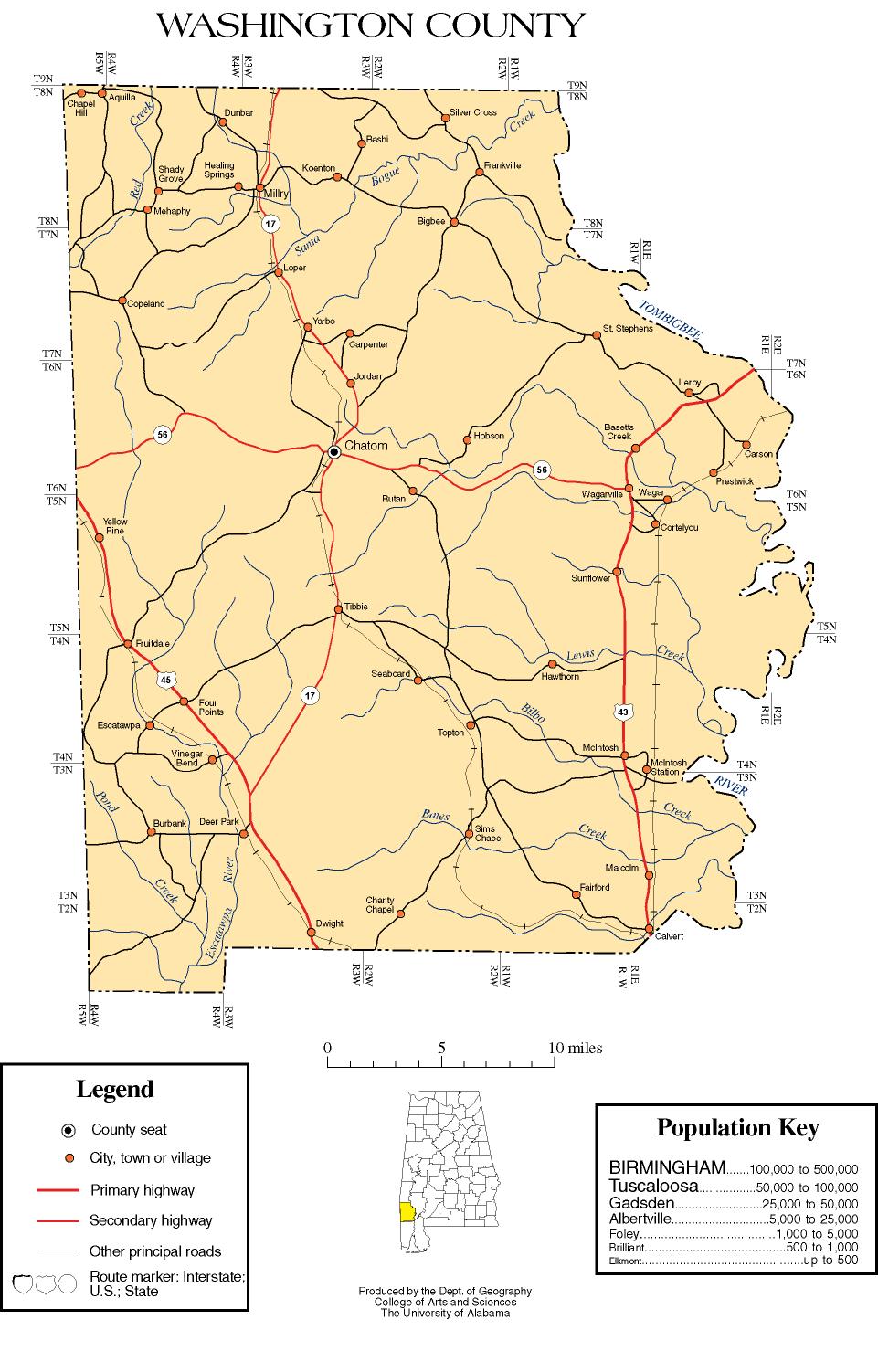
Major highways
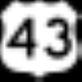
 U.S. Highway 43
 U.S. Highway 45
 State Route 17State Route 1 (Alabama)U.S. Highway 431 , internally designated by the Alabama Department of Transportation as State Route 1 , is a major north–south state highway across the eastern part of the U.S. state of Alabama...
 State Route 56
Adjacent counties
- Choctaw CountyChoctaw County, AlabamaChoctaw County is a county of the U.S. state of Alabama. It was established on December 29, 1847 and named for the Choctaw tribe of American Indians. As of 2010 the population was 13,859. The county seat is Butler.- History :...
(north) - Clarke CountyClarke County, Alabama-2010:Whereas according to the 2010 U.S. Census Bureau:*54.5% White*43.9% Black*0.4% Native American*0.3% Asian*0.0% Native Hawaiian or Pacific Islander*0.7% Two or more races*1.0% Hispanic or Latino -2000:...
(east) - Baldwin CountyBaldwin County, Alabama-2010:Whereas according to the 2010 U.S. Census Bureau:*85.7% White*9.4% Black*0.7% Native American*0.7% Asian*0.0% Native Hawaiian or Pacific Islander*1.5% Two or more races*4.4% Hispanic or Latino -2000:...
(southeast) - Mobile CountyMobile County, AlabamaMobile County[p] is a county of the U.S. state of Alabama. Its name is in honor of a tribe of Indians, the Maubila tribe . As of 2011, its population was 415,704. Its county seat is Mobile, Alabama...
(south) - Greene County, MississippiGreene County, Mississippi-Demographics:As of the census of 2000, there were 13,299 people, 4,148 households, and 3,152 families residing in the county. The population density was 19 people per square mile . There were 4,947 housing units at an average density of 7 per square mile...
(southwest) - Wayne County, MississippiWayne County, Mississippi-Demographics:As of the census of 2000, there were 21,216 people, 7,857 households, and 5,853 families residing in the county. The population density was 26 people per square mile . There were 9,049 housing units at an average density of 11 per square mile...
(northwest)
Demographics
2010
Whereas according to the 2010 U.S. Census Bureau:- 65.5% WhiteWhite AmericanWhite Americans are people of the United States who are considered or consider themselves White. The United States Census Bureau defines White people as those "having origins in any of the original peoples of Europe, the Middle East, or North Africa...
- 24.9% BlackAfrican AmericanAfrican Americans are citizens or residents of the United States who have at least partial ancestry from any of the native populations of Sub-Saharan Africa and are the direct descendants of enslaved Africans within the boundaries of the present United States...
- 8.0% Native AmericanNative Americans in the United StatesNative Americans in the United States are the indigenous peoples in North America within the boundaries of the present-day continental United States, parts of Alaska, and the island state of Hawaii. They are composed of numerous, distinct tribes, states, and ethnic groups, many of which survive as...
- 0.1% AsianAsian AmericanAsian Americans are Americans of Asian descent. The U.S. Census Bureau definition of Asians as "Asian” refers to a person having origins in any of the original peoples of the Far East, Southeast Asia, or the Indian subcontinent, including, for example, Cambodia, China, India, Indonesia, Japan,...
- 0.0% Native Hawaiian or Pacific IslanderPacific Islander AmericanPacific Islander Americans, also known as Oceanian Americans, are residents of the United States with original ancestry from Oceania. They represent the smallest racial group counted in the United States census of 2000. They numbered 874,000 people or 0.3 percent of the United States population...
- 1.2% Two or more racesMultiracial AmericanMultiracial Americans, US residents who identify themselves as of "two or more races", were numbered at around 9 million, or 2.9% of the population, in the census of 2010. However there is considerable evidence that the real number is far higher. Prior to the mid-20th century many people hid their...
- 0.9% Hispanic or LatinoHispanic and Latino AmericansHispanic or Latino Americans are Americans with origins in the Hispanic countries of Latin America or in Spain, and in general all persons in the United States who self-identify as Hispanic or Latino.1990 Census of Population and Housing: A self-designated classification for people whose origins...
(of any race)
2000
As of the censusCensus
A census is the procedure of systematically acquiring and recording information about the members of a given population. It is a regularly occurring and official count of a particular population. The term is used mostly in connection with national population and housing censuses; other common...
of 2000, there were 18,097 people, 6,705 households, and 5,042 families residing in the county. The population density
Population density
Population density is a measurement of population per unit area or unit volume. It is frequently applied to living organisms, and particularly to humans...
was 17 people per square mile (6/km2). There were 8,123 housing units at an average density of 8 per square mile (3/km2). The racial makeup of the county was 64.98% White
Race (United States Census)
Race and ethnicity in the United States Census, as defined by the Federal Office of Management and Budget and the United States Census Bureau, are self-identification data items in which residents choose the race or races with which they most closely identify, and indicate whether or not they are...
, 26.89% Black
Race (United States Census)
Race and ethnicity in the United States Census, as defined by the Federal Office of Management and Budget and the United States Census Bureau, are self-identification data items in which residents choose the race or races with which they most closely identify, and indicate whether or not they are...
or African American
Race (United States Census)
Race and ethnicity in the United States Census, as defined by the Federal Office of Management and Budget and the United States Census Bureau, are self-identification data items in which residents choose the race or races with which they most closely identify, and indicate whether or not they are...
, 7.12% Native American
Race (United States Census)
Race and ethnicity in the United States Census, as defined by the Federal Office of Management and Budget and the United States Census Bureau, are self-identification data items in which residents choose the race or races with which they most closely identify, and indicate whether or not they are...
, 0.06% Asian
Race (United States Census)
Race and ethnicity in the United States Census, as defined by the Federal Office of Management and Budget and the United States Census Bureau, are self-identification data items in which residents choose the race or races with which they most closely identify, and indicate whether or not they are...
, 0.03% Pacific Islander
Race (United States Census)
Race and ethnicity in the United States Census, as defined by the Federal Office of Management and Budget and the United States Census Bureau, are self-identification data items in which residents choose the race or races with which they most closely identify, and indicate whether or not they are...
, 0.05% from other races
Race (United States Census)
Race and ethnicity in the United States Census, as defined by the Federal Office of Management and Budget and the United States Census Bureau, are self-identification data items in which residents choose the race or races with which they most closely identify, and indicate whether or not they are...
, and 0.87% from two or more races. 0.88% of the population were Hispanic
Race (United States Census)
Race and ethnicity in the United States Census, as defined by the Federal Office of Management and Budget and the United States Census Bureau, are self-identification data items in which residents choose the race or races with which they most closely identify, and indicate whether or not they are...
or Latino
Race (United States Census)
Race and ethnicity in the United States Census, as defined by the Federal Office of Management and Budget and the United States Census Bureau, are self-identification data items in which residents choose the race or races with which they most closely identify, and indicate whether or not they are...
of any race.
There were 6,705 households out of which 37.90% had children under the age of 18 living with them, 59.10% were married couples
Marriage
Marriage is a social union or legal contract between people that creates kinship. It is an institution in which interpersonal relationships, usually intimate and sexual, are acknowledged in a variety of ways, depending on the culture or subculture in which it is found...
living together, 12.50% had a female householder with no husband present, and 24.80% were non-families. 22.80% of all households were made up of individuals and 10.10% had someone living alone who was 65 years of age or older. The average household size was 2.69 and the average family size was 3.17.
In the county the population was spread out with 28.70% under the age of 18, 8.60% from 18 to 24, 27.40% from 25 to 44, 22.90% from 45 to 64, and 12.40% who were 65 years of age or older. The median age was 35 years. For every 100 females there were 96.10 males. For every 100 females age 18 and over, there were 91.10 males.
The median income for a household in the county was $30,815, and the median income for a family was $37,881. Males had a median income of $35,237 versus $18,337 for females. The per capita income
Per capita income
Per capita income or income per person is a measure of mean income within an economic aggregate, such as a country or city. It is calculated by taking a measure of all sources of income in the aggregate and dividing it by the total population...
for the county was $14,081. About 14.80% of families and 18.50% of the population were below the poverty line, including 21.50% of those under age 18 and 22.70% of those age 65 or over.
Cities and towns
- ChatomChatom, AlabamaChatom is a town in Washington County, Alabama, United States. At the 2000 census the population was 1,193. The city is the county seat of Washington County.-Geography:Chatom is located at .According to the U.S...
- Deer ParkDeer Park, AlabamaDeer Park is an unincorporated community and census-designated place in Washington County, Alabama, United States. It had a population of 188 at the 2010 census. Deer Park is south-southwest of Chatom. Deer Park has a post office with ZIP code 36529....
- Fruitdale
- LeroyLeroy, AlabamaLeroy is a census-designated place located in Washington County, Alabama, around north of Mobile. As of the 2010 census, its population was 911. Leroy has a class 2A K-12 high school . Leroy was once a thriving farm community, serving as home to as many as 40 farming families. However, over the...
- Saint Stephens
- WagarvilleWagarville, AlabamaWagarville is an unincorporated community in Washington County, Alabama, United States. As of 2010, the population of the area was 3,353....
- McIntoshMcIntosh, AlabamaMcIntosh is a town located in Washington County, Alabama, along U.S. Highway 43. It is 12½ miles south of Wagarville and north of Mobile. It was named for Alexander McIntosh, a prominent Creek chief of the nineteenth century...
- MillryMillry, AlabamaMillry is a town in Washington County, Alabama, United States. The population was 615 at the 2000 census.-Geography:Millry is located at .According to the U.S...
- Vinegar BendVinegar Bend, AlabamaVinegar Bend is an unincorporated census-designated place in Washington County, Alabama. Vinegar Bend is south-southwest of Chatom. As of the 2010 census, its population was 192. Vinegar Bend had a post office with ZIP code 36584 until it was closed July 1, 2010. When the bridge on the "main" road...
- Tibbie
- HobsonHobsonHobson may refer to:People with the surname Hobson:*Hobson In places:* Hobson, County Durham, a village in England* Hobson, Montana, United States* Hobson, Texas, United States...
Schools/Education
Current Superintendent: Tim SavageThe Washington County School system includes:
- Chatom Elementary School
- Fruitdale High SchoolFruitdale High SchoolFruitdale High School , is a small 1A high school in Fruitdale, Alabama. The school teaches grades K-12. The school's colors are purple and gold. The school mascot is the pirate...
- Leroy High School
- McIntosh Elementary School
- McIntosh High School
- Washington County High SchoolWashington County High School (Alabama)Washington County High School, or WCHS, is a 3A high school in Chatom, Alabama. The campus is also the site of Chatom Middle School, which is grades 5-8. It is the largest school in Washington County, with 617 students enrolled as of 2005. The mascot is a bulldog, Butch. School colors are maroon...
- Career Technical Center
- Millry High School
Places of interest
Washington County has three sites listed on the National Register of Historic PlacesNational Register of Historic Places
The National Register of Historic Places is the United States government's official list of districts, sites, buildings, structures, and objects deemed worthy of preservation...
: Andrews Chapel
Andrews Chapel (McIntosh, Alabama)
Andrews Chapel, also known as the McIntosh Log Church, is a historic Methodist church building in McIntosh, Alabama. It is one of only a few remaining log churches in the state. It had its beginning in 1860 when John C. Rush and his wife donated land for the church to the Methodist McIntosh...
in McIntosh and the Old Washington County Courthouse
St. Stephens Courthouse
The St. Stephens Courthouse, listed on the National Register of Historic Places as the Washington County Courthouse and also known as the St. Stephens Masonic Lodge, is a historic former courthouse building in St. Stephens, Alabama. The Alabama Legislature authorized construction of the building...
and Old St. Stephens Site
St. Stephens, Alabama
St. Stephens is an unincorporated census-designated place in Washington County, Alabama, United States. As of the 2010 census, its population was 495. Located near the Tombigbee River in the southwestern part of the state, it is composed of two distinct sites: Old St. Stephens and New St. Stephens....
in St. Stephens. The Washington County Museum is located in Chatom.
Notable natives or residents
- Wilmer David "Vinegar Bend" Mizell (1930–1999) was born in Vinegar Bend, Washington County. He was reared nearby in Mississippi. Mizell was elected as a three-term RepublicanRepublican Party (United States)The Republican Party is one of the two major contemporary political parties in the United States, along with the Democratic Party. Founded by anti-slavery expansion activists in 1854, it is often called the GOP . The party's platform generally reflects American conservatism in the U.S...
congressman from North CarolinaNorth CarolinaNorth Carolina is a state located in the southeastern United States. The state borders South Carolina and Georgia to the south, Tennessee to the west and Virginia to the north. North Carolina contains 100 counties. Its capital is Raleigh, and its largest city is Charlotte...
, serving from 1969-1975.
See also
- National Register of Historic Places listings in Washington County, Alabama
- Properties on the Alabama Register of Landmarks and Heritage in Washington County, Alabama
External links
- Washington County map of roads/towns (map © 2007 Univ. of AlabamaUniversity of AlabamaThe University of Alabama is a public coeducational university located in Tuscaloosa, Alabama, United States....
). - South Alabama Community Website