
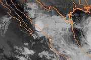
.gif)
Hurricane Debby (1988)
Encyclopedia
Hurricane Debby was the strongest tropical cyclone
to strike the Gulf Coast of Mexico since Hurricane Barry
in 1983. The eighth tropical depression, fourth tropical storm, and the first hurricane of the 1988 Atlantic hurricane season
, Debby developed from a tropical wave off the west coast of the Yucatan Peninsula
on August 31. The system slowly intensified as it tracked west-northwestward toward Mexico, eventually reaching tropical storm status on September 2. Thereafter, Debby began to rapidly strengthen, and the storm was upgraded to a hurricane later that day.
After intensifying into a hurricane, Debby made landfall near Tuxpan, Veracruz
, Mexico. Debby quickly weakened inland, however, the storm managed to remain intact over Mexico. After crossing into the eastern Pacific from Mexico, Debby became Tropical Depression Seventeen-E, which moved northwest, but sheared and later dissipated.
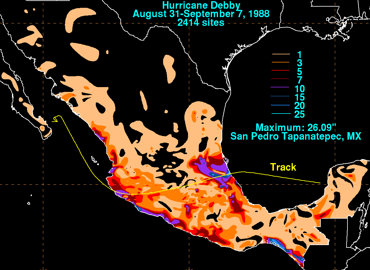
300,000 people evacuated from Mexico as Debby caused mudslides and heavy rains throughout much of the country. Debby ended up causing at least 20 fatalities, all directly related. The total damage for Mexico was not released.
. That system moved westward and became Tropical Storm Chris
days later. The leftover wave continued westward and entered the Caribbean Sea
as a disorganized center of showers. During the night of August 29, some convection came together and a low-level center appeared over the Yucatán Peninsula
. The center moved into the Bay of Campeche
and was declared a 1.5 on the Dvorak Scale
and was forecasted to become Tropical Depression Eight at that time, 1800 UTC August 30.
Banding came together and outflow patterns organized on September 1. Tropical Depression Eight moved westward and development increased, becoming Tropical Storm Debby on September 2. Debby moved towards Tuxpan, Mexico at 7 mph (11.3 km/h) while an Air Force weather reconnaissance aircraft found winds of 90 mi/h at 1500 ft (457.2 m) levels and 80 mi/h at the surface of the storm, upgrading Debby into the first hurricane of the season on September 2. At that point, Debby's small center was only 35 mi (56.3 km) from Mexico
. No more reconnaissance aircraft were deployed prior to landfall and forecasters depended on satellite imagery, which called little change in strength. Debby made landfall in Tuxpan, Mexico on September 3 at 0000 UTC. Debby weakened over Mexico's mountainous terrain, but was able to keep its bonding to become Tropical Depression Seventeen-E in the Eastern Pacific basin.
 As Hurricane Debby entered the Eastern Pacific, it became Tropical Depression Seventeen-E on September 5. Little movement occurred, leaving it stationary off the coast of Manazillo. Even though Tropical Depression Seventeen-E was a poorly organized cyclone, the possibility that it could still become a tropical storm in the small and narrow Gulf of California
was possible. Six hours after that forecast, wind shear appeared and with the close proximity to land, the forecast changed to staying as a depression.
At this point, Tropical Depression Seventeen-E was under the influence of a low-level trough and weak steering currents. A new low level center appeared on September 7, causing locally heavy rains and producing a new chance for Tropical Depression Seventeen-E to develop into a storm. Also at this point, Tropical Depression Seventeen-E was difficult to track through satellite imagery. Tropical Depression Seventeen-E came close to land, so the prediction to become a storm was doubtful and landfall was expected within 48 hours. Wind shear caused Tropical Depression to dissipate on September 8 near La Paz
.
got a five percent chance of Debby passing within 65 mi (104.6 km) of it. Over 30,000 people were evacuated, many in Veracruz.
 Reports for Tuxpan, Mexico were non-existent and all that is known there is that locally heavy flooding occurred. Only ten deaths were reported to be caused by Debby. Three were caused by a landslide in Papalanta that crushed two homes. Three storm-related deaths were reported with house-crushing landslides in Poza Rica. Four people died and sixteen were injured in a town north of Mexico City
when a mudslide crushed some homes. In Veracruz, ten other people were killed as emergency crews rushed to find shelter for 25,000 - 50,000 more that were displaced.
Debby caused power outages in Tuxpan, Poza Rica and several other places. In Poza Rica, debris caused water runoffs to be blocked. Mud and rocks blocked roads and dozens were rescued from house and car flooding. Eight communities sustained a major portion of damage.
Tropical cyclone
A tropical cyclone is a storm system characterized by a large low-pressure center and numerous thunderstorms that produce strong winds and heavy rain. Tropical cyclones strengthen when water evaporated from the ocean is released as the saturated air rises, resulting in condensation of water vapor...
to strike the Gulf Coast of Mexico since Hurricane Barry
Hurricane Barry (1983)
Hurricane Barry was the fourth tropical depression, second hurricane and named storm of the inactive 1983 Atlantic hurricane season. Developing out of a tropical wave on August 23, Barry quickly strengthened off the coast of Florida, reaching an initial peak intensity with winds of 60 mph...
in 1983. The eighth tropical depression, fourth tropical storm, and the first hurricane of the 1988 Atlantic hurricane season
1988 Atlantic hurricane season
The 1988 Atlantic hurricane season was a moderately active season that proved costly and deadly, with 15 tropical cyclones directly affecting land. The season officially began on June 1, 1988, and lasted until November 30, 1988, although activity began on May 30 when a tropical...
, Debby developed from a tropical wave off the west coast of the Yucatan Peninsula
Yucatán Peninsula
The Yucatán Peninsula, in southeastern Mexico, separates the Caribbean Sea from the Gulf of Mexico, with the northern coastline on the Yucatán Channel...
on August 31. The system slowly intensified as it tracked west-northwestward toward Mexico, eventually reaching tropical storm status on September 2. Thereafter, Debby began to rapidly strengthen, and the storm was upgraded to a hurricane later that day.
After intensifying into a hurricane, Debby made landfall near Tuxpan, Veracruz
Veracruz
Veracruz, formally Veracruz de Ignacio de la Llave officially Estado Libre y Soberano de Veracruz de Ignacio de la Llave , is one of the 31 states that, along with the Federal District, comprise the 32 federative entities of Mexico. It is divided in 212 municipalities and its capital city is...
, Mexico. Debby quickly weakened inland, however, the storm managed to remain intact over Mexico. After crossing into the eastern Pacific from Mexico, Debby became Tropical Depression Seventeen-E, which moved northwest, but sheared and later dissipated.
300,000 people evacuated from Mexico as Debby caused mudslides and heavy rains throughout much of the country. Debby ended up causing at least 20 fatalities, all directly related. The total damage for Mexico was not released.
Meteorological history
A strong tropical wave formed off of Africa's northwest coast on the August 15. As the wave moved westward a split area of the wave became Tropical Depression Seven near the Lesser AntillesLesser Antilles
The Lesser Antilles are a long, partly volcanic island arc in the Western Hemisphere. Most of its islands form the eastern boundary of the Caribbean Sea with the Atlantic Ocean, with the remainder located in the southern Caribbean just north of South America...
. That system moved westward and became Tropical Storm Chris
Tropical Storm Chris (1988)
Tropical Storm Chris was a weak tropical storm that made landfall in Georgia during the 1988 Atlantic hurricane season. The third storm of the season, Chris was one of five Atlantic storms in the year to make landfall on the United States coastline. Chris formed as a tropical depression in the...
days later. The leftover wave continued westward and entered the Caribbean Sea
Caribbean Sea
The Caribbean Sea is a sea of the Atlantic Ocean located in the tropics of the Western hemisphere. It is bounded by Mexico and Central America to the west and southwest, to the north by the Greater Antilles, and to the east by the Lesser Antilles....
as a disorganized center of showers. During the night of August 29, some convection came together and a low-level center appeared over the Yucatán Peninsula
Yucatán Peninsula
The Yucatán Peninsula, in southeastern Mexico, separates the Caribbean Sea from the Gulf of Mexico, with the northern coastline on the Yucatán Channel...
. The center moved into the Bay of Campeche
Bay of Campeche
The Bay of Campeche is the southern bight of the Gulf of Mexico. It is surrounded on three sides by the Mexican states of Campeche, Tabasco and Veracruz. It was named by Francisco Hernández de Córdoba and Antonio de Alaminos during their expedition in 1517...
and was declared a 1.5 on the Dvorak Scale
Dvorak technique
The Dvorak technique is a widely used system to subjectively estimate tropical cyclone intensity based solely on visible and infrared satellite images. Several agencies issue Dvorak intensity numbers for cyclones of sufficient intensity...
and was forecasted to become Tropical Depression Eight at that time, 1800 UTC August 30.
Banding came together and outflow patterns organized on September 1. Tropical Depression Eight moved westward and development increased, becoming Tropical Storm Debby on September 2. Debby moved towards Tuxpan, Mexico at 7 mph (11.3 km/h) while an Air Force weather reconnaissance aircraft found winds of 90 mi/h at 1500 ft (457.2 m) levels and 80 mi/h at the surface of the storm, upgrading Debby into the first hurricane of the season on September 2. At that point, Debby's small center was only 35 mi (56.3 km) from Mexico
Mexico
The United Mexican States , commonly known as Mexico , is a federal constitutional republic in North America. It is bordered on the north by the United States; on the south and west by the Pacific Ocean; on the southeast by Guatemala, Belize, and the Caribbean Sea; and on the east by the Gulf of...
. No more reconnaissance aircraft were deployed prior to landfall and forecasters depended on satellite imagery, which called little change in strength. Debby made landfall in Tuxpan, Mexico on September 3 at 0000 UTC. Debby weakened over Mexico's mountainous terrain, but was able to keep its bonding to become Tropical Depression Seventeen-E in the Eastern Pacific basin.
Gulf of California
The Gulf of California is a body of water that separates the Baja California Peninsula from the Mexican mainland...
was possible. Six hours after that forecast, wind shear appeared and with the close proximity to land, the forecast changed to staying as a depression.
At this point, Tropical Depression Seventeen-E was under the influence of a low-level trough and weak steering currents. A new low level center appeared on September 7, causing locally heavy rains and producing a new chance for Tropical Depression Seventeen-E to develop into a storm. Also at this point, Tropical Depression Seventeen-E was difficult to track through satellite imagery. Tropical Depression Seventeen-E came close to land, so the prediction to become a storm was doubtful and landfall was expected within 48 hours. Wind shear caused Tropical Depression to dissipate on September 8 near La Paz
La Paz
Nuestra Señora de La Paz is the administrative capital of Bolivia, as well as the departmental capital of the La Paz Department, and the second largest city in the country after Santa Cruz de la Sierra...
.
Preparations and Impact
Multiple warnings and/or watches were released in accordance with Hurricane Debby. The first was a tropical storm warning for Santa Cruz to Veracruz on September 2. Part of it was discontinued the same day from Santa Cruz to Punto Jerez. The rest was discontinued a few hours later. The Punto Jerez to Veracruz area was put under a hurricane warning on September 2 and was discontinued that night. Tropical storm and hurricane warnings were put in place, but were soon discontinued. Strike probabilities for land were low, however, Brownsville, TexasBrownsville, Texas
Brownsville is a city in the southernmost tip of the state of Texas, in the United States. It is located on the northern bank of the Rio Grande, directly north and across the border from Matamoros, Tamaulipas, Mexico. Brownsville is the 16th largest city in the state of Texas with a population of...
got a five percent chance of Debby passing within 65 mi (104.6 km) of it. Over 30,000 people were evacuated, many in Veracruz.
Mexico City
Mexico City is the Federal District , capital of Mexico and seat of the federal powers of the Mexican Union. It is a federal entity within Mexico which is not part of any one of the 31 Mexican states but belongs to the federation as a whole...
when a mudslide crushed some homes. In Veracruz, ten other people were killed as emergency crews rushed to find shelter for 25,000 - 50,000 more that were displaced.
Debby caused power outages in Tuxpan, Poza Rica and several other places. In Poza Rica, debris caused water runoffs to be blocked. Mud and rocks blocked roads and dozens were rescued from house and car flooding. Eight communities sustained a major portion of damage.
See also
- List of Atlantic hurricanes
- List of tropical cyclones