
East Humboldt Range
Encyclopedia
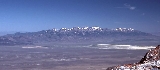
The East Humboldt Range is a line of mountains in northeastern Nevada
in the Great Basin
region of the western United States
. It located in central Elko County
in the upper watershed
of the Humboldt River
, which flows to the southwest from its source just north of the range.
The East Humboldts run north-to-south for approximately 30 miles (48.3 km). To the north are Interstate 80 and the community of Wells
, while to the south are Secret Pass, the larger Ruby Range
, and Ruby Valley
. To the east are Clover Valley and U.S. Route 93, and to the west are Starr Valley and Dennis Flats. Most of the range is included in the Humboldt National Forest. In 1989, the United States Congress
passed the Nevada Wilderness Protection Act establishing over 36000 acres (145.7 km²) as the East Humboldt Wilderness
. The range was named by the explorer John C. Frémont
for the German
naturalist Alexander von Humboldt
.
These mountains were formed by a tilted fault-block
process, with gradual slopes and valleys to the west and a steep escarpment
to the east. Both sides of the range show extensive evidence of glaciation during recent ice age
s, including U-shaped canyons, moraine
s, and steeply carved granite mountains, cliffs
, and cirque
s. All of these features can be seen from the 12 mi (19.3 km) paved road from Wells to scenic Angel Lake
.
 The range begins with a dramatic rise from a point near the source of the Humboldt River and the community of Wells, at an elevation of 5650 feet (1,722.1 m), to the summit of Greys Peak
at 10674 feet (3,253.4 m). From there, the range continues south for nearly 10 miles (16.1 km) as a high crest, staying mostly above 10000 feet (3,048 m). The center section of this crest includes Hole in the Mountain Peak
which, at 11306 feet (3,446.1 m), is the highest point in the range. The southernmost high summit of the range is Humboldt Peak
(11020 ft (3,358.9 m)), after which the main crest begins a gradual descent, forming the northeastern slopes of Secret Pass and the eastern side of North Ruby Valley.
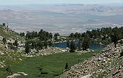 The range includes many glacial tarn
s, including Angel Lake
, Smith Lake, Greys Lake, and Winchell Lake to the north, and Lizzie's Basin, Boulder Lakes, and Steele Lake in the central section.
Hiking trails run from Secret Pass up the western side of the range all the way around to Angel Lake, from Angel Lake to nearby Smith Lake, and from a trailhead near Angel Lake down the east side of the range to Winchell Lake and Lizzie's Basin. Public access is principally found at Angel Lake, a trailhead at the west end of Secret Pass, and via a primitive road at Weeks Canyon/Lizzie's Basin.
Nevada
Nevada is a state in the western, mountain west, and southwestern regions of the United States. With an area of and a population of about 2.7 million, it is the 7th-largest and 35th-most populous state. Over two-thirds of Nevada's people live in the Las Vegas metropolitan area, which contains its...
in the Great Basin
Great Basin
The Great Basin is the largest area of contiguous endorheic watersheds in North America and is noted for its arid conditions and Basin and Range topography that varies from the North American low point at Badwater Basin to the highest point of the contiguous United States, less than away at the...
region of the western United States
United States
The United States of America is a federal constitutional republic comprising fifty states and a federal district...
. It located in central Elko County
Elko County, Nevada
-Demographics:As of the census of 2000, there were 45,291 people, 15,638 households, and 11,493 families residing in the county. The population density was 3/sq mi . There were 18,456 housing units at an average density of 1/sq mi...
in the upper watershed
Drainage basin
A drainage basin is an extent or an area of land where surface water from rain and melting snow or ice converges to a single point, usually the exit of the basin, where the waters join another waterbody, such as a river, lake, reservoir, estuary, wetland, sea, or ocean...
of the Humboldt River
Humboldt River
The Humboldt River runs through northern Nevada in the western United States. At approximately long it is the second longest river in the Great Basin, after the Bear River. It has no outlet to the ocean, but instead empties into the Humboldt Sink...
, which flows to the southwest from its source just north of the range.
The East Humboldts run north-to-south for approximately 30 miles (48.3 km). To the north are Interstate 80 and the community of Wells
Wells, Nevada
Wells is a city in Elko County, in northeast Nevada in the western United States. The population was 1,346 at the 2000 census. Wells is located at the junction of U.S. Route 93 and Interstate 80, approximately east of Elko and is part of the Elko Micropolitan Statistical Area.-History:The site...
, while to the south are Secret Pass, the larger Ruby Range
Ruby Mountains
The Ruby Mountains comprise one of the many mountain ranges of the Great Basin in the western United States. They are the predominant range in Elko County, in the northeastern section of the state of Nevada. To the north is Secret Pass and the East Humboldt Range, and from there the Rubies run...
, and Ruby Valley
Ruby Valley
Ruby Valley is a large basin located in south-central Elko and northern White Pine Counties in the northeastern section of the state of Nevada in the western United States. From Secret Pass it runs south-southwest for approximately 60 miles to Overland Pass...
. To the east are Clover Valley and U.S. Route 93, and to the west are Starr Valley and Dennis Flats. Most of the range is included in the Humboldt National Forest. In 1989, the United States Congress
United States Congress
The United States Congress is the bicameral legislature of the federal government of the United States, consisting of the Senate and the House of Representatives. The Congress meets in the United States Capitol in Washington, D.C....
passed the Nevada Wilderness Protection Act establishing over 36000 acres (145.7 km²) as the East Humboldt Wilderness
East Humboldt Wilderness
The East Humboldt Wilderness is a protected wilderness area in the East Humboldt Range of Elko County, in the northeast section of the state of Nevada in the western United States....
. The range was named by the explorer John C. Frémont
John C. Frémont
John Charles Frémont , was an American military officer, explorer, and the first candidate of the anti-slavery Republican Party for the office of President of the United States. During the 1840s, that era's penny press accorded Frémont the sobriquet The Pathfinder...
for the German
Germany
Germany , officially the Federal Republic of Germany , is a federal parliamentary republic in Europe. The country consists of 16 states while the capital and largest city is Berlin. Germany covers an area of 357,021 km2 and has a largely temperate seasonal climate...
naturalist Alexander von Humboldt
Alexander von Humboldt
Friedrich Wilhelm Heinrich Alexander Freiherr von Humboldt was a German naturalist and explorer, and the younger brother of the Prussian minister, philosopher and linguist Wilhelm von Humboldt...
.
These mountains were formed by a tilted fault-block
Fault-block mountain
Fault-block landforms are formed when large areas of bedrock are widely broken up by faults creating large vertical displacements of continental crust....
process, with gradual slopes and valleys to the west and a steep escarpment
Escarpment
An escarpment is a steep slope or long cliff that occurs from erosion or faulting and separates two relatively level areas of differing elevations.-Description and variants:...
to the east. Both sides of the range show extensive evidence of glaciation during recent ice age
Ice age
An ice age or, more precisely, glacial age, is a generic geological period of long-term reduction in the temperature of the Earth's surface and atmosphere, resulting in the presence or expansion of continental ice sheets, polar ice sheets and alpine glaciers...
s, including U-shaped canyons, moraine
Moraine
A moraine is any glacially formed accumulation of unconsolidated glacial debris which can occur in currently glaciated and formerly glaciated regions, such as those areas acted upon by a past glacial maximum. This debris may have been plucked off a valley floor as a glacier advanced or it may have...
s, and steeply carved granite mountains, cliffs
Arete (landform)
thumb|right|[[Clouds Rest]] in [[Yosemite National Park]] is an arete.An arête is a thin, almost knife-like, ridge of rock which is typically formed when two glaciers erode parallel U-shaped valleys. The arête is a thin ridge of rock that is left separating the two valleys...
, and cirque
Cirque (landform)
thumb|250 px|Two cirques with semi-permanent snowpatches in [[Abisko National Park]], [[Sweden]].A cirque or corrie is an amphitheatre-like valley head, formed at the head of a valley glacier by erosion...
s. All of these features can be seen from the 12 mi (19.3 km) paved road from Wells to scenic Angel Lake
Angel Lake
Angel Lake is a glacial tarn in the northern part of the East Humboldt Range, in central Elko County in the northeastern part of the state of Nevada. It is located at approximately , and at an elevation of 8378 feet . It has an area of approximately 13 acres , and a depth of up to 29 feet...
.
Greys Peak
Greys Peak is the northernmost summit of the East Humboldt Range of Elko County in northeastern Nevada about southwest of the community of Wells. It rises over from the Humboldt Valley, making it one of the most visually prominent peaks in the area...
at 10674 feet (3,253.4 m). From there, the range continues south for nearly 10 miles (16.1 km) as a high crest, staying mostly above 10000 feet (3,048 m). The center section of this crest includes Hole in the Mountain Peak
Hole in the Mountain Peak
Hole in the Mountain Peak is in the East Humboldt Range in northeastern Nevada, and is located east of Elko and southwest of Wells. The East Humboldts are separated from the Ruby Mountains to the south by Secret Valley. Hole in the Mountain Peak is the highest point in the East Humboldt...
which, at 11306 feet (3,446.1 m), is the highest point in the range. The southernmost high summit of the range is Humboldt Peak
Humboldt Peak (Nevada)
Humboldt Peak is the southernmost high summit in the East Humboldt Range of Elko County in northeastern Nevada. To the west are First and Second Boulder Canyons, to the south is Pole Canyon and Secret Pass, and to the east is the South Fork of Steele Creek and Clover Valley...
(11020 ft (3,358.9 m)), after which the main crest begins a gradual descent, forming the northeastern slopes of Secret Pass and the eastern side of North Ruby Valley.
Tarn (lake)
A tarn is a mountain lake or pool, formed in a cirque excavated by a glacier. A moraine may form a natural dam below a tarn. A corrie may be called a cirque.The word is derived from the Old Norse word tjörn meaning pond...
s, including Angel Lake
Angel Lake
Angel Lake is a glacial tarn in the northern part of the East Humboldt Range, in central Elko County in the northeastern part of the state of Nevada. It is located at approximately , and at an elevation of 8378 feet . It has an area of approximately 13 acres , and a depth of up to 29 feet...
, Smith Lake, Greys Lake, and Winchell Lake to the north, and Lizzie's Basin, Boulder Lakes, and Steele Lake in the central section.
Hiking trails run from Secret Pass up the western side of the range all the way around to Angel Lake, from Angel Lake to nearby Smith Lake, and from a trailhead near Angel Lake down the east side of the range to Winchell Lake and Lizzie's Basin. Public access is principally found at Angel Lake, a trailhead at the west end of Secret Pass, and via a primitive road at Weeks Canyon/Lizzie's Basin.