

Hugoton, Kansas
Encyclopedia
Hugoton is a city in and the county seat
of Stevens County
, Kansas
, United States
. As of the 2010 census, the city population was 3,904.
established a settlement in what was then west-central Seward County, Kansas
in 1885. They originally named this settlement Hugo in honor of French
writer Victor Hugo
, but then changed its name to Hugoton to distinguish it from Hugo, Colorado
.
In 1886, the Kansas Legislature
reestablished the surrounding area as Stevens County, and Gov. John Martin
designated Hugoton as the interim county seat. This set off a violent county seat war
with nearby Woodsdale
. Hugoton became the permanent county seat in 1887, but the conflict continued, culminating in the Hay Meadow Massacre
.
During the 1890s, economic decline drove many residents to leave for newly opened territories in the American Southwest
, and the population declined significantly. The Santa Fe Railway reached Hugoton in 1913, which spurred growth. Natural gas
was discovered southwest of the city in 1927, leading to the development of the Hugoton Natural Gas Area
and the transformation of Hugoton into a major center of natural gas extraction.
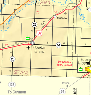 Hugoton is located at 37°10′35"N 101°20′44"W (37.176367, -101.345569) at an elevation of 3,110 feet (948 m). It lies in the High Plains
region of the Great Plains
approximately 11 miles (17.7 km) southeast of the Cimarron River. It also lies within and is the namesake of the Hugoton Natural Gas Area
. The Hugoton natural gas field
is the largest such field in North America and the second largest in the world. Located in southwestern Kansas at the intersection of U.S. Route 56
, K-25, and K-51, Hugoton is approximately 136 miles (218.9 km) north of Amarillo
, 222 miles (357.3 km) west-southwest of Wichita
, and 271 miles (436.1 km) southeast of Denver.
According to the United States Census Bureau
, the city has a total area of 1.8 square miles (4.7 km²), all of it land.
was 2,168.9 people per square mile (837.4/km²). There were 1,560 housing units at an average density of 866.7 per square mile (339.1/km²). The racial makeup of the city was 87.0% White
, 0.8% American Indian
, 0.3% African American
, 0.2% Asian
, 10.1% from somer other race, and 1.6% from two or more races. Hispanics or Latinos of any race were 36.4% of the population.
There were 1,413 households out of which 40.3% had children under the age of 18 living with them, 57.5% were married couples living together, 4.5% had a male householder with no wife present, 8.2% had a female householder with no husband present, and 29.7% were non-families. 26.8% of all households were made up of individuals, and 11.7% had someone living alone who was 65 years of age or older. The average household size was 2.71, and the average family size was 3.32.
In the city, the population was spread out with 30.3% under the age of 18, 8.8% from 18 to 24, 25.1% from 25 to 44, 22.4% from 45 to 64, and 13.4% who were 65 years of age or older. The median age was 33.6 years. For every 100 females, there were 98.8 males. For every 100 females age 18 and over, there were 96.3 males age 18 and over.
The median income for a household in the city was $50,590, and the median income for a family was $56,331. Males had a median income of $44,063 versus $30,893 for females. The per capita income
for the city was $19,317. About 11.8% of families and 14.2% of the population were below the poverty line, including 20.0% of those under age 18 and 15.3% of those age 65 or over.
form of government. The city council
consists of five members and meets on the first Monday after the 4th day of each month. The mayor
and the council members are elected for four-year terms.
210 Hugoton Public Schools provides public primary
and secondary education
with five schools in Hugoton:
Heritage Christian Academy, a Christian school, offers preschool and classes for grades K-8.
and K-25 enter Hugoton concurrently
from the north, intersecting K-51, which runs east-west, in the southern part of the city. Both U.S. 56 and K-25 then run concurrently with K-51 to the west.
Hugoton Municipal Airport
is located on the south side of U.S. 56 less than a mile west of the city. Publicly owned, it has two paved runways and is used for general aviation
.
A line of the Cimarron Valley Railroad
passes through the northwestern corner of the city.
Schools
Maps
County seat
A county seat is an administrative center, or seat of government, for a county or civil parish. The term is primarily used in the United States....
of Stevens County
Stevens County, Kansas
Stevens County is a county located in the U.S. state of Kansas. As of the 2010 census, the county population was 5,724. Its county seat is Hugoton...
, Kansas
Kansas
Kansas is a US state located in the Midwestern United States. It is named after the Kansas River which flows through it, which in turn was named after the Kansa Native American tribe, which inhabited the area. The tribe's name is often said to mean "people of the wind" or "people of the south...
, United States
United States
The United States of America is a federal constitutional republic comprising fifty states and a federal district...
. As of the 2010 census, the city population was 3,904.
History
Settlers from McPherson, KansasMcPherson, Kansas
McPherson is a city in and the county seat of McPherson County, Kansas, United States, in the central part of the state. As of the 2010 census, the city population was 13,155. The city is named after Union General James Birdseye McPherson, a Civil War general...
established a settlement in what was then west-central Seward County, Kansas
Seward County, Kansas
Seward County is a county of the U.S. state of Kansas. As of the 2010 census, the county population was 22,952. The largest city and county seat is Liberal...
in 1885. They originally named this settlement Hugo in honor of French
French people
The French are a nation that share a common French culture and speak the French language as a mother tongue. Historically, the French population are descended from peoples of Celtic, Latin and Germanic origin, and are today a mixture of several ethnic groups...
writer Victor Hugo
Victor Hugo
Victor-Marie Hugo was a Frenchpoet, playwright, novelist, essayist, visual artist, statesman, human rights activist and exponent of the Romantic movement in France....
, but then changed its name to Hugoton to distinguish it from Hugo, Colorado
Hugo, Colorado
The Town of Hugo is a Statutory Town that is the county seat of Lincoln County, Colorado, United States. The town population was 885 at the U.S...
.
In 1886, the Kansas Legislature
Kansas Legislature
The Kansas Legislature is the state legislature of the U.S. state of Kansas. It is a bicameral assembly, composed of the lower Kansas House of Representatives, composed of 125 Representatives, and the upper Kansas Senate, with 40 Senators...
reestablished the surrounding area as Stevens County, and Gov. John Martin
John Martin (Governor of Kansas)
John Alexander Martin was the tenth Governor of Kansas.Martin was born in Brownsville, Pennsylvania, a son of James and Jane Montgomery Martin. His father was a native of Maryland, and his mother a native of Pennsylvania. He was of Scots-Irish extraction, and the family was related to General...
designated Hugoton as the interim county seat. This set off a violent county seat war
County seat war
A county seat war is a phenomenon that occurred in the American West as it was being settled, although incidences elsewhere, such as in West Virginia, have been also been recorded. As new towns sprang up and county lines were drawn, there was intense competition for the status and tax benefits...
with nearby Woodsdale
Woodsdale, Kansas
Woodsdale is a ghost town in Stevens County, Kansas, United States. It was involved in a county seat war with Hugoton.-History:Samuel Newitt Wood and I. C. Price developed the town and it was named for Col. Wood. Its post office was established November 11, 1886, and the town incorporated April...
. Hugoton became the permanent county seat in 1887, but the conflict continued, culminating in the Hay Meadow Massacre
Hay Meadow Massacre
The Hay Meadow Massacre, July 25, 1888, was the most violent event of the Stevens County, Kansas, county seat fight.In July 1888, Sam Robinson, the marshal of Hugoton and a group of men supporting Hugoton for the county seat planned an outing in No Man's Land just south of the county...
.
During the 1890s, economic decline drove many residents to leave for newly opened territories in the American Southwest
Southwestern United States
The Southwestern United States is a region defined in different ways by different sources. Broad definitions include nearly a quarter of the United States, including Arizona, California, Colorado, Nevada, New Mexico, Oklahoma, Texas and Utah...
, and the population declined significantly. The Santa Fe Railway reached Hugoton in 1913, which spurred growth. Natural gas
Natural gas
Natural gas is a naturally occurring gas mixture consisting primarily of methane, typically with 0–20% higher hydrocarbons . It is found associated with other hydrocarbon fuel, in coal beds, as methane clathrates, and is an important fuel source and a major feedstock for fertilizers.Most natural...
was discovered southwest of the city in 1927, leading to the development of the Hugoton Natural Gas Area
Hugoton Natural Gas Area
Hugoton Natural Gas Area is a combination of large natural gas fields in the U.S. state of Kansas, the largest of which is the Hugoton Field. Its name is derived from the town of Hugoton, Kansas, near which the Hugoton Field was first discovered.-History:...
and the transformation of Hugoton into a major center of natural gas extraction.
Geography
High Plains (United States)
The High Plains are a subregion of the Great Plains mostly in the Western United States, but also partly in the Midwest states of Nebraska, Kansas, and South Dakota, generally encompassing the western part of the Great Plains before the region reaches the Rocky Mountains...
region of the Great Plains
Great Plains
The Great Plains are a broad expanse of flat land, much of it covered in prairie, steppe and grassland, which lies west of the Mississippi River and east of the Rocky Mountains in the United States and Canada. This area covers parts of the U.S...
approximately 11 miles (17.7 km) southeast of the Cimarron River. It also lies within and is the namesake of the Hugoton Natural Gas Area
Hugoton Natural Gas Area
Hugoton Natural Gas Area is a combination of large natural gas fields in the U.S. state of Kansas, the largest of which is the Hugoton Field. Its name is derived from the town of Hugoton, Kansas, near which the Hugoton Field was first discovered.-History:...
. The Hugoton natural gas field
Natural gas field
Oil and natural gas are produced by the same geological process according fossil fuel suggestion: anaerobic decay of organic matter deep under the Earth's surface. As a consequence, oil and natural gas are often found together...
is the largest such field in North America and the second largest in the world. Located in southwestern Kansas at the intersection of U.S. Route 56
U.S. Route 56
U.S. Route 56 is an east–west United States highway that runs for in the Midwestern United States. The highway's eastern terminus is at U.S. Route 71 in Kansas City, Missouri. Its western terminus is at Interstate 25 Business in Springer, New Mexico. Much of it follows the Santa Fe...
, K-25, and K-51, Hugoton is approximately 136 miles (218.9 km) north of Amarillo
Amarillo, Texas
Amarillo is the 14th-largest city, by population, in the state of Texas, the largest in the Texas Panhandle, and the seat of Potter County. A portion of the city extends into Randall County. The population was 190,695 at the 2010 census...
, 222 miles (357.3 km) west-southwest of Wichita
Wichita, Kansas
Wichita is the largest city in the U.S. state of Kansas.As of the 2010 census, the city population was 382,368. Located in south-central Kansas on the Arkansas River, Wichita is the county seat of Sedgwick County and the principal city of the Wichita metropolitan area...
, and 271 miles (436.1 km) southeast of Denver.
According to the United States Census Bureau
United States Census Bureau
The United States Census Bureau is the government agency that is responsible for the United States Census. It also gathers other national demographic and economic data...
, the city has a total area of 1.8 square miles (4.7 km²), all of it land.
Climate
Hugoton has a semi-arid steppe climate (Köppen BSk) with hot, dry summers and cold, dry winters. The average temperature is 55 °F (13 °C), and the average yearly precipitation is 18.4 inches (468 mm). Hugoton experiences precipitation an average of 58 days a year and snowfall an average of 4 days a year. Snowfall averages 10.4 inches (264 mm) per year. On average, the coldest month is January, the hottest month is July, and the wettest month is May. The hottest temperature recorded in Hugoton was 112 °F (44 °C) in 1980; the coldest temperature recorded was -20 °F (-29 °C) in 1959.Demographics
As of the 2010 census, there were 3,904 people, 1,413 households, and 993 families residing in the city. The population densityPopulation density
Population density is a measurement of population per unit area or unit volume. It is frequently applied to living organisms, and particularly to humans...
was 2,168.9 people per square mile (837.4/km²). There were 1,560 housing units at an average density of 866.7 per square mile (339.1/km²). The racial makeup of the city was 87.0% White
White American
White Americans are people of the United States who are considered or consider themselves White. The United States Census Bureau defines White people as those "having origins in any of the original peoples of Europe, the Middle East, or North Africa...
, 0.8% American Indian
Native Americans in the United States
Native Americans in the United States are the indigenous peoples in North America within the boundaries of the present-day continental United States, parts of Alaska, and the island state of Hawaii. They are composed of numerous, distinct tribes, states, and ethnic groups, many of which survive as...
, 0.3% African American
African American
African Americans are citizens or residents of the United States who have at least partial ancestry from any of the native populations of Sub-Saharan Africa and are the direct descendants of enslaved Africans within the boundaries of the present United States...
, 0.2% Asian
Asian American
Asian Americans are Americans of Asian descent. The U.S. Census Bureau definition of Asians as "Asian” refers to a person having origins in any of the original peoples of the Far East, Southeast Asia, or the Indian subcontinent, including, for example, Cambodia, China, India, Indonesia, Japan,...
, 10.1% from somer other race, and 1.6% from two or more races. Hispanics or Latinos of any race were 36.4% of the population.
There were 1,413 households out of which 40.3% had children under the age of 18 living with them, 57.5% were married couples living together, 4.5% had a male householder with no wife present, 8.2% had a female householder with no husband present, and 29.7% were non-families. 26.8% of all households were made up of individuals, and 11.7% had someone living alone who was 65 years of age or older. The average household size was 2.71, and the average family size was 3.32.
In the city, the population was spread out with 30.3% under the age of 18, 8.8% from 18 to 24, 25.1% from 25 to 44, 22.4% from 45 to 64, and 13.4% who were 65 years of age or older. The median age was 33.6 years. For every 100 females, there were 98.8 males. For every 100 females age 18 and over, there were 96.3 males age 18 and over.
The median income for a household in the city was $50,590, and the median income for a family was $56,331. Males had a median income of $44,063 versus $30,893 for females. The per capita income
Per capita income
Per capita income or income per person is a measure of mean income within an economic aggregate, such as a country or city. It is calculated by taking a measure of all sources of income in the aggregate and dividing it by the total population...
for the city was $19,317. About 11.8% of families and 14.2% of the population were below the poverty line, including 20.0% of those under age 18 and 15.3% of those age 65 or over.
Government
Hugoton is a city of the second class with a mayor-councilMayor-council government
The mayor–council government system, sometimes called the mayor–commission government system, is one of the two most common forms of local government for municipalities...
form of government. The city council
City council
A city council or town council is the legislative body that governs a city, town, municipality or local government area.-Australia & NZ:Because of the differences in legislation between the States, the exact definition of a City Council varies...
consists of five members and meets on the first Monday after the 4th day of each month. The mayor
Mayor
In many countries, a Mayor is the highest ranking officer in the municipal government of a town or a large urban city....
and the council members are elected for four-year terms.
Education
USDUnified school district
A unified school district or unit school district is a school district which includes both primary school and high school under the same district control....
210 Hugoton Public Schools provides public primary
Primary education in the United States
Primary education in the United States typically refers to the first six years of formal education in most jurisdictions. Primary education may also be referred to as elementary education and most schools offering these programs are referred to as elementary schools...
and secondary education
Secondary education in the United States
In most jurisdictions, secondary education in the United States refers to the last six or seven years of statutory formal education. Secondary education is generally split between junior high school or middle school, usually beginning with sixth or seventh grade , and high school, beginning with...
with five schools in Hugoton:
- Hugoton Primary School (Grades Pre-K-2)
- Hugoton Intermediate School (3-6)
- Hugoton Middle School (7-8)
- Hugoton High School (9-12)
- Hugoton Learning Academy (7-12), charter schoolCharter schoolCharter schools are primary or secondary schools that receive public money but are not subject to some of the rules, regulations, and statutes that apply to other public schools in exchange for some type of accountability for producing certain results, which are set forth in each school's charter...
Heritage Christian Academy, a Christian school, offers preschool and classes for grades K-8.
Transportation
U.S. Route 56U.S. Route 56
U.S. Route 56 is an east–west United States highway that runs for in the Midwestern United States. The highway's eastern terminus is at U.S. Route 71 in Kansas City, Missouri. Its western terminus is at Interstate 25 Business in Springer, New Mexico. Much of it follows the Santa Fe...
and K-25 enter Hugoton concurrently
Concurrency (road)
A concurrency, overlap, or coincidence in a road network is an instance of one physical road bearing two or more different highway, motorway, or other route numbers...
from the north, intersecting K-51, which runs east-west, in the southern part of the city. Both U.S. 56 and K-25 then run concurrently with K-51 to the west.
Hugoton Municipal Airport
Hugoton Municipal Airport
Hugoton Municipal Airport is a county-owned public-use airport located two nautical miles southwest of the central business district of Hugoton, a city in Stevens County, Kansas, United States.Although most U.S...
is located on the south side of U.S. 56 less than a mile west of the city. Publicly owned, it has two paved runways and is used for general aviation
General aviation
General aviation is one of the two categories of civil aviation. It refers to all flights other than military and scheduled airline and regular cargo flights, both private and commercial. General aviation flights range from gliders and powered parachutes to large, non-scheduled cargo jet flights...
.
A line of the Cimarron Valley Railroad
Cimarron Valley Railroad
The Cimarron Valley Railroad was built circa 1912 and purchased from Burlington Northern Santa Fe Railroad in February 1996. It runs over former C.V. and Manter Subdivisions of the Atchison, Topeka and Santa Fe Railroad tracks in Oklahoma, Colorado and Kansas. One line runs from Dodge City, KS...
passes through the northwestern corner of the city.
Radio
FM| Frequency | Callsign | Format | City of License City of license A city of license or community of license, in American and Canadian broadcasting, is the community that a radio station or television station is officially licensed to serve by that country's broadcast regulator.... |
Notes |
|---|---|---|---|---|
| 92.3 | K222AK | Public | Hugoton, Kansas | NPR; Translator of KANZ, Garden City, Kansas Garden City, Kansas Garden City is a city in and the county seat of Finney County, Kansas, United States. As of the 2010 census, the city population was 26,658. The city is home to Garden City Community College and the Lee Richardson Zoo, the largest zoological park in western Kansas.-History:In February 1878, James... |
| 106.7 | KFXX-FM | Mexican Regional Regional Mexican Regional Mexican is a radio format for music radio, typically defined to include Banda, Ranchera, Mariachi and Norteña. It is the most popular radio format targeting Hispanic Americans in the United States.... |
Hugoton, Kansas | Broadcasts from Garden City, Kansas Garden City, Kansas Garden City is a city in and the county seat of Finney County, Kansas, United States. As of the 2010 census, the city population was 26,658. The city is home to Garden City Community College and the Lee Richardson Zoo, the largest zoological park in western Kansas.-History:In February 1878, James... |
Notable people
Notable individuals who were born in and/or have lived in Hugoton include:- Billy DragoBilly DragoBilly Drago is an American actor known for his roles as villains in television and motion pictures.-Personal life:Drago was born William Eugene Burrows in Hugoton, Kansas to William and Gladys Burrows. He took his grandmother's maiden name as his stage name to keep from being confused with another...
, actor
Further reading
- History of the State of Kansas; William G. Cutler; A.T. Andreas Publisher; 1883. (Online HTML eBook)
- Kansas : A Cyclopedia of State History, Embracing Events, Institutions, Industries, Counties, Cities, Towns, Prominent Persons, Etc; 3 Volumes; Frank W. Blackmar; Standard Publishing Co; 944 / 955 / 824 pages; 1912. (Volume1 - Download 54MB PDF eBook),(Volume2 - Download 53MB PDF eBook), (Volume3 - Download 33MB PDF eBook)
External links
CitySchools
- USD 210, local school district
Maps
- Hugoton City Map, KDOT
- Stevens County Map, KDOT