
Highland Council wards to be created in 2007
Encyclopedia
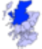
 |
| Highland council area Shown as one of the council areas of Scotland |
| 1995 to 1999 Highland Council wards 1995 to 1999 The first set of Highland Council wards was first used for Highland Council election purposes in 1995, for the first general election of the council... |
| 1999 to 2007 Highland Council wards 1999 to 2007 The second set of Highland Council wards, 80 in number, became effective for election purposes in 1999, for the second general election of the Highland Council, and were used also for the third general election in 2003... |
| 2007 |
The third set of Highland Council wards, 22 in number, became effective for election purposes in 2007, for the fourth general election
General election
In a parliamentary political system, a general election is an election in which all or most members of a given political body are chosen. The term is usually used to refer to elections held for a nation's primary legislative body, as distinguished from by-elections and local elections.The term...
of the Highland Council. The new wards were created under the Local Governance (Scotland) Act 2004
Local Governance (Scotland) Act 2004
The Local Governance Act 2004 is an Act of the Scottish Parliament which provided, inter alia, for the election of Councillors to the local authorities in Scotland by the Single Transferable Vote system....
, and are as defined in recommendations of the Local Government Boundary Commission for Scotland
Local Government Boundary Commission for Scotland
The Local Government Boundary Commission for Scotland is an independent body in Scotland created under the Local Government Act 1973...
.
The Highland Council (Comhairle na Gaidhealtachd in Gaelic) had become a local government authority in 1996, when the two-tier system of regions and districts
Regions and districts of Scotland
The local government areas of Scotland were redefined by the Local Government Act 1973 and redefined again by the Local Government etc Act 1994....
was abolished and the Highland region became a unitary council area, under the Local Government etc (Scotland) Act 1994. The first Highland Council election, however, was one year earlier, in 1995. Until 1996 councillors shadowed the regional and district councils and planned for the transfer of powers and responsibilities. Elections to the council are normally on a four-year cycle, all wards being contestable at each election.
For the periods 1995 to 1999 each of 72 wards had elected one councillor
Councillor
A councillor or councilor is a member of a local government council, such as a city council.Often in the United States, the title is councilman or councilwoman.-United Kingdom:...
by the first past the post system. For the period 1999 to 2007, each of 80 wards had elected one councillor by the same system. In 2007, single-member, first past the post wards were replaced by 22 multi-member wards, each electing three or four councillors by the single transferable vote
Single transferable vote
The single transferable vote is a voting system designed to achieve proportional representation through preferential voting. Under STV, an elector's vote is initially allocated to his or her most preferred candidate, and then, after candidates have been either elected or eliminated, any surplus or...
system, to produce a form of proportional representation
Proportional representation
Proportional representation is a concept in voting systems used to elect an assembly or council. PR means that the number of seats won by a party or group of candidates is proportionate to the number of votes received. For example, under a PR voting system if 30% of voters support a particular...
.
Until 2007 each council ward had been related to one of eight council management areas. In 2007 the council decided to replace the management areas with three new corporate management areas, named as (1) Caithness, Sutherland and Easter Ross, (2) Ross, Skye and Lochaber and (3) Inverness, Nairn and Badenoch and Strathspey, and designed for those services that could not be effectively or efficiently delivered and managed at ward level. Two of these names are also those of Westminster Parliament
Parliament of the United Kingdom
The Parliament of the United Kingdom of Great Britain and Northern Ireland is the supreme legislative body in the United Kingdom, British Crown dependencies and British overseas territories, located in London...
(House of Commons) constituencies
United Kingdom constituencies
In the United Kingdom , each of the electoral areas or divisions called constituencies elects one or more members to a parliament or assembly.Within the United Kingdom there are now five bodies with members elected by constituencies:...
, and one name is very similar to the name of another Westminster constituency, but constituency and corporate management area boundaries are different. Each corporate management area consists of a whole number of wards.
For ward-level management purposes ten wards are stand-alone areas, eleven are merged into larger areas, and one is divided between two areas. Also, seven wards are grouped into an Inverness
Inverness
Inverness is a city in the Scottish Highlands. It is the administrative centre for the Highland council area, and is regarded as the capital of the Highlands of Scotland...
city management area.
The wards are numbered as well as named.
Caithness, Sutherland and Easter Ross wards
The Caithness, Sutherland and Easter Ross corporate management area consists of seven wards represented by 23 councillors.| No | Ward | Description | Seats | Ward management area |
|---|---|---|---|---|
| 7 | Cromarty Firth | North of the Cromarty Firth Cromarty Firth The Cromarty Firth of Cromarty') is an arm of the North Sea in Scotland. It is the middle of the three sea lochs at the head of the Moray Firth: to the north lies the Dornoch Firth, and to the south the Beauly Firth.... , west of the Tain and Easter Ross ward Includes the towns of Alness Alness Alness is a town and civil parish in Ross and Cromarty, Highland, Scotland. It lies near the Cromarty Firth, with the town of Invergordon to the east and the village of Evanton to the south west... , Evanton Evanton Evanton is a large village in Easter Ross, in the Highland Council Area of Scotland. It lies between the river Sgitheach and the Allt Graad, is north of the city of Inverness, some south-west of Alness, and north-east of Dingwall. The village has a dozen or so streets, the main one being... and Invergordon Invergordon Invergordon is a town and port in Easter Ross, in Ross and Cromarty, Highland, Scotland.-History:The town is well known for the Invergordon Mutiny of 1931. More recently it was also known for the repair of oil rigs which used to be lined up in the Cromarty Firth on which the town is situated... |
4 | The ward itself |
| 5 | East Sutherland and Edderton | Includes the towns and villages of Brora Brora Brora is a village in the east of Sutherland, in the Highland area of Scotland. The village is situated where the A9 road and the Far North Line bridge the River Brora... , Dornoch Dornoch Dornoch is a town and seaside resort, and former Royal burgh in the Highlands of Scotland. It lies on the north shore of the Dornoch Firth, near to where it opens into the Moray Firth to the east... , Edderton Edderton Edderton is a village near Tain, lying on the shores of the Dornoch Firth, Easter Ross. It has approximately 388 inhabitants. It is the location of the Balblair Distillery, and of the Class III Pictish stone, the Edderton Cross Slab, which lies in the old churchyard of the village... , Golspie Golspie Golspie is a coastal village in Sutherland, Highland, Scotland. It has a population of around 1,650 people. It is located picturesquely on the shores of the North Sea in the shadow of Ben Bhraggie .... and Helmsdale Helmsdale Helmsdale is a village on the east coast of Sutherland, in the Highland council area of Scotland. The modern village was planned in 1814 to resettle communities that had been removed from the surrounding straths as part of the Highland Clearances.... Sutherland Sutherland Sutherland is a registration county, lieutenancy area and historic administrative county of Scotland. It is now within the Highland local government area. In Gaelic the area is referred to according to its traditional areas: Dùthaich 'IcAoidh , Asainte , and Cataibh... is a former local government county Counties of Scotland The counties of Scotland were the principal local government divisions of Scotland until 1975. Scotland's current lieutenancy areas and registration counties are largely based on them. They are often referred to as historic counties.... , and a former district of the Highland region Regions and districts of Scotland The local government areas of Scotland were redefined by the Local Government Act 1973 and redefined again by the Local Government etc Act 1994.... |
3 | The ward itself |
| 4 | Landward Caithness | Similar to the former local government county Counties of Scotland The counties of Scotland were the principal local government divisions of Scotland until 1975. Scotland's current lieutenancy areas and registration counties are largely based on them. They are often referred to as historic counties.... of Caithness Caithness Caithness is a registration county, lieutenancy area and historic local government area of Scotland. The name was used also for the earldom of Caithness and the Caithness constituency of the Parliament of the United Kingdom . Boundaries are not identical in all contexts, but the Caithness area is... (and to the former district of the Highland region Regions and districts of Scotland The local government areas of Scotland were redefined by the Local Government Act 1973 and redefined again by the Local Government etc Act 1994.... ) minus the Thurso and Wick wards Landward means rural, and the ward is bounded more by sea than by other wards |
4 | Caithness Caithness Caithness is a registration county, lieutenancy area and historic local government area of Scotland. The name was used also for the earldom of Caithness and the Caithness constituency of the Parliament of the United Kingdom . Boundaries are not identical in all contexts, but the Caithness area is... , covering the three wards of Landward Caithness, Thurso and Wick |
| 1 | North, West and Central Sutherland | Includes the towns and villages of Altnaharra Altnaharra -Notable persons:*Linda Norgrove, kidnapped by the Taliban in Afghanistan, and killed by a US grenade during a rescue effort.-External links:**... , Bettyhill Bettyhill Bettyhill is a village on the north coast of Scotland.Bettyhill lies on the A836 road west of Thurso and from Tongue. And 5 miles from the village of Skerray Its former fishing port was called Navermouth... , Bonar Bridge Bonar Bridge Bonar Bridge is a village on the north bank of the Kyle of Sutherland, in the Parish of Creich in the Highland council area of Scotland.The Kyle of Sutherland is a river estuary of the Rivers Oykel, Cassley, Shin and Carron that all enter the Kyle above the bridge at Bonar.The estuary and the... , Durness Durness Durness is a huge but remote parish in the northwestern Highlands of Scotland, encompassing all the land between the Moine to the East and the Gualin to the West... , Lairg Lairg Lairg is a village in Sutherland, Highland, Scotland. It has a population of about 700and is situated at the south-eastern end of Lairg is a village in [[Sutherland]], [[Highland |Highland]], [[Scotland]]... , Lochinver Lochinver Lochinver is a village on the coast in the Assynt district of Sutherland, Highland, Scotland. A few miles northeast is Loch Assynt which is the source of the River Inver which flows into Loch Inver at the village. There are 200 or so lochans in the area which makes the place very popular with... and Tongue Tongue, Highland Tongue is a coastal village in northwest Highland, Scotland, in the western part of the former county of Sutherland. It lies on the east shore above the base of the Kyle of Tongue and north of the mountains Ben Hope and Ben Loyal... Sutherland Sutherland Sutherland is a registration county, lieutenancy area and historic administrative county of Scotland. It is now within the Highland local government area. In Gaelic the area is referred to according to its traditional areas: Dùthaich 'IcAoidh , Asainte , and Cataibh... is a former local government county Counties of Scotland The counties of Scotland were the principal local government divisions of Scotland until 1975. Scotland's current lieutenancy areas and registration counties are largely based on them. They are often referred to as historic counties.... and a former district of the Highland region Regions and districts of Scotland The local government areas of Scotland were redefined by the Local Government Act 1973 and redefined again by the Local Government etc Act 1994.... |
3 | The ward itself |
| 8 | Tain and Easter Ross | Between the Cromarty Firth Cromarty Firth The Cromarty Firth of Cromarty') is an arm of the North Sea in Scotland. It is the middle of the three sea lochs at the head of the Moray Firth: to the north lies the Dornoch Firth, and to the south the Beauly Firth.... and the Dornoch Firth Dornoch Firth The Dornoch Firth is a firth on the east coast of Highland, in northern Scotland. It forms part of the boundary between Ross and Cromarty, to the south, and Sutherland, to the north.... , east of the Cromarty Firth ward Includes the town of Tain Tain Tain is a royal burgh and post town in the committee area of Ross and Cromarty, in the Highland area of Scotland.-Etymology:... and the Seaboard Villages Seaboard Villages The Seaboard Villages are three contiguous coastal villages, situated about 10 km southeast of the town of Tain in Easter Ross, Scotland. They face east onto the Moray Firth.Namely :*Hilton of Cadboll - which has the pier... Ross is a former county Counties of Scotland The counties of Scotland were the principal local government divisions of Scotland until 1975. Scotland's current lieutenancy areas and registration counties are largely based on them. They are often referred to as historic counties.... |
3 | The ward itself |
| 2 | Thurso | Urban Thurso Thurso -Facilities:Offices of the Highland Council are located in the town, as is the main campus of North Highland College, formerly Thurso College. This is one of several partner colleges which constitute the UHI Millennium Institute, and offers several certificate, diploma and degree courses from... and more rural areas around Thurso Bay Thurso Bay Thurso Bay, known also as Scrabster Bay, is a bay of Atlantic water between the points of Clairdon Head and Holborn Head on the north coast of Caithness, Scotland.... Includes Scrabster Harbour Scrabster Harbour Scrabster is a small settlement on Thurso Bay in Caithness on the north coast of Scotland. It is some 1½ miles from Thurso, 22½ miles from Wick and 112 miles from Inverness.... , but not the point of Holborn Head Holborn Head Holborn Head is a headland on the north-facing Atlantic coast of Caithness, in the Highland area of Scotland. The point of Holborn Head is at . The name Holborn appears Norse in origin, meaning hillfort, and the headland may be the Tarvedunum promotorium noted by Ptolemy... |
3 | Caithness Caithness Caithness is a registration county, lieutenancy area and historic local government area of Scotland. The name was used also for the earldom of Caithness and the Caithness constituency of the Parliament of the United Kingdom . Boundaries are not identical in all contexts, but the Caithness area is... , covering the three wards of Landward Caithness, Thurso and Wick |
| 3 | Wick | Urban Wick and more rural areas to north and south | 3 |
Inverness, Nairn and Badenoch and Strathspey wards
The Inverness, Nairn and Badenoch and Strathspey corporate management area consists of nine wards represented by 34 councillors. Also, seven of the wards, represented by 26 councillors, are grouped into an InvernessInverness
Inverness is a city in the Scottish Highlands. It is the administrative centre for the Highland council area, and is regarded as the capital of the Highlands of Scotland...
city management area with its own city committee.
Inverness wards
| No | Ward | Description | Seats | Ward management area |
|---|---|---|---|---|
| 13 | Aird and Loch Ness | Includes Loch Ness Loch Ness Loch Ness is a large, deep, freshwater loch in the Scottish Highlands extending for approximately southwest of Inverness. Its surface is above sea level. Loch Ness is best known for the alleged sightings of the cryptozoological Loch Ness Monster, also known affectionately as "Nessie"... , the town of Beauly Beauly Beauly is a town of the Scottish county of Inverness-shire, on the River Beauly, 10 miles west of Inverness by the Far North railway line. Its population was 855 in 1901... , and the village of Fort Augustus Fort Augustus Fort Augustus is a settlement in the Scottish Highlands, at the south west end of Loch Ness. The village has a population of around 646 ; its economy is heavily reliant on tourism.... Aird Aird, Inverness The Aird is an area of the County of Inverness, to the west of the City of Inverness. It is situated to the south of the River Beauly and the Beauly Firth, and to the north of Glenurquhart and the northern end of Loch Ness.... is a former district of the county of Inverness |
4 | City area 1, covering the Aird and Loch Ness ward and a southern portion of the Inverness South ward |
| 18 | Culloden and Ardersier | Includes the villages of Culloden Culloden Culloden may refer to any of the following:*Culloden, Highland, a village in Scotland**The Battle of Culloden, a battle which took place there in 1746... , Ardersier Ardersier Ardersier is a small former fishing village in the Scottish Highlands, on the Moray Firth, east of Inverness, near Fort George, and Nairn . Its name is an anglicisation of the Gaelic "Àird nan Saor", or "Headland of the joiners", one local legend being that carpenters working on the construction... and Smithton Smithton, Inverness Smithton is a residential area on the eastern outskirts of the city of Inverness, in the Highland council area of Scotland. It is located about 5 km east of the city centre, to the north-east of Westhill, and to the south-west of Culloden.It is traditionally seen as a working class area due... |
4 | City area 4, covering the Culloden and Ardersier ward and a northern portion of the Inverness South ward |
| 15 | Inverness Central | Includes Dalneigh Dalneigh Dalneigh is an area in the city of Inverness in Scotland. Located in the west of the city, it lies between the River Ness and the Caledonian Canal. The name is derived from the Gaelic word Dail an Eich, meaning 'Field of the horse'... , Glebe, Haugh, Merkinch Merkinch Merkinch is an area of the city of Inverness in the Scottish Highlands. One of the Inverness's oldest areas, it is located in the north-west of the city, flanked by the Caledonian Canal to the west and the River Ness to the east.Originally, Merkinch was home to Inverness's shipbuilding industry... and South Kessock South Kessock South Kessock is an area of the city of Inverness in Scotland.It is to the north of Merkinch and is also known, somewhat disparagingly, as the Ferry. Prior to the construction of the Kessock Bridge, the Kessock Ferry sailed between North Kessock and here.South Kessock has featured in two novels by... areas of urban Inverness Inverness Inverness is a city in the Scottish Highlands. It is the administrative centre for the Highland council area, and is regarded as the capital of the Highlands of Scotland... |
4 | City area 3, covering the two wards of Inverness Central and Inverness Millburn |
| 17 | Inverness Millburn | Includes Millburn Millburn, Inverness Millburn is an area in Inverness in the Scottish Highlands. Millburn Academy is situated in the area. The area is also known, as the name suggests, for the Mill Burn which runs through the area. Millburn Road which runs parallel to the school is one of the main access roads into the centre of... , Culcabock, Longman Longman, Inverness The Longman is an area in the city of Inverness, in Scotland. Located north of the city centre, it is bounded by the Moray Firth and River Ness and is home to the largest industrial estate in the city.... and Raigmore areas of urban Inverness Inverness Inverness is a city in the Scottish Highlands. It is the administrative centre for the Highland council area, and is regarded as the capital of the Highlands of Scotland... |
3 | City area 3, covering the two wards of Inverness Central and Inverness Millburn |
| 16 | Inverness Ness-side | Includes Drummond, Hilton and Lochardil areas of Inverness Inverness Inverness is a city in the Scottish Highlands. It is the administrative centre for the Highland council area, and is regarded as the capital of the Highlands of Scotland... , and a more rural area, east of the River Ness River Ness The River Ness is a river flowing from Loch Ness in Scotland, north to Inverness and the Moray Firth. On a hill above the river in Inverness stands Inverness Castle. The river is overlooked by the Eden Court Theatre, one of the largest theatres in Scotland. St. Andrews Cathedral also lies along... |
4 | City area 2, covering the two wards of Inverness Ness-side and Inverness West |
| 20 | Inverness South | Includes Cradlehall Cradlehall Cradlehall is a residential area in the east of Inverness, Scotland. In addition to housing, Cradlehall has a business park and a number of small businesses. The area was expanded recently with the development of Kessock View.... , Inshes and Westhill Westhill, Inverness Westhill is a commuter village, lying 3 miles southeast of Inverness, Scotland. It is situated on the eastern edge of the city, between Cradlehall and Culloden, in Inverness-shire, Scottish Highlands. It is located in the Scottish council area of Highland.The historic Culloden Battlefield lies... areas in or near urban Inverness Inverness Inverness is a city in the Scottish Highlands. It is the administrative centre for the Highland council area, and is regarded as the capital of the Highlands of Scotland... , and the village of Tomatin Tomatin Tomatin is a small village on the River Findhorn in Strathdearn in the Scottish Highlands about south of the city of Inverness. The name derives from the Scottish Gaelic name Tom-Ah-Tin . The river Findhorn rises at Coignafearn, a large game estate near Tomatin, and then passes through Tomatin... , on the River Findhorn River Findhorn The River Findhorn is one of the longest rivers in Scotland. Located in the north east, it flows into the Moray Firth on the north coast. It has one of the largest non-firth estuaries in Scotland.... |
4 | Divided between city area 1, covering the Aird and Loch Ness ward and a southern portion of the Inverness South ward, and city area 4, covering the Culloden and Ardersier ward and a northern portion of the Inverness South ward |
| 14 | Inverness West | Includes Kinmylies Kinmylies Kinmylies is an area in the west end of the city of Inverness in the Scottish Highlands. The area sits between the side of the hill Creag Phadraig ; and the Caledonian Canal. The local football team was Caledonian F.C... and Scorguie areas of urban Inverness Inverness Inverness is a city in the Scottish Highlands. It is the administrative centre for the Highland council area, and is regarded as the capital of the Highlands of Scotland... , and a more rural area, west of the River Ness River Ness The River Ness is a river flowing from Loch Ness in Scotland, north to Inverness and the Moray Firth. On a hill above the river in Inverness stands Inverness Castle. The river is overlooked by the Eden Court Theatre, one of the largest theatres in Scotland. St. Andrews Cathedral also lies along... |
3 | City area 2, covering the two wards of Inverness Ness-side and Inverness West |
Other wards
| No | Ward | Description | Seats | Ward management area |
|---|---|---|---|---|
| 21 | Badenoch and Strathspey | Includes the towns and villages of Aviemore Aviemore Aviemore is a town and tourist resort, situated within the Cairngorms National Park in the Highlands of Scotland. It is in the Badenoch and Strathspey committee area, within the Highland council area. The town is popular for skiing and other winter sports, and for hill-walking in the Cairngorm... , Carrbridge Carrbridge Carrbridge is a village in Badenoch and Strathspey in the Scottish Highlands. It lies off the A9 road on the A938 road, west of Skye of Curr, southeast of Findhom Bridge, near Bogroy.It has the oldest stone bridge in the Highlands and nearby ancient pine forest contains the Landmark Forest... , Cromdale Cromdale Cromdale is a village in Highland, Scotland and one of the ancient parishes which formed the combined ecclesiastical parish of "Cromdale, Inverallan and Advie" in Morayshire.... , Grantown-on-Spey Grantown-on-Spey Grantown-on-Spey is a town in the Highland Council Area in Scotland.It was founded in 1765 as a planned settlement on a low plateau at Freuchie beside the river Spey at the northern edge of the Cairngorm mountains, about 20 miles South East of Inverness .It is the main town in what was the... , Kingussie Kingussie Kingussie is a small town in the Highland region of Scotland. It is one settlement in the Highland Council ward of Badenoch and Strathspey, and is the capital of the district of Badenoch. It lies beside the A9 road, although the old route of the A9 serves as the town's main street... and Newtonmore Newtonmore Newtonmore is a village in the Highland council area of Scotland. It has a population of about 1000. The village is only a few miles from a location that is claimed to be the exact geographical centre of Scotland... Badenoch and Strathspey Badenoch and Strathspey Badenoch and Strathspey as a local government district 1975 to 1996Badenoch and Strathspey is a local government ward of the Highland council area and a ward management area of the Highland Council in Scotland... is also a former district of the Highland region Regions and districts of Scotland The local government areas of Scotland were redefined by the Local Government Act 1973 and redefined again by the Local Government etc Act 1994.... |
4 | The ward itself |
| 19 | Nairn | Urban Nairn Nairn Nairn is a town and former burgh in the Highland council area of Scotland. It is an ancient fishing port and market town around east of Inverness... and more rural areas Within the former county Counties of Scotland The counties of Scotland were the principal local government divisions of Scotland until 1975. Scotland's current lieutenancy areas and registration counties are largely based on them. They are often referred to as historic counties.... of Nairn (also known as Nairnshire), and former Nairn district of the Highland region Regions and districts of Scotland The local government areas of Scotland were redefined by the Local Government Act 1973 and redefined again by the Local Government etc Act 1994.... |
4 | The ward itself |
Ross, Skye and Lochaber wards
The Ross, Skye and Lochaber corporate management area consists of six wards represented by 23 councillors.| No | Ward | Description | Seats | Ward management area |
|---|---|---|---|---|
| 10 | Black Isle | A Black Isle Black Isle The Black Isle is an eastern area of the Highland local government council area of Scotland, within the county of Ross and Cromarty. The name nearly always includes the article "the".... area, between the Beauly Firth Beauly Firth The Beauly Firth is a firth in northern Scotland. It is effectively a continuation of the Moray Firth westward, and is bounded at one end by Beauly and at the other by Inverness . The Kessock Ferry has crossed at the eastern end since the 15th Century... and the Cromarty Firth Cromarty Firth The Cromarty Firth of Cromarty') is an arm of the North Sea in Scotland. It is the middle of the three sea lochs at the head of the Moray Firth: to the north lies the Dornoch Firth, and to the south the Beauly Firth.... Includes the towns of Cromarty Cromarty The Royal Burgh of Cromarty is a burgh in Ross and Cromarty, Highland, Scotland.-History:It was previously the county town of the former county of Cromartyshire... and Fortrose Fortrose Fortrose is a burgh in the Scottish Highlands, located on the Moray Firth, approximately ten kilometres north east of Inverness. The town is known for its ruined 13th century cathedral, and as the home of the Brahan Seer. In the Middle Ages it was the seat of the bishopric of Ross... |
4 | The ward itself |
| 12 | Caol and Mallaig | Includes the Caol Caol Caol is a village near Fort William, in the Highland council area of Scotland. It is about 2.5 km north of Fort William town centre, on the shore of Loch Linnhe, and within the parish of Kilmallie.... area of the town of Fort William, the town of Mallaig Mallaig Mallaig ; is a port in Lochaber, on the west coast of the Highlands of Scotland. The local railway station, Mallaig, is the terminus of the West Highland railway line , completed in 1901, and the town is linked to Fort William by the A830 road – the "Road to the Isles".The village of Mallaig... , and the Small Isles Small Isles The Small Isles are a small archipelago of islands in the Inner Hebrides, off the west coast of Scotland. They lie south of Skye and north of Mull and Ardnamurchan – the most westerly point of mainland Scotland.The four main islands are Canna, Rùm, Eigg and Muck... A boundary divides the town of Fort William between the Fort William and Ardnamurchan ward and the Caol and Mallaig ward |
3 | Lochaber Lochaber District of Lochaber 1975 to 1996Highland council area shown as one of the council areas of ScotlandLochaber is one of the 16 ward management areas of the Highland Council of Scotland and one of eight former local government districts of the two-tier Highland region... , covering the two wards of Fort William and Ardnamurchan, and Caol and Mallaig |
| 9 | Dingwall and Seaforth | Includes the towns of Dingwall Dingwall Dingwall is a town and former royal burgh in the Highland council area of Scotland. It has a population of 5,026. It was formerly an east-coast harbor but now lies inland. Dingwall Castle was once the biggest castle north of Stirling. On the town's present-day outskirts lies Tulloch Castle, parts... , Conon Bridge Conon Bridge Conon Bridge is a small village in the Highland region of Scotland. The current Gaelic name is likely a neologism: the bridge wasn't built until the early 19th century and some early gravestones show the name sgudal or scuddle... , and Muir of Ord Muir of Ord Muir of Ord is a village in Highland, Scotland. It is situated near the western boundary of the Black Isle, about 20 km west of the city of Inverness, and 10 km south of Dingwall... |
4 | The ward itself |
| 11 | Eilean a' Cheò | Islands, including Skye and Raasay Raasay Raasay is an island between the Isle of Skye and the mainland of Scotland. It is separated from Skye by the Sound of Raasay and from Applecross by the Inner Sound. It is most famous for being the birthplace of the poet Sorley MacLean, an important figure in the Scottish literary renaissance... |
4 | The ward itself |
| 22 | Fort William and Ardnamurchan | Includes part of the town of Fort William (south of Caol Caol Caol is a village near Fort William, in the Highland council area of Scotland. It is about 2.5 km north of Fort William town centre, on the shore of Loch Linnhe, and within the parish of Kilmallie.... ), the villages of Ballachulish Ballachulish The village of Ballachulish in Lochaber, Highland, Scotland, is centred around former slate quarries. The name Ballachulish was more correctly applied to the area now called North Ballachulish, to the north of Loch Leven, but was usurped for the quarry villages at East Laroch and West Laroch,... and Kinlochleven Kinlochleven Kinlochleven is a village in Lochaber, in the Scottish Highlands and lies at the eastern end of Loch Leven, a sea loch cutting into the western Scottish Highlands. To the north lie the Mamores ridge; to the south lie the mountains flanking Glen Coe... , and the Ardnamurchan Ardnamurchan Ardnamurchan is a peninsula in Lochaber, Highland, Scotland, noted for being very unspoilt and undisturbed. Its remoteness is accentuated by the main access route being a single track road for much of its length.-Geography:... peninsula A boundary divides the town of Fort William between the Fort William and Ardnamurchan ward and the Caol and Mallaig ward Loch Linnhe Loch Linnhe Loch Linnhe is a sea loch on the west coast of Scotland.... divides the Fort William and Ardnamurchan ward into two distinct areas |
4 | Lochaber Lochaber District of Lochaber 1975 to 1996Highland council area shown as one of the council areas of ScotlandLochaber is one of the 16 ward management areas of the Highland Council of Scotland and one of eight former local government districts of the two-tier Highland region... , covering the two wards of Fort William and Ardnamurchan, and Caol and Mallaig |
| 6 | Wester Ross, Strathpeffer and Lochalsh | Includes the towns and villages of Gairloch Gairloch Gairloch is a village, civil parish and community on the shores of Loch Gairloch on the northwest coast of Scotland. A popular tourist destination in the summer months, Gairloch has a golf course, a small museum, several hotels, a community centre, a leisure centre with sports facilities, a local... , Lochalsh, Strathpeffer Strathpeffer Strathpeffer is a village and former spa town in Ross and Cromarty, Highland, Scotland, with a population of 1,469.-Geography:It lies in a glen 5 miles west of Dingwall, with varying elevation from 200 to 400 feet above sea level... and Ullapool Ullapool Ullapool is a small town of around 1,300 inhabitants in Ross and Cromarty, Highland, Scotland. Despite its small size, it is the largest settlement for many miles around, and is a major tourist destination of Scotland. The North Atlantic Drift passes by Ullapool, bringing moderate temperatures... Ross is a former county Counties of Scotland The counties of Scotland were the principal local government divisions of Scotland until 1975. Scotland's current lieutenancy areas and registration counties are largely based on them. They are often referred to as historic counties.... |
4 | The ward itself |