
Hatch, New Mexico
Encyclopedia
Hatch is a village in Doña Ana County
, New Mexico
, United States
. The population was 1,673 at the 2000 census. It is part of the Las Cruces
Metropolitan Statistical Area. The town is experiencing moderate growth, along with its outliers of Salem
, Arrey
, Derry, and Rincon
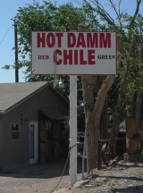
. Hatch is widely known for its famous Hatch Green Chiles.
, who was then commander of the New Mexico Military District.
is best prepared by roasting over an open flame. Each year during chile season, dozens of chile vendors can be found lining the streets of Hatch roasting the local chile.
The Hatch Chile Festival is an annual event that occurs each Labor Day. This event attracts people world wide to a place known as the chile capital of the world. The small town has accommodated up to 30,000 people for this event. This small farming community is known world wide for raising very good chile. Other crops such as onion
s, cotton
, and corn
are also raised there. Irrigation
of local farms is accomplished by water wells as well as irrigation ditches which divert water from the Rio Grande
and two lakes approximately 20 miles north of Hatch named Caballo (Spanish
for "horse") and Elephant Butte Reservoir
(named after a rock formation in the middle of the lake that looks similar to an elephant).
Hatch is 40 miles north of Las Cruces, New Mexico
, on Interstate 25
, and 34 miles south of Spaceport America
, a new purpose-built spaceport
being built by the New Mexico Spaceport Authority with State and county funding.
According to the United States Census Bureau
, the village has a total area of 3.1 square miles (8 km²), all of it land.
The village is located just off Interstate 25
about 40 miles northwest of Las Cruces, NM
and approximately 80 miles northwest of El Paso, TX
.
Hatch and the surrounding area (Doña Ana County) was hard hit by flooding in Summer 2006. The area was declared a disaster (#1659) and FEMA
established a Disaster Recovery Center in the city.
of 2000, there were 1,673 people, 538 households, and 402 families residing in the village. The population density
was 540.2 people per square mile (208.4/km²). There were 635 housing units at an average density of 205.0 per square mile (79.1/km²). The racial makeup of the village was 46.03% White, 0.36% African American, 0.96% Native American, 0.24% Pacific Islander, 50.03% from other races
, and 2.39% from two or more races. Hispanic or Latino of any race were 79.20% of the population.
There were 538 households out of which 43.7% had children under the age of 18 living with them, 56.7% were married couples
living together, 14.3% had a female householder with no husband present, and 25.1% were non-families. 20.6% of all households were made up of individuals and 11.0% had someone living alone who was 65 years of age or older. The average household size was 3.11 and the average family size was 3.63.
In the village the population was spread out with 35.7% under the age of 18, 9.7% from 18 to 24, 24.3% from 25 to 44, 17.9% from 45 to 64, and 12.3% who were 65 years of age or older. The median age was 30 years. For every 100 females there were 94.5 males. For every 100 females age 18 and over, there were 93.9 males.
The median income for a household in the village was $21,250, and the median income for a family was $23,819. Males had a median income of $21,923 versus $17,188 for females. The per capita income
for the village was $14,619. About 28.5% of families and 34.5% of the population were below the poverty line, including 50.1% of those under age 18 and 14.6% of those age 65 or over.
Doña Ana County, New Mexico
-2010:Whereas according to the 2010 U.S. Census Bureau:*74.1% White*1.7% Black*1.5% Native American*1.1% Asian*0.1% Native Hawaiian or Pacific Islander*3.0% Two or more races*18.5% Other races*65.7% Hispanic or Latino -2000:...
, New Mexico
New Mexico
New Mexico is a state located in the southwest and western regions of the United States. New Mexico is also usually considered one of the Mountain States. With a population density of 16 per square mile, New Mexico is the sixth-most sparsely inhabited U.S...
, United States
United States
The United States of America is a federal constitutional republic comprising fifty states and a federal district...
. The population was 1,673 at the 2000 census. It is part of the Las Cruces
Las Cruces, New Mexico
Las Cruces, also known as "The City of the Crosses", is the county seat of Doña Ana County, New Mexico, United States. The population was 97,618 in 2010 according to the 2010 Census, making it the second largest city in the state....
Metropolitan Statistical Area. The town is experiencing moderate growth, along with its outliers of Salem
Salem, New Mexico
Salem is a census-designated place in Doña Ana County, New Mexico, United States. The population was 795 at the 2000 census. It is part of the Las Cruces Metropolitan Statistical Area.-Geography:Salem is located at ....
, Arrey
Arrey, New Mexico
Arrey is an unincorporated town in Sierra County, New Mexico, United States. It lies about 22 miles south of Truth or Consequences....
, Derry, and Rincon
Rincon, New Mexico
Rincon is a census-designated place in Doña Ana County, New Mexico, in the United States. As of the 2000 census, the CDP population was 220...
. Hatch is widely known for its famous Hatch Green Chiles.
History
Hatch was originally settled as Santa Barbara in 1851, however Apache raids drove the farmers away until 1853 when the nearby Fort Thorn was established. When Fort Thorn closed in 1860, the town had to be abandoned again. It was not until 1875 that it was re-occupied and at that time it was re-named for Indian fighter Edward HatchEdward Hatch
Edward Hatch was a career American soldier who served as a general in the Union Army during the American Civil War...
, who was then commander of the New Mexico Military District.
Economy
Hatch chileHatch chile
Hatch chile refers to varieties of species of the genus Capsicum which are grown in and around Hatch, New Mexico. Most of these varieties of chile have been developed at New Mexico State University over the last 130 years...
is best prepared by roasting over an open flame. Each year during chile season, dozens of chile vendors can be found lining the streets of Hatch roasting the local chile.
The Hatch Chile Festival is an annual event that occurs each Labor Day. This event attracts people world wide to a place known as the chile capital of the world. The small town has accommodated up to 30,000 people for this event. This small farming community is known world wide for raising very good chile. Other crops such as onion
Onion
The onion , also known as the bulb onion, common onion and garden onion, is the most widely cultivated species of the genus Allium. The genus Allium also contains a number of other species variously referred to as onions and cultivated for food, such as the Japanese bunching onion The onion...
s, cotton
Cotton
Cotton is a soft, fluffy staple fiber that grows in a boll, or protective capsule, around the seeds of cotton plants of the genus Gossypium. The fiber is almost pure cellulose. The botanical purpose of cotton fiber is to aid in seed dispersal....
, and corn
Maize
Maize known in many English-speaking countries as corn or mielie/mealie, is a grain domesticated by indigenous peoples in Mesoamerica in prehistoric times. The leafy stalk produces ears which contain seeds called kernels. Though technically a grain, maize kernels are used in cooking as a vegetable...
are also raised there. Irrigation
Irrigation
Irrigation may be defined as the science of artificial application of water to the land or soil. It is used to assist in the growing of agricultural crops, maintenance of landscapes, and revegetation of disturbed soils in dry areas and during periods of inadequate rainfall...
of local farms is accomplished by water wells as well as irrigation ditches which divert water from the Rio Grande
Rio Grande
The Rio Grande is a river that flows from southwestern Colorado in the United States to the Gulf of Mexico. Along the way it forms part of the Mexico – United States border. Its length varies as its course changes...
and two lakes approximately 20 miles north of Hatch named Caballo (Spanish
Spanish language
Spanish , also known as Castilian , is a Romance language in the Ibero-Romance group that evolved from several languages and dialects in central-northern Iberia around the 9th century and gradually spread with the expansion of the Kingdom of Castile into central and southern Iberia during the...
for "horse") and Elephant Butte Reservoir
Elephant Butte Reservoir
Elephant Butte Reservoir is a reservoir on the Rio Grande in the U.S. state of New Mexico, north of Truth or Consequences. It is impounded by Elephant Butte Dam and is the largest reservoir in New Mexico...
(named after a rock formation in the middle of the lake that looks similar to an elephant).
Hatch is 40 miles north of Las Cruces, New Mexico
Las Cruces, New Mexico
Las Cruces, also known as "The City of the Crosses", is the county seat of Doña Ana County, New Mexico, United States. The population was 97,618 in 2010 according to the 2010 Census, making it the second largest city in the state....
, on Interstate 25
Interstate 25
Interstate 25 is an Interstate Highway in the western United States. It is primarily a north–south highway. I-25 stretches from Interstate 10 at Las Cruces, New Mexico, , to Interstate 90 in Buffalo, Wyoming, .Interstate 25 is the main north–south expressway through...
, and 34 miles south of Spaceport America
Spaceport America
Spaceport America is a spaceport located in the Jornada del Muerto desert basin in New Mexico, United States. It lies north of El Paso, north of Las Cruces, east of Truth or Consequences...
, a new purpose-built spaceport
Spaceport
A spaceport or cosmodrome is a site for launching spacecraft, by analogy with seaport for ships or airport for aircraft. The word spaceport, and even more so cosmodrome, has traditionally been used for sites capable of launching spacecraft into orbit around Earth or on interplanetary trajectories...
being built by the New Mexico Spaceport Authority with State and county funding.
Geography
Hatch is located at 32°39′54"N 107°9′31"W (32.664919, -107.158668).According to the United States Census Bureau
United States Census Bureau
The United States Census Bureau is the government agency that is responsible for the United States Census. It also gathers other national demographic and economic data...
, the village has a total area of 3.1 square miles (8 km²), all of it land.
The village is located just off Interstate 25
Interstate 25
Interstate 25 is an Interstate Highway in the western United States. It is primarily a north–south highway. I-25 stretches from Interstate 10 at Las Cruces, New Mexico, , to Interstate 90 in Buffalo, Wyoming, .Interstate 25 is the main north–south expressway through...
about 40 miles northwest of Las Cruces, NM
Las Cruces, New Mexico
Las Cruces, also known as "The City of the Crosses", is the county seat of Doña Ana County, New Mexico, United States. The population was 97,618 in 2010 according to the 2010 Census, making it the second largest city in the state....
and approximately 80 miles northwest of El Paso, TX
El Paso, Texas
El Paso, is a city in and the county seat of El Paso County, Texas, United States, and lies in far West Texas. In the 2010 census, the city had a population of 649,121. It is the sixth largest city in Texas and the 19th largest city in the United States...
.
Hatch and the surrounding area (Doña Ana County) was hard hit by flooding in Summer 2006. The area was declared a disaster (#1659) and FEMA
Federal Emergency Management Agency
The Federal Emergency Management Agency is an agency of the United States Department of Homeland Security, initially created by Presidential Reorganization Plan No. 1 of 1978 and implemented by two Executive Orders...
established a Disaster Recovery Center in the city.
Demographics
As of the censusCensus
A census is the procedure of systematically acquiring and recording information about the members of a given population. It is a regularly occurring and official count of a particular population. The term is used mostly in connection with national population and housing censuses; other common...
of 2000, there were 1,673 people, 538 households, and 402 families residing in the village. The population density
Population density
Population density is a measurement of population per unit area or unit volume. It is frequently applied to living organisms, and particularly to humans...
was 540.2 people per square mile (208.4/km²). There were 635 housing units at an average density of 205.0 per square mile (79.1/km²). The racial makeup of the village was 46.03% White, 0.36% African American, 0.96% Native American, 0.24% Pacific Islander, 50.03% from other races
Race (United States Census)
Race and ethnicity in the United States Census, as defined by the Federal Office of Management and Budget and the United States Census Bureau, are self-identification data items in which residents choose the race or races with which they most closely identify, and indicate whether or not they are...
, and 2.39% from two or more races. Hispanic or Latino of any race were 79.20% of the population.
There were 538 households out of which 43.7% had children under the age of 18 living with them, 56.7% were married couples
Marriage
Marriage is a social union or legal contract between people that creates kinship. It is an institution in which interpersonal relationships, usually intimate and sexual, are acknowledged in a variety of ways, depending on the culture or subculture in which it is found...
living together, 14.3% had a female householder with no husband present, and 25.1% were non-families. 20.6% of all households were made up of individuals and 11.0% had someone living alone who was 65 years of age or older. The average household size was 3.11 and the average family size was 3.63.
In the village the population was spread out with 35.7% under the age of 18, 9.7% from 18 to 24, 24.3% from 25 to 44, 17.9% from 45 to 64, and 12.3% who were 65 years of age or older. The median age was 30 years. For every 100 females there were 94.5 males. For every 100 females age 18 and over, there were 93.9 males.
The median income for a household in the village was $21,250, and the median income for a family was $23,819. Males had a median income of $21,923 versus $17,188 for females. The per capita income
Per capita income
Per capita income or income per person is a measure of mean income within an economic aggregate, such as a country or city. It is calculated by taking a measure of all sources of income in the aggregate and dividing it by the total population...
for the village was $14,619. About 28.5% of families and 34.5% of the population were below the poverty line, including 50.1% of those under age 18 and 14.6% of those age 65 or over.