
Groveland, Massachusetts
Encyclopedia
Groveland, Massachusetts (ZIP code
01834) Groveland is a small residential town located in northern Essex County
, bordering Boxford
, Georgetown
, Haverhill
, and West Newbury
. The town is divided into two precincts, Groveland and South Groveland.
, which was originally part of the town of Rowley
. Before Bradford
was separated from Rowley and named Bradford in 1672, it was called Rowley on the Merrimack, or just Merrimack. Bradford in turn was annexed by Haverhill
, in 1897. Groveland officially incorporated as a separate Massachusetts
town in on September 9, 1850. Groveland residents celebrate the anniversary of this date as Groveland Day.
In December 1638 after seventeen years of service, the Reverend Ezekiel Rogers was discharged from his post as rector of the parish of Rowley
in Yorkshire, England. He had refused to read "that accursed book allowing sports on the Lord's Day." Believing the future of Puritan
ism was at stake, he and the members of twenty families sailed for the New World
. Within these families were people of means and learning, including farmers, weavers, carpenters, and smiths. They landed at Salem, Massachusetts
, but did not attempt to make a settlement until the following spring. The first printing press brought to America was onboard that same ship, the John.
Since there were no plantations left along the coastline, Reverend Rogers settled a tract of land between Ipswich
and Newbury
, where a land boom had developed. These two towns had already established grants on this tract, so the newcomers were required to purchase them for £800. Reverend Rogers's settlement was established in modern-day Rowley
. Named Roger's Plantation and later Rowley after the English town, the initial settlement comprised sixty families. In September 1639, the town incorporated, and included the territory now occupied by Rowley, Georgetown
, Groveland, Boxford
, and Bradford
.
The Congregational Church in Groveland has a bell crafted by Paul Revere
. Of the 900 bells made by Revere's company, this is the only remaining bell in active service. In town hall, the oldest hand-pump fire-engine in the country is on display. Built in 1798 and originally named "TORRENT" of Roxbury, Massachusetts, the hand pumper was moved to Bradford, Massachusetts in 1828 and renamed "Engine 2." In 1850, the same year East Bradford became Groveland, the pumper was renamed "VETO."
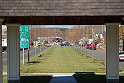 Groveland's Downtown is framed by the gazebo in Elm Park. Elm Park is a recent addition to Groveland. In the early part of the last century, Elm trees were dominant in the landscape. Then, about 1950, many Elm trees died of Dutch elm disease
. It is only recently that resistant varieties of Elm trees were developed. With this development, the townspeople built a new park, planted with the new resistant variety. Since Groveland is primarily a bedroom community, there is naturally considerable traffic during the commute drive time. However, once the rush is over, the town reverts to a sleepy little village with children, and some grownups, riding their bicycles about and walking.
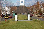 Named Constitution Park when first created in 1832 it wasn't until 1857 that the Elm trees arrived and with it the park's new name. Elm Park was the first planned housing development in the area. House lots were laid out around the common and the owners of which given rights to the well at the south end of the common. By the 1950s, Dutch elm disease had ravaged most of the trees. In the early 1960s, the last tree was taken down and the park's fountain dismantled. Thirty years later, thanks to the perseverance of Groveland residents and town officials, the town received the first of several state grants to restore Elm Park. With assistance from the Department of Environmental Management, the Historic Commission and others, Groveland has succeeded in restoring Elm Park to its historic charm.
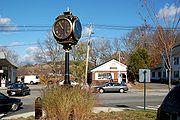 Today visitors can walk along new sidewalks lit at night by new versions of the park's original lampposts. A new fountain resembling the original, a gazebo much like the old Methodist meeting house that sat at the south end of the park, and a new clock adorn the grounds. A large stone sign and monuments to local veterans depict some of the park and town's history. The new Elm trees are planted in roughly the same pattern as the originals.
The first town post office was established in 1810 in Bradford, and was located in Squire Greenough's store on Main Street. Mr. Greenough was the postmaster until 1825, when he was succeeded by Capt. Benjamin Parker, who relocated the post office, at first, to his own store, and then to the blacksmith shop near the Haverhill Bridge. Later that same year, the building itself was moved to the other side of the street, where it remained for many years. After the town of Groveland was established in 1850, a new post office was built approximately half a mile from the present location on Main Street.
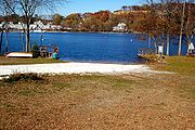
, the town has a total area of 9.4 square miles (24.3 km²), of which, 8.9 square miles (23.1 km²) of it is land and 0.5 square miles (1.3 km²) of it (4.99%) is water. The town lies along the south banks of the Merrimack River
, and several other brooks, as well as the Parker River, cross through the town. There are two ponds, Crane Pond in the eastern end of town, and Johnson's Pond, on the Boxford town line. Along with a town forest, much of the eastern corner of town is taken up by the Crane Pond Wildlife Management Area.
Groveland is located in the northwestern part of Essex County, and is bordered by Haverhill
to the west and northwest, West Newbury
to the northeast, a small portion of Newbury
to the east, Georgetown
to the southeast, and Boxford
to the southwest. Groveland's town center is located nine miles northeast of Lawrence
and thirty-one miles north of Boston
.
There are no interstates passing through Groveland, the town lying between Interstate 95
and Interstate 495
. Route 97
and Route 113 both enter the town over the Bates Bridge, a truss bridge built in 1913 carrying the roads into town from Haverhill. From the end of the bridge, Route 97 heads south through the town to Georgetown, while Route 113 bears eastward along the river towards West Newbury. In 2010, a project began to replace the bridge, 60 feet downstream, with a modern bridge. The project is expected to take two to three years and cost approximately $45 million. The Merrimack Valley Regional Transit Authority
operates a route through town; there is no other mass transit within town. The Haverhill/Reading Line
of the MBTA Commuter Rail
terminates in neighboring Haverhill, providing rail service into Boston's North Station. The nearest small craft airport is Lawrence Municipal Airport
in North Andover, and the nearest national air service can be found at Logan International Airport
. There is a bus that goes to North Station that picks up/drops off at The Tea Garden, the Chinese food restaurant and bar in town.
of 2000, there were 6,038 people, 2,058 households, and 1,706 families residing in the town. The population density
was 675.2 people per square mile (260.8/km²). There were 2,096 housing units at an average density of 234.4 per square mile (90.5/km²). The racial makeup of the town was 98.39% White, 0.35% African American, 0.13% Native American, 0.60% Asian, 0.08% from other races
, and 0.45% from two or more races. Hispanic or Latino of any race was 0.46% of the population.
There were 2,058 households, of which 43.5% had children under the age of 18 living with them, 72.4% were married couples living together, 8.0% had a female householder with no husband present, and 17.1% were non-families. 14.0% of all households were made up of individuals and 6.4% had someone living alone who was 65 years of age or older. The average household size was 2.93 and the average family size was 3.26.
In the town the population was spread out with 29.6% under the age of 18, 5.0% from 18 to 24, 31.0% from 25 to 44, 24.1% from 45 to 64, and 10.3% who were 65 years of age or older. The median age was 38 years. For every 100 females, there were 98.2 males. For every 100 females age 18 and over, there were 92.7 males.
The median income for a household in the town was $69,167, and the median income for a family was $73,996. Males had a median income of $49,201 versus $32,418 for females. The per capita income
for the town was $25,430; about 3.0% of families and 4.5% of the population were below the poverty line, including 7.1% of those under age 18 and 4.7% of those, age 65 or over.
 Groveland has an open-town meeting form of government. The Board of Selectmen comprises three members who are elected, one each year, for three-year terms, in the annual town election. The Selectmen are vested with all the municipal authority not specifically retained by the town's legislative body, town meeting, or other elected boards. The Selectmen are responsible for all facets of governmental duties. The warrants for the annual and special town meetings are generated from their office, as are any warrants for any elections or override votes scheduled. The Selectmen work together with the Finance Director, the Town Accountant, and Finance Committee members, to establish the annual operating budget for the town. Every July 1 the Selectmen appoint residents to various official boards and commissions, approve the hiring of all employees, hold public hearings on important town issues, and enforce town by-laws and regulations. The Board of Selectmen meets bi-weekly on Monday evenings, unless otherwise posted, at 6:00 in their conference room at Town Hall. Most all of the meetings on important town issues in which the public are expected to participate are held after normal "working hours." This allows the working public to participate fully in the government of the town.
 Because of the low crime-rate, there is not a lot of visible activity here. However, the police are on duty 24/7 and a dispatcher is always on site. This facility even contains a jail for temporary holding of suspects. It is very modern. The quality and capability of a Police Department has often been demonstrated by its leadership. Groveland's Police Chief Ronald Weeks has been in law enforcement for 32 years. He joined the department as a patrolman in 1974 and attended the Massachusetts Criminal Justice Training Council Academy where he was elected president of his class. He was promoted to Sergeant in 1994 and to Lieutenant in 1997. He was appointed Chief in 1999. Throughout his career, he has held positions of truant officer, training officer and court prosecutor. He holds a B.S. in Criminal Justice and a Juris Doctor degree. He has been a member of the Massachusetts Bar Association and the Haverhill Bar Association since 1994 and is currently an Adjunct Professor with Western New England College.
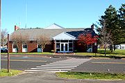
 The Fire Department consists of 40 firefighters all of which serve on a paid call basis. There Is two Stations from which the firefighters are dispatched, Central Station(as seen in the picture on the left) and South Station. The workforce is divided equally between the 2 stations 20 firefighters in central station and 20 in south station. The Fire Department serves the town in all areas of fire suppression including residential, commercial, and woodland properties. Currently the GFD has 8 in service apparatuses. In central station there is the Ladder Truck, Engine 1(pumper) Squad 1 and Tanker 1. In south station you can find Squad 2, Engine 2 (Tanker/Pumper), Engine 3 (pumper) and Combo 2 (forestry truck). It is also responsible for conducting water and ice rescue in addition to providing numerous emergency medical service calls. Fire personnel undergo rigorous and diversified training on an ongoing basis in order to develop the skills necessary to provide the services needed in a rapidly growing community. The department's equipment and manpower is designed to be flexible, efficient, effective, and tailored to addressing the specific community needs.
 Langley-Adams Library is a public library and a member of the Merrimack Valley Library Consortium, sharing borrowing privileges with other area libraries. The Langley-Adams Library uses the Horizon library automatic system, which was provided by the SirsiDynix Company and implemented in 2004.
, which includes the towns of West Newbury
and Merrimac
. Groveland itself currently has one educational institution, the Dr. Elmer S. Bagnall Elementary School. Junior and senior high school students attend Pentucket Regional Middle School and Pentucket Regional High School, respectively, which are located in West Newbury (the middle school straddles the town line between Groveland and West Newbury). The Dr. Elmer S. Bagnall Elementary School is also home to the Groveland Summer Recreation Program, a very popular non-profit summer day camp run by the Town of Groveland. Approximately 250 children between the ages of 6-15 attend this seven week recreation camp. The program runs from the last week in June to the second week in August each year. The program wrapped up its eighth season on August 13, 2010. 2011 will mark its ninth year in operation, and the program's seventh year under its current director. In 2011, the program introduced an extended day option until 5:30pm, aimed to reduce the burden on working parents during the summer months. The 2011 program officially begins on Monday, June 27, 2011 and continues through August 12, 2011. Enrollment began on February 1, 2011 and continues until space allows through the program's web site at http://www.gsrp.org.
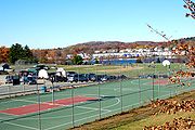 The town supports baseball and soccer fields, basketball courts, picnic areas and parks, as well as boating facilities on the Merrimack River
. In 2005, Groveland built Elm Park near its center, replacing a basketball court. The town also built a new basketball court half a mile away in the town's recreation area, the Pines. North Groveland is also home to attractions such as Stickney's Boulder and Cedardale. South Groveland contains notable attractions such as Washington Park, Nuns' Hill, Steve's Corner, and the Fertile Crescent. The town's Sand Pits, long a spot for automobile arson and adolescent hi-jinx, are soon to be converted into a mixed-income condominium complex.
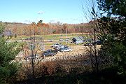
 The Pines Recreation area comprises two basketball courts, two baseball diamonds, and facilities for cookouts, bonfires, fireworks observation, plus access to the Merrimack River. A skateboard area also exists, but is not as popular as in the past. The Pines also provides a nature trail that runs through a wooded area along the river. Motor vehicles have been excluded from this trail so it is a quiet place to walk or jog. In addition to the sports facilities, the Pines Recreation area also provides swings and similar playground equipment for the youngest family members who might not yet be old enough to enjoy the sports facilities.
ZIP Code
ZIP codes are a system of postal codes used by the United States Postal Service since 1963. The term ZIP, an acronym for Zone Improvement Plan, is properly written in capital letters and was chosen to suggest that the mail travels more efficiently, and therefore more quickly, when senders use the...
01834) Groveland is a small residential town located in northern Essex County
Essex County, Massachusetts
-National protected areas:* Parker River National Wildlife Refuge* Salem Maritime National Historic Site* Saugus Iron Works National Historic Site* Thacher Island National Wildlife Refuge-Demographics:...
, bordering Boxford
Boxford, Massachusetts
Boxford is a town in Essex County, Massachusetts, United States. The population was 7,965 at the 2010 census.Part of the town comprises the census-designated place of Boxford.-Geography:...
, Georgetown
Georgetown, Massachusetts
Georgetown is a town in Essex County, Massachusetts, United States. The population was 8,183 at the 2010 census. It was incorporated in 1838 from part of Rowley.-History:...
, Haverhill
Haverhill, Massachusetts
Haverhill is a city in Essex County, Massachusetts, United States. The population was 60,879 at the 2010 census.Located on the Merrimack River, it began as a farming community that would evolve into an important industrial center, beginning with sawmills and gristmills run by water power. In the...
, and West Newbury
West Newbury, Massachusetts
West Newbury is a town in Essex County, Massachusetts, United States. Situated on the Merrimack River, its population was 4,450 at the 2006 census. Along with neighboring Merrimac and Groveland, it is part of the Pentucket Regional School District....
. The town is divided into two precincts, Groveland and South Groveland.
History
Groveland was originally the East Parish of BradfordBradford, Massachusetts
Bradford is a former town in Essex County, Massachusetts. The name currently refers to the area on the south side of the Merrimack River in Haverhill, Massachusetts that was once Bradford...
, which was originally part of the town of Rowley
Rowley, Massachusetts
Rowley is a town in Essex County, Massachusetts, United States. The population was 5,500 at the 2000 census.Part of the town comprises the census-designated place of Rowley.-History:...
. Before Bradford
Bradford, Massachusetts
Bradford is a former town in Essex County, Massachusetts. The name currently refers to the area on the south side of the Merrimack River in Haverhill, Massachusetts that was once Bradford...
was separated from Rowley and named Bradford in 1672, it was called Rowley on the Merrimack, or just Merrimack. Bradford in turn was annexed by Haverhill
Haverhill, Massachusetts
Haverhill is a city in Essex County, Massachusetts, United States. The population was 60,879 at the 2010 census.Located on the Merrimack River, it began as a farming community that would evolve into an important industrial center, beginning with sawmills and gristmills run by water power. In the...
, in 1897. Groveland officially incorporated as a separate Massachusetts
Massachusetts
The Commonwealth of Massachusetts is a state in the New England region of the northeastern United States of America. It is bordered by Rhode Island and Connecticut to the south, New York to the west, and Vermont and New Hampshire to the north; at its east lies the Atlantic Ocean. As of the 2010...
town in on September 9, 1850. Groveland residents celebrate the anniversary of this date as Groveland Day.
In December 1638 after seventeen years of service, the Reverend Ezekiel Rogers was discharged from his post as rector of the parish of Rowley
Rowley, East Riding of Yorkshire
Rowley is a small village and civil parish in the East Riding of Yorkshire, England. It is situated south of Little Weighton and approximately south-west of Beverley town centre....
in Yorkshire, England. He had refused to read "that accursed book allowing sports on the Lord's Day." Believing the future of Puritan
Puritan
The Puritans were a significant grouping of English Protestants in the 16th and 17th centuries. Puritanism in this sense was founded by some Marian exiles from the clergy shortly after the accession of Elizabeth I of England in 1558, as an activist movement within the Church of England...
ism was at stake, he and the members of twenty families sailed for the New World
New World
The New World is one of the names used for the Western Hemisphere, specifically America and sometimes Oceania . The term originated in the late 15th century, when America had been recently discovered by European explorers, expanding the geographical horizon of the people of the European middle...
. Within these families were people of means and learning, including farmers, weavers, carpenters, and smiths. They landed at Salem, Massachusetts
Salem, Massachusetts
Salem is a city in Essex County, Massachusetts, United States. The population was 40,407 at the 2000 census. It and Lawrence are the county seats of Essex County...
, but did not attempt to make a settlement until the following spring. The first printing press brought to America was onboard that same ship, the John.
Since there were no plantations left along the coastline, Reverend Rogers settled a tract of land between Ipswich
Ipswich, Massachusetts
Ipswich is a coastal town in Essex County, Massachusetts, United States. The population was 12,987 at the 2000 census. Home to Willowdale State Forest and Sandy Point State Reservation, Ipswich includes the southern part of Plum Island...
and Newbury
Newbury, Massachusetts
Newbury is a town in Essex County, Massachusetts, United States. The population was 6,666 at the 2010 census. Newbury includes the villages of Old Town , Plum Island and Byfield, home of The Governor's Academy , a private preparatory school.- History :Newbury Plantation was settled and incorporated...
, where a land boom had developed. These two towns had already established grants on this tract, so the newcomers were required to purchase them for £800. Reverend Rogers's settlement was established in modern-day Rowley
Rowley, Massachusetts
Rowley is a town in Essex County, Massachusetts, United States. The population was 5,500 at the 2000 census.Part of the town comprises the census-designated place of Rowley.-History:...
. Named Roger's Plantation and later Rowley after the English town, the initial settlement comprised sixty families. In September 1639, the town incorporated, and included the territory now occupied by Rowley, Georgetown
Georgetown, Massachusetts
Georgetown is a town in Essex County, Massachusetts, United States. The population was 8,183 at the 2010 census. It was incorporated in 1838 from part of Rowley.-History:...
, Groveland, Boxford
Boxford, Massachusetts
Boxford is a town in Essex County, Massachusetts, United States. The population was 7,965 at the 2010 census.Part of the town comprises the census-designated place of Boxford.-Geography:...
, and Bradford
Bradford, Massachusetts
Bradford is a former town in Essex County, Massachusetts. The name currently refers to the area on the south side of the Merrimack River in Haverhill, Massachusetts that was once Bradford...
.
The Congregational Church in Groveland has a bell crafted by Paul Revere
Paul Revere
Paul Revere was an American silversmith and a patriot in the American Revolution. He is most famous for alerting Colonial militia of approaching British forces before the battles of Lexington and Concord, as dramatized in Henry Wadsworth Longfellow's poem, Paul Revere's Ride...
. Of the 900 bells made by Revere's company, this is the only remaining bell in active service. In town hall, the oldest hand-pump fire-engine in the country is on display. Built in 1798 and originally named "TORRENT" of Roxbury, Massachusetts, the hand pumper was moved to Bradford, Massachusetts in 1828 and renamed "Engine 2." In 1850, the same year East Bradford became Groveland, the pumper was renamed "VETO."
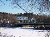
Downtown Groveland
Dutch elm disease
Dutch elm disease is a disease caused by a member of the sac fungi category, affecting elm trees which is spread by the elm bark beetle. Although believed to be originally native to Asia, the disease has been accidentally introduced into America and Europe, where it has devastated native...
. It is only recently that resistant varieties of Elm trees were developed. With this development, the townspeople built a new park, planted with the new resistant variety. Since Groveland is primarily a bedroom community, there is naturally considerable traffic during the commute drive time. However, once the rush is over, the town reverts to a sleepy little village with children, and some grownups, riding their bicycles about and walking.
The first town post office was established in 1810 in Bradford, and was located in Squire Greenough's store on Main Street. Mr. Greenough was the postmaster until 1825, when he was succeeded by Capt. Benjamin Parker, who relocated the post office, at first, to his own store, and then to the blacksmith shop near the Haverhill Bridge. Later that same year, the building itself was moved to the other side of the street, where it remained for many years. After the town of Groveland was established in 1850, a new post office was built approximately half a mile from the present location on Main Street.
Geography and Transportation
According to the United States Census BureauUnited States Census Bureau
The United States Census Bureau is the government agency that is responsible for the United States Census. It also gathers other national demographic and economic data...
, the town has a total area of 9.4 square miles (24.3 km²), of which, 8.9 square miles (23.1 km²) of it is land and 0.5 square miles (1.3 km²) of it (4.99%) is water. The town lies along the south banks of the Merrimack River
Merrimack River
The Merrimack River is a river in the northeastern United States. It rises at the confluence of the Pemigewasset and Winnipesaukee rivers in Franklin, New Hampshire, flows southward into Massachusetts, and then flows northeast until it empties into the Atlantic Ocean at Newburyport...
, and several other brooks, as well as the Parker River, cross through the town. There are two ponds, Crane Pond in the eastern end of town, and Johnson's Pond, on the Boxford town line. Along with a town forest, much of the eastern corner of town is taken up by the Crane Pond Wildlife Management Area.
Groveland is located in the northwestern part of Essex County, and is bordered by Haverhill
Haverhill, Massachusetts
Haverhill is a city in Essex County, Massachusetts, United States. The population was 60,879 at the 2010 census.Located on the Merrimack River, it began as a farming community that would evolve into an important industrial center, beginning with sawmills and gristmills run by water power. In the...
to the west and northwest, West Newbury
West Newbury, Massachusetts
West Newbury is a town in Essex County, Massachusetts, United States. Situated on the Merrimack River, its population was 4,450 at the 2006 census. Along with neighboring Merrimac and Groveland, it is part of the Pentucket Regional School District....
to the northeast, a small portion of Newbury
Newbury, Massachusetts
Newbury is a town in Essex County, Massachusetts, United States. The population was 6,666 at the 2010 census. Newbury includes the villages of Old Town , Plum Island and Byfield, home of The Governor's Academy , a private preparatory school.- History :Newbury Plantation was settled and incorporated...
to the east, Georgetown
Georgetown, Massachusetts
Georgetown is a town in Essex County, Massachusetts, United States. The population was 8,183 at the 2010 census. It was incorporated in 1838 from part of Rowley.-History:...
to the southeast, and Boxford
Boxford, Massachusetts
Boxford is a town in Essex County, Massachusetts, United States. The population was 7,965 at the 2010 census.Part of the town comprises the census-designated place of Boxford.-Geography:...
to the southwest. Groveland's town center is located nine miles northeast of Lawrence
Lawrence, Massachusetts
Lawrence is a city in Essex County, Massachusetts, United States on the Merrimack River. According to the 2010 U.S. Census, the city had a total population of 76,377. Surrounding communities include Methuen to the north, Andover to the southwest, and North Andover to the southeast. It and Salem are...
and thirty-one miles north of Boston
Boston
Boston is the capital of and largest city in Massachusetts, and is one of the oldest cities in the United States. The largest city in New England, Boston is regarded as the unofficial "Capital of New England" for its economic and cultural impact on the entire New England region. The city proper had...
.
There are no interstates passing through Groveland, the town lying between Interstate 95
Interstate 95 in Massachusetts
Interstate 95 is the main highway on the East Coast of the United States, paralleling the Atlantic Ocean from Florida to Maine. The Massachusetts portion of the highway enters from the state of Rhode Island in Attleboro and travels in a northeasterly direction to the junction with Route 128 in...
and Interstate 495
Interstate 495 (Massachusetts)
Interstate 495 is the designation of an Interstate Highway half-beltway in Massachusetts. It was the longest auxiliary Interstate Highway of its kind—measuring 120.74 miles —until 1996, when the PA Route 9 section of the Pennsylvania Turnpike was redesignated as Interstate 476, making it about ...
. Route 97
Massachusetts Route 97
Route 97 is a south–north highway in Essex County in northeastern Massachusetts. It connects the cities of Beverly and Haverhill before continuing into Salem, New Hampshire as New Hampshire Route 97.-Route description:...
and Route 113 both enter the town over the Bates Bridge, a truss bridge built in 1913 carrying the roads into town from Haverhill. From the end of the bridge, Route 97 heads south through the town to Georgetown, while Route 113 bears eastward along the river towards West Newbury. In 2010, a project began to replace the bridge, 60 feet downstream, with a modern bridge. The project is expected to take two to three years and cost approximately $45 million. The Merrimack Valley Regional Transit Authority
Merrimack Valley Regional Transit Authority
The Merrimack Valley Regional Transit Authority is a public, non-profit organization in Massachusetts, charged with providing public transportation to an area consisting of the cities and towns of Amesbury, Andover, Boxford, Georgetown, Groveland, Haverhill, Lawrence, Merrimac, Methuen, Newbury,...
operates a route through town; there is no other mass transit within town. The Haverhill/Reading Line
Haverhill/Reading Line
The Haverhill Line is a branch of the MBTA Commuter Rail system, running north from downtown Boston, Massachusetts through the cities and towns ofMalden,Melrose,Wakefield,Reading,Wilmington,Andover,...
of the MBTA Commuter Rail
MBTA Commuter Rail
The MBTA Commuter Rail serves as the regional rail arm of the Massachusetts Bay Transportation Authority, in the United States. It is operated under contract by the Massachusetts Bay Commuter Railroad Company a joint partnership of Veolia Transportation, Bombardier Transportation and Alternate...
terminates in neighboring Haverhill, providing rail service into Boston's North Station. The nearest small craft airport is Lawrence Municipal Airport
Lawrence Municipal Airport (Massachusetts)
Lawrence Municipal Airport is a public airport located two miles east of the central business district of Lawrence, a city in Essex County, Massachusetts, United States...
in North Andover, and the nearest national air service can be found at Logan International Airport
Logan International Airport
General Edward Lawrence Logan International Airport is located in the East Boston neighborhood of Boston, Massachusetts . It covers , has six runways, and employs an estimated 16,000 people. It is the 19th busiest airport in the United States.Boston serves as a focus city for JetBlue Airways...
. There is a bus that goes to North Station that picks up/drops off at The Tea Garden, the Chinese food restaurant and bar in town.
Demographics
As of the censusCensus
A census is the procedure of systematically acquiring and recording information about the members of a given population. It is a regularly occurring and official count of a particular population. The term is used mostly in connection with national population and housing censuses; other common...
of 2000, there were 6,038 people, 2,058 households, and 1,706 families residing in the town. The population density
Population density
Population density is a measurement of population per unit area or unit volume. It is frequently applied to living organisms, and particularly to humans...
was 675.2 people per square mile (260.8/km²). There were 2,096 housing units at an average density of 234.4 per square mile (90.5/km²). The racial makeup of the town was 98.39% White, 0.35% African American, 0.13% Native American, 0.60% Asian, 0.08% from other races
Race (United States Census)
Race and ethnicity in the United States Census, as defined by the Federal Office of Management and Budget and the United States Census Bureau, are self-identification data items in which residents choose the race or races with which they most closely identify, and indicate whether or not they are...
, and 0.45% from two or more races. Hispanic or Latino of any race was 0.46% of the population.
There were 2,058 households, of which 43.5% had children under the age of 18 living with them, 72.4% were married couples living together, 8.0% had a female householder with no husband present, and 17.1% were non-families. 14.0% of all households were made up of individuals and 6.4% had someone living alone who was 65 years of age or older. The average household size was 2.93 and the average family size was 3.26.
In the town the population was spread out with 29.6% under the age of 18, 5.0% from 18 to 24, 31.0% from 25 to 44, 24.1% from 45 to 64, and 10.3% who were 65 years of age or older. The median age was 38 years. For every 100 females, there were 98.2 males. For every 100 females age 18 and over, there were 92.7 males.
The median income for a household in the town was $69,167, and the median income for a family was $73,996. Males had a median income of $49,201 versus $32,418 for females. The per capita income
Per capita income
Per capita income or income per person is a measure of mean income within an economic aggregate, such as a country or city. It is calculated by taking a measure of all sources of income in the aggregate and dividing it by the total population...
for the town was $25,430; about 3.0% of families and 4.5% of the population were below the poverty line, including 7.1% of those under age 18 and 4.7% of those, age 65 or over.
Crime
The number of violent crimes recorded by the FBI in 2005 was 2 with 0 murders and homicides. The violent crime rate was 0.331 per 1,000 people.Government
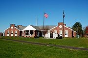
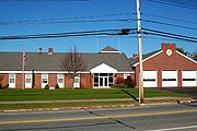
Groveland Town Hall
The town's administrative complex is located on Main Street, and contains the town hall, police and fire stations, and the Langley-Adams Library. Located at 183 Main Street, the Groveland Town Hall contains most of Groveland's municipal offices. The large windows in front expose a showroom containing historic artifacts, including the famous "VETO No. 2" fire pumper, Groveland's first fire apparatus.Groveland Police Department
Groveland Fire Department
Langley-Adams Library
Education
Groveland is a member of the Pentucket Regional School DistrictPentucket Regional School District
Pentucket Regional School District is a three town regional school district. Elementary schools are located in each town, and the high school campus is located mostly in West Newbury, Massachusetts, USA and partially in Groveland, Massachusetts, USA. The schools teach the languages French, Spanish,...
, which includes the towns of West Newbury
West Newbury, Massachusetts
West Newbury is a town in Essex County, Massachusetts, United States. Situated on the Merrimack River, its population was 4,450 at the 2006 census. Along with neighboring Merrimac and Groveland, it is part of the Pentucket Regional School District....
and Merrimac
Merrimac, Massachusetts
Merrimac is a town in Essex County, Massachusetts, United States, and on the southeastern border of New Hampshire, approximately northeast of Boston and west of the Atlantic Ocean. It is situated along the north bank of the Merrimack River in the Merrimack Valley. The population was 6,504 in 2008...
. Groveland itself currently has one educational institution, the Dr. Elmer S. Bagnall Elementary School. Junior and senior high school students attend Pentucket Regional Middle School and Pentucket Regional High School, respectively, which are located in West Newbury (the middle school straddles the town line between Groveland and West Newbury). The Dr. Elmer S. Bagnall Elementary School is also home to the Groveland Summer Recreation Program, a very popular non-profit summer day camp run by the Town of Groveland. Approximately 250 children between the ages of 6-15 attend this seven week recreation camp. The program runs from the last week in June to the second week in August each year. The program wrapped up its eighth season on August 13, 2010. 2011 will mark its ninth year in operation, and the program's seventh year under its current director. In 2011, the program introduced an extended day option until 5:30pm, aimed to reduce the burden on working parents during the summer months. The 2011 program officially begins on Monday, June 27, 2011 and continues through August 12, 2011. Enrollment began on February 1, 2011 and continues until space allows through the program's web site at http://www.gsrp.org.
Places of worship
- Groveland Congregational Church, 4 King Street
- St James Episcopal Church, 121 Washington Street
- New Destiny Christian Church, 2 Esty Way
- St Patrick's Parish, 114 Center Street (Part of Sacred Hearts Parish of Bradford,MA)
Points of interest
Merrimack River
The Merrimack River is a river in the northeastern United States. It rises at the confluence of the Pemigewasset and Winnipesaukee rivers in Franklin, New Hampshire, flows southward into Massachusetts, and then flows northeast until it empties into the Atlantic Ocean at Newburyport...
. In 2005, Groveland built Elm Park near its center, replacing a basketball court. The town also built a new basketball court half a mile away in the town's recreation area, the Pines. North Groveland is also home to attractions such as Stickney's Boulder and Cedardale. South Groveland contains notable attractions such as Washington Park, Nuns' Hill, Steve's Corner, and the Fertile Crescent. The town's Sand Pits, long a spot for automobile arson and adolescent hi-jinx, are soon to be converted into a mixed-income condominium complex.
The Pines Recreation Area
South Groveland
Notable residents
- Pat BadgerPat BadgerPat Badger is the bassist in the band Extreme. He is also a former member of Daemon, In The Pink, Super Trans Atlantic, and Tribe of Judah....
, Bassist for the Boston band ExtremeExtreme (band)Extreme is an American rock band, headed by frontmen Gary Cherone and Nuno Bettencourt, that reached the height of their popularity in the late 1980s and early 1990s.Among some of Extreme's musical influences are Queen and Van Halen... - Larry Dorr, Life long resident. Manager of Blood Sweat & Tears for 26 years, Chuck NegronChuck NegronCharles "Chuck" Negron is an American singer-songwriter, best known as one of the three lead vocalists in the band Three Dog Night, which he helped to form in 1968.-Biography:...
, Three Dog NightThree Dog NightThree Dog Night is an American rock band best known for their music from 1968 to 1975. During that time the band charted 21 Billboard top 40 hits in America, three of which reached Number One...
, Paula ColePaula ColePaula Cole is an American singer/songwriter. Her single "Where Have All the Cowboys Gone" reached the top ten of the Billboard Hot 100 in 1997, and the following year she won a Grammy Award for Best New Artist.-Early life:...
. Toured with Jesus Christ SuperstarJesus Christ SuperstarJesus Christ Superstar is a rock opera by Andrew Lloyd Webber, with lyrics by Tim Rice. The musical started off as a rock opera concept recording before its first staging on Broadway in 1971...
in the 70's. Also worked with FirefallFirefallFirefall is a rock band that formed in Boulder, Colorado in 1974. It was founded by Rick Roberts, who had been in the Flying Burrito Brothers, and Jock Bartley, who had been Tommy Bolin's replacement in Zephyr. The band's biggest hit single, "You Are the Woman", peaked at #9 on the Billboard charts...
, OrleansOrleans (band)Orleans is an American pop-rock band best known for its hits "Dance with Me" , "Still the One", from the album Waking and Dreaming and "Love Takes Time" . The group's name evolved from the music it was playing at the time of their formation, which was inspired by Louisiana artists such as Allen...
, Marvin GayeMarvin GayeMarvin Pentz Gay, Jr. , better known by his stage name Marvin Gaye, was an American singer-songwriter and musician with a three-octave vocal range....
. - Maria Stephanos, Fox 25 Boston news anchor at 6,6:30,10 and 11 p.m.
External links
- Groveland Official Town website. 183 Main St.
- Groveland Summer Recreation Program Official Site Location: Bagnall Elementary School
- Groveland Public Library. Merrimack Valley Library Consortium
- Groveland Historical Society
- Groveland Map of 1884 Atlas of Essex County
- Cedardale Website
- Extracts from the Old Parish and Church Records of the Congregational Church in Groveland (1800s).
- Groveland Congregational Church 4 King St.
- St.James Episcopal Church 119 Washington St.
- St.Patricks Church 114 Center St. open and merged with:
- Sacred Heart Church of Bradford and Groveland
- Weather in Groveland
- City guide from masscities.com
- John KerryJohn KerryJohn Forbes Kerry is the senior United States Senator from Massachusetts, the 10th most senior U.S. Senator and chairman of the Senate Foreign Relations Committee. He was the presidential nominee of the Democratic Party in the 2004 presidential election, but lost to former President George W...
and Scott BrownScott BrownScott Brown is a United States senator.Scott Brown may also refer to:-Sportsmen:*Scott Brown , American college football coach of Kentucky State...
are the US senators for Massachusetts. - John F. TierneyJohn F. TierneyJohn F. Tierney is the United States representative for . He is a member of the Democratic Party and an advocate for liberal policies and government oversight. A former attorney, he has served since 1997....
is the US Representative for the Massachusetts's 6th congressional districtMassachusetts's 6th congressional districtMassachusetts's 6th congressional district is in northeastern Massachusetts. It contains most of Essex County, including the North Shore and Cape Ann. It is currently represented by John F...
which includes Groveland. - Bruce TarrBruce TarrBruce E. Tarr is the minority leader of the Massachusetts Senate. He has been a member of the Senate since 1995, representing the 1st Essex and Middlesex District. He is a member of the United States Republican Party and a former member of the Massachusetts House of Representatives...
is the current member of the Massachusetts State Senate for the First Essex and Middlesex District. His personal website is http://www.BruceTarr.com . - Harriett Stanley is the current State Representative for the Massachusetts Second Essex District. Her personal website is http://www.HarriettLStanley.org .