

Massachusetts Route 97
Encyclopedia
Route 97 is a south–north highway in Essex County
in northeastern Massachusetts
. It connects the cities of Beverly
and Haverhill
before continuing into Salem, New Hampshire
as New Hampshire Route 97
.
in Beverly, north of the downtown area. Almost immediately, it crosses under Route 128 without intersection; the nearest exit is Exit 20 to Route 1A. Route 97 passes the Beverly Municipal Airport
before crossing into Wenham
. Route 97 passes through the western end of town, passing the Ipswich River Wildlife Sanctuary before meeting the northern end of Route 35
in Topsfield
, just over the town lines of Wenham and Danvers
.
Once in Topsfield, Route 97 crosses the Ipswich River
just east of the Topsfield Fairgrounds. It crosses U.S. Route 1
(the Newburyport Turnpike) before heading into the center of town. From there, it continues northward, entering the town of Boxford
. Route 97 passes through the village of East Boxford, where it intersects I-95
at Exit 53. It then heads northward into Georgetown
. In Georgetown, Route 97 has a brief concurrency of a tenth of a mile with Route 133
before turning northwestward along West Main Street, passing between Rock Pond and Pentucket Pond into Groveland
.
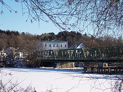
In Groveland, Route 97 meets Route 113 at the banks of the Merrimack River
, where both cross along the Bates Bridge into the city of Haverhill. The two routes pass Hale Hospital, Riverside Park and Haverhill Stadium (known locally for being the site of an exhibition game featuring Babe Ruth
) before continuing along the banks of the Merrimack. At Ginty Boulevard, Route 97 leaves Route 113, continuing to Main Street, where Route 97 turns northward, running as a wrong-way concurrency with Route 125
for one block before turning westward onto Winter Street. Route 97 intersects Route 110 before continuing westward out of the downtown area. The route intersects I-495
at Exit 50 as it cotinues into the Ayers Village section of the city. It then enters the far northeast corner of the city of Methuen
, where after only three-quarters of a mile the route enters Salem, New Hampshire and continues as New Hampshire Route 97. The stretch of Route 97 in Methuen is not directly connected to any other road within the city.
In 2010, a project began to replace the Bates Bridge, 60 feet downstream, with a modern bridge. The project is expected to take two to three years and cost approximately $45 million.
Essex County, Massachusetts
-National protected areas:* Parker River National Wildlife Refuge* Salem Maritime National Historic Site* Saugus Iron Works National Historic Site* Thacher Island National Wildlife Refuge-Demographics:...
in northeastern Massachusetts
Massachusetts
The Commonwealth of Massachusetts is a state in the New England region of the northeastern United States of America. It is bordered by Rhode Island and Connecticut to the south, New York to the west, and Vermont and New Hampshire to the north; at its east lies the Atlantic Ocean. As of the 2010...
. It connects the cities of Beverly
Beverly, Massachusetts
Beverly is a city in Essex County, Massachusetts, United States. The population was 39,343 on , which differs by no more than several hundred from the 39,862 obtained in the 2000 census. A resort, residential and manufacturing community on the North Shore, Beverly includes Beverly Farms and Prides...
and Haverhill
Haverhill, Massachusetts
Haverhill is a city in Essex County, Massachusetts, United States. The population was 60,879 at the 2010 census.Located on the Merrimack River, it began as a farming community that would evolve into an important industrial center, beginning with sawmills and gristmills run by water power. In the...
before continuing into Salem, New Hampshire
Salem, New Hampshire
Salem is a town in Rockingham County, New Hampshire, United States. The population was 28,776 at the 2010 census. Salem is a marketing and distributing center north of Boston, with a major amusement attraction, Canobie Lake Park, and a large shopping mall, the Mall at Rockingham Park.- History :The...
as New Hampshire Route 97
New Hampshire Route 97
New Hampshire Route 97 is a long east–west state highway in Salem, Rockingham County, New Hampshire. The western terminus of the route is in the center of Salem at New Hampshire Route 28 . The eastern terminus is at the Massachusetts state line, where the road continues east as Massachusetts...
.
Route description
Route 97 begins at Route 1AMassachusetts Route 1A
Route 1A is a south–north state highway in Massachusetts. It is an alternate route to U.S. 1 with three signed sections and two unsigned sections where the highway is concurrent with its parent...
in Beverly, north of the downtown area. Almost immediately, it crosses under Route 128 without intersection; the nearest exit is Exit 20 to Route 1A. Route 97 passes the Beverly Municipal Airport
Beverly Municipal Airport
Beverly Municipal Airport is a public-use airport located three miles northwest of the central business district of Beverly, a city in Essex County, Massachusetts, United States...
before crossing into Wenham
Wenham, Massachusetts
Wenham is a town in Essex County, Massachusetts, United States. The population was 4,875 at the 2010 census.The Town of Wenham was originally settled in 1635 and has retained much of its unique historic character and tranquil rural scenery...
. Route 97 passes through the western end of town, passing the Ipswich River Wildlife Sanctuary before meeting the northern end of Route 35
Massachusetts Route 35
Route 35 is a Massachusetts State Route running through the towns of Danvers and Peabody in northeastern Massachusetts.-Route description:Route 35 begins at Route 114 in Peabody, as that route turns left off the right-of-way towards Route 128 and the Northshore Mall. After passing Bishop Fenwick...
in Topsfield
Topsfield, Massachusetts
Topsfield is a town in Essex County, Massachusetts, United States. The population was 6,085 at the 2010 census.Part of the town comprises the census-designated place of Topsfield.-Colonial period:...
, just over the town lines of Wenham and Danvers
Danvers, Massachusetts
Danvers is a town in Essex County, Massachusetts, United States. Located on the Danvers River near the northeastern coast of Massachusetts, Danvers is most widely known for its association with the 1692 Salem witch trials, and for its famous asylum, the Danvers State Hospital.-17th century:The land...
.
Once in Topsfield, Route 97 crosses the Ipswich River
Ipswich River
Ipswich River is a small river in northeastern Massachusetts, USA. It is long, and its watershed is approximately , with an estimated population in the area of 160,000 people. - Geography :...
just east of the Topsfield Fairgrounds. It crosses U.S. Route 1
U.S. Route 1 in Massachusetts
In the U.S. state of Massachusetts, U.S. Route 1 is a major north–south state highway through Boston. The portion of US 1 south of Boston is also known as the Boston-Providence Turnpike, and portions north of the city are known as the Northeast Expressway and the Newburyport Turnpike.-Route...
(the Newburyport Turnpike) before heading into the center of town. From there, it continues northward, entering the town of Boxford
Boxford, Massachusetts
Boxford is a town in Essex County, Massachusetts, United States. The population was 7,965 at the 2010 census.Part of the town comprises the census-designated place of Boxford.-Geography:...
. Route 97 passes through the village of East Boxford, where it intersects I-95
Interstate 95 in Massachusetts
Interstate 95 is the main highway on the East Coast of the United States, paralleling the Atlantic Ocean from Florida to Maine. The Massachusetts portion of the highway enters from the state of Rhode Island in Attleboro and travels in a northeasterly direction to the junction with Route 128 in...
at Exit 53. It then heads northward into Georgetown
Georgetown, Massachusetts
Georgetown is a town in Essex County, Massachusetts, United States. The population was 8,183 at the 2010 census. It was incorporated in 1838 from part of Rowley.-History:...
. In Georgetown, Route 97 has a brief concurrency of a tenth of a mile with Route 133
Massachusetts Route 133
Route 133 is an east–west Massachusetts state route that runs from Lowell to Gloucester.-Route description:Route 133 begins at the junction of Route 38 and Route 110 in Lowell, where Route 110 begins a concurrency with Route 38 northbound. Route 133 heads east from this point, heading...
before turning northwestward along West Main Street, passing between Rock Pond and Pentucket Pond into Groveland
Groveland, Massachusetts
Groveland, Massachusetts Groveland is a small residential town located in northern Essex County, bordering Boxford, Georgetown, Haverhill, and West Newbury. The town is divided into two precincts, Groveland and South Groveland.-History:...
.
In Groveland, Route 97 meets Route 113 at the banks of the Merrimack River
Merrimack River
The Merrimack River is a river in the northeastern United States. It rises at the confluence of the Pemigewasset and Winnipesaukee rivers in Franklin, New Hampshire, flows southward into Massachusetts, and then flows northeast until it empties into the Atlantic Ocean at Newburyport...
, where both cross along the Bates Bridge into the city of Haverhill. The two routes pass Hale Hospital, Riverside Park and Haverhill Stadium (known locally for being the site of an exhibition game featuring Babe Ruth
Babe Ruth
George Herman Ruth, Jr. , best known as "Babe" Ruth and nicknamed "the Bambino" and "the Sultan of Swat", was an American Major League baseball player from 1914–1935...
) before continuing along the banks of the Merrimack. At Ginty Boulevard, Route 97 leaves Route 113, continuing to Main Street, where Route 97 turns northward, running as a wrong-way concurrency with Route 125
Massachusetts Route 125
Route 125 is a Massachusetts state route that while running southwest to northeast, is signed north–south. It runs from Interstate 93 in Wilmington to the Massachusetts-New Hampshire state line in Haverhill, where it continues as New Hampshire Route 125 through Plaistow to Rochester, New...
for one block before turning westward onto Winter Street. Route 97 intersects Route 110 before continuing westward out of the downtown area. The route intersects I-495
Interstate 495 (Massachusetts)
Interstate 495 is the designation of an Interstate Highway half-beltway in Massachusetts. It was the longest auxiliary Interstate Highway of its kind—measuring 120.74 miles —until 1996, when the PA Route 9 section of the Pennsylvania Turnpike was redesignated as Interstate 476, making it about ...
at Exit 50 as it cotinues into the Ayers Village section of the city. It then enters the far northeast corner of the city of Methuen
Methuen, Massachusetts
Methuen is a city in Essex County, Massachusetts, United States. The population was 43,789 at the 2000 census.-History:Methuen was first settled in 1642 and was officially incorporated in 1726; it is named for the British diplomat Sir Paul Methuen. Methuen was originally part of Haverhill,...
, where after only three-quarters of a mile the route enters Salem, New Hampshire and continues as New Hampshire Route 97. The stretch of Route 97 in Methuen is not directly connected to any other road within the city.
In 2010, a project began to replace the Bates Bridge, 60 feet downstream, with a modern bridge. The project is expected to take two to three years and cost approximately $45 million.
Junction list
| County | Location | Milepost | Roads Intersected | Notes |
|---|---|---|---|---|
| Essex Essex County, Massachusetts -National protected areas:* Parker River National Wildlife Refuge* Salem Maritime National Historic Site* Saugus Iron Works National Historic Site* Thacher Island National Wildlife Refuge-Demographics:... |
Beverly Beverly, Massachusetts Beverly is a city in Essex County, Massachusetts, United States. The population was 39,343 on , which differs by no more than several hundred from the 39,862 obtained in the 2000 census. A resort, residential and manufacturing community on the North Shore, Beverly includes Beverly Farms and Prides... |
0.00 |  Route 1A Route 1AMassachusetts Route 1A Route 1A is a south–north state highway in Massachusetts. It is an alternate route to U.S. 1 with three signed sections and two unsigned sections where the highway is concurrent with its parent... |
Southern terminus of Route 97. To Route 128 Exit 20 via Route 1A north. |
| 0.2 |  Route 128 Route 128 |
No access between Route 97 and Route 128. | ||
| Topsfield Topsfield, Massachusetts Topsfield is a town in Essex County, Massachusetts, United States. The population was 6,085 at the 2010 census.Part of the town comprises the census-designated place of Topsfield.-Colonial period:... |
3.7 |  Route 35 Route 35Massachusetts Route 35 Route 35 is a Massachusetts State Route running through the towns of Danvers and Peabody in northeastern Massachusetts.-Route description:Route 35 begins at Route 114 in Peabody, as that route turns left off the right-of-way towards Route 128 and the Northshore Mall. After passing Bishop Fenwick... South |
Northern terminus of Route 35. | |
| 5.5 |  U.S. Route 1 U.S. Route 1U.S. Route 1 in Massachusetts In the U.S. state of Massachusetts, U.S. Route 1 is a major north–south state highway through Boston. The portion of US 1 south of Boston is also known as the Boston-Providence Turnpike, and portions north of the city are known as the Northeast Expressway and the Newburyport Turnpike.-Route... |
|||
| Boxford Boxford, Massachusetts Boxford is a town in Essex County, Massachusetts, United States. The population was 7,965 at the 2010 census.Part of the town comprises the census-designated place of Boxford.-Geography:... |
9.4 |  Interstate 95 Interstate 95Interstate 95 in Massachusetts Interstate 95 is the main highway on the East Coast of the United States, paralleling the Atlantic Ocean from Florida to Maine. The Massachusetts portion of the highway enters from the state of Rhode Island in Attleboro and travels in a northeasterly direction to the junction with Route 128 in... |
Interstate 95 Exit 53. | |
| Georgetown Georgetown, Massachusetts Georgetown is a town in Essex County, Massachusetts, United States. The population was 8,183 at the 2010 census. It was incorporated in 1838 from part of Rowley.-History:... |
12.6 |  Route 133 Route 133Massachusetts Route 133 Route 133 is an east–west Massachusetts state route that runs from Lowell to Gloucester.-Route description:Route 133 begins at the junction of Route 38 and Route 110 in Lowell, where Route 110 begins a concurrency with Route 38 northbound. Route 133 heads east from this point, heading... |
Concurrency with Route 133 for one block. | |
| Groveland Groveland, Massachusetts Groveland, Massachusetts Groveland is a small residential town located in northern Essex County, bordering Boxford, Georgetown, Haverhill, and West Newbury. The town is divided into two precincts, Groveland and South Groveland.-History:... |
16.4 |  Route 113 East Route 113 East |
Beginning of concurrency with Route 113. | |
| Haverhill Haverhill, Massachusetts Haverhill is a city in Essex County, Massachusetts, United States. The population was 60,879 at the 2010 census.Located on the Merrimack River, it began as a farming community that would evolve into an important industrial center, beginning with sawmills and gristmills run by water power. In the... |
18.6 | Route 113 West |
End of concurrency with Route 113. | |
| 19.1 |  Route 125 Route 125Massachusetts Route 125 Route 125 is a Massachusetts state route that while running southwest to northeast, is signed north–south. It runs from Interstate 93 in Wilmington to the Massachusetts-New Hampshire state line in Haverhill, where it continues as New Hampshire Route 125 through Plaistow to Rochester, New... |
Concurrency with Route 125 for one block. | ||
| 19.4 |  Route 110 Route 110 |
|||
| 21.1 |  Interstate 495 Interstate 495Interstate 495 (Massachusetts) Interstate 495 is the designation of an Interstate Highway half-beltway in Massachusetts. It was the longest auxiliary Interstate Highway of its kind—measuring 120.74 miles —until 1996, when the PA Route 9 section of the Pennsylvania Turnpike was redesignated as Interstate 476, making it about ... |
Interstate 495 Exit 50. | ||
| Methuen Methuen, Massachusetts Methuen is a city in Essex County, Massachusetts, United States. The population was 43,789 at the 2000 census.-History:Methuen was first settled in 1642 and was officially incorporated in 1726; it is named for the British diplomat Sir Paul Methuen. Methuen was originally part of Haverhill,... |
24.96 |  NH Route 97 NH Route 97New Hampshire Route 97 New Hampshire Route 97 is a long east–west state highway in Salem, Rockingham County, New Hampshire. The western terminus of the route is in the center of Salem at New Hampshire Route 28 . The eastern terminus is at the Massachusetts state line, where the road continues east as Massachusetts... |
Northern end of Massachusetts Route 97. Eastern end of New Hampshire Route 97. |