
Greenslopes, Queensland
Encyclopedia
Greenslopes is a moderately sized suburb of the city of Brisbane
, state capital of Queensland
, Australia
.
"Greenslopes" is also the name of a Queensland state electorate
. The electorate contains only a small fraction of the suburb of the same name. The current Member
for Greenslopes is Cameron Dick
of the Australian Labor Party
.
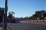
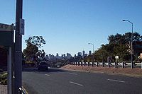 Greenslopes lies 6 km southeast of the Brisbane central business district
. There is some slight variety in the terrain, with low hills in the east and south sloping down to the flood plain of Norman Creek
, which curls around the western and northern edges of the suburb on its way to join the Brisbane River
at Norman Park
.
The major roads are:
to the west. The hill is low and its highest points are still covered in scrub. Norman Creek drains the areas surrounding the mountain.
 The suburb's population was 7683 at the 2001 Census. As an inner-city Brisbane suburb, it has moderate population density with numerous two- and three-story apartment
blocks, the result of town planning changes over the past 25 years.
 Stones Corner is characterised by a large Iraqi Muslim population, a sizeable Jewish community, a substantial Arab Christian population and a considerable Somali
and other Northeast African constituency.
Further up the hill from Stones Corner into Greenslopes there is an increasing Indian and Pakistani population of substantially Punjabi (both East and West) constituency.
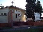
Apart from the numerous Anglican, Uniting Church and Roman Catholic parishes that are typical of Australian suburbs anywhere there is a synagogue
, a Maronite (Lebanese) Catholic Church and an Antiochian (ie Syrian, but Eastern as opposed to Oriental) Orthodox church; somewhat to the south of Greenslopes close to Logan Road is a large and prosperous Sunni mosque
with a multi-ethnic congregation.
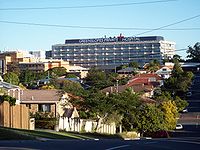 The local shopping precinct is Greenslopes Mall on Logan Road. The Greenslopes Private Hospital
, formerly Repatriation General Hospital (RGH) Greenslopes operated by the Commonwealth Government Dept of Veterans Affairs (DVA) for war veterans is located within the suburb. The hospital, surrounded by quiet streets, lies some distance from the nearest main roads, a factor which has caused friction with local residents over traffic, parking and redevelopment issues in recent years.
Other longstanding local landmarks are the Greenslopes State School and Greenslopes Bowls Club.
The Australian Institute of Applied Sciences AIAS College of Natural Medicine
is the most notable educational institution in the area. Located on Beata St, the AIAS College is a major contributor, through its large number of on campus students, to the economic development of Stones Corner.
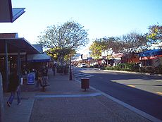 Stones Corner is a Greenslopes locality (formerly a separately designated suburb) known for its assortment of ethnic communities, ethnic retail food outlets and several sidewalk restaurants and cafés — Italian, Indian, Turkish and others — located on Logan Road near where it crosses Norman Creek.
The community is notable for its factory outlets and its longstanding large population of Indians
, Iraq
is and other Middle East
erners, Somali and other Northeast Africans and more recently, Punjabis
, particularly of Sikh
religious affiliation, who have flowed into the community as a result of recent changes in federal immigration policy.
climate, but the hot summer days are often mitigated by cooling afternoon breezes, especially in the higher areas. Winters are usually drier with very mild temperatures.
Greenslopes formed part of Stephens Shire until its amalgamation with over 20 other local shires into Greater Brisbane in 1925. The shire's name can still be seen on a plaque on the bridge where Juliette Street crosses Norman Creek.
The Brisbane City Council operated tram
s along Logan Road, through Greenslopes until 13 April 1969. Until 1957 a tram line also operated along Chatsworth Road, branching off the Logan Road line at Greenslopes.
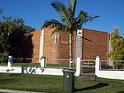
Many of the dwellings in the suburb of Greenslopes are 'character homes' of pre-war construction. Brisbane City Council purportedly recognises pre-war homes as being valuable to the identity of the suburb and enforces controls relating to the demolition and renovation of the original homes, whilst also ensuring that any new dwellings built in the suburb are reflective of traditional architecture and maintain and enhance the character of the streetscape. However, two- and three-story walk-up apartment buildings are increasingly the norm.
Brisbane
Brisbane is the capital and most populous city in the Australian state of Queensland and the third most populous city in Australia. Brisbane's metropolitan area has a population of over 2 million, and the South East Queensland urban conurbation, centred around Brisbane, encompasses a population of...
, state capital of Queensland
Queensland
Queensland is a state of Australia, occupying the north-eastern section of the mainland continent. It is bordered by the Northern Territory, South Australia and New South Wales to the west, south-west and south respectively. To the east, Queensland is bordered by the Coral Sea and Pacific Ocean...
, Australia
Australia
Australia , officially the Commonwealth of Australia, is a country in the Southern Hemisphere comprising the mainland of the Australian continent, the island of Tasmania, and numerous smaller islands in the Indian and Pacific Oceans. It is the world's sixth-largest country by total area...
.
"Greenslopes" is also the name of a Queensland state electorate
Electoral district of Greenslopes
-External links:*...
. The electorate contains only a small fraction of the suburb of the same name. The current Member
Members of the Queensland Legislative Assembly, 2004-2006
This is a list of members of the Queensland Legislative Assembly from 2004 to 2006, as elected at the 2004 state election:*Beattie Ministry...
for Greenslopes is Cameron Dick
Cameron Dick
The Honourable Cameron Robert Dick MP is the Australian Labor Party representative of the seat of Greenslopes in the Queensland Legislative Assembly...
of the Australian Labor Party
Australian Labor Party
The Australian Labor Party is an Australian political party. It has been the governing party of the Commonwealth of Australia since the 2007 federal election. Julia Gillard is the party's federal parliamentary leader and Prime Minister of Australia...
.
Geography
Brisbane central business district
The Brisbane central business district , sometimes referred to as the city, is a suburb of Brisbane, Queensland, Australia and is located on a point on the northern bank of the Brisbane River. The triangular shaped area is bounded by the Brisbane River to the east, south and west...
. There is some slight variety in the terrain, with low hills in the east and south sloping down to the flood plain of Norman Creek
Norman Creek
Norman Creek is a small tributary of the Brisbane River. The headwaters of the creek are located on the northern slopes of Toohey Mountain and Mount Gravatt in southern Brisbane.Edmund Lockyer named the waterway Norman Creek in 1825....
, which curls around the western and northern edges of the suburb on its way to join the Brisbane River
Brisbane River
The Brisbane River is the longest river in south east Queensland, Australia, and flows through the city of Brisbane, before emptying into Moreton Bay. John Oxley was the first European to explore the river who named it after the Governor of New South Wales, Thomas Brisbane in 1823...
at Norman Park
Norman Park, Queensland
Norman Park is a suburb in Brisbane, Australia. It is located 4 km east of the Brisbane central business district.Norman Park has numerous parks and recreational areas for residents in the area...
.
The major roads are:
- Logan RoadLogan Road, BrisbaneLogan Road is a major road in Brisbane, Queensland. It runs 16 km from Springwood to Woolloongabba, with most of the route signed as state route 95...
; - the Southeast FreewayPacific MotorwayThe Pacific Motorway is a 100 km long motorway in Australia between Brisbane, Queensland, and the New South Wales-Queensland border at Tweed Heads. The motorway starts at Coronation Drive at Milton in Brisbane, and from 2008 links the Tweed Heads bypass in New South Wales...
. Both Freeway and Logan Road are oriented northwest-southeast and lead from inner Brisbane to the city of LoganLogan City, QueenslandLogan City is a Local Government Area in South East Queensland, Australia. The city is situated between the City of Brisbane to the north and Gold Coast to the south. The city also borders the Scenic Rim, the City of Ipswich and Redland City....
and other points south; - Chatsworth Road, joining Greenslopes to suburbs further east, including CoorparooCoorparoo, QueenslandCoorparoo is a southern suburb of Brisbane, Queensland, Australia, located approximately four kilometres from the city. Surrounding suburbs include Camp Hill, Holland Park, Greenslopes, East Brisbane, Norman Park and Seven Hills.-Aboriginal history:...
, Camp HillCamp Hill, QueenslandCamp Hill is a largely residential suburb in the south-east of Brisbane, Queensland, Australia. It is located approximately 4 km from the Brisbane central business district and, as its name suggests, is elevated and commands fine views of the CBD. It has an area of 4.6 square...
and CarinaCarina, QueenslandCarina is an eastern suburb of Brisbane, Queensland, Australia about 7 kilometres from the Central Business District. It adjoins the suburbs of Carindale, Carina Heights, Cannon Hill and Camp Hill....
; - Old Cleveland Road, a major arterial road which also leads eastwards but reaches almost to the shores of Moreton BayMoreton BayMoreton Bay is a bay on the eastern coast of Australia 45 km from Brisbane, Queensland. It is one of Queensland's most important coastal resources...
; - the South-East BuswaySouth-East Busway, BrisbaneThe South East Busway is a grade separated bus-only corridor running south from the Brisbane CBD to Eight Mile Plains, in South East Queensland. Service providers using the Busway operate under the TransLink system...
, which tends to parallel the course of Norman Creek as it makes its way through the suburb; - Henzell Terrace, atop one of Greenslope's highest hills, which probably contains the greatest concentration of the suburb's more expensive homes.
Stephens Mountain
Stephens Mountain is one of Brisbane's largest hills. It is located in Greenslopes, between the hospital located on a ridge leading east from its highest point, and the Greenslopes busway station and the Pacific MotorwayPacific Motorway
The Pacific Motorway is a 100 km long motorway in Australia between Brisbane, Queensland, and the New South Wales-Queensland border at Tweed Heads. The motorway starts at Coronation Drive at Milton in Brisbane, and from 2008 links the Tweed Heads bypass in New South Wales...
to the west. The hill is low and its highest points are still covered in scrub. Norman Creek drains the areas surrounding the mountain.
People
Apartment
An apartment or flat is a self-contained housing unit that occupies only part of a building...
blocks, the result of town planning changes over the past 25 years.
Somali people
Somalis are an ethnic group located in the Horn of Africa, also known as the Somali Peninsula. The overwhelming majority of Somalis speak the Somali language, which is part of the Cushitic branch of the Afro-Asiatic language family...
and other Northeast African constituency.
Further up the hill from Stones Corner into Greenslopes there is an increasing Indian and Pakistani population of substantially Punjabi (both East and West) constituency.
Apart from the numerous Anglican, Uniting Church and Roman Catholic parishes that are typical of Australian suburbs anywhere there is a synagogue
Synagogue
A synagogue is a Jewish house of prayer. This use of the Greek term synagogue originates in the Septuagint where it sometimes translates the Hebrew word for assembly, kahal...
, a Maronite (Lebanese) Catholic Church and an Antiochian (ie Syrian, but Eastern as opposed to Oriental) Orthodox church; somewhat to the south of Greenslopes close to Logan Road is a large and prosperous Sunni mosque
Mosque
A mosque is a place of worship for followers of Islam. The word is likely to have entered the English language through French , from Portuguese , from Spanish , and from Berber , ultimately originating in — . The Arabic word masjid literally means a place of prostration...
with a multi-ethnic congregation.
Landmarks
Greenslopes Private Hospital
Greenslopes Private Hospital is a private health care provider located in Greenslopes, Brisbane, Australia. It was named Australia's Best Private Hospital, 1999 and received the Australian Private Hospitals Association's, Hospital Quality of Excellence Award, 2004.It is located within the...
, formerly Repatriation General Hospital (RGH) Greenslopes operated by the Commonwealth Government Dept of Veterans Affairs (DVA) for war veterans is located within the suburb. The hospital, surrounded by quiet streets, lies some distance from the nearest main roads, a factor which has caused friction with local residents over traffic, parking and redevelopment issues in recent years.
Other longstanding local landmarks are the Greenslopes State School and Greenslopes Bowls Club.
The Australian Institute of Applied Sciences AIAS College of Natural Medicine
AIAS College of Natural Medicine
- History :The AIAS College of Natural Medicine is a private educational institution located in Australia. Established in 1974, the college provides certificates, diplomas and advanced diplomas in various natural medicine modalities, including Naturopathy, Nutrition, Kinesiology, Massage, Allied...
is the most notable educational institution in the area. Located on Beata St, the AIAS College is a major contributor, through its large number of on campus students, to the economic development of Stones Corner.
Stones Corner
The community is notable for its factory outlets and its longstanding large population of Indians
Non-resident Indian and Person of Indian Origin
A Non-Resident Indian is an Indian citizen who has migrated to another country, a person of Indian origin who is born outside India, or a person of Indian origin who resides permanently outside India. Other terms with the same meaning are overseas Indian and expatriate Indian...
, Iraq
Iraq
Iraq ; officially the Republic of Iraq is a country in Western Asia spanning most of the northwestern end of the Zagros mountain range, the eastern part of the Syrian Desert and the northern part of the Arabian Desert....
is and other Middle East
Middle East
The Middle East is a region that encompasses Western Asia and Northern Africa. It is often used as a synonym for Near East, in opposition to Far East...
erners, Somali and other Northeast Africans and more recently, Punjabis
Punjabi people
The Punjabi people , ਪੰਜਾਬੀ ), also Panjabi people, are an Indo-Aryan group from South Asia. They are the second largest of the many ethnic groups in South Asia. They originate in the Punjab region, which has been been the location of some of the oldest civilizations in the world including, the...
, particularly of Sikh
Sikh
A Sikh is a follower of Sikhism. It primarily originated in the 15th century in the Punjab region of South Asia. The term "Sikh" has its origin in Sanskrit term शिष्य , meaning "disciple, student" or शिक्ष , meaning "instruction"...
religious affiliation, who have flowed into the community as a result of recent changes in federal immigration policy.
Climate
Greenslopes shares Brisbane's humid sub-tropicalSubtropics
The subtropics are the geographical and climatical zone of the Earth immediately north and south of the tropical zone, which is bounded by the Tropic of Cancer and the Tropic of Capricorn, at latitudes 23.5°N and 23.5°S...
climate, but the hot summer days are often mitigated by cooling afternoon breezes, especially in the higher areas. Winters are usually drier with very mild temperatures.
History
The name "Greenslopes" supposedly comes from the green pastures of Frederick Wecker, a German immigrant and the first settler in the district. Parts of the suburb were originally opened for settlement under names such as the Dunellan, Thompson and Mount Pleasant Estates. There is still a Dunellan Street in the suburb, adjacent to the state school.Greenslopes formed part of Stephens Shire until its amalgamation with over 20 other local shires into Greater Brisbane in 1925. The shire's name can still be seen on a plaque on the bridge where Juliette Street crosses Norman Creek.
The Brisbane City Council operated tram
Tram
A tram is a passenger rail vehicle which runs on tracks along public urban streets and also sometimes on separate rights of way. It may also run between cities and/or towns , and/or partially grade separated even in the cities...
s along Logan Road, through Greenslopes until 13 April 1969. Until 1957 a tram line also operated along Chatsworth Road, branching off the Logan Road line at Greenslopes.
Many of the dwellings in the suburb of Greenslopes are 'character homes' of pre-war construction. Brisbane City Council purportedly recognises pre-war homes as being valuable to the identity of the suburb and enforces controls relating to the demolition and renovation of the original homes, whilst also ensuring that any new dwellings built in the suburb are reflective of traditional architecture and maintain and enhance the character of the streetscape. However, two- and three-story walk-up apartment buildings are increasingly the norm.